
Palestine (region): Difference between revisions
m it really needs to be cut down |
m Primary sources not suitable for a summary article |
||
| Line 756: | Line 756: | ||
The Jewish element of the population numbers 76,000. Almost all have entered Palestine during the last 40 years. Prior to 1850 there were in the country only a handful of Jews. In the following 30 years a few hundreds came to Palestine. Most of them were animated by religious motives; they came to pray and to die in the Holy Land, and to be buried in its soil. After the persecutions in Russia forty years ago, the movement of the Jews to Palestine assumed larger proportions.<ref>[http://domino.un.org/unispal.nsf/9a798adbf322aff38525617b006d88d7/349b02280a930813052565e90048ed1c!OpenDocument Interim Report on the Civil Administration of Palestine]</ref></blockquote> |
The Jewish element of the population numbers 76,000. Almost all have entered Palestine during the last 40 years. Prior to 1850 there were in the country only a handful of Jews. In the following 30 years a few hundreds came to Palestine. Most of them were animated by religious motives; they came to pray and to die in the Holy Land, and to be buried in its soil. After the persecutions in Russia forty years ago, the movement of the Jews to Palestine assumed larger proportions.<ref>[http://domino.un.org/unispal.nsf/9a798adbf322aff38525617b006d88d7/349b02280a930813052565e90048ed1c!OpenDocument Interim Report on the Civil Administration of Palestine]</ref></blockquote> |
||
By 1948, the population had risen to 1,900,000, of whom 68% were [[Arabs]], and 32% were [[Jews]] ([[UNSCOP]] report, including [[bedouin]]). |
By 1948, the population had risen to 1,900,000, of whom 68% were [[Arabs]], and 32% were [[Jews]] ([[UNSCOP]] report, including [[bedouin]]). |
||
===Genetic analyses of regional populations=== |
|||
[[Image:Y-chromosome haplotype.png|thumb|Regions of the Y chromosome used in staining]] |
|||
According to various genetic studies, Jewish, [[Samaritan]] and Palestinian populations do overlap genetically. Palestinian Muslims additionally have genetic components that are found in the population of the [[Arabian Peninsula]], but are rare in Jews. [[Ashkenazi]] Jews also carry components found in European populations, but are rare in Arabs. |
|||
Geneticists generally agree there was mixing in Middle East populations. Nebel et al. (2000) doing [[Y-chromosome]] [[haplotype]] analysis for patrilineal ancestry of Jews and Palestinian Muslims "revealed a common gene pool for a large portion of Y chromosomes, suggesting a relatively recent common ancestry". The two modal haplotypes that comprise the Palestinian Arab [[clade]] were very infrequent among Jews, "reflecting divergence and/or admixture from other populations". Nebel et al. regard their findings in good agreement with historical evidence that suggest that "Part, or perhaps the majority, of the Muslim Arabs in this country descended from local inhabitants, mainly Christians and Jews, who had converted after the Islamic conquest in the seventh century AD... These local inhabitants, in turn, were descendants of the core population that had lived in the area for several centuries, some even since prehistoric times.<ref> [http://www.ucl.ac.uk/tcga/tcgapdf/Nebel-HG-00-IPArabs.pdf Full text] [http://www.springerlink.com/content/4b9fltx6cnc9l18q/ Journal Abstract] Almut Nebel, Dvora Filon, Deborah A. Weiss, Michael Weale, Marina Faerman, Ariella Oppenheim, Mark G. Thomas. 2000 "High-resolution Y chromosome haplotypes of Israeli and Palestinian Arabs reveal geographic substructure and substantial overlap with haplotypes of Jews". ''Human Genetics'' 107(6): 630-641.</ref> |
|||
A subsequent study aimed at determining the genetic relationship among three Jewish communities (Ashkenazi, Sephardic, and Kurdish) by the same group described two Y-chromosomal haplotype groups, J2 (formerly called Eu9) and J1 (formerly called Eu10), that represent a major part of Middle East ancestry. J2 appears to originate from the northern [[Fertile Crescent]], while J1 appears to come from the southern part of it. Jewish and Muslim Kurdish populations have high-frequency of J2 but generally lack J1, which is prevalent in Palestinian Muslims. The study proposes that <blockquote>...the Y chromosomes in Palestinian Arabs and Bedouin represent, to a large extent, early lineages derived from the Neolithic inhabitants of the area and additional lineages from more-recent population movements. The early lineages are part of the common chromosome pool shared with Jews. According to our working model, the more-recent migrations were mostly from the Arabian Peninsula, as is seen in the Arab-specific Eu 10 [namely J1] chromosomes that include the modal haplotypes observed in Palestinians and Bedouin... The study demonstrates that the Y chromosome pool of Jews is an integral part of the genetic landscape of the region and, in particular, that Jews exhibit a high degree of genetic affinity to populations living in the north of the Fertile Crescent [namely J2].<ref>[http://www.pubmedcentral.nih.gov/articlerender.fcgi?tool=pubmed&pubmedid=11573163 Journal Article:] Almut Nebel, Dvora Filon, Bernd Brinkmann, Partha P. Majumder, Marina Faerman, Ariella Oppenheim. 2001. "The Y Chromosome Pool of Jews as Part of the Genetic Landscape of the Middle East". ''American Journal of Human Genetics'' 69(5): 1095–1112.</ref> |
|||
</blockquote> |
|||
===The question of late Arab immigration to Palestine=== |
===The question of late Arab immigration to Palestine=== |
||
Revision as of 19:21, 9 June 2009
This article may be too long to read and navigate comfortably. |

Palestine (Greek: Παλαιστίνη, Palaistinē; Latin: Palaestina; Hebrew: פלשתינה Palestina; Arabic: فلسطين [Filasṭīn] Error: {{Lang}}: text has italic markup (help), [Falasṭīn] Error: {{Lang}}: text has italic markup (help), [Filisṭīn] Error: {{Lang}}: text has italic markup (help)) is a name which has been widely used since Roman times to refer to the region that was earlier called Judea, which spreads between the Mediterranean Sea and the Jordan River.[1] It is derived from a name used already much earlier for a narrower geographical region, mainly along the coast.
In its broader meaning as a geographical term, Palestine can refer to an area that includes contemporary Israel and the Palestinian territories, parts of Jordan, and parts of Lebanon and Syria. In its narrow meaning, it can refer to the area within the boundaries of the former British Mandate of Palestine (1920-1948) west of the Jordan River; the Country, or State of Palestine, comprised of territory in the West Bank and Gaza Strip;[2] or to Proposals for a Palestinian state in line with the pre-1967 borders.[3]
Name and boundaries
The name and the borders of Palestine have varied throughout history, though Palestine has certain natural boundaries that justify its historical individuality. The name itself was given to these lands by the Romans around 135 CE when the emperor Hadrian brutally suppressed the Jewish Resistance movement and occupied Judea. They called it the Province of Syria Palaestina and built a temple to Jupiter on Israel's destroyed holiest site.
According to the Jewish Encyclopedia published between 1901-1906:
Palestine extends, from 31° to 33° 20′ N. latitude. Its southwest point (at Raphia = Tell Rifaḥ, southwest of Gaza) is about 34° 15′ E. longitude, and its northwest point (mouth of the Liṭani) is at 35° 15′ E. longitude, while the course of the Jordan reaches 35° 35′ to the east. The west-Jordan country has, consequently, a length of about 150 English miles from north to south, and a breadth of about 23 miles at the north and 80 miles at the south. The area of this region, as measured by the surveyors of the English Palestine Exploration Fund, is about 6,040 square miles. The east-Jordan district is now being surveyed by the German Palästina-Verein, and although the work is not yet completed, its area may be estimated at 4,000 square miles. This entire region, as stated above, was not occupied exclusively by the Israelites, for the plain along the coast in the south belonged to the Philistines, and that in the north to the Phenicians, while in the east-Jordan country the Israelitic possessions never extended farther than the Arnon (Wadi al-Mujib) in the south, nor did the Israelites ever settle in the most northerly and easterly portions of the plain of Bashan. To-day the number of inhabitants does not exceed 650,000. Palestine, and especially the Israelitic state, covered, therefore, a very small area, approximating that of the state of Vermont.
Some other terms that have been used to refer to all or part of this area include Canaan, Greater Israel, Greater Syria, the Holy Land, Iudaea Province, Judea[5], Israel, "Israel HaShlema", Kingdom of Israel, Kingdom of Jerusalem, Land of Israel (Eretz Yisrael or Ha'aretz), Levant, Retenu (Ancient Egyptian), Southern Syria, and Syria Palestina.
In the Bible, the area inhabited by the Philistines was known as Pleshet Genesis, X.13. The Philistines were a seafaring people who lived in cities along the coast. During the Late Bronze Age, Philistia was located approximately where the Gaza Strip is situated. Philistia was a confederation of five city states: Gaza, Ashkelon and Ashdod on the coast, and Ekron and Gath inland.[6]
The ethnic affiliation of the Philistines is not clear. The Philistine names preserved on inscriptions appear to "contradict the notion that they were Greek-speakers."[7] Some scholars argue however that they were a non-Semitic group, with roots in Southern Greece dating back to the period of early Mycenaean civilization.[8] A hypothetical link to the Anatolian people, based upon mere phonological similitude to the Palaic language, seems tenuous but not impossible.
Non-Biblical texts
Ancient Egyptian texts called the entire coastal area along the Mediterranean Sea between modern Egypt and Turkey R-t-n-u (conventionally Retjenu). Retjenu was subdivided into three regions and the southern region, Djahy, shared approximately the same boundaries as Canaan, or modern-day Israel and the Palestinian territories, though including also Syria.[9]

Early archeological textual reference to the territory of Palestine is found in the Merneptah Stele, dated c. 1200 BCE, containing a recount of Egyptian king Merneptah's victories in the land of Canaan, mentioning place-names such as Gezer, Ashkelon and Yanoam, along with Israel, which is mentioned using a hieroglyphic determinative that indicates a nomad people, rather than a state.[10]
Egyptian texts of the temple at Medinet Habu, record a people called the P-r-s-t (conventionally Peleset), one of the Sea Peoples who invaded Egypt in Ramesses III's reign. This is considered very likely to be a reference to the Philistines. The Hebrew name Peleshet (פלשת [Pəléshseth] Error: {{Lang}}: text has italic markup (help)) usually translated as Philistia in English, is used in the Bible to denote "the coastal region north and south of Gaza which was occupied and settled by Philistine invaders from across the sea".[11]
.jpg)
Another famous inscription is that of the Mesha Stele, bearing an inscription by the 9th century BC Moabite King Mesha, discovered in 1868 at Dhiban (biblical "Dibon," capital of Moab) now in Jordan. The Stele is notable because it is thought to be the earliest known reference to the sacred Hebrew name of God - YHWH. It also notable as the most extensive inscription ever recovered that refers to ancient Israel (see more below).
The Assyrian emperor Sargon II called the region the Palashtu in his Annals. By the time of Assyrian rule in 722 BCE, the Philistines had become 'part and parcel of the local population',[12][13] and prospered under Assyrian rule during the seventh century despite occasional rebellions against their overlords.[6] In 604 BCE, when Assyrian troops commanded by the Babylonian empire carried off significant numbers of the population into slavery, the distinctly Philistine character of the coastal cities dwindled away,[12][14] and the history of the Philistine people effectively ended.[6]
In the 5th century BCE, the Greek historian and geographer Herodotus wrote in Greek of a "district of Syria, called Παλαιστινη ([Palaistinê] Error: {{Lang}}: text has italic markup (help))."[15][16][17] Syria, at that time, referred rather imprecisely to the region lying between Asia Minor, Sinai, the Mediterranean Sea and the Persian Gulf. The boundaries of the "district" of Palaistinê described by Herodotus are even more imprecise, as is the ethnic nature of its people; sometimes it denotes the coast north of Mount Carmel, and elsewhere it seems to extend down all the coast from Phoenicia to Egypt, and as far east as the Jordan River.[18]
During the Roman period, the province of Iudaea covered much of modern Palestine, although the Galilee and other northern areas remained distinct administratively. However, many writers continued to use the Greek name. For example, in the first century C.E., the Roman writer Pliny the Elder mentions a region of Syria that was "formerly called Palaestina" among the areas of the Eastern Mediterranean.[19] The Jewish historian Josephus, writing in Greek, used the name Palaistinê for the smaller coastal area which most of his contemporaries preferred to call Philistia.[20] the Jewish writer Philo of Alexandria, also writing in Greek, used the terms Palestine and Canaan interchangeably, noting that the region's Jewish population was larger than that of any other single country.[21]
After the Jewish rebellions of the first and second centuries CE, the Romans merged the province of Iudaea with Galilee, Samaria and Idumaea, uniting the entire area in a new province bearing the Greco-Latin name Syria-Palaestina.[22][23]. The application of the Latinized name Palaestina to the region of the Iudaea Province by the Roman emperor Hadrian[24][25] following the crushing Bar Kochba's revolt in 132-135[26] is seen by some historians as an attempt to suppress Jewish national feelings.[27][28]
During the Byzantine Period, this entire region (including Syria, Palestine, Samaria, and Galilee) was renamed Palaestina and then subdivided into Diocese I and II. The Byzantines also renamed an area of land including the Negev, Sinai, and the west coast of the Arabian Peninsula as Palaestina Salutoris, sometimes called Palaestina III. Since the Byzantine Period, the Byzantine borders of Palaestina (I and II) have served as a name for the geographic area between the Jordan River and the Mediterranean Sea.
The use of the term Palestine became more common place after the European renaissance.[29]
The Zionist Organization provided their definition concerning the boundaries of Palestine in a statement to the Paris Peace Conference in 1919; it also includes a statement about the importance of water resources that the designated area includes.[30][31] On the basis of a League of Nations mandate, the British administered Palestine after World War I, promising to establish a Jewish homeland therein [32]. The original British Mandate included what is now Israel, the West Bank (of the Jordan), and trans-Jordan (the present kingdom of Jordan), although the latter was disattached by an administrative decision of the British in 1922 [33]. These proposed boundaries, although superseded by later colonial decisions of the Mandate Administration, included portions of present-day southern Lebanon, southwestern Syria and western Jordan, as well as Israel and the Palestinian territories.
Biblical texts

In the Biblical account, the United Kingdom of Israel and Judah ruled from Jerusalem a vast territory extending far west and north of Palestine for some 120 years. Archaeological evidence for this period is very rare, however, and its implications much disputed.[34][35]
The Hebrew Bible calls the region [Canaan] Error: {{Lang}}: text has italic markup (help) (כּנען) (Numbers 34:1–12), while the part of it occupied by Israelites is designated Israel ([Yisrael] Error: {{Lang}}: text has italic markup (help)). The name "Land of the Hebrews" (ארץ העברים, [Eretz Ha-Ivrim] Error: {{Lang}}: text has italic markup (help)) is also found, as well as several poetical names: "land flowing with milk and honey", "land that [God] swore to your fathers to assign to you", "Land of the Lord", and the "Promised Land".
The Land of Canaan is given a precise description in (34:1 Numbers 34:1–12) as including all of Lebanon, as well (13:5 Joshua 13:5). The wide area appears to have been the home of several small nations such as the Canaanites, Hebrews, Hittites, Amorrhites, Pherezites, Hevites and Jebusites. According to Hebrew tradition, the land of Canaan is part of the land given to the descendants of Abraham, which extends from the Nile to the Euphrates River (15:18 Genesis 15:18).
In 13:17 Exodus 13:17, "And it came to pass, when Pharaoh had let the people go, that God led them not through the way of the land of the Philistines, although that was near; for God said, Lest peradventure the people repent when they see war, and they return to Egypt."
The events of the Four Gospels of the Christian Bible take place almost entirely in this country, which in Christian tradition thereafter became known as The Holy Land.
In the Qur'an, the term الأرض المقدسة ([Al-Ard Al-Muqaddasah] Error: {{Lang}}: text has italic markup (help), English: "Holy Land") is mentioned at least seven times, once when Moses proclaims to the Children of Israel: "O my people! Enter the holy land which Allah hath assigned unto you, and turn not back ignominiously, for then will ye be overthrown, to your own ruin." (Surah 5:21)
History
Paleolithic and Neolithic periods (1 mya–5000 BCE)
The earliest human remains in Palestine were found in Ubeidiya, some 3 km south of the the, in the Jordan Rift Valley. The remains are dated to the Pleistocene, ca. 1.5 million years ago. It is traces of the earliest migration of Homo erectus out of Africa. The site yielded hand axes of the Acheulean type. [36].
Wadi El Amud between Safad and the Sea of Galilee] was the site of the first prehistoric digging in Palestine, in 1925. The discovery of the Palestine Man in the Zuttiyeh Cave in Wadi Al-Amud near Safad in 1925 provided some clues to human development in the area.[37][38]
Qafzeh, is a paleoanthropological site south of Nazareth where eleven significant fossilised Homo sapiens skeletons have been found at the main rock shelter. These anatomically modern humans, both adult and infant, are now dated to circa 90-100,000 years old, and many of the bones are stained with red ochre which is conjectured to have been used in the burial process, a significant indicator of ritual behavior and thereby symbolic thought and intelligence. 71 pieces of unused red ochre also littered the site.
Mount Carmel has yielded several important findings, among them Kebara Cave that was inhabited between 60,000 - 48,000 BP and where the most complete Neanderthal skeleton found to date. The Tabun cave was occupied intermittently during the Lower and Middle Paleolithic ages (500,000 to around 40,000 years ago). Excavation suggests that it features one of the longest sequences of human occupation in the Levant. In the nearby Es Skhul cave excavations revealed the first evidence of the late Epipalaeolithic Natufian culture, characterized by the presence of abundant microliths, human burials and ground stone tools. This also represents one area where Neanderthals - present in the region from 200,000 - 45,000 years ago - lived alongside modern humans dating to 100,000 years ago.[39].
In the caves of Shuqba in Ramallah and Wadi Khareitun in Bethlehem, stone, wood and animal bone tools were found and attributed to the Natufian culture (c. 12800–10300 BCE). Other remains from this era have been found at Tel Abu Hureura, Ein Mallaha, Beidha and Jericho.[40]

Between 10000 and 5000 BCE, agricultural communities were established. Evidence of such settlements were found at Tel es-Sultan in Jericho and consisted of a number of walls, a religious shrine, and a 23-foot (7.0 m) tower with an internal staircase [41][42] Jericho is believed to be one of the oldest continuously-inhabited cities in the world, with evidence of settlement dating back to 9000 BC, providing important information about early human habitation in the Near East.[43]
Chalcolithic period (4500–3000 BCE) and Bronze Age (3000–1200 BCE)

Along the Jericho-Dead Sea-Bir es-Saba-Gaza-Sinai route, a culture originating in Syria, marked by the use of copper and stone tools, brought new migrant groups to the region contributing to an increasingly urban fabric.[44][45][46]
By the early Bronze Age (3000–2200 BCE) independent Canaanite city-states situated in plains and coastal regions and surrounded by mud-brick defensive walls were established and most of these cities relied on nearby agricultural hamlets for their food needs.[44][47]
Archaeological finds from the early Canaanite era have been found at Tel Megiddo, Jericho, Tel al-Far'a (Gaza), Bisan, and Ai (Deir Dibwan/Ramallah District), Tel an Nasbe (al-Bireh) and Jib (Jerusalem).
The Canaanite city-states held trade and diplomatic relations with Egypt and Syria. Parts of the Canaanite urban civilization were destroyed around 2300 BCE, though there is no consensus as to why. Incursions by nomads from the east of the Jordan River who settled in the hills followed soon thereafter.[44][48]
In the Middle Bronze Age (2200–1500 BCE), Canaan was influenced by the surrounding civilizations of Egypt, Mesopotamia, Phoenicia, and Syria. Diverse commercial ties and an agriculturally based economy led to the development of new pottery forms, the cultivation of grapes, and the extensive use of bronze.[44][49] Burial customs from this time seemed to be influenced by a belief in the afterlife.[44][50]
Political, commercial and military events during the Late Bronze Age period (1450–1350 BCE) were recorded by ambassadors and Canaanite proxy rulers for Egypt in 379 cuneiform tablets known as the Amarna Letters.[51]
By c. 1190 BCE, the Philistines arrived and mingled with the local population, losing their separate identity over several generations.[12][52]
Iron Age (1200–330 BCE)
Pottery remains found in Ashkelon, Ashdod, Gat, Ekron and Gaza decorated with stylized birds provided the first archaeological evidence for Philistine settlement in the region. The Philistines are credited with introducing iron weapons and chariots to the local population.[53]
Developments in Palestine between 1250 and 900 BCE have been the focus of debate between those who accept the Old Testament version on the conquest of Canaan by the Israelite tribes, and those who reject it.[54] Niels Peter Lemche, of the Copenhagen School of Biblical Studies, submits that the picture of ancient Israel "is contrary to any image of ancient Palestinian society that can be established on the basis of ancient sources from Palestine or referring to Palestine and that there is no way this image in the Bible can be reconciled with the historical past of the region."[55]
The "David's Palace" site,[56] the sacrificial site at Shechem[57] and the Merneptah Stele,[58][59][60] and Mesha Stele[61][62][63] among others are subject to different historical interpretations: scholars in the "conservative camp" reconstruct the history of Israel according to the biblical text and view the archaeological evidence in that context, whilst scholars in the minimalist or deconstructionist school argue that there is no archaeological evidence supporting the United Monarchy because the biblical account is a religious mythology created wholly by Judean scribes in the Persian and Hellenistic periods; a third camp of centrist scholars acknowledges the value of some isolated elements of the Pentateuch and of Deuteronomonistic accounts as potentially valid history of monarchic times that can be in accord with the archaeological evidence, but argue that nevertheless the biblical narrative should be understood as highly ideological and adapted to the needs of the community at the time of its compilation.[64]
Hebrew Bible period

Though the Biblical tradition holds that the Israelites arrived in Canaan from Egypt, archaeology provides strong evidence that they emerged from among the local population existent there at the time; these events are generally dated to between the 13th and 12th centuries BCE.[54] Archaeological evidence indicates that the late 13th, the 12th and the early 11th centuries BCE witnessed the foundation of perhaps hundreds of insignificant, unprotected village settlements, many in the mountains of Palestine.[55] From around the 11th century BCE, there was a reduction in the number of villages, though this was counterbalanced by the rise of certain settlements to the status of fortified townships.[55]
According to Biblical tradition, the United Kingdom of Israel was established by the Israelite tribes with Saul as its first king in 1020 BCE.[65] In 1000 BCE, Jerusalem was made the capital of King David's kingdom and it is believed that the First Temple was constructed in this period by King Solomon.[65] By 930 BCE, the united kingdom split to form the northern Kingdom of Israel, and the southern Kingdom of Judah.[65] These kingdoms co-existed with several more kingdoms in the greater Palestine area, including Philistine town states on the Southwestern Mediterranean coast, Edom, to the South of Judah, and Moab and Ammon to the East of the river Jordan.[66]
There was an at least partial Egyptian withdrawal from Palestine in this period, though it is likely that Bet Shean was an Egyptian garrison as late as the beginning of the 10th century BCE.[55] The socio-political system was characterized by local patrons fighting other local patrons, lasting until around the mid-9th century BCE when some local chieftains were able to create large political structures that exceeded the boundaries of those present in the Late Bronze Age Levant.[55]
Archaeological findings from this era include, among others, the Mesha Stele, from c. 850 BCE, which recounts the conquering of Moab, located East of the Dead Sea, by king Omri, and the successful revolt of Moabian king Mesha against Omri's son, presumably King Ahab (and French scholar André Lemaire reported that line 31 of the Stele bears the phrase "the house of David" (in Biblical Archaeology Review [May/June 1994], pp. 30–37).[67]); and the Kurkh Monolith, dated c. 835 BCE, describing King Shalmaneser III of Assyria's Battle of Qarqar, where he fought alongside the contingents of several kings, among them King Ahab and King Gindibu.
Between 722 and 720 BCE, the northern Kingdom of Israel was destroyed by the Assyrian Empire and the Israelite tribes - thereafter known as the Lost Tribes - were exiled.[65] The most important finding from the southern Kingdom of Judah is the Siloam Inscription, dated c. 700 BCE, which celebrates the successful encounter of diggers, digging from both sides of the Jerusalem wall to create the Hezekiah water tunnel and water pool, mentioned in the Bible, in 2Kings 20:20.[citation needed] In 586 BCE, Judah was conquered by the Babylonians and Jerusalem and the First Temple destroyed.[65] Most of the surviving Jews, and much of the other local population, were deported to Babylonia.[12][68]
Persian rule (538 BCE)
After the Persian Empire was established, Jews were allowed to return to what their holy books had termed the Land of Israel, and having been granted some autonomy by the Persian administration, it was during this period that the Second Temple in Jerusalem was built.[12][69] Sebastia, near Nablus, was the northernmost province of the Persian administration in Palestine, and its southern borders were drawn at Hebron.[12][70] Some of the local population served as soldiers and lay people in the Persian administration, while others continued to agriculture. In 400 BCE, the Nabataeans made inroads into southern Palestine and built a separate civilization in the Negev that lasted until 160 BCE.[12][71]
Classical antiquity
Hellenistic rule (333 BCE)
The Persian Empire fell to Greek forces of the Macedonian general Alexander the Great.[72][73] After his death, with the absence of heirs, his conquests were divided amongst his generals, while the region of the Jews ("Judah" or Judea as it became known) was first part of the Ptolemaic dynasty and then part of the Seleucid Empire.[74]
The landscape during this period was markedly changed by extensive growth and development that included urban planning and the establishment of well-built fortified cities.[70][72] Hellenistic pottery was produced that absorbed Philistine traditions. Trade and commerce flourished, particularly in the most Hellenized areas, such as Ascalon, Jaffa,[75] Jerusalem,[76] Gaza,[77] and ancient Nablus (Tell Balatah).[72][78]
The Jewish population in Judea was allowed limited autonomy in religion and administration.[79]
Hasmonean dynasty (140 BCE)

An independent Jewish kingdom under the Hasmonean Dynasty existed from 140–37 BCE. In the second century BCE fascination in Jerusalem for Greek culture resulted in a movement to break down the separation of Jew and Gentile and some people even tried to disguise the marks of their circumcision.[80] Disputes between the leaders of the reform movement, Jason and Menelaus, eventually led to civil war and the intervention of Antiochus IV Epiphanes.[80] Subsequent persecution of the Jews led to the Maccabean Revolt under the leadership of the Hasmoneans, and the construction of a native Jewish kingship under the Hasmonean Dynasty.[80] After approximately a century of independence disputes between the Hasmonean rivals Aristobulus and Hyrcanus led to control of the kingdom by the Roman army of Pompey. The territory then became first a Roman client kingdom under Hyrcanus and then, in 70CE, a Roman Province administered by the governor of Syria.[81]
Roman rule (63 BCE)

Though General Pompey arrived in 63 BCE, Roman rule was solidified when Herod, whose dynasty was of Idumean ancestry, was appointed as king.[72][82] Urban planning under the Romans was characterized by cities designed around the Forum - the central intersection of two main streets - the Cardo, running north-south and the Decumanus running east-west.[83] Cities were connected by an extensive road network developed for economic and military purposes. Among the most notable archaeological remnants from this era are Herodium (Tel al-Fureidis) to the south of Bethlehem[84], Masada and Caesarea Maritima.[72][85]. Herod arranged a renovation of the Second Temple in Jerusalem, with a massive expansion of the Temple Mount platform and major expansion of the Jewish Temple around 19 BCE. The Temple Mount's natural plateau was extended by enclosing the area with four massive retaining walls and filling the voids. This artificial expansion resulted in a large flat expanse which today forms the eastern section of the Old City of Jerusalem.
Around the time associated with the birth of Jesus, Roman Palestine was in a state of disarray and direct Roman rule was re-established.[72][86] The early Christians were oppressed and while most inhabitants became Romanized, others, particularly Jews, found Roman rule to be unbearable.[72][86]

As a result of the First Jewish-Roman War (66-73), Titus sacked Jerusalem destroying the Second Temple, leaving only supporting walls, including the Western Wall.

In 135, following the fall of a Jewish revolt led by Bar Kokhba in 132–135, the Roman emperor Hadrian attempted the expulsion of Jews from Judea. His attempt was as unsuccessful as were most of Rome's many attempts to alter the demography of the Empire; this is demonstrated by the continued existence of the rabbinical academy of Lydda in Judea, and in any case large Jewish populations remained in Samaria and the Galilee.[22] Tiberias became the headquarters of exiled Jewish patriarchs. The Romans joined the province of Judea (which already included Samaria) together with Galilee to form a new province, called Syria Palaestina, to complete the disassociation with Judaea.[22] Notwithstanding the oppression, some two hundred Jewish communities remained. Gradually, certain religious freedoms were restored to the Jewish population, such as exemption from the imperial cult and internal self-administration. The Romans made no such concession to the Samaritans, to whom religious liberties were denied, while their sanctuary on Mt.Gerizim was defiled by a pagan temple, as part of measures were taken to suppress the resurgence of Samaritan nationalism.[22]
In 132 CE, the Emperor Hadrian changed the name of the province from Iudaea to Syria Palaestina and renamed Jerusalem "Aelia Capitolina" and built temples there to honor Jupiter. Christianity was practiced in secret and the Hellenization of Palestine continued under Septimius Severus (193–211 CE).[72] New pagan cities were founded in Judea at Eleutheropolis (Bayt Jibrin), Diopolis (Lydd), and Nicopolis (Emmaus).[70][72]
Byzantine (Eastern Roman Empire) rule (330–640 CE)

Emperor Constantine's conversion to Christianity around 330 CE made Christianity the official religion of Palaestina.[87][88] After his mother Empress Helena identified the spot she believed to be where Christ was crucified, the Church of the Holy Sepulcher was built in Jerusalem.[87] The Church of the Nativity in Bethlehem and the Church of the Ascension in Jerusalem were also built during Constantine's reign.[87] This was the period of its greatest prosperity in antiquity. Urbanization increased, large new areas were put under cultivation, monasteries proliferated, synagogues were restored, and the population West of the Jordan may have reached as many as one million.[22]
Palestine thus became a center for pilgrims and ascetic life for men and women from all over the world.[70][87] Many monasteries were built including the St. George's Monastery in Wadi al-Qelt, the Monastery of the Temptation and Deir Hajla near Jericho, and Deir Mar Saba and Deir Theodosius east of Bethlehem.[87]
In 352 CE, a Jewish revolt against Byzantine rule in Tiberias and other parts of the Galilee was brutally suppressed. Imperial patronage for Christian cults and immigration was strong, and a significant wave of immigration from Rome, especially to the area about Aelia Capitolina and Bethlehem, took place after that city was sacked in 410.[22]
In approximately 390 CE, Palaestina was further organised into three units: Palaestina Prima, Secunda, and Tertia (First, Second, and Third Palestine).[89][87] Palaestina Prima consisted of Judea, Samaria, the coast, and Peraea with the governor residing in Caesarea. Palaestina Secunda consisted of the Galilee, the lower Jezreel Valley, the regions east of Galilee, and the western part of the former Decapolis with the seat of government at Scythopolis. Palaestina Tertia included the Negev, southern Jordan — once part of Arabia — and most of Sinai with Petra as the usual residence of the governor. Palestina Tertia was also known as Palaestina Salutaris.[87][90]
In 536 CE, Justinian I promoted the governor at Caesarea to proconsul (anthypatos), giving him authority over the two remaining consulars. Justinian believed that the elevation of the governor was appropriate because he was responsible for "the province in which our Lord Jesus Christ... appeared on earth".[91] This was also the principal factor explaining why Palestine prospered under the Christian Empire. The cities of Palestine, such as Caesarea Maritima, Jerusalem, Scythopolis, Neapolis, and Gaza reached their peak population in the late Roman period and produced notable Christian scholars in the disciplines of rhetoric, historiography, Eusebian ecclesiastical history, classicizing history and hagiography.[91]
Byzantine administration of Palestine was temporarily suspended during the Persian occupation of 614–28, and then permanently after the Muslims arrived in 634 CE, defeating the empire's forces decisively at the Battle of Yarmouk in 636 CE. Jerusalem capitulated in 638 CE and Caesarea between 640 CE and 642 CE.[91]
Islamic period (630-1918 CE)
The Islamic prophet Muhammad established a new unified political polity in the Arabian peninsula at the beginning of the seventh century. The subsequent Rashidun and Umayyad Caliphates saw a century of rapid expansion of Arab power well beyond the Arabian peninsula in the form of a vast Muslim Arab Empire. In the fourth decade of the the seventh century this empire conquered Palestine and it remained under the control of Islamic Empires for most of the next 1300 years.
Arab Caliphate rule (638–1099 CE)

In 638 CE, following the Siege of Jerusalem, the Caliph Omar Ibn al-Khattab and Safforonius, the Patriarch of Jerusalem, signed Al-Uhda al-'Omariyya (The Umariyya Covenant), an agreement that stipulated the rights and obligations of all non-Muslims in Palestine.[87] Christians and Jews where considered People of the Book, enjoyed some protection but had to a pay special poll tax called jizyah ("tribute"). During the early years of Muslim control of the city, a small permanent Jewish population returned to Jerusalem after a 500-year absence[92].
Omar Ibn al-Khattab was the first conqueror of Jerusalem to enter the city on foot, and when visiting the site that now houses the Haram al-Sharif, he declared it a sacred place of prayer.[93][94]
Umayyad rule (661–750 CE)
Under Umayyad rule, the Byzantine province of Palaestina Prima became the administrative and military sub-province (jund) of Filastin - the Arabic name for Palestine from that point forward.[95] It formed part of the larger province of ash-Sham (Arabic for Greater Syria).[96] Jund Filastin (Arabic جند فلسطين, literally "the army of Palestine") was a region extending from the Sinai to the plain of Acre. Major towns included Rafah, Caesarea, Gaza, Jaffa, Nablus and Jericho.[97] Lod served served as the headquarters of the province of Filastin and the capital later moved to Ramla. Jund al-Urdunn (literally "the army of Jordan") was a region to the north and east of Filastin which included the cities of Acre, Bisan and Tiberias.[97]

In 691, Caliph Abd al-Malik ibn Marwan ordered that the Dome of the Rock be built on the site where the Islamic prophet Muhammad is believed by Muslims to have begun his nocturnal journey to heaven, on the Temple Mount. About a decade afterward, Caliph Al-Walid I had the Al-Aqsa Mosque built.[98]
During the rule of the Umayyads the process of Islamization and Arabization of the population gained momentum. The Umayyad caliph Umar II (717–720) imposed humiliating restrictions on his non-Muslim subjects, causing Christians to convert. These conversion together with the immigration from the Arabian Peninsula changed the religious character of the country. [99]
Abbasid rule (750–969 CE)
In 750 the Abbasid Caliphs took over the Ara Empire and moved the capital to Baghdad from Damascus. During the rule of the Abbasids Caliphs Palestine was much less central than in Umayyads time. One reason is the geographical distance from the capital. The influence of Arab tribes has declined and the only context where they are reported is in uprising against the central authority. [100]. The Abbasids visited the country less frequently than the Ummayads , but ordered some significant constructions in Jerusalem. Thus, Al-Mansur Ordered in 758 the renovation of the Dome of the Rock that had collapsed in an earthquake[101]. The Abbasids continued to build up Ramle.[102][103] Coastal areas were fortified and developed and port cities like Acre, Haifa, Caesarea, Arsuf, Jaffa and Ashkelon received monies from the state treasury.[104]
During that time a dress code was instituted, requiring Christians and Jews to wear a Yellow dress. It is not known how much the code was enforced in Palestine. During Harun al-Rashid (786-809) reign the first contacts with the Frankish Kingdom of Charlemagne occurred, though the actual extent of these contacts is not known. As a result Charlemagne sent money for construction of churches and established a Latin Pilgrims' Inn in Jerusalem. [105].
Fatimid rule (969–1099 CE)
From their base in Tunisia, the Shi'ite Fatimids, who claimed to be descendants of Muhammad through his daughter Fatima, conquered Palestine by way of Egypt in 969 CE.[106] Their capital was Cairo. Jerusalem, Nablus, and Askalan were expanded and renovated under their rule.[104]
After the 10th century, the division into Junds began to break down [104]. In the second half of the 11th Century the Fatimids empire suffered setback from fighting with the Seljuk Turks. Warfare between the Fatimids and Seljuks caused great disruption for the local Christians and for western pilgrims. The Fatimids had lost Jerusalem to the Seljuks in 1073[107], but recaptured it from the Ortoqids, a smaller Turkic tribe associated with the Seljuks, in 1098, just before the arrival of the crusaders.[108]
- See also the Mideastweb map of "Palestine Under the Caliphs", showing Jund boundaries (external link).
Crusader rule (1099–1187 CE)

The Kingdom of Jerusalem was a Christian kingdom established in the Levant in 1099 after the First Crusade. It lasted nearly two hundred years, from 1099 until 1291 when the last remaining possession, Acre, was destroyed by the Mamluks.
At first the kingdom was little more than a loose collection of towns and cities captured during the crusade. At its height, the kingdom roughly encompassed the territory of modern-day Israel and the Palestinian territories. It extended from modern Lebanon in the north to the Sinai Desert in the south, and into modern Jordan and Syria in the east. There were also attempts to expand the kingdom into Fatimid Egypt. Its kings also held a certain amount of authority over the other crusader states, Tripoli, Antioch, and Edessa.
Many customs and institutions were imported from the territories of Western Europe from which the crusaders came, and there were close familial and political connections with the West throughout the kingdom's existence. It was, however, a relatively minor kingdom in comparison and often lacked financial and military support from Europe. The kingdom had closer ties to the neighbouring Kingdom of Armenia and the Byzantine Empire, from which it inherited "oriental" qualities, and the kingdom was also influenced by pre-existing Muslim institutions. Socially, however, the "Latin" inhabitants from Western Europe had almost no contact with the Muslims and native Christians whom they ruled.
Under the European rule, fortifications, castles, towers and fortified villages were built, rebuilt and renovated across Palestine largely in rural areas.[104][109] A notable urban remnant of the Crusader architecture of this era is found in Acre's old city.[104][110]
Jews had defended against the crusaders and fought along side the Muslims in Jerusalem in 1099 and Haifa in 1100. They were not allowed to live in Jerusalem and initially most of cities saw the destruction of the Jewish communities, but communities did continue in the rural areas. For instance, it is known about at least 24 villages in the Galilee were Jews lived. Later in the history of the Crusaders state Jews settled in the Coastal cities. Unlike the treatment of Jews by the Crusaders Europe, where many Massacres occurred, in Palestine no distinction was made between Jews and other non Christians and there were no laws specifically against Jews. Some Jews from Europe visited the country, like Benjamin of Tudela who wrote about it. [111] Maimonides escaped to Palestine from the Almohads in 1165 and visited Acre, Jerusalem and Hebron, finally settling in Fostat in Egypt.[112] .
In July 1187, the Cairo-based Kurdish General Saladin commanded his troops to victory in the Battle of Hattin.[113][114] Saladin went on to take Jerusalem. An agreement granting special status to the Crusaders allowed them to continue to stay in Palestine and In 1229, Frederick II negotiated a 10-year treaty that placed Jerusalem, Nazareth and Bethlehem once again under Crusader rule.[113]
In 1270, Sultan Baibars expelled the Crusaders from most of the country, though they maintained a base at Acre until 1291.[113] Thereafter, any remaining Europeans either went home or merged with the local population.[114]
Mamluk rule (1270–1516 CE)

Palestine formed a part of the Damascus Wilayah (district) under the rule of the Mamluk Sultanate of Egypt and was divided into three smaller Sanjaks (subdivisions) with capitals in Jerusalem, Gaza, and Safad.[114] Celebrated by Arab and Muslim writers of the time as the "blessed land of the Prophets and Islam's revered leaders,"[114] Muslim sanctuaries were "rediscovered" and received many pilgrims.[115]
During the end of the 13th century the Mamluks fought against the Mongols, and a decisive battle took place in Ain Jalut in the Jezreel Valley on 3 September 1260. The Mamluks achieved a decisive victory, and the battle established a highwater mark for the Mongol conquests.
The Mamluks, continuing the policy of the Ayyubids, made the strategic decision to destroy the coastal area and to bring desolation to many of its cities, from Tyre in the north to Gaza in the south. Ports were destroyed and various materials were dumped to make them inoperable. The goal was to prevent attacks from the sea, given the fear of the return of the crusaders. This had a long term affect on those areas, that remained sparsely populated for centuries. In Jerusalem, the walls, gates and fortifications were destroyed as well, for similar reasons. The activity in that time concentrated more inland[116]. The Mamluks constructed a "postal road" from Cairo to Damascus, that included lodgings for travelers (khans) and bridges, some of which survive to this day (Jisr Gindas, near Lod). The also saw the construction of many schools and the renovation of mosques neglected or destroyed during the Crusader period,[115].
In 1267 the Catalan Rabbi Nahmanides left Europe, seeking refuge in Muslim lands from Christian persecution[117], he made aliyah to Jerusalem. There he established a synagogue in the Old City that exists until present day, known as the Ramban Synagogue and re-established Jewish communal life in Jerusalem.
In 1486, hostilities broke out between the Mamluks and the Ottoman Turks in a battle for control over western Asia. The Mamluk armies were eventually defeated by the forces of the Ottoman Sultan, Selim I, and lost control of Palestine after the 1516 battle of Marj Dabiq.[114][118]
Ottoman rule (1516–1831 CE)

After the Ottoman conquest, the name "Palestine" disappeared as the official name of an administrative unit, as the Turks often called their (sub)provinces after the capital. Following its 1516 incorporation in the Ottoman Empire, it was part of the vilayet (province) of Damascus-Syria until 1660. It then became part of the vilayet of Saida (Sidon), briefly interrupted by the 7 March 1799 - July 1799 French occupation of Jaffa, Haifa, and Caesarea. During the Siege of Acre in 1799, Napoleon prepared a proclamation declaring a Jewish state in Palestine.

Egyptian rule (1831-1841)
On 10 May 1832 the territories of Bilad ash-Sham, which include modern Syria, Jordan, Lebanon, and Palestine were conquered and annexed by Muhammad Ali's expansionist Egypt (nominally still Ottoman) in the 1831 Egyptian-Ottoman War. Britain sent the navy to shell Beirut and an Anglo-Ottoman expeditionary force landed, causing local uprisings against the Egyptian occupiers. A British naval squadron anchored off Alexandria. The Egyptian army retreated to Egypt. Muhammad Ali signed the Treaty of 1841. Britain returned control of the Levant to the Ottomans.
Ottoman rule (1841-1917)
In the reorganisation of 1873, which established the administrative boundaries that remained in place until 1914, Palestine was split between three major administrative units. The northern part, above a line connecting Jaffa to north Jericho and the Jordan, was assigned to the vilayet of Beirut, subdivided into the sanjaks (districts) of Acre, Beirut and Nablus. The southern part, from Jaffa downwards, was part of the special district of Jerusalem. Its southern boundaries were unclear but petered out in the eastern Sinai Peninsula and northern Negev Desert. Most of the central and southern Negev was assigned to the wilayet of Hijaz, which also included the Sinai Peninsula and the western part of Arabia.[119]
Nonetheless, the old name remained in popular and semi-official use. Many examples of its usage in the 16th and 17th centuries have survived.[120] During the 19th century, the Ottoman Government employed the term Ardh-u Filistin (the 'Land of Palestine') in official correspondence, meaning for all intents and purposes the area to the west of the River Jordan which became 'Palestine' under the British in 1922".[121] However, the Ottomans regarded "Palestine" as an abstract description of a general region but not as a specific administrative unit with clearly defined borders. This meant that they did not consistently apply the name to a clearly defined area.[119] Ottoman court records, for instance, used the term to describe a geographical area that did not include the sanjaks of Jerusalem, Hebron and Nablus, although these had certainly been part of historical Palestine.[122][123] Amongst the educated Arab public, Filastin was a common concept, referring either to the whole of Palestine or to the Jerusalem sanjak alone[124] or just to the area around Ramle.[125]
The end of the 19th century saw the beginning of Zionist immigration. The "First Aliyah" was the first modern widespread wave of Zionist aliyah. Jews who migrated to Palestine in this wave came mostly from Eastern Europe and from Yemen. This wave of aliyah began in 1881–82 and lasted until 1903.[126] An estimated 25,000[127]–35,000[128] Jews immigrated during the First Aliyah. The First Aliyah laid the cornerstone for Jewish settlement in Israel and created several settlements such as Rishon LeZion, Rosh Pina, Zikhron Ya'aqov and Gedera.

The "Second Aliyah" took place between 1904 and 1914, during which approximately 40,000 Jews immigrated, mostly from Russia and Poland[129], and some from Yemen. The Second Aliyah immigrants were primarily idealists, inspired by the revolutionary ideals then sweeping the Russian Empire who sought to create a communal agricultural settlement system in Palestine. They thus founded the kibbutz movement. The first kibbutz, Degania, was founded in 1909. Tel Aviv was founded at that time, though its founders were not necessarily from the new immigrants. The Second Aliyah is largely credited with the Revival of the Hebrew language and establishing it as the standard language for Jews in Israel. Eliezer Ben-Yehuda contributed to the creation of the first modern Hebrew dictionary. Although he was an immigrant of the First Aliyah, his work mostly bore fruit during the second.
Ottoman rule over the eastern Mediterranean lasted until World War I when the Ottomans sided with Germany and the Central Powers. During World War I, the Ottomans were driven from much of the region by the United Kingdom during the dissolution of the Ottoman Empire.
The 20th century

In European usage up to World War I, "Palestine" was used informally for a region that extended in the north-south direction typically from Rafah (south-east of Gaza) to the Litani River (now in Lebanon). The western boundary was the sea, and the eastern boundary was the poorly-defined place where the Syrian desert began. In various European sources, the eastern boundary was placed anywhere from the Jordan River to slightly east of Amman. The Negev Desert was not included.[130]
Under the Sykes–Picot Agreement of 1916, it was envisioned that most of Palestine, when freed from Ottoman control, would become an international zone not under direct French or British colonial control. Shortly thereafter, British foreign minister Arthur Balfour issued the Balfour Declaration of 1917, which promised to establish a Jewish national home in Palestine.[131]
The British-led Egyptian Expeditionary Force, commanded by Edmund Allenby, captured Jerusalem on 9 December 1917 and occupied the whole of the Levant following the defeat of Turkish forces in Palestine at the Battle of Megiddo in September 1918 and the capitulation of Turkey on 31 October.[132]
British Mandate (1920–1948)


Following the First World War and the occupation of the country by the British, the principal Allied and associated powers drafted the Mandate which was formally approved by the League of Nations in 1922. By the power granted under the mandate, Britain ruled Palestine between 1920 and 1948, a period referred to as the "British Mandate." - The preamble of the mandate declared:
-
Whereas the Principal Allied Powers have also agreed that the Mandatory should be responsible for putting into effect the declaration originally made on November 2nd, 1917, by the Government of His Britannic Majesty, and adopted by the said Powers, in favor of the establishment in Palestine of a national home for the Jewish people, it being clearly understood that nothing should be done which might prejudice the civil and religious rights of existing non-Jewish communities in Palestine, or the rights and political status enjoyed by Jews in any other country.[133]
Not all were satisfied with the mandate. Some of the Arabs felt that Britain was violating the McMahon-Hussein Correspondence and the understanding of the Arab Revolt. Some wanted a unification with Syria: In February 1919 several Moslem and Christian groups from Jaffa and Jerusalem met and adopted a platform which endorsed unity with Syria and opposition to Zionism (this is sometime called the First Palestinian National Congress). A letter was sent to Damascus authorizing Faisal to represent the Arabs of Palestine at the Paris Peace Conference. In May 1919 a General Syrian Congress was held in Damascus, and a Palestinian delegation attended its sessions.[134]. In April 1920 violent Arab disturbances against the Jews in Jerusalem occurred which became to be known as the 1920 Palestine riots. The riots followed rising tensions in Arab-Jewish relations over the implications of Zionist immigration. The British military administration's erratic response failed to contain the rioting, which continued for four days. As a result of the events, trust between the British, Jews, and Arabs eroded. One consequence was that the Jewish community increased moves towards an autonomous infrastructure and security apparatus parallel to that of the British administration.
In April 1920 the Allied Supreme Council (the United States, Great Britain, France, Italy and Japan) met at Sanremo and formal decisions were taken on the allocation of mandate territories. The United Kingdom obtained a mandate for Palestine and France obtained a mandate for Syria. The boundaries of the mandates and the conditions under which they were to be held were not decided. The Zionist Organization's representative at Sanremo, Chaim Weizmann, subsequently reported to his colleagues in London:
There are still important details outstanding, such as the actual terms of the mandate and the question of the boundaries in Palestine. There is the delimitation of the boundary between French Syria and Palestine, which will constitute the northern frontier and the eastern line of demarcation, adjoining Arab Syria. The latter is not likely to be fixed until the Emir Feisal attends the Peace Conference, probably in Paris.[135]

The purported objective of the League of Nations Mandate system was to administer parts of the defunct Ottoman Empire, which had been in control of the Middle East since the 16th century, "until such time as they are able to stand alone."[136]
In July 1920, the French drove Faisal bin Husayn from Damascus ending his already negligible control over the region of Transjordan, where local chiefs traditionally resisted any central authority. The sheikhs, who had earlier pledged their loyalty to the Sharif of Mecca, asked the British to undertake the region's administration. Herbert Samuel asked for the extension of the Palestine government's authority to Transjordan, but at meetings in Cairo and Jerusalem between Winston Churchill and Emir Abdullah in March 1921 it was agreed that Abdullah would administer the territory (initially for six months only) on behalf of the Palestine administration. In the summer of 1921 Transjordan was included within the Mandate, but excluded from the provisions for a Jewish National Home.[137] On 24 July, 1922 the League of Nations approved the terms of the British Mandate over Palestine and Transjordan. On 16 September the League formally approved a memorandum from Lord Balfour confirming the exemption of Transjordan from the clauses of the mandate concerning the creation of a Jewish national home and from the mandate's responsibility to facilitate Jewish immigration and land settlement.[138] With Transjordan coming under the administration of the British Mandate, the mandate's collective territory became constituted of 23% Palestine and 77% Transjordan. The Mandate for Palestine, while specifying actions in support of Jewish immigration and political status, stated, in Article 25, that in the territory to the east of the Jordan River, Britain could 'postpone or withhold' those articles of the Mandate concerning a Jewish National Home. Transjordan was a very sparsely populated region (especially in comparison with Palestine proper) due to its relatively limited resources and largely desert environment.
In 1923 an agreement between the United Kingdom and France established the border between the British Mandate of Palestine and the French Mandate of Syria. The British handed over the southern Golan Heights to the French in return for the northern Jordan Valley. The border was re-drawn so that both sides of the Jordan River and the whole of the Sea of Galilee, including a 10-metre wide strip along the northeastern shore, were made a part of Palestine [139] with the provisons that Syria have fishing and navigation rights in the Lake. [140]
The Palestine Exploration Fund published surveys and maps of Western Palestine (aka Cisjordan) starting in the mid-19th century. Even before the Mandate came into legal effect in 1923 (text), British terminology sometimes used '"Palestine" for the part west of the Jordan River and "Trans-Jordan" (or Transjordania) for the part east of the Jordan River.[141][142]

The first reference to the Palestinians, without qualifying them as Arabs, is to be found in a document of the Permanent Executive Committee, composed of Muslims and Christians, presenting a series of formal complaints to the British authorities on 26 July 1928.[143]
Infrastructure and development
Between 1922 and 1947, the annual growth rate of the Jewish sector of the economy was 13.2%, mainly due to immigration and foreign capital, while that of the Arab was 6.5%. Per capita, these figures were 4.8% and 3.6% respectively. By 1936, the Jewish sector had eclipsed the Arab one, and Jewish individuals earned 2.6 times as much as Arabs.. In terms of human capital, there was a huge difference. For instance, the literacy rates in 1932 were 86% for the Jews against 22% for the Palestinian Arabs, but Arab literacy was steadily increasing.[144]
Under the British Mandate, the country developed economically and culturally. In 1919 the Jewish community founded a centralized Hebrew school system, and the following year established the Assembly of Representatives, the Jewish National Council and the Histadrut labor federation. The Technion university was founded in 1924, and the Hebrew University of Jerusalem in 1925.[145]
As for Arab institutions, the office of “Mufti of Jerusalem”, traditionally limited in authority and geographical scope, was refashioned by the British into that of “Grand Mufti of Palestine”. Furthermore, a Supreme Muslim Council (SMC) was established and given various duties, such as the administration of religious endowments and the appointment of religious judges and local muftis. During the revolt (see below) the Arab Higher Committee was established as the central political organ of the Arab community of Palestine.
During the Mandate period, Many factories were established and roads and railroads were built throughout the country. The Jordan River was harnessed for production of electric power and the Dead Sea was tapped for minerals - potash and bromine.
1936–1939 Arab revolt in Palestine
In the years 1936-1939 the Arabs participated in an uprising and protest against British rule and against mass Jewish Immigration. The revolt manifested in a strike and armed insurrection started sporadically, becoming more organized with time. Attack were directed at British strategic installation such as the Trans Arabian Pipeline (TAP) and railways and against Jewish settlements, secluded Jewish neighborhoods in the mixed cities, and Jews, both individually and in groups.
Violence abated for about a year while the Peel Commission deliberated and eventually recommended partition of Palestine. With the rejection of this proposal, the revolt resumed during the autumn of 1937 Violence continued throughout 1938 and eventually petered out in 1939.
The British responded to the violence by greatly expanding their military forces and clamping down on Arab dissent. "Administrative detention" (imprisonment without charges or trial), curfews, and house demolitions were among British practices during this period. More than 120 Arabs were sentenced to death and about 40 hanged. The main Arab leaders were arrested or expelled.
The Haganah (Hebrew for "defense"), an illegal Jewish paramilitary organization, actively supported British efforts to quell the insurgency, which reached 10,000 Arab fighters at their peak during the summer and fall of 1938. Although the British administration didn't officially recognize the Haganah, the British security forces cooperated with it by forming the Jewish Settlement Police and Special Night Squads. [146] A splinter group of the Haganah, called the Irgun (or Etzel)[147] adopted a policy of retaliation against Arabs for attacks on Jews.[148] At a meeting in Alexandria in July 1937 between Jabotinsky and Irgun commander Col. Robert Bitker and chief-of-staff Moshe Rosenberg, the need for indiscriminate retaliation due to the difficulty of limiting operations to only the "guilty" was explained. The Irgun launched attacks against public gathering places such as markets and cafes. [149]

The revolt did not achieve its goals, although it is "credited with signifying the birth of the Arab Palestinian identity."[150]. It is generally credited with forcing the issuance of the White Paper of 1939 which renounced Britain's intent of creating a Jewish National Home in Palestine, as proclaimed in the 1917 Balfour Declaration.
Another outcome of the hostilities was the disengagement of the Jewish and Arab economies in Palestine, which were more or less intertwined until that time. For example, whereas the Jewish city of Tel Aviv previously relied on the nearby Arab seaport of Jaffa, hostilities dictated the construction of a separate Jewish-run seaport for Tel-Aviv.
World War II and Palestine
When the Second World War broke out, the Jewish population sided with Britain. David Ben Gurion, head of the Jewish Agency, defined the policy with what became a famous motto: "We will fight the war as if there were no White Paper, and we will fight the White Paper as if there were no war." While this represented the Jewish population as a whole, there were exceptions (see below).
As in most of the Arab world, there was no unanimity amongst the Palestinian Arabs as to their position regarding the combatants in World War II. A number of leaders and public figures saw an Axis victory as the likely outcome and a way of securing Palestine back from the Zionists and the British. Mohammad Amin al-Husayni, Grand Mufti of Jerusalem, spent the rest of the war in Nazi Germany and the occupied areas, in particular encouraging Muslim Bosniaks to join the Waffen SS in German-conquered Bosnia. About 6,000 Palestinian Arabs and 30,000 Palestinian Jews joined the British forces.
On 10 June 1940, Italy declared war on the British Commonwealth and sided with Germany. Within a month, the Italians attacked Palestine from the air, bombing Tel Aviv and Haifa[151].
In 1942, there was a period of anxiety for the Yishuv, when the forces of German General Erwin Rommel advanced east in North Africa towards the Suez Canal and there was fear that they would conquer Palestine. This period was referred to as the two hundred days of anxiety. This event was the direct cause for the founding, with British support, of the Palmach[152] — a highly-trained regular unit belonging to Haganah (which was mostly made up of reserve troops).

On 3 July 1944, the British government consented to the establishment of a Jewish Brigade with hand-picked Jewish and also non-Jewish senior officers. The brigade fought in Europe, most notably against the Germans in Italy from March 1945 until the end of the war in May 1945. Members of the Brigade played a key role in the Berihah's efforts to help Jews escape Europe for Palestine. Later, veterans of the Jewish Brigade became key participants of the new State of Israel's Israel Defense Force.
Starting in 1939 and throughout the war and the Holocaust, the British reduced the number of immigrants allowed into Palestine, following the of the MacDonald White Paper. Once the 15,000 annual quota was exceeded, Jews fleeing Nazi persecution were placed in detention camps or deported to places such as Mauritius.[153]
In 1944 Menachem Begin assumed the Irgun's leadership, determined to force the British government to remove its troops entirely from Palestine. Citing that the British had reneged on their original promise of the Balfour Declaration, and that the White Paper of 1939 restricting Jewish immigration was an escalation of their pro-Arab policy, he decided to break with the Haganah. Soon after he assumed command, a formal 'Declaration of Revolt' was publicized, and armed attacks against British forces were initiated. Lehi, another splinter group, opposed cessation of operations against the British authorities all along. The Jewish Agency which opposed those actions and the challenge to its role as government in preparation responded with the "Hunting Season" - severe actions against supporters of the Irgun and Lehi, including turning them over to the British.
The country developed economically during the war, with increased industrial and agricultular outputs and the period was consider an `economic Boom'. In terms of Arab-Jewish relations, these were relatively quiet times.[154].
End of the British Mandate 1945-1948
In the years following World War II, Britain's control over Palestine became increasingly tenuous. This was caused by a combination of factors, including:
- World public opinion turned against Britain as a result of the British policy of preventing Holocaust survivors from reaching Palestine, sending them instead to Cyprus internment camps, or even back to Germany, as in the case of Exodus 1947.
- The costs of maintaining an army of over 100,000 men in Palestine weighed heavily on a British economy suffering from post-war depression, and was another cause for British public opinion to demand an end to the Mandate. [155]
- Rapid deterioration due to the actions of the Jewish paramilitary organizations (Hagana, Irgun and Lehi), involving attacks on strategic installations (by all three) as well as on British forces and officials (by the Irgun and Lehi). This caused severe damage to British morale and prestige, as well as increasing opposition to the mandate in Britain itself, public opinion demanding to "bring the boys home".[156]
- US Congress was delaying a loan necessary to prevent British bankruptcy. The delays were in response to the British refusal to fulfill a promise given to Truman that 100,000 Holocaust survivors would be allowed to emigrate to Palestine.
In early 1947 the British Government announced their desire to terminate the Mandate, and asked the United Nations General Assembly to make recommendations regarding the future of the country. [157] The British Administration declined to accept the responsibility for implementing any solution that wasn't acceptable to both the Jewish and the Arab communities, or to allow other authorities to take over responsibility for public security prior to the termination of its mandate on 15 May 1948.[158]
UN partition and the 1948 Palestine War

On 29 November 1947, the United Nations General Assembly voted 33 to 13 with 10 abstentions, in favour of a plan to partition the territory into separate Jewish and Arab states, under economic union, with the Greater Jerusalem area (encompassing Bethlehem) coming under international control. Zionist leaders (including the Jewish Agency), accepted the plan, while Palestinian Arab leaders rejected it and all independent Muslim and Arab states voted against it.[159]. Almost immediately, sectarian violence erupted and spread, killing over the ensuing months hundreds of Arabs, Jews and British.
The rapid evolution of events precipitated into a Civil War. Arab volunteers of the ALA entered Palestine to fight with the Palestinians, but the April-May offensive of Yishuv's forces crushed the Arabs and Palestinian society collapsed. Some 300,000 to 350,000 Palestinians caught up in the turmoil fled or were driven from their homes.

On 14 May, the Jewish Agency declared the independence of the state of Israel. The neighbouring Arab state intervened to prevent the partition and support the Palestinian Arab population. While Transjordan took control of territory designated for the future Arab State, Syrian, Iraqi and Egyptian expeditionary forces attacked Israel without success. The most intensive battles were waged between the Jordanian and Israeli forces over the control of Jerusalem.
On June 11, a truce was accepted by all parties. Israel used the lull to undertake a large-scale reinforcement of its army. In a series of military operations, it then conquered the whole of the Galilee region, both the Lydda and Ramle areas, and the Negev. It also managed to secure, in the Battles of Latrun, a road linking Jerusalem to Israel. In this phase, 350,000 more Arab Palestinians fled or were expelled from the conquered areas.
During the 6 first months of 1949, negotiations between the belligerents came to terms over armistice lines that delimited Israel's borders. On the other side, no Palestinian Arab state was founded: Jordan annexed the Arab territories of the Mandatory regions of Samaria and Judea (today known as the West Bank), as well as East Jerusalem, while the Gaza strip came under Egyptian administration.
Current status
On the same day that the State of Israel was announced, the Arab League announced that they would setup a single Arab civil administration throughout Palestine.[160][161] The All-Palestine government was declared in Gaza on 1 October 1948,[162] partly as an Arab League move to limit the influence of Transjordan over the Palestinian issue. The former mufti of Jerusalem, Haj Amin al-Husseini, was appointed as president. The government was recognised by Egypt, Syria, Lebanon, Iraq, Saudi Arabia, and Yemen, but not by Transjordan (later known as Jordan) or any non-Arab country. It was little more than an Egyptian protectorate and had negligible influence or funding. Following the 1948 Arab-Israeli War, the area allocated to the Palestinian Arabs and the international zone of Jerusalem were occupied by Israel and the neighboring Arab states in accordance with the terms of the 1949 Armistice Agreements. Palestinian Arabs living in the Gaza Strip or Egypt were issued with All-Palestine passports until 1959, when Gamal Abdul Nasser, president of Egypt, issued a decree that annulled the All-Palestine government.

In addition to the UN-partitioned area allotted to the Jewish state, Israel captured and incorporated [citation needed]a further 26% of the Mandate territory (namely of the territory to the west of the Jordan river). Jordan captured and annexed about 21% of the Mandate territory, which it referred to as the West Bank (to differentiate it from the newly-named East Bank - the original Transjordan). Jerusalem was divided, with Jordan taking the eastern parts, including the Old City, and Israel taking the western parts. The Gaza Strip was captured by Egypt. In addition, Syria held on to small slivers of Mandate territory to the south and east of the Sea of Galilee, which had been allocated in the UN partition plan to the Jewish state.
For a description of the massive population movements, Arab and Jewish, at the time of the 1948 war and over the following decades, see Palestinian exodus and Jewish exodus from Arab lands.
.png)
In the course of the Six Day War in June 1967, Israel captured the West Bank (including East Jerusalem) from Jordan and the Gaza Strip from Egypt.
From the 1960s onward, the term "Palestine" was regularly used in political contexts. Various declarations, such as the 15 November 1988 proclamation of a State of Palestine by the PLO referred to a country called Palestine, defining its borders based on the U.N. Resolution 242 and 383 and the principle of land for peace. The Green Line was the pre-1967 border established by many UN resolutions including those mentioned above.
According to the CIA World Factbook, [163][164] [165] of the ten million people living between Jordan and the Mediterranean Sea, about five million (49%) identify as Palestinian, Arab, Bedouin and/or Druze. One million of those are citizens of Israel. The other four million are residents of the West Bank and Gaza, which are under the jurisdiction of the Palestinian National Authority, which was was formed in 1994, pursuant to the Oslo Accords.
In the West Bank, 360,000 Israelis have settled in a hundred scattered new towns and settlements with connecting corridors. The 2.5 million West Bank Palestinians live primarily in four blocs centered in Hebron, Ramallah, Nablus, and Jericho. In 2005, Israel withdrew its army and all the Israeli settlers were evacuated from the Gaza Strip, in keeping with Ariel Sharon's plan for unilateral disengagement, and control over the area was transferred to the Palestinian Authority.
The Palestine Liberation Organization has enjoyed status as a non-member observer at the United Nations since 1974, and continues to represent "Palestine" there.[166] After the 1988 declaration of state, the State of Palestine was formally recognized by 117 United Nations member states.[167] Many countries, including the EU and the United States, have diplomatic ties with the Palestinian Authority, and have recognized the Palestinian territories of the West Bank and Gaza as a "Country" for legal, economic, and political purposes.[168][169] Dozens of other States have gone one step further and legally recognized that same national entity as the "State of Palestine".[170][171] There have also been published reports of Israeli's who have accepted Palestinian citizenship and passports.[172] Palestine is also represented at international sporting events, like the Olympics and Paralympics and films from Palestine have won awards at international cinema events, like the Oscars. (See also Cinema of Palestine).[173][174]
Demographics
Early demographics
Estimating the population of Palestine in antiquity relies on 2 methods - censuses and writings made at the times, and the scientific method based on excavations and statistical methods that consider the number of settlements at the particular age, area of each settlement, density factor for each settlement.
According to Joseph Jacobs, writing in the Jewish Encyclopedia[175] (1901-1906), the Pentateuch contains a number of statements as to the number of Jews that left Egypt, the descendants of the seventy sons and grandsons of Jacob who took up their residence in that country. Altogether, including Levites, there were 611,730 males over twenty years of age, and therefore capable of bearing arms; this would imply a population of about 3,154,000. The Census of David is said to have recorded 1,300,000 males over twenty years of age, which would imply a population of over 5,000,000. The number of exiles who returned from Babylon is given at 42,360. Tacitus declares that Jerusalem at its fall contained 600,000 persons; Josephus, that there were as many as 1,100,000. According to Israeli archeologist Magen Broshi, "... the population of Palestine in antiquity did not exceed a million persons. It can also be shown, moreover, that this was more or less the size of the population in the peak period--the late Byzantine period, around AD 600"[176] Similarly, a study by Yigal Shiloh of The Hebrew University suggests that the population of Palestine in the Iron Age could have never exceeded a million. He writes: "... the population of the country in the Roman-Byzantine period greatly exceeded that in the Iron Age...If we accept Broshi's population estimates, which appear to be confirmed by the results of recent research, it follows that the estimates for the population during the Iron Age must be set at a lower figure."[177]
Shmuel Katz writes:[178]
When Jewish independence came to an end in the year 70, the population numbered, at a conservative estimate, some 5 million people. (By Josephus' figures, there were nearer 7 million.) Even sixty years after the destruction of the Temple, at the outbreak of the revolt led by Bar Kochba in 132, when large numbers had fled or been deported, the Jewish population of the country must have numbered at least 3 million, according to Dio Cassius' figures. Sixteen centuries later, when the practical possibility of the return to Zion appeared on the horizon, Palestine was a denuded, derelict, and depopulated country. The writings of travellers who visited Palestine in the late eighteenth and throughout the nineteenth century are filled with descriptions of its emptiness, its desolation. In 1738, Thomas Shaw wrote of the absence of people to fill - Palestine's fertile soil. In 1785, Constantine Francois Volney described the "rained" and "desolate" country. He had not seen the worst. Pilgrims and travellers continued to report in heartrending terms on its condition. Almost sixty years later, Alexander Keith, recalling Volney's description, wrote: "In his day the land had not fully reached its last degree of desolation and depopulation.[179]
The table below represents estimates of the first century population of Palestine (as adapted from Byatt, 1973).
| Authority | Jews | Total population1 |
|---|---|---|
| Conder, C R[180] | - | 6 million |
| Juster, J[181] | 5 million | >5 million |
| Mazar, Benjamin[182] | - | >4 million |
| Klausner, Joseph[183] | 3 million | 3.5 million |
| Grant, Michael[184] | 3 million | not given |
| Baron, Salo W[185] | 2-2.5 million | 2.5-3 million |
| Socin, A[186] | - | 2.5-3 million |
| Lowdermilk, W C[187] | - | 3 million |
| Avi-Yonah, M[188] | - | 2.8 million |
| Glueck, N[189] | - | 2.5 million |
| Beloch, K J[190] | 2 million | not given |
| Grant, F C[191] | - | 1.5-2.5 million |
| Byatt, A[192] | - | 2.265 million |
| Daniel-Rops, H[193] | 1.5 million | 2 million |
| Derwacter, F M[194] | 1 million | 1.5 million |
| Pfeiffer, R H[195] | 1 million | not given |
| Harnack, A[196] | 500,000 | not given |
| Jeremias, J[197] | 500,000-600,000 | not given |
| McCown, C C[198] | <500,000 | <1 million |
1. There is no consensus on the population of Palestine in the first century of the Common Era; estimates range from under 1 million to 6 million.
Demographics in the late Ottoman and British Mandate periods
In the middle of the first century of the Ottoman rule, i.e. 1550 CE, Bernard Lewis in a study of Ottoman registers of the early Ottoman Rule of Palestine reports:[199]
From the mass of detail in the registers, it is possible to extract something like a general picture of the economic life of the country in that period. Out of a total population of about 300,000 souls, between a fifth and a quarter lived in the six towns of Jerusalem, Gaza, Safed, Nablus, Ramle, and Hebron. The remainder consisted mainly of peasants, living in villages of varying size, and engaged in agriculture. Their main food-crops were wheat and barley in that order, supplemented by leguminous pulses, olives, fruit, and vegetables. In and around most of the towns there was a considerable number of vineyards, orchards, and vegetable gardens.
By Volney's estimates in 1785, there were no more than 200,000 people in the country.[200]
In his paper 'Demography in Israel/Palestine: Trends, Prospects and Policy Implications'[201] Sergio DellaPergola, drawing on the work of Bachi (1975), provides rough estimates of the population of Palestine west of the River Jordan by religion groups from the first century onwards summarised in the table below.
| Year | Jews | Christians | Muslims | Total1 |
|---|---|---|---|---|
| First half 1st century CE | Majority | - | - | ~2,500² |
| 5th century | Minority | Majority | - | >1st century |
| End 12th century | Minority | Minority | Majority | >225 |
| 14th cent. before Black Death | Minority | Minority | Majority | 225 |
| 14th cent. after Black Death | Minority | Minority | Majority | 150 |
| 1533-1539 | 5 | 6 | 145 | 157 |
| 1690-1691 | 2 | 11 | 219 | 232 |
| 1800 | 7 | 22 | 246 | 275 |
| 1890 | 43 | 57 | 432 | 532 |
| 1914 | 94 | 70 | 525 | 689 |
| 1922 | 84 | 71 | 589 | 752 |
| 1931 | 175 | 89 | 760 | 1,033 |
| 1947 | 630 | 143 | 1,181 | 1,970 |
1. Figures in thousands. The total includes Druzes and other small religious minorities.
2. There is no consensus on the population of Palestine in the first century of the Common Era; estimates range from under 1 million to 6 million.
According to Alexander Scholch, the population of Palestine in 1850 had about 350,000 inhabitants, 30% of whom lived in 13 towns; roughly 85% were Muslims, 11% were Christians and 4% Jews[202]
| Qazas | Number of Towns and Villages |
|||||
|---|---|---|---|---|---|---|
| Muslims | Christians | Jews | Total | |||
| 1 | Jerusalem | |||||
| Jerusalem | 1 | 1,025 | 738 | 630 | 2,393 | |
| Countryside | 116 | 6,118 | 1,202 | 7,320 | ||
| 2 | Hebron | |||||
| Hebron | 1 | 2,800 | 200 | 3,000 | ||
| Countryside | 52 | 2,820 | 2,820 | |||
| 3 | Gaza | |||||
| Gaza | 1 | 2,690 | 65 | 2,755 | ||
| Countryside | 55 | 6,417 | 6,417 | |||
| 3 | Jaffa | |||||
| Jaffa | 3 | 865 | 266 | 1,131 | ||
| Ludd | . | 700 | 207 | 907 | ||
| Ramla | . | 675 | 250 | 925 | ||
| Countryside | 61 | 3,439 | 3,439 | |||
| 4 | Nablus | |||||
| Nablus | 1 | 1,356 | 108 | 14 | 1,478 | |
| Countryside | 176 | 13,022 | 202 | 13,224 | ||
| 5 | Jinin | |||||
| Jinin | 1 | 656 | 16 | 672 | ||
| Countryside | 39 | 2,120 | 17 | 2,137 | ||
| 6 | Ajlun | |||||
| Countryside | 97 | 1,599 | 137 | 1,736 | ||
| 7 | Salt | |||||
| Salt | 1 | 500 | 250 | 750 | ||
| Countryside | 12 | 685 | 685 | |||
| 8 | Akka | |||||
| Gaza | 1 | 547 | 210 | 6 | 763 | |
| Countryside | 34 | 1,768 | 1,021 | 2,789 | ||
| 9 | Haifa | |||||
| Haifa | 1 | 224 | 228 | 8 | 460 | |
| Countryside | 41 | 2,011 | 161 | 2,171 | ||
| 10 | Nazareth | |||||
| Nazareth | 1 | 275 | 1,073 | 1,348 | ||
| Countryside | 38 | 1,606 | 544 | 2,150 | ||
| 11 | Tiberias | |||||
| Tiberias | 1 | 159 | 66 | 400 | 625 | |
| Countryside | 7 | 507 | 507 | |||
| 12 | Safad | |||||
| Safad | 1 | 1,295 | 3 | 1,197 | 2,495 | |
| Countryside | 38 | 1,117 | 616 | 1,733 | ||
Figures from Ben-Arieh, in Scholch 1985, p. 388.
According to Ottoman statistics studied by Justin McCarthy,[203] the population of Palestine in the early 19th century was 350,000, in 1860 it was 411,000 and in 1900 about 600,000 of which 94% were Arabs. In 1914 Palestine had a population of 657,000 Muslim Arabs, 81,000 Christian Arabs, and 59,000 Jews.[204]
According to Howard Sachar, the Arab population of Palestine was about 260,000 in 1882. This number had doubled by 1914 and reached 600,000 by 1920 and 840,000 by 1931. Thus, between 1922 and 1946 the Arab population of Palestine increased by 118 percent, the highest rate of population growth among all Arab lands except Egypt.[205] McCarthy estimates the non-Jewish population of Palestine at 452,789 in 1882, 737,389 in 1914, 725,507 in 1922, 880,746 in 1931 and 1,339,763 in 1946.[206]
Travelers' impressions of 19th century Palestine
Alphonse de Lamartine visited Palestine in 1835, "Outside the gates of Jerusalem we saw indeed no living object, heard no living sound, we found the same void, the same silence ... as we should have expected before the entombed gates of Pompeii or Herculaneam a complete eternal silence reigns in the town, on the highways, in the country ... the tomb of a whole people.[207]
The satirist Mark Twain wrote a humorous account of his visit to Palestine in 1867, and wrote in chapters 46,49,52 and 56 of Innocents Abroad: "Palestine sits in sackcloth and ashes. Over it broods the spell of a curse that has withered its fields and fettered its energies. Palestine is desolate and unlovely -- Palestine is no more of this workday world. It is sacred to poetry and tradition, it is dreamland."(Chapter 56)[208] "There was hardly a tree or a shrub anywhere. Even the olive and the cactus, those fast friends of a worthless soil, had almost deserted the country". (Chapter 52)[209] "A desolation is here that not even imagination can grace with the pomp of life and action. We reached Tabor safely. We never saw a human being on the whole route". (Chapter 49)[210] "There is not a solitary village throughout its whole extent – not for thirty miles in either direction. ...One may ride ten miles (16 km) hereabouts and not see ten human beings." ...these unpeopled deserts, these rusty mounds of barrenness..."(Chapter 46)[211]
"Innocents Abroad" was a literary satire which poked holes in the underpinnings of various popularly held theories, like manifest destiny. Twain held some of the usual colonialist and orientalist assumptions of the day, but he openly mocked Christian and Jewish claims to Arab-owned lands in Palestine.[212]
Kathleen Christison, an American author who spent sixteen years as an analyst for the CIA, was critical of attempts to use Twain's humorous writing as a literal description of Palestine at that time. She writes that "Twain's descriptions are high in Israeli government press handouts that present a case for Israel's redemption of a land that had previously been empty and barren. His gross characterizations of the land and the people in the time before mass Jewish immigration are also often used by US propagandists for Israel."[213] For example she noted that Twain described the Samaritans of Nablus at length without mentioning the much larger Arab population at all.[214] The Arab population of Nablus at the time was about 20,000.[215]
During the nineteenth century, many residents and visitors attempted to estimate the population without recourse to official data, and came up with a large number of different values. Estimates that are reasonably reliable are only available for the final third of the century, from which period Ottoman population and taxation registers have been preserved.[216]
After a visit to Palestine in 1891, Ahad Ha'am wrote:
From abroad, we are accustomed to believe that Eretz Israel is presently almost totally desolate, an uncultivated desert, and that anyone wishing to buy land there can come and buy all he wants. But in truth it is not so. In the entire land, it is hard to find tillable land that is not already tilled; only sandy fields or stony hills, suitable at best for planting trees or vines and, even that after considerable work and expense in clearing and preparing them- only these remain unworked. ... Many of our people who came to buy land have been in Eretz Israel for months, and have toured its length and width, without finding what they seek.[217]
In 1852 the American writer Bayard Taylor travelled across the Jezreel Valley, which he described in his 1854 book The Lands of the Saracen; or, Pictures of Palestine, Asia Minor, Sicily and Spain as: "one of the richest districts in the world.",[218] while Lawrence Oliphant, who visited Palestine in 1887, wrote that Palestine's Valley of Esdraelon was "a huge green lake of waving wheat, with its village-crowned mounds rising from it like islands; and it presents one of the most striking pictures of luxuriant fertility which it is possible to conceive."[219]
According to Paul Masson, a French economic historian, "wheat shipments from the Palestinian port of Acre had helped to save southern France from famine on numerous occasions in the seventeenth and eighteenth centuries."[220]
Walter C. Lowdermilk, Assistant Chief of the United States Soil Conservation Service has compared Palestine favorably to California:
The similarity of Southern California and Palestine is so close in climate, topography, soils and vegetation that the present condition of similarly placed areas in California is a reliable index of the early condition of the land of Palestine. Vegetation varied from desert scrub on lower slopes of the Jordan Valley and Dead Sea, to luxuriant forests of Cedars of Lebanon on the flanks of Mount Hermon, similar to the desert vegetation from Coachella Valley below sea level in Southern California to pine and fir forests on lower slopes of Mt. Baldy (10,000 ft) in the San Gabriel Range. Rainfall favours Palestine, for Jaffa gets more rain 21.5 inches) per annum than Los Angeles (15.2 inches), and the Mt. Hermon mountain land mass gets up to 70 inches (1,800 mm) of rain while Mt. Baldy only 50 inches (1,300 mm). Other comparisons are striking. The region of the Jordan River, including Palestine and Trans-Jordan and the maritime slopes, is quite similar to California, but has an added advantage of its limestone country rock. The climates are alike, the natural vegetation, the physiographic features, except for the great limestone springs in Palestine. Similar crops may be grown. Differences are that soils of Palestine were uniformly better, that uplands have been badly eroded from misuse, and that slopes of Palestine favoured tree crops and were terraced where surface rock was ready at hand..".[221]
Researcher Abelson writes:[222]
In 1898, German Kaiser Wilhelm II also visited Palestine. He was appalled at the condition of the country. The Ottomans had stripped the forests for lumber and firewood. The Palestinian Arabs had let an old Roman aqueduct fall into ruin. The ultimate ecological curse was the ubiquitous herds of black goats. For nearly 2,000 years after the dispersion of the Jews, Arabs had allowed their goats to graze unfenced across Palestine. They had eaten the grass down to its roots, and the topsoil had eroded and blown away. The biblical land of milk and honey had become a dust bowl.
— Palestine: The Original Sin, Meir Abelson
Official reports
The Report of the Palestine Royal Commission contains a description of conditions along Palestine's coastal plain in 1913: "The road leading from Gaza to the north was only a summer track suitable for transport by camels and carts...No orange groves, orchards or vineyards were to be seen until one reached [the Jewish village of] Yabna [Yavne]...Houses were all of mud. No windows were anywhere to be seen...The ploughs used were of wood...The yields were very poor...The sanitary conditions in the village were horrible. Schools did not exist...The western part, towards the sea, was almost a desert...The villages in this area were few and thinly populated. Many ruins of villages were scattered over the area, as owing to the prevalence of malaria, many villages were deserted by their inhabitants."[223]
In 1920, the League of Nations' Interim Report on the Civil Administration of Palestine stated that there were 700,000 people living in Palestine:
Of these 235,000 live in the larger towns, 465,000 in the smaller towns and villages. Four-fifths of the whole population are Moslems. A small proportion of these are Bedouin Arabs; the remainder, although they speak Arabic and are termed Arabs, are largely of mixed race. Some 77,000 of the population are Christians, in large majority belonging to the Orthodox Church, and speaking Arabic. The minority are members of the Latin or of the Uniate Greek Catholic Church, or--a small number--are Protestants.
The Jewish element of the population numbers 76,000. Almost all have entered Palestine during the last 40 years. Prior to 1850 there were in the country only a handful of Jews. In the following 30 years a few hundreds came to Palestine. Most of them were animated by religious motives; they came to pray and to die in the Holy Land, and to be buried in its soil. After the persecutions in Russia forty years ago, the movement of the Jews to Palestine assumed larger proportions.[224]
By 1948, the population had risen to 1,900,000, of whom 68% were Arabs, and 32% were Jews (UNSCOP report, including bedouin).
The question of late Arab immigration to Palestine
Whether there was significant Arab immigration into Palestine after the beginning of Jewish settlement there in the late 19th century has become a matter of some controversy. The official British Census data for Palestine, the reports made by the Mandatory Administration to the League of Nations, the 1938 Palestine Partition Commission, Population expert A.M. Carr-Saunders, and the Anglo-American Committee concluded that Arab population growth was attributable to "natural increase", not to any substantial immigration.[225]
Howard Sachar estimates the number of Arabs who immigrated to Palestine between 1922 and 1946 at 100,000.[226] He argues that
The influx could be traced in some measure to the orderly government provided by the British; but far more, certainly, to the economic opportunities provided by Jewish settlement. The rise of the Yishuv benefited Arab life indirectly, by disproportionate Jewish contributions to the government revenue, and thereby to increase the mandatory expenditures on the Arab sector; and directly, by opening new markets for Arab produce and (until the civil war of 1936) new employment opportunities for the Arab labor. It was significant, for example, that the movement of Arabs within Palestine itself was largely to regions of Jewish concentration. Thus, Arab population increase during the 1930s was 87 percent in Haifa, 61 percent in Jaffa, 37 percent in Jerusalem. A similar growth was registered in Arab towns located near Jewish agricultural villages. The 25 percent rise in of Arab participation in industry could be traced exclusively to the needs of the large Jewish immigration.[227]
According to Martin Gilbert, 50,000 Arabs immigrated to Palestine from the neighboring lands between 1919 and 1939 "attracted by the improving agricultural conditions and growing job opportunities, most of them created by the Jews".[228]
American economist Fred Gottheil argues that there likely was significant Arab immigration:
There is every reason to believe that consequential immigration of Arabs into and within Palestine occurred during the Ottoman and British mandatory periods. Among the most compelling arguments in support of such immigration is the universally acknowledged and practiced linkage between regional economic disparities and migratory impulses. The precise magnitude of Arab immigration into and within Palestine is, as Bachi noted, unknown. Lack of completeness in Ottoman registration lists and British Mandatory censuses, and the immeasurable illegal, unreported, and undetected immigration during both periods make any estimate a bold venture into creative analysis. In most cases, those venturing into the realm of Palestinian demography—or other demographic analyses based on very crude data—acknowledge its limitations and the tentativeness of the conclusions that may be drawn.[229]
Roberto Bachi has concluded that there was a small but significant unrecorded Muslim immigration into Palestine estimated at around 900 people per year or approximately 13,500 in total between 1931 and 1945.[230]
McCarthy explains, "... evidence for Muslim immigration into Palestine is minimal. Because no Ottoman records of that immigration have yet been discovered, one is thrown back on demographic analysis to evaluate Muslim migration."[230][231] McCarthy argues that there is no significant Arab immigration into mandatory Palestine:
From analyses of rates of increase of the Muslim population of the three Palestinian sanjaks, one can say with certainty that Muslim immigration after the 1870s was small. Had there been a large group of Muslim immigrants their numbers would have caused an unusual increase in the population and this would have appeared in the calculated rate of increase from one registration list to another... Such an increase would have been easily noticed; it was not there.[231]
The argument that Arab immigration somehow made up a large part of the Palestinian Arab population is thus statistically untenable. The vast majority of the Palestinian Arabs resident in 1947 were the sons and daughters of Arabs who were living in Palestine before modern Jewish immigration began. There is no reason to believe that they were not the sons and daughters of Arabs who had been in Palestine for many centuries.[232]
McCarthy also concludes that there was no significant internal migration to Jewish areas attributable to better economic conditions:
Some areas of Palestine did experience greater population growth than others, but the explanation for this is simple. Radical economic change was occurring all over the Mediterranean Basin at the time. Improved transportation, greater mercantile activity, and greater industry had increased the chances for employment in cities, especially coastal cities... Differential population increase was occurring all over the Eastern Mediterranean, not just in Palestine... The increase in Muslim population had little or nothing to do with Jewish immigration. In fact the province that experienced the greatest Jewish population growth (by .035 annually), Jerusalem Sanjak, was the province with the lowest rate of growth of Muslim population (.009).[233]
Gad Gilbar has also concluded that the prosperity of the Palestine in the 45–50 years before World War I was a result of the modernization and growth of the economy owing to its integration with the world economy and especially with the economies of Europe. Although the reasons for growth were exogenous to Palestine the bearers were not waves of Jewish immigration, foreign intervention nor Ottoman reforms but "primarily local Arab Muslims and Christians."[234]
Demographer Uziel Schmelz, in his analysis of Ottoman registration data for 1905 populations of Jerusalem and Hebron kazas, found that most Ottoman citizens living in these areas, comprising about one quarter of the population of Palestine, were living at the place where they were born. Specifically, of Muslims, 93.1% were born in their current locality of residence, 5.2% were born elsewhere in Palestine, and 1.6% were born outside Palestine. Of Christians, 93.4% were born in their current locality, 3.0% were born elsewhere in Palestine, and 3.6% were born outside Palestine. Of Jews (excluding the large fraction who were not Ottoman citizens), 59.0% were born in their current locality, 1.9% were born elsewhere in Palestine, and 39.0% were born outside Palestine.[235]
Yehoshua Porath believes that the notion of "large-scale immigration of Arabs from the neighboring countries" is a myth "proposed by Zionist writers". He writes:
As all the research by historian Fares Abdul Rahim and geographers of modern Palestine shows, the Arab population began to grow again in the middle of the nineteenth century. That growth resulted from a new factor: the demographic revolution. Until the 1850s there was no "natural" increase of the population, but this began to change when modern medical treatment was introduced and modern hospitals were established, both by the Ottoman authorities and by the foreign Christian missionaries. The number of births remained steady but infant mortality decreased. This was the main reason for Arab population growth. ... No one would doubt that some migrant workers came to Palestine from Syria and Trans-Jordan and remained there. But one has to add to this that there were migrations in the opposite direction as well. For example, a tradition developed in Hebron to go to study and work in Cairo, with the result that a permanent community of Hebronites had been living in Cairo since the fifteenth century. Trans-Jordan exported unskilled casual labor to Palestine; but before 1948 its civil service attracted a good many educated Palestinian Arabs who did not find work in Palestine itself. Demographically speaking, however, neither movement of population was significant in comparison to the decisive factor of natural increase.[236]
Daniel Pipes responded to Porath by granting that From Time Immemorial quoted carelessly, used statistics sloppily, and ignored inconvenient facts. Nonetheless, he explained that:
Miss Peters's central thesis is that a substantial immigration of Arabs to Palestine took place during the first half of the twentieth century. She supports this argument with an array of demographic statistics and contemporary accounts, the bulk of which have not been questioned by any reviewer, including Professor Porath.
Professor Porath replied with an array of data culled from expert demographers to confirm his position. He also pointed out that Peters demographic statistics were inexplicable:
...nowhere in her main text or in the methodological appendices (V and VI) did Mrs. Peters bother to explain to her readers how she managed to break down the Ottoman or Cuinet's figures into smaller units than subdistricts. As far as I know no figures for the units smaller than subdistricts (Nahia; the parallel of the French commune), covering the area of Ottoman Palestine, were ever published. Therefore I can't avoid the conclusion that Mrs. Peters's figures were, at best, based on guesswork and an extremely tendentious guesswork at that.[237]
Current demographics
According to Israel's Central Bureau of Statistics, as of May 2006, of Israel's 7 million people, 77% were Jews, 18.5% Arabs, and 4.3% "others".[238] Among Jews, 68% were Sabras (Israeli-born), mostly second- or third-generation Israelis, and the rest are olim — 22% from Europe and the Americas, and 10% from Asia and Africa, including the Arab countries.[239]
According to Palestinian evaluations, The West Bank is inhabited by approximately 2.4 million Palestinians and the Gaza Strip by another 1.4 million. According to a study presented at The Sixth Herzliya Conference on The Balance of Israel's National Security[240] there are 1.4 million Palestinians in the West Bank. This study was criticised by demographer Sergio DellaPergola, who estimated 3.33 million Palestinians in the West Bank and Gaza Strip combined at the end of 2005.[241]
According to these Israeli and Palestinian estimates, the population in Israel and the Palestinian Territories stands at 9.8-10.8 million.
Jordan has a population of around 6,000,000 (2007 estimate).[242][243] Palestinians constitute approximately half of this number.[244]
See also
- Arab-Israeli conflict
- British Mandate of Palestine
- Greater Israel
- Greater Syria
- History of Palestine
- State of Israel
- Israeli-Palestinian conflict
- Land of Israel
- Names of the Levant
- Palestinian Authority
- Palestinian people
- Place names in Palestine
- State of Palestine
References
- ^ "The Palestine Exploration Fund". The Palestine Exploration Fund. Retrieved 2008-04-04.
- ^ Recognition of the existing State of Palestine:
- "Jerusalem court: Palestinian Authority meets criteria to be classed as a sovereign state, by Yuval Yoaz 1 Ha'aretz, Retrieved 4 June 2009
- "Costa Rica Opens Official Ties With ‘State of Palestine’", By Marc Perelman 2, The Jewish Daily Forward, Retrieved 4 June 2009
- "DEPARTMENT OF THE TREASURY, Customs Service, T.D. 97–16, Country of Origin Marking of Products From the West Bank and Gaza" 3, US Federal Register, Retrieved 4 June 2009
- "ICC prosecutor considers ‘Gaza war crimes’ probe" 4, Today's Zaman, Retrieved 4 June 2009
- "Is Palestine a State?", by Forji Amin George 5, Expert Law, Retrieved 4 June 2009
- ^ Proposals for a Palestinian state:
- ^ Jewish Encyclopedia Boundaries and Extent
- ^ Judea
- ^ a b c Carl S. Ehrlich "Philistines" The Oxford Guide to People and Places of the Bible. Ed. Bruce M. Metzger and Michael D. Coogan. Oxford University Press, 2001.
- ^ M.L. West, The East Face of Helicon: West Asiatic Elements in Greek Poetry and Myth, Clarendon Press, Oxford 1997 p. 38 n148
- ^ Killebrew, 2005, p. 231.
- ^ Sir Alan Gardiner, Egypt of the Pharaohs,Clarendon Press, Oxford (1961) 1964 pp.131, 199, 285, n.1
- ^ Carol A. Redmount, 'Bitter Lives: Israel in and out of Egypt' in The Oxford History of the Biblical Word, ed: Michael D. Coogan, (Oxford University Press: 1999), p. 97
- ^ Lewis, 1993, p. 153.
- ^ a b c d e f g Shahin (2005), p. 6 [specify] Cite error: The named reference "Shahinp6" was defined multiple times with different content (see the help page).
- ^ "The Philistines". Jewish Virtual Library. Retrieved 2007-08-11.
- ^ "Philistines" A Dictionary of the Bible. W. R. F. Browning. Oxford University Press, 1997. Oxford Reference Online. Oxford University Press.
- ^ Palestine and Israel David M. Jacobson Bulletin of the American Schools of Oriental Research, No. 313 (Feb., 1999), pp. 65-74
- ^ The Southern and Eastern Borders of Abar-Nahara Steven S. Tuell Bulletin of the American Schools of Oriental Research, No. 284 (Nov., 1991), pp. 51-57
- ^ Herodotus' Description of the East Mediterranean Coast Anson F. Rainey Bulletin of the American Schools of Oriental Research, No. 321 (Feb., 2001), pp. 57-63
- ^ Herodotus, The Histories Bk.7.89
- ^ Pliny the Elder, Natural History V.66 and 68.
- ^ e.g. Antiquities 1.136.
- ^ Palestine and Israel David M. Jacobson, Bulletin of the American Schools of Oriental Research, No. 313 (Feb., 1999), pp. 65-74
- ^ a b c d e f Lehmann, Clayton Miles (1998). "Palestine: History: 135–337: Syria Palaestina and the Tetrarchy". The On-line Encyclopedia of the Roman Provinces. University of South Dakota. Retrieved 2009-01-29.
{{cite web}}: Unknown parameter|month=ignored (help) - ^ Palestine and Israel Jacobson, David M. Bulletin of the American Schools of Oriental Research, No. 313 (February 1999), pp. 65-74
- ^ http://www.levitt.com/essays/palestine.html
- ^ Greek Παλαιστινη from Φυλιστινος/Φυλιστιειμ, see e.g. Josephus, Antiquities I.136; cf.
- ^ The Bar-Kokhba Revolt (132-135 C.E.) by Shira Schoenberg, The Jewish Virtual Library
- ^ 'The Bar Kokhba War Reconsidered' By Peter Schäfer, ISBN 3161480767
- ^ 'The Name “Palestine”, The Jewish Virtual Library
- ^ Gudrun Krämer (2008) A History of Palestine: From the Ottoman Conquest to the Founding of the State of Israel Translated by Gudrun Krämer and Graham Harman Princeton University Press, ISBN 0691118973 p 16
- ^ Zionist Organization Statement on Palestine, Paris Peace Conference, (February 3, 1919) The Boundaries of Palestine
- ^ [ http://www.mideastweb.org/zionistborders.htm Statement of the Zionist Organization Regarding Palestine Presented to the Paris Peace Conference (with proposed map of Zionist borders) February 3, 1919]
- ^ [1]
- ^ [2]
- ^ Thomas L. Thompson (1999). The Mythic Past:How Writers Create the Past. Basic Books. ISBN 0465006493.
- ^ Israel Finkelstein and Neil Ascher Silberman (2000). "The Bible Unearthed: Archaeology's New Vision of Ancient Israel and the Origin of Its Sacred Texts". Bible and Interpretation. Retrieved 2007-05-14.
- ^ Galilee, Sea of. (2007). In Encyclopædia Britannica. Retrieved August 12, 2007, from Encyclopædia Britannica Online
- ^ "Human Evolution and Neanderthal Man" (PDF). Antiquity Journal.
- ^ Amud. (2007). In Encyclopædia Britannica. Retrieved August 12, 2007, from Encyclopædia Britannica Online
- ^ Olson, S. Mapping Human History. Houghton Mifflin, New York (2003). p.74-75.
- ^ Belfer-Cohen and Bar-Yosef, 2000, pp. 19–38.
- ^ Stearns, 2001, p. 13.
- ^ Harris, 1996, p. 253.
- ^ Gates, 2003, p. 18.
- ^ a b c d e Shahin (2005), page 4
- ^ Rosen, 1997, pp. 159–161.
- ^ Neil Asher Silberman, Thomas E. Levy, Bonnie L. Wisthoff, Ron E. Tappy, John L. Meloy "Near East" The Oxford Companion to Archaeology. Brian M. Fagan, ed., Oxford University Press 1996.
- ^ Canaan. (2007). In Encyclopædia Britannica. Retrieved August 12, 2007, from Encyclopædia Britannica Online.
- ^ Mills, 1990, p. 439.
- ^ "Palestine: Middle Bronze Age". Encyclopedia Britannica Online. Retrieved 2007-08-11.
- ^ Ember & Peregrine, 2002, p. 103.
- ^ William H. Propp "Amarna Letters" The Oxford Companion to the Bible. Bruce M. Metzger and Michael D. Coogan, eds. Oxford University Press Inc. 1993. Oxford Reference Online. Oxford University Press.
- ^ Carl S. Ehrlich "Philistines" The Oxford Guide to People and Places of the Bible. Ed. Bruce M. Metzger and Michael D. Coogan. Oxford University Press, 2001. Oxford Reference Online. Oxford University Press.
- ^ Philistine. (2007). In Encyclopædia Britannica. Retrieved August 12, 2007, from Encyclopædia Britannica Online
- ^ a b Gyémánt, Ladislau (2003). "Historiographic Views on the Settlement of the Jewish Tribes in Canaan". 1/2003. Sacra Scripta: 26–30.
{{cite journal}}: Cite journal requires|journal=(help) - ^ a b c d e Niels Peter Lemche. "On the Problems of Reconstructing Pre-Hellenistic Israelite (Palestinian) History". Journal of Hebrew Scriptures. Retrieved 2007-05-10.
- ^ Erlanger, Steven (2005-08-05). "King David's Palace Is Found, Archaeologist Says". The New York Times. Retrieved 2007-05-24.
- ^ Matthew Sturgis, It ain't necessarily so, ISBN 0-7472-4510-X
- ^ Carol A. Redmount, 'Bitter Lives: Israel in and out of Egypt' in The Oxford History of the Biblical Word, ed: Michael D. Coogan, (Oxford University Press: 1999)
- ^ Stager, Lawrence E., "Forging an Identity: The Emergence of Ancient Israel" in Michael Coogan ed. The Oxford History of the Biblical World, Oxford University Press, 2001. p.92
- ^ M. G. Hasel, "Israel in the Merneptah Stela", BASOR 296, 1994, pp.54 & 56, n.12.
- ^ Baruch Margalit, "Studies in NWSemitic Inscriptions", Ugarit-Forschungen 26, p. 275
- ^ Time (magazine), December 18, 1995.
- ^ For a full but technical discussion, see Lawrence J. Mykytiuk, _Identifying Biblical Persons in Northwest Semitic Inscriptions of 1200–539 BCE_, Academia Biblica series, no. 12 (Atlanta: Society of Biblical Literature, 2004), pp. 265–277.
- ^ Finkelstein, Mazar and Schmidt, 2007, pp. 10-20
- ^ a b c d e "Facts about Israel:History". Israeli Ministry of Foreign Affaits. Retrieved 2007-05-10.
- ^ Bienkowski, op.cit.
- ^ "House of David" Restored in Moabite Inscription:A new restoration of a famous inscription reveals another mention of the "House of David" in the ninth century B.C.E.
- ^ "Babylon" A Dictionary of the Bible. W. R. F. Browning. Oxford University Press, 1997. Oxford Reference Online. Oxford University Press.
- ^ Diana Edelman (2005). "Redating the Building of the Second Temple".
{{cite web}}: Unknown parameter|month=ignored (help) - ^ a b c d Palestine. (2007). In Encyclopædia Britannica. Retrieved August 12, 2007, from Encyclopædia Britannica Online.
- ^ "Avdat: A Nabatean City in the Negev". Jewish Virtual Library. Retrieved 2007-08-11.
- ^ a b c d e f g h i Shahin (2005), p. 7
- ^ "Hellenistic Greece:Alexander the Great". Washington State University. 1996. Retrieved 2007-08-11.
- ^ Pastor, 1997, p. 41.
- ^ "Palestine". Britannica. Retrieved 2007-08-14.
- ^ Julie Galambush (2006). "The Reluctant Parting: How the New Testament's Jewish Writers Created a Christian Book". HarperCollins.ca. Retrieved 2007-08-20.
- ^ Dick Doughty (September–October 1994). "Gaza:Contested Crossroads". SaudiAramcoWorld. Retrieved 2007-08-20.
{{cite web}}: CS1 maint: date format (link) - ^ "Tell Balatah (Shechem or Ancient Nablus)". World Monuments Watch:100 Most Endangered Sites 2006. Retrieved 2007-08-20.
- ^ Hayes & Mandell, 1998, p. 41.
- ^ a b c Johnston, 2004, p. 186.
- ^ Chancey, 2005, p. 44.
- ^ "Herod". Concise Encyclopedia Britannica. Retrieved 2007-08-11.
- ^ "Introducing Young People to the Protection of Heritage Sites and Historic Cities" (PDF). UNESCO. 2003. Retrieved 2007-08-14.
- ^ "HERODIUM (Jebel Fureidis) Jordan/Israel". The Princeton Encyclopedia of Classical Sites. Retrieved 2007-08-11.
- ^ "publisher=The Princeton Encyclopedia of Classical Sites". Retrieved 2007-08-11.
{{cite web}}: Missing pipe in:|title=(help) - ^ a b "Judaea-Palestine". UNRV History: Roman Empire. Retrieved 2007-08-14.
- ^ a b c d e f g h Shahin (2005), page 8
- ^ Shaye I.D. Cohen. "Legitimization Under Constantine". PBS. Retrieved 2007-08-11.
- ^ Thomas A. Idniopulos (1998). "Weathered by Miracles: A History of Palestine From Bonaparte and Muhammad Ali to Ben-Gurion and the Mufti". Retrieved 2007-08-11.
- ^ "Roman Arabia". Encyclopedia Britannica. Retrieved 2007-08-11.
- ^ a b c Kenneth G. Holum "Palestine" The Oxford Dictionary of Byzantium. Ed. Alexander P. Kazhdan. Oxford University Press 1991.
- ^ Gil, Moshe (February 1997). A History of Palestine, 634-1099. Cambridge University Press. pp. 68–71. ISBN 0521599849.
- ^ CALIPH UMAR'S ADDRESS AFTER JERUSALEM
- ^ The Fight for Jerusalem: Radical Islam, the West, and the Future of the Holy City By Dore Gold, pg. 97
- ^ Walid Khalidi (1984). Before Their Diaspora. Institute for Palestine Studies, Washington DC. pp. 27–28.
- ^ Haim Gerber (Fall 2003). ""Zionism, Orientalism, and the Palestinians"". Journal of Palestine Studies. Vol. 33, No. 1. Journal of Palestine Studies: 23–41. doi:10.1525/jps.2003.33.1.23.
{{cite journal}}:|volume=has extra text (help) - ^ a b James Parkes. "Palestine Under the Caliphs". MidEastWeb. Retrieved 2007-08-20.
- ^ Rizwi Faizer (1998). "The Shape of the Holy: Early Islamic Jerusalem". Rizwi's Bibliography for Medieval Islam. Retrieved 2007-07-14.
- ^ In Encyclopædia Britannica. Retrieved May 28, 2009, from Encyclopædia Britannica Online
- ^ Gil, Moshe (February 1997). A History of Palestine, 634-1099. Cambridge University Press. pp. 279-281. ISBN 0521599849.
- ^ Gil, Moshe (February 1997). A History of Palestine, 634-1099. Cambridge University Press. pp. 297-298. ISBN 0521599849.
- ^ Shahin (2005), page 10
- ^ Yaacov Lev (2007). "The Ethics and Practice of Islamic Medieval Charity". 5, Issue 2. History Compass: 603–618.
{{cite journal}}: Cite journal requires|journal=(help) - ^ a b c d e Shahin (2005), p. 11
- ^ Gil, Moshe (February 1997). A History of Palestine, 634-1099. Cambridge University Press. pp. 159 and 285-289. ISBN 0521599849.
- ^ "Egypt: The Fatimid Period 969 - 1771". Arab Net. 2002. Retrieved 2007-08-14.
- ^ Moshe Gil, A History of Palestine (Cambridge, 1992) p. 410; p. 411 n. 61
- ^ Holt, pp. 11–14.
- ^ David Nicolle (2005). Crusader Castles in the Holy Land 1192-1302. Osprey. ISBN 9781841768274.
{{cite book}}: Unknown parameter|month=ignored (help) - ^ "Projects:The Old City of Akko (Acre)". Israeli Antiquities Authority. Retrieved 2007-08-14.
- ^ A History of the Crusades: The Impact of the Crusades on the Near East (vol 5), By Kenneth M. Setton, Norman P. Zacour, Harry W. Hazard, Marshall Whithed Baldwin, Robert Lee Wolff, Univ of Wisconsin Press, 1985 ISBN 0299091449, 9780299091446, pp. 96.
- ^ Sefer HaCharedim Mitzvat Tshuva Chapter 3
- ^ a b c Kenneth Setton, ed. A History of the Crusades, vol. I. University of Pennsylvania Press, 1958
- ^ a b c d e Shahin (2005), page 12.
- ^ a b Walid Khalidi (1984). Before Their Diaspora. Institute for Palestine Studies, Washington DC. pp. 28–29.
- ^ Myriam Rosen-Ayalon, ``Between Cairo and Damascus: Rural Life and Urban Economics in the Holy Land During the the Ayyuid, Maluk and Ottoman Periods in The Archaeology of Society in the Holy Land edited Thomas Evan Levy, Continuum International Publishing Group, 1998
- ^ p. 73 in Jonathan Sachs (2005) To heal a fractured world : the ethics of responsibility. London : Continuum (ISBN 9780826480392)
- ^ Chase, 2003, pp. 104-105.
- ^ a b Gideon Biger, The Boundaries of Modern Palestine, 1840-1947, pp. 13-15. Routledge, 2004. ISBN 0714656542
- ^ Gerber, 1998.
- ^ Mandel, 1976, p. xx.
- ^ Judith Mendelsohn Rood, Sacred Law in the Holy City, p. 46. Brill Publishers, 2004.
- ^ Bernard Lewis, "Palestine: On the History and Geography of a Name", International History Review 11 (1980): 1-12
- ^ Porath, 1974, pp. 8-9.
- ^ Haim Gerber (1998) referring to fatwas by two Hanafite Syrian jurists.
- ^ Scharfstein, Sol, Chronicle of Jewish History: From the Patriarchs to the 21st Century, p.231, KTAV Publishing House (1997), ISBN 0-88125-545-9
- ^ "New Aliyah - Modern Zionist Aliyot (1882 - 1948)". Jewish Agency for Israel. Retrieved 2008-10-26.
- ^ The First Aliyah
- ^ Israeli government site on the Second Aliyah
- ^ [Biger]
- ^ Baylis Thomas,How Israel was Won (1999) p.19 [3]
- ^ Hughes, 1999, p. 17; p. 97.
- ^ The Palestine Mandate
- ^ see A History of the Israeli-Palestinian conflict, By Mark A. Tessler, Indiana University Press, 1994, ISBN 0253208734, pages 155-156
- ^ 'Zionist Aspirations: Dr Weizmann on the Future of Palestine', The Times, Saturday, 8 May, 1920; p. 15.
- ^ Article 22, The Covenant of the League of Nations and "Mandate for Palestine," Encyclopedia Judaica, Vol. 11, p. 862, Keter Publishing House, Jerusalem, 1972
- ^ Gelber, 1997, pp. 6-15.
- ^ Sicker, 1999, p. 164.
- ^ CAABU :: The Council for Arab-British Understanding
- ^ No. 565. — EXCHANGE OF NOTES * CONSTITUTING AN AGREEMENT BETWEEN THE BRITISH AND FRENCH GOVERNMENTS RESPECTING THE BOUNDARY LINE BETWEEN SYRIA AND PALESTINE FROM THE MEDITERRANEAN TO EL HAMMÉ, PARIS MARCH 7, 1923, Page 7 Border Treaty
- ^ Ingrams, 1972
- ^ "Mandate for Palestine - Interim report of the Mandatory to the LoN/Balfour Declaration text". League of Nations. 1921-07-30. Retrieved 2007-03-08.
- ^ Henry Laurens, [La Question de Palestine] Error: {{Lang}}: text has italic markup (help), Fayard, Paris 2002 vol.2 p.101
- ^ Rashid Khalidi, The Iron Cage: The Story of the Palestinian Struggle for Statehood, 2006. Beacon Press. [4].
- ^ The Jewish Community under the Mandate
- ^ see see Uniform and History of the Palestine Police
- ^ Etzel - The Establishment of Irgun.
- ^ Etzel - Restraint and Retaliation
- ^ see for example the incident on 14 March 1937 when Arieh Yitzhaki and Benjamin Zeroni tossed a bomb into the Azur coffee house outside Tel Aviv in Terror Out of Zion, by J. Bowyer Bell, Transaction Publishers, , 1996, ISBN 1560008709, pages 35-36.
- ^ Aljazeera: The history of Palestinian revolts
- ^ Why Italian Planes Bombed Tel-Aviv?
- ^ How the Palmach was formed (History Central)
- ^ Karl Lenk, The Mauritius Affair, The Boat People of 1940/41, London 1991
- ^ James L. Gelvin, The Israel-Palestine conflict, Cambridge University Press, 2007, page 120.
- ^ The Rise and fall of the British Empire, By Lawrence James, Macmillan, 1997, ISBN 031216985X, page 562
- ^ For instance, in his memoir The Revolt, Menachem Begin cites Colonel Archer-Cust, Chief Secretary of the British Government in Palestine, as saying in a lecture to the Royal Empire Society that "The hanging of the two British Sergeants [an Irgun retaliation to British executions] did more than anything to get us out [of Palestine]".
- ^ see Request for a Special Session of the General Assembly on Palestine
- ^ see Rabbi Silver's request regarding the formation of a Jewish militia and the dissolution of the mandate in S/PV.262, Minutes 262nd Meeting of the UN Security Council,5 March 1948
- ^ 6 Arab states, Egypt, Iraq, Lebanon, Saudi Arabia, Syria, Yemen: 4 Moslem states, Afghanistan, Iran, Pakistan, Turkey: Greece, Cuba and India also voted against. See Henry Cattan, The Palestine question, Routledge, London 1988 p.36
- ^ Truman, the Jewish Vote, and the Creation of Israel, John Snetsinger, Hoover Press, 1974, ISBN 0817933913, page 107
- ^ see The Middle East Journal, Middle East Institute (Washington, D.C.), 1949, - Page 78, Oct. 1): Robert A. Lovett, Acting Secretary of State, announced the US would not recognize the new Arab Government in Palestine, and Foreign relations of the United States, 1948. The Near East, South Asia, and Africa, Volume V, Part 2, page 1448
- ^ First Declaration of Independence of the State of Palestine
- ^ https://www.cia.gov/library/publications/the-world-factbook/geos/is.html
- ^ https://www.cia.gov/library/publications/the-world-factbook/geos/we.html
- ^ https://www.cia.gov/library/publications/the-world-factbook/geos/gz.html
- ^ Rupert Cornwell (July 8, 1998). "UN upgrades Palestine status". Independent, The (London).
- ^ Kurz, 2005, p. 123.
- ^ see DEPARTMENT OF THE TREASURY, Customs Service, T.D. 97–16, Country of Origin Marking of Products From the West Bank and Gaza
- ^ See Costa Rica Opens Official Ties With ‘State of Palestine’
- ^ see ICC prosecutor considers ‘Gaza war crimes’ probe
- ^ See Costa Rica Opens Official Ties With ‘State of Palestine’
- ^ see Israeli pianist Daniel Barenboim takes Palestinian citizenship
- ^ Pierre Tristam. "Palestine at the 2008 Beijing Olympic Summer Games: Your Guide to Palestine's Athletes, Competitions and Olympic History". About.com.
- ^ Arjan El Fassed (31 January 2006). "Palestine gets its first Oscar nomination with Paradise Now". The Electronic Intifada.
- ^ Statistics, accessed 21 May, 2007.
- ^ Magen Broshi, The Population of Western Palestine in the Roman-Byzantine Period, Bulletin of the American Schools of Oriental Research, No. 236, p.7, 1979.
- ^ Yigal Shiloh, The Population of Iron Age Palestine in the Light of a Sample Analysis of Urban Plans, Areas, and Population Density, Bulletin of the American Schools of Oriental Research, No. 239, p.33, 1980.
- ^ Katz, p.113-115 Template:He icon
- ^ Tomas Shaw, Travels and Observations Relating to Several Parts of Barbary and the Levant (London, 1767), p. 331ff.; Constantine Francois Volney, Travels Through Syria and Egypt in the Years 1783, 1784 and 1785 (London, 1787); Alexander Keith, The Land of Israel (Edinburgh, 1944), P. 465.
- ^ Conder, C. R. (1900). "Palestine". In James Hastings (ed.). A Dictionary of the Bible. Vol. III. pp. pages 646-647.
{{cite encyclopedia}}:|pages=has extra text (help); Cite has empty unknown parameters:|accessyear=,|accessmonth=,|month=, and|coauthors=(help) - ^ Les Juifs dans l'empire romain (1914), 1, 209f.
- ^ Referred to by W C Lowdermilk, Palestine, Land of Promise,(1944), p. 47.
- ^ From Jesus to Paul (1944), 33.
- ^ Herod the Great (1971), 165.
- ^ A Social and Religious History of the Jews, 2nd ed. (1952), Vol. 1, 168, 370-2.
- ^ Encyclopaedia Biblica column 3550.
- ^ Referred to by W C Lowdermilk, Palestine, Land of Promise (1944), 47.
- ^ The Holy Land (1966), 220, 221.
- ^ Letter of 16 December 1941 reported by Lowdermilk, ibid, 47.
- ^ Die Bevolkerung der griechischromischen Welt (1886), 242-9.
- ^ Economic Background of the Gospels (1926), 83.
- ^ Byatt, 1973.
- ^ Daily Life in Palestine at the Time of Christ (1962), 43.
- ^ Preparing the Way for Paul (1930), 115.
- ^ History of New Testament Times (1949), 189.
- ^ Mission und Ausbreitung des Christentums (1915), 1, 10.
- ^ Jerusalem in the Time of Jesus (1969), 205.
- ^ The Density of Population in Ancient Palestine, Journal of Biblical Literature, Vol 66 (1947), 425-36.
- ^ Bernard Lewis, Studies in the Ottoman Archives--I, Bulletin of the School of Oriental and African Studies, University of London, Vol. 16, No. 3, pp. 469-501, 1954
- ^ Katz, 115 citing C.F.C Conte de Volney: Travels through Syria & Egypt in the years 1783, 1784, 1785 (London, 1798). Vol II p. 219
- ^ DellaPergola, 2001, p. 5.
- ^ Scholch, 1985, p. 503.
- ^ McCarthy, 1990, p.26.
- ^ McCarthy, 1990.
- ^ Sachar, p. 167.
- ^ McCarthy, 1990, pp. 37-38.
- ^ Katz, 114 citing Alphonse de Lamartine, Recollections of the East, Vol. I (London, 1845), pp. 268, 308.
- ^ Chapter 56.
- ^ Chapter 52.
- ^ Chapter 49.
- ^ Chapter 46.
- ^ see: Tom Sawyer Abroad Chapter 1
- ^ K. Christison, Perceptions of Palestine: Their Influence on U.S. Middle East Policy, Univ. of California Press, 1999; p16.
- ^ K. Christison, Perceptions of Palestine: Their Influence on US Middle East Policy, Univ. of California Press, 1999; p. 20.
- ^ B. B. Doumani, The political economy of population counts in Ottoman Palestine: Nablus, Circa 1950, International Journal of Middle East Studies, Vol 26 (1994) 1-17.
- ^ J. McCarthy, The population of Ottoman Syria and Iraq, 1878-1914, Asian and African Studies, vol. 15 (1981) pp. 3-44. K. H. Karpat, Ottoman population 1830-1914 (Univ. Wisconsin Press, 1985).
- ^ Alan Dowty, Much Ado about Little: Ahad Ha'am's "Truth from Eretz Yisrael", Zionism, and the Arabs, Israel Studies, Vol. 5, No. 2 (Fall 2000) 154-181.
- ^ The Lands of the Saracen, by Bayard Taylor
- ^ Abu-Lughod, 1971, p. 126.
- ^ Marwan R. Beheiry, "The Agricultural Exports of Southern Palestine, 1885-1 9 14", Journal of Palestine Studies, volume 10, No. 4, 198 1, p. 67.
- ^ Palestine's Economic Future: A Review of Progress and Prospects (London: Percy Lund Humphries and Co., Ltd., 1946), pp. 19-23.
- ^ Palestine: The Original Sin , Meir Abelson [5]
- ^ Jewish Virtual Library: Arabs in Palestine
- ^ Interim Report on the Civil Administration of Palestine
- ^ From Time Immemorial - Natural Increase and the Growth of Palestine's Arab Population
- ^ Sachar, p. 167.
- ^ Sachar, pp. 167–168
- ^ Gilbert, 2005, p. 16.
- ^ Gottheil, 2003.
- ^ a b McCarthy, 1990, p. 33.
- ^ a b McCarthy, 1990, p. 16.
- ^ McCarthy, 1990, p. 38.
- ^ McCarthy, 1990, pp. 16-17.
- ^ Gilbar, 1986, p. 188.
- ^ Schmelz, 1990, pp. 15-67.
- ^ Porath, Y. (1986). Mrs. Peters's Palestine. New York Review of Books. 16 January, 32 (21 & 22).
- ^ Mrs. Peters's Palestine: An Exchange, The New York Review of Books, Volume 33, Number 5, March 27, 1986.
- ^ Central Bureau of Statistics, Government of Israel. "Population, by religion and population group" (PDF). Retrieved 2006-04-08.
- ^ Central Bureau of Statistics, Government of Israel. "Jews and others, by origin, continent of birth and period of immigration" (PDF). Retrieved 2006-04-08.
- ^ Bennett Zimmerman & Roberta Seid (January 23, 2006). "Arab Population in the West Bank & Gaza: The Million Person Gap". American-Israel Demographic Research Group. Retrieved 2006-09-27.
- ^ Sergio DellaPergola (Winter 2007, No. 27). "Letter to the Editor". Azure. Retrieved 2007-01-11.
{{cite web}}: Check date values in:|date=(help)[dead link] - ^ Jordan: Facts & Figures, accessed 22 May, 2007.
- ^ CIA World Factbook, accessed 22 May, 2007.
- ^ Assessment for Palestinians in Jordan, Minorities at Risk, accessed 22 May, 2007.
External links
- The Hope Simpson Report (London, 1930) [6]
- Palestine Royal Commission Report (the Peel Report) (London, 1937) [7]
- Report to the Council of the League of Nations (1928) [8]
- Report to the Council of the League of Nations (1929) [9]
- Report to the Council of the League of Nations (1934) [10]
- Report to the Council of the League of Nations (1935) [11]
- www.mideastweb.org - A website with a wealth of statistics regarding population in Palestine
- Coins and Banknotes of Palestine under the British Mandate
- WorldStatesmen- Maps, flags, chronology, see Israel and Palestinian National Authority
- hWeb - Israel-Palestine in Maps
- Palestine Fact Sheet from the Common Language Project
- 1911 Encyclopedia description of Palestine
- Liberal Democrat Friends of Palestine
- History of the Palestine Problem, UN website
- Maps
- Sykes-Picot Agreement, 1916
- 1947 UN Partition Plan
- 1949 Armisitice Lines
- Israel After 1949 Armistice Agreements
- Liberal Democrat Friends of Palestine[dead link]
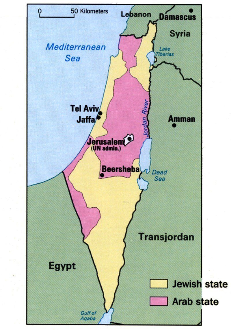
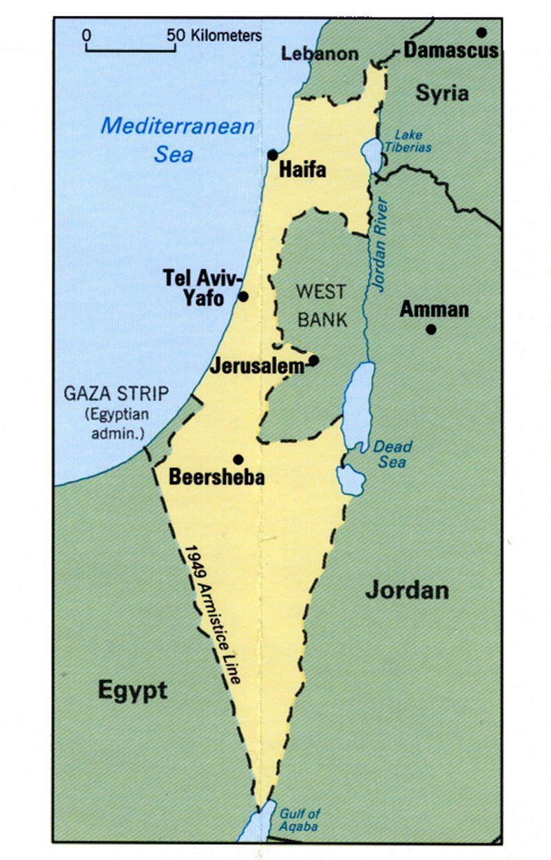
Bibliography
|
|