Jiasian District: Difference between revisions
| other_name = Jiaxian attempted correction of "https://en.wikipedia.org/w/index.php?title=Jiasian_District&diff=prev&oldid=773787579" |
|||
| Line 6: | Line 6: | ||
| native_name = {{nobold|甲仙區}} |
| native_name = {{nobold|甲仙區}} |
||
| native_name_lang = zh-hant |
| native_name_lang = zh-hant |
||
| other_name = |
| other_name = Jiaxian |
||
| settlement_type = [[District (Taiwan)|District]]<!-- such as Town, Village, City, Borough etc. --> |
| settlement_type = [[District (Taiwan)|District]]<!-- such as Town, Village, City, Borough etc. --> |
||
| translit_lang1 = |
| translit_lang1 = |
||
Revision as of 23:32, 29 July 2019
23°05′N 120°35′E / 23.083°N 120.583°E
Jiasian
甲仙區 Jiaxian | |
|---|---|
| Jiasian District[1] | |
 | |
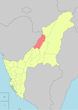
 Jiasian District in Kaohsiung City | |
| Country | Taiwan |
| Region | Southern Taiwan |
| Population (January 2016) | |
| • Total | 6,252 |
| Website | Official Website Template:Zh icon |
Jiasian District[1][2][3][4][5] (Chinese: 甲仙區; Hanyu Pinyin: Jiǎxiān Qū; Tongyong Pinyin: Jiǎsian Cyu; Wade–Giles: Chia3-hsien1 Ch'ü1) is a rural district in Kaohsiung City, Taiwan. Located far from the coast, the township is regarded as a gateway to Taiwan's Central Mountain Range.
Situated at the intersection of Highway 20 (the Southern Cross-Island Highway) and Highway 21, Jiasian's downtown serves as a market center for local farmers and tourists. The most famous local crop is taro. Shops sell taro-flavored ice cream, taro cookies, and other taro products. The township is also known for its bamboo shoots and plums.[6]
Jiasian Bridge was torn down by rushing waters during Typhoon Morakot in August 2009. It was rebuilt with a budget of NT$560 million and re-opened in June 2010.[6] The new bridge is 300 metres (980 feet) long and 21 metres (69 feet) wide, and is installed with a lighting system.[6]
Geography
- Area: 124.03 km²
- Population: 6,252 people (January 2016)
Much of the township is between 200 and 500 metres (660 and 1,640 feet) above sea level.
Villages
- Baolong Village (寶隆里)
- Datian Village (大田里)
- Dong'an Village (東安里)
- Guanshan Village
- He'an Village (和安里)
- Xi'an Village (西安里)
- Siaolin Village (Xiaolin)
In Taiwan, "village" (里) is a level of administrative division that under a rural township. The main town of Jiasian is divided into three villages: Dong'an, Xi'an, and He'an.
Tourist attractions
- Cemetery of Zhenghaijun
- Jiaxian Bridge
- Jiasianpu Memorial Monument
- Jiasian Water Park
- Jiasian Petrified Fossil Museum
- Mount Baiyun
- Mount Liouyi
- Mount Neiying
- Mount Waiying
- Mount Zion (Chinese: 錫安山; pinyin: Xí'an Shan),[7] a Christian hamlet.
- Xiaolin Village Memorial Park
Transportation

Bus station in the district is Jiaxian Station of Kaohsiung Bus.
See also
References
- ^ a b "Administrative Districts". 高雄市政府. 30 September 2016. Retrieved 4 April 2017.
Jiasian District:
- ^ "About Jiasian". Jiasian Distrct Office. Retrieved 29 July 2019.
Jiasian Township is located at the northeast end of Kaohsiung County,{...}Address: No.50, Jhongshan Rd., Jiasian District, Kaohsiung City 84742, Taiwan (R.O.C.)
- ^ Jiasian (Variant - V) at GEOnet Names Server, United States National Geospatial-Intelligence Agency
- ^ Eryk Smith (22 January 2018). "OPINION: Should Kaohsiung Spend US$100M Repairing Rural Roads?". The News Lens. Retrieved 29 July 2019.
the Aug. 8, 2009, series of mudslides and floods triggered by Typhoon Morakot that buried alive at least 400 souls in Jiasian (甲仙區) District's Siaolin Village (小林村).
- ^ "Bed-load monitoring via Japanese pipe-hydrophone- case study in Kaohsiung, Taiwan". SAO/NASA Astrophysics Data System. April 2018. Retrieved 29 July 2019.
The study area of this paper is located in Yokaung River, a mountain torrent in Kaohsiung city, Jiasian District.
{{cite web}}: Unknown parameter|authors=ignored (help) - ^ a b c "Kaohsiung's Jiaxian Bridge opens to bring tourists back". Taiwan News. 2010-06-27. Retrieved 2010-07-09.
- ^ "錫安山" ("Mt. Zion") atlaspost.com, in Chinese
