
Andhra Pradesh Capital Region: Difference between revisions
Citation bot (talk | contribs) Alter: title. Removed parameters. | Use this bot. Report bugs. | Suggested by Abductive | #UCB_webform 2372/3849 |
Horologium (talk | contribs) Populated->populous. Tags: Mobile edit Mobile web edit |
||
| Line 113: | Line 113: | ||
}} |
}} |
||
'''Andhra Pradesh Capital Region''' is the [[metropolitan region]] area of Andhra Pradesh state capital, the defacto capital city of [[Andhra Pradesh]]. Vijayawada is the headquarters and the largest city of the region. It includes the major ancient cities of [[Vijayawada]], [[Guntur]], and [[Tenali]]. Andhra Pradesh Capital Region is one of the largest populated urban areas in the world, with its suburbs Vijayawada, Guntur, and Tenali being the 3rd, 24th, 41st most densely populated cities in the world. Vijayawada is the most densely populated city in India while Guntur is 11th and Tenali is the most |
'''Andhra Pradesh Capital Region''' is the [[metropolitan region]] area of Andhra Pradesh state capital, the defacto capital city of [[Andhra Pradesh]]. Vijayawada is the headquarters and the largest city of the region. It includes the major ancient cities of [[Vijayawada]], [[Guntur]], and [[Tenali]]. Andhra Pradesh Capital Region is one of the largest populated urban areas in the world, with its suburbs Vijayawada, Guntur, and Tenali being the 3rd, 24th, 41st most densely populated cities in the world. Vijayawada is the most densely populated city in India while Guntur is 11th and Tenali is the most populous city of 14th place in Andhra Pradesh.<ref>{{Cite web|url=http://www.deccanchronicle.com/nation/current-affairs/190816/vijayawada-is-third-densely-packed-city-31200-people-in-every-square-km.html|title=Vijayawada is third densely packed city; 31,200 people in every square km|first=u sudhakar|last=reddy|date=19 August 2016|website=Deccan Chronicle}}</ref> Andhra Pradesh Capital Region is the most populated metropolitan area in the state of [[Andhra Pradesh]] and 8th in India. Entire region is under the jurisdiction of [[Andhra Pradesh Capital Region Development Authority]], and covers an area of {{convert|8603|sqkm|abbr=on}} under 58 [[mandal]]s, of which 29 are in [[Krishna district]] and 29 in [[Guntur district]].<ref name="crda">{{cite web|title=A.P. Capital Region|url=http://www.crda.ap.gov.in/APCRDADOCS/DataModuleFIles/FACTS%20AND%20FIGURES%20OF%20CAPITAL%20REGION/01~1117CRDA%20Factfile%20(%20Web%20view).pdf|website=APCRDA|publisher=Government of Andhra Pradesh|access-date=1 September 2016|page=15|archive-url=https://web.archive.org/web/20160913124145/http://www.crda.ap.gov.in/APCRDADOCS/DataModuleFIles/FACTS%20AND%20FIGURES%20OF%20CAPITAL%20REGION/01~1117CRDA%20Factfile%20(%20Web%20view).pdf |archive-date=13 September 2016}}</ref> The capital region covers 18 mandals fully and 11 mandals partially in [[Guntur district]]. In [[Krishna district]], it covers 15 mandals fully and 14 mandals partially under the jurisdiction of APCRDA.<ref>{{cite news|title=AP Capital Region Development Authority comes into being|url=http://www.thehindu.com/news/cities/Vijayawada/ap-capital-region-development-authority-comes-into-being/article6739396.ece|access-date=6 January 2015|work=The Hindu|date=31 December 2014|location=Hyderabad}}</ref><ref name="mandals">{{cite web|title=District wise mandals and villages covered in Krishna and Guntur districts |url=http://crda.ap.gov.in/APCRDA/Downloads/Notifications/2014MAUD_MS253.PDF |website=Andhra Pradesh Capital Region Development Authority |publisher=Government of Andhra Pradesh |access-date=23 September 2015 |url-status=dead|archive-url=https://web.archive.org/web/20150923135735/http://crda.ap.gov.in/APCRDA/Downloads/Notifications/2014MAUD_MS253.PDF |archive-date=23 September 2015 }}</ref> The capital city is an Urban Notified Area, and will cover {{Convert|217.23|km2|mi2|abbr=on}}, within the Andhra Pradesh Capital Region.<ref>{{cite news|last1=Mahalakshmi|first1=BV|title=Foundation stone of Andhra Pradesh's new capital Amaravati laid by PM Narendra Modi|url=http://www.financialexpress.com/article/economy/pm-narendra-modi-lays-foundation-stone-for-andhra-pradeshs-new-capital-amaravati/155133/|access-date=5 June 2016|work=The Financial Express|date=22 October 2015|archive-url=https://web.archive.org/web/20160701074811/http://www.financialexpress.com/article/economy/pm-narendra-modi-lays-foundation-stone-for-andhra-pradeshs-new-capital-amaravati/155133/|archive-date=1 July 2016|url-status=dead|df=dmy-all}}</ref> As of 1 August 2020, Andhra Pradesh proposed three capitals, which are [[Visakhapatnam]] as the executive capital, [[Amaravati]] as the legislative capital, and [[Kurnool]] as the judicial capital, but the process was cancelled and reverted back to the original 2014 plan of a singular capital city at Amaravati on 22 November 2021.<ref>{{cite web |title=High court extends status quo on three capitals |url=https://www.tribuneindia.com/news/nation/andhra-hc-extends-status-quo-on-three-capitals-row-till-october-5-144512}}</ref> |
||
== Administration == |
== Administration == |
||
Revision as of 22:32, 29 December 2022
Andhra Pradesh Capital Region | |
|---|---|
 Map showing Andhra Pradesh Capital Region spread across Guntur and Krishna districts with the city of Amaravati on the banks of River Krishna | |
 Seal | |
| Country | |
| State | Andhra Pradesh |
| Districts | NTR District Guntur district Krishna district |
| Head quarters | Vijayawada |
| Area | |
| • Total | 8,603 km2 (3,322 sq mi) |
| Population (2011)[1] | |
| • Total | 5,873,588 |
| • Density | 680/km2 (1,800/sq mi) |
| Time zone | UTC+5:30 (Indian Standard Time) |
| • Summer (DST) | UTC+5:30 (Indian Standard Time) |
| Website | APCRDA |
Andhra Pradesh Capital Region is the metropolitan region area of Andhra Pradesh state capital, the defacto capital city of Andhra Pradesh. Vijayawada is the headquarters and the largest city of the region. It includes the major ancient cities of Vijayawada, Guntur, and Tenali. Andhra Pradesh Capital Region is one of the largest populated urban areas in the world, with its suburbs Vijayawada, Guntur, and Tenali being the 3rd, 24th, 41st most densely populated cities in the world. Vijayawada is the most densely populated city in India while Guntur is 11th and Tenali is the most populous city of 14th place in Andhra Pradesh.[2] Andhra Pradesh Capital Region is the most populated metropolitan area in the state of Andhra Pradesh and 8th in India. Entire region is under the jurisdiction of Andhra Pradesh Capital Region Development Authority, and covers an area of 8,603 km2 (3,322 sq mi) under 58 mandals, of which 29 are in Krishna district and 29 in Guntur district.[3] The capital region covers 18 mandals fully and 11 mandals partially in Guntur district. In Krishna district, it covers 15 mandals fully and 14 mandals partially under the jurisdiction of APCRDA.[4][5] The capital city is an Urban Notified Area, and will cover 217.23 km2 (83.87 sq mi), within the Andhra Pradesh Capital Region.[6] As of 1 August 2020, Andhra Pradesh proposed three capitals, which are Visakhapatnam as the executive capital, Amaravati as the legislative capital, and Kurnool as the judicial capital, but the process was cancelled and reverted back to the original 2014 plan of a singular capital city at Amaravati on 22 November 2021.[7]
Administration
.JPG)

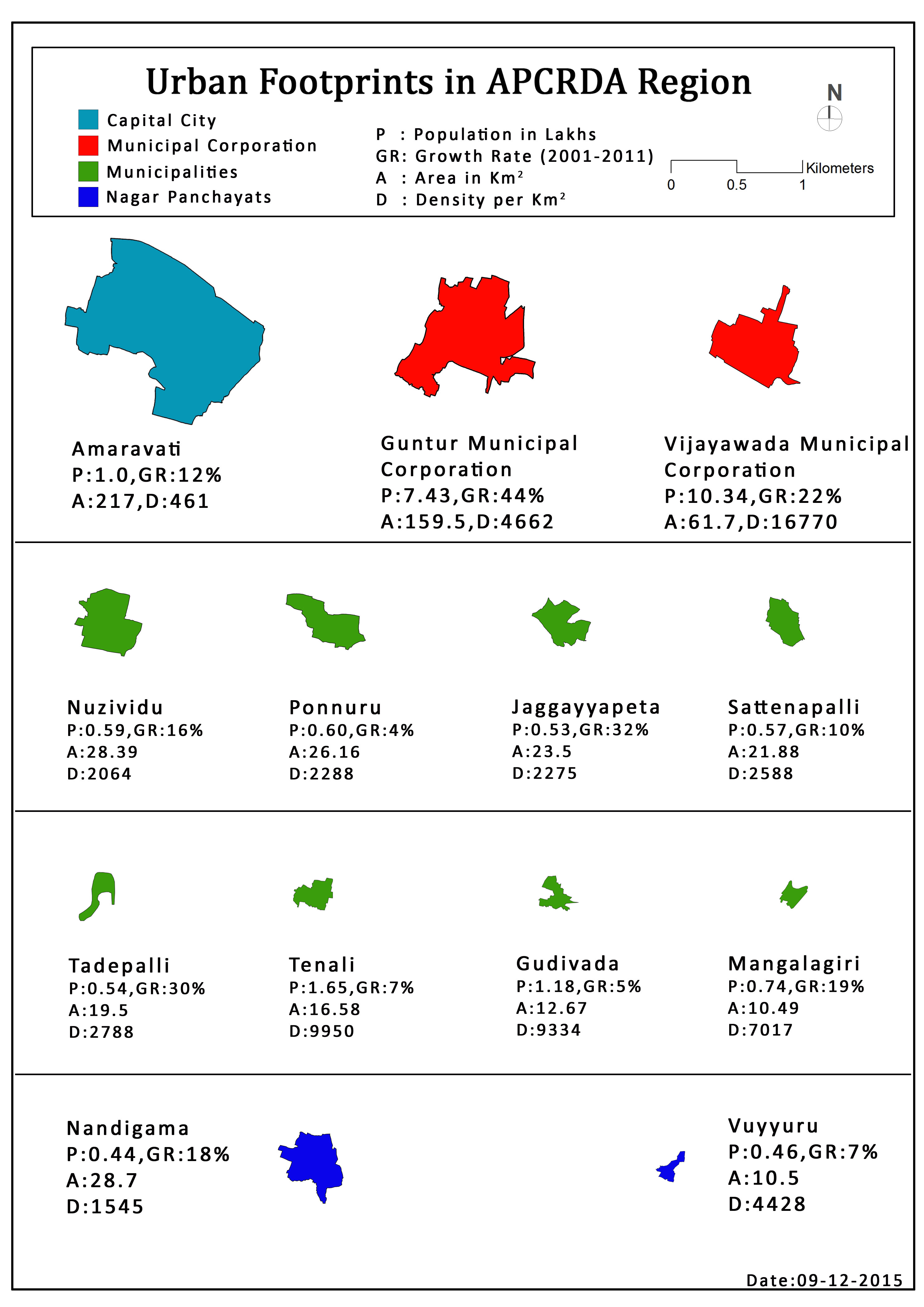
Urban local bodies
The region has a total of 13 urban areas including the capital city of Amaravati, 3 municipal corporations, 10 municipalities. Vijayawada, Guntur, Tenali are the three municipal corporations, Gudivada, Jaggayyapeta, Mangalagiri, Nuzvid, Ponnur, Sattenapalle, Tadepalle, Nandigama, Vuyyuru and YSR Tadigadapa are the municipalities.[8]
Jurisdiction
The below is the list of mandals and villages under the jurisdiction of Andhra Pradesh Capital Region Development Authority.[5][9][10]
| Fully included mandals | |||
|---|---|---|---|
| # | Guntur district | # | Krishna district |
| 1 | Amaravati mandal | 1 | Agiripalle mandal |
| 2 | Amruthaluru mandal | 2 | G. Konduru mandal |
| 3 | Chebrolu mandal | 3 | Gannavaram mandal |
| 4 | Duggirala mandal | 4 | Ibrahimpatnam mandal |
| 5 | Guntur mandal | 5 | Kanchikacharla mandal |
| 6 | Kollipara mandal | 6 | Kankipadu mandal |
| 7 | Kollur mandal | 7 | Mylavaram mandal |
| 8 | Mangalagiri mandal | 8 | Pamidimukkala mandal |
| 9 | Medikonduru mandal | 9 | Pedaparupudi mandal |
| 10 | Pedakakani mandal | 10 | Penamaluru mandal |
| 11 | Pedakurapadu mandal | 11 | Thotlavalluru mandal |
| 12 | Tadikonda mandal | 12 | Unguturu mandal |
| 13 | Tadepalle mandal | 13 | Veerullapadu mandal |
| 14 | Tenali mandal | 14 | Vijayawada (rural) mandal |
| 15 | Thullur mandal | 15 | Vijayawada (urban) mandal |
| 16 | Tsunduru mandal | 16 | Vuyyuru mandal |
| 17 | Vatticherukuru mandal | 17 | |
| 18 | Vemuru mandal | 18 | |
Partially included mandals/villages
The limits of the region was expanded on 22 September 2015, which resulted in addition and removal of the mandals and villages.[5][9]
Mandals in the below list are the partially included (only some villages) in the capital region.
Guntur district
| Guntur district | |||
|---|---|---|---|
| # | Name of mandal | Villages | No. of villages |
| 1 | Atchampeta mandal | Ambadipudi, Challagariga, Chamarru (including Atchampet, Neeleswarapalem Grampanchayats), Chigurupadu, Chintapalle, Ginjupalle, Kastala Agraharam, Konuru, Kogantivaripalem, Madipadu Agraharam, Madipadu Seri, Mittapalem, Orvakallu, Pedapalem, Taduvoy, Thallacheruvu, Velpuru | 18 |
| 2 | Bhattiprolu mandal | Bhattiprolu (including Addepalli), Gorigapudi, Konetipuram, Oleru, Pallekona, Pedalanka, Pedapulivarru, Pesarlanka, Sivangulapalem, Surepalle, Vellaturu | 11 |
| 3 | Krosuru mandal | Ananthavaram Agraharam, Andukuru, Balemarru, Bayyavaram, Dodleru, Garikapadu, Gudipadu, Hassanbada, Krosuru, Parupalle, Peesapadu, Thalluru, Vipparla, Vutukuru, Vuyyandana | 15 |
| 4 | Phirangipuram mandal | Aminabad, Bethapudi, Erraguntlapadu, Gundlapadu, Havusu Ganesha, Merikapudi, Nudurupadu, Phirangipuram, Ponugupadu, Repudi, Sirangipalem, Takkellapadu, Thalluru, Vemavaram | 14 |
| 5 | Ponnur mandal | Aremanda, Brahmana Koduru, Chintalapudi, Dandamudi, Doppalapudi, Jadavalli, Jupudi, Kondamudi, Mannava, Mamillapalle, Mulukuduru, Munipalle, Nandur, Nidubrolu, Patchalatadiparru, Upparapalem, Vaddimukkala, Vallabharaopale, Vellaluru | 19 |
| 6 | Prattipadu mandal | Edulapalem, Enamadala, Ganikapudi, Gottipadu, Konda Jagarlamudi, Kondapadu, Mallayapalem, Nadimpalem, Prattipadu, Vangipuram | 10 |
| 7 | Sattenapalli mandal | Abburu, Bhatluru, Bhimavaram, Bhurugubanda, Dhulipalla, Garlapadu, Gorantla, Gudipudi, Kankanalapalle, Kantepudi, Kattamuru, Komerapudi, Lakkaraju Garlapadu, Nandigama, Pakalapadu, Panidem, Pedamakkena, Rentapalla, Vaddavalli | 18 |
| 8 | Edlapadu mandal | Edlapadu, Jaladi, Karuchola, Khandrika, Kondaveedu, Marripalem, Mydavolu, Sandepudi, Solasa, Thimmapuram, Thurlapadu Unnava, Vankayalapadu, Viswanadhuni | 13 |
Krishna district
| Krishna district | |||
|---|---|---|---|
| # | Name of mandal | Villages | No. of villages |
| 1 | Bapulapadu mandal | Ampapuram, Arugolanu, Bandarugudem, Bapulapadu, Billanapalle, Bommuluru, Bommuluru Khandrika, Chirivada, Dantaguntla, Kakulapadu, Kanumolu, Kodurupadu, Kothapalle, Koyyuru, Kuripirala, Madicherla, Mallavalli, Ogirala, Ramannagudem, Rangannagudem, Remalle, Seri Narasannapalem, Singannagudem, Sobhanadri puram, Tippanagunta, Veeravalle, Veleru, Venkatapuram, Venkataraju Gudem | 29 |
| 2 | Challapalle mandal | Challapalle, Chidepudi, Lakshmipuram, Majeru, Mangalapuram, Nadakuduru, Nimmagadda, Pagolu, Puritigadda, Vakkalagadda, Velivolu, Yarlagadda | 12 |
| 3 | Chandarlapadu mandal | Bobbellapadu, Brahmabotlapalem, Chandarlapadu, Chintalapadu, Eturu, Gudimetla, Gudimetlapalem, Kasarabada, Kodavatikallu, Konayapalem, Medipalem, Munagalapalle, Muppala, Patempadu, Pokkunuru, Popuru, Punnavalle, Thotaravulapadu, Turlapadu, Ustepalle, Veladi, Vibhareetapadu | 23 |
| 4 | Ghantasala mandal | Birudugadda, Bollapadu, Chilakalapudi, Chinakallepalle, Chitturpu, Daliparru, Devarakota, Elikalakuduru, Endakuduru, Ghantasala, Kodali, Kothapalle, Lankapalle, Mallampalle, Pushadam, Srikakulam, Tadepalle, Telugurao Palem, Vellimalli Rudravaram, Vemulapalle | 20 |
| 5 | Gudivada mandal | Allidoddi, Bethavolu, Billapadu, Bomuluru, Chilakamudi, China Yerukapadu, Chirichintala, Chowtapalle, Dondapadu, Gangadharapuram, Gudivada (R), Guntakoduru, Kalvapudiagraharam, Lingavaram, Mandapadu, Merakagudem, Moturu, Nagavarappadu, Peda Yerakapadu, Ramachandrapuram, Ramanapudi, Saidepudi, Seepudi, Seri Dintakurru, Serigolvepalli, Serivelpuru, Siddantam, Tativarru, Valivartipadu | 29 |
| 6 | Jaggayyapeta mandal | Annavaram, Anumanchipalle, Balusupadu, Bandipalem, Buchavaram, Budawada, Chillakallu, Gandrai, Garikapadu, Gowravaram, Jayanthipuram, Kowthavariagraharam, Malkapuram, Muktheswarapuram, Pochampalle, Ramachandrunipeta, Ravikmapadu, Ravirala, Shermohammadpeta, Thakkellapadu, Tirumalagiri, Torraguntapalem, Tripuravaram, Vedadri | 24 |
| 7 | Mopidevi mandal | Annavaram, Ayodhya, Bobbarlanka, Chiruvolu, Kaptanpalem, Kokkilagadda, Mellamarru, Mellamarthilanka, Merakanapalli, Mopidevi, Mopidevi lanka, Nagayatippa, Pedakallepalli, Pedaprolu, Tekupalli, Venkatapuram | 15 |
| 8 | Movva mandal | Avurupudi, Ayyanki, Barlapudi, Bhatla Penumarru, Chinamuttevi, Gudapadu, Kaza, Kosuru, Kuchipudi, Movva, Nidumolu, Palankipadu, Pedapudi, Pedasanagallu, Pedamuttevi, Vemulamada, Yeddanapudi | 17 |
| 9 | Mylavaram mandal | Chandragudem, Chandrala, Dasullapalem, Ganapavaram, Gannavaram, Gudem, Janagalapalle, Kanimerla, Keerthirayuni gudem, Morusumilli, Mulakalapenta Mylavaram, Parvathapuram, Pondugula, Pulluru, Sabjapadu, Tholukodu, Thummalagunta, Vedurubeedem, Velvadam | 18 |
| 11 | Nandigama mandal | Adaviravulapadu, Lingalapadu, Aitavaram, Ambarupeta, Chandapuram, Damuluru, Gollamudi, Jonnalagadda, Torragudipadu, Kanchala, Kethaveerunipadu, Konatham Atmakuru, Konduru, Kurugantivari Khandrika, Latchapalem, Magallu, Munagacharla, Pallagiri, Pedavaram, Raghavapuram, Ramireddipalle, Rudravaram, Satyavaram, Somavaram, Takkellapadu | 25 |
| 12 | Nandivada mandal | Anamanapudi, Aripirala, Chedurtipadu, Chinalingala, Dandiganapudi, Gandepudi, Ilaparru, Janardhanapuram, Kudaravalli, Nandivada, Nuthulapadu, Puttagunta, Oddulameraka, Pedalingala, Pedavirivada, Polukonda, Ramapuram, Rudrapaka, Srinivasapuram, Tamirisa, Tummalapalle, Vennanapudi | 22 |
| 13 | Nuzvid mandal | ||
| 14 | Pamarru mandal | ||
| 15 | Penuganchiprolu mandal | ||
| 16 | Vatsavai mandal | ||
| 17 | Avanigadda | ||
Municipal Corporations
• Vijayawada Municipal Corporation
• Guntur Municipal Corporation
• Mangalagiri Tadepalli Municipal Corporation
Municipalities
• YSR Tadigadapa
• Kondapalli
• Tenali
Census Towns and other Neighbourhoods
See also
References
- ^ "Demography" (PDF). APCRDA. Government of Andhra Pradesh. Retrieved 30 June 2016.
- ^ reddy, u sudhakar (19 August 2016). "Vijayawada is third densely packed city; 31,200 people in every square km". Deccan Chronicle.
- ^ "A.P. Capital Region" (PDF). APCRDA. Government of Andhra Pradesh. p. 15. Archived from the original (PDF) on 13 September 2016. Retrieved 1 September 2016.
- ^ "AP Capital Region Development Authority comes into being". The Hindu. Hyderabad. 31 December 2014. Retrieved 6 January 2015.
- ^ a b c "District wise mandals and villages covered in Krishna and Guntur districts" (PDF). Andhra Pradesh Capital Region Development Authority. Government of Andhra Pradesh. Archived from the original (PDF) on 23 September 2015. Retrieved 23 September 2015.
- ^ Mahalakshmi, BV (22 October 2015). "Foundation stone of Andhra Pradesh's new capital Amaravati laid by PM Narendra Modi". The Financial Express. Archived from the original on 1 July 2016. Retrieved 5 June 2016.
- ^ "High court extends status quo on three capitals".
- ^ "Urban Footprints in APCRDA Region". APCRDA. Retrieved 27 June 2016.
- ^ a b "Declaration of A.P. Capital Region" (PDF). APCRDA. Municipal Administration and Urban Development Department. 22 September 2015. Archived from the original (PDF) on 21 February 2016. Retrieved 21 February 2016.
- ^ Subba Rao, GVR (23 September 2015). "Capital region expands as CRDA redraws boundaries". The Hindu. Vijayawada. Retrieved 31 October 2015.