
Pikes Peak: Difference between revisions
m Template:Weather box soon to display metric units first by default, replaced: km → |km|abbr=on}} (2), = Yes → = Y, replaced: F = - → F = − (5), single line = Y → single line = Y |imperial first = Y using AWB |
|||
| Line 98: | Line 98: | ||
The most popular hiking route to the top is called [[Barr Trail]], which approaches the summit from the east. The trailhead is just past the cog railway depot in Manitou Springs. Visitors can walk, hike, or bike the trail. Runners race to the top and back on Barr Trail in the annual [[Pikes Peak Marathon]]. Another route begins at Crags Campground, approaching the summit from the west.<ref>[http://www.14ers.com/routeprt.php?route=pike1&peak=Pikes%20Peak 14ers.com]</ref><ref>[http://www.onedayhikes.com/Hikes.asp?HikesID=154 OneDayHikes.com]</ref> |
The most popular hiking route to the top is called [[Barr Trail]], which approaches the summit from the east. The trailhead is just past the cog railway depot in Manitou Springs. Visitors can walk, hike, or bike the trail. Runners race to the top and back on Barr Trail in the annual [[Pikes Peak Marathon]]. Another route begins at Crags Campground, approaching the summit from the west.<ref>[http://www.14ers.com/routeprt.php?route=pike1&peak=Pikes%20Peak 14ers.com]</ref><ref>[http://www.onedayhikes.com/Hikes.asp?HikesID=154 OneDayHikes.com]</ref> |
||
At the peak, the [[partial pressure]] of oxygen is only 60% of that at sea level, so a faster rate of respiration is required by those not regularly at high altitudes. Those familiar with [[altitude training]] know that prolonged exposure to the reduced pressures of high altitudes will produce more [[red blood cells]] to offset the lower oxygen availability. For the unacclimated, [[altitude sickness]] may develop in those who are sensitive or who over-exert themselves. |
At the peak, the [[partial pressure]] of oxygen is only 60% of that at sea level{{cn}}, so a faster rate of respiration is required by those not regularly at high altitudes. Those familiar with [[altitude training]] know that prolonged exposure to the reduced pressures of high altitudes will produce more [[red blood cells]] to offset the lower oxygen availability. For the unacclimated, [[altitude sickness]] may develop in those who are sensitive or who over-exert themselves. |
||
Conditions at the top are typical of a high alpine environment. Snow is a possibility any time year-round, and thunderstorms are common in the summer. |
Conditions at the top are typical of a high alpine environment{{cn}}. Snow is a possibility any time year-round{{cn}}, and thunderstorms are common in the summer. |
||
Since 1969, the summit of Pikes Peak has been the site of the [[United States Army Pike’s Peak Research Laboratory]], a medical research laboratory for the assessment of the impact of high altitude on human physiological and medical parameters of military interest. |
Since 1969, the summit of Pikes Peak has been the site of the [[United States Army Pike’s Peak Research Laboratory]], a medical research laboratory for the assessment of the impact of high altitude on human physiological and medical parameters of military interest. |
||
Revision as of 21:26, 24 April 2013
| Pikes Peak | |
|---|---|
 Pikes Peak, Colorado | |
| Highest point | |
| Elevation | 14,115 ft (4,302 m) NAVD 88[1] |
| Prominence | 5,510 ft (1,680 m)[2] |
| Listing | Ultra Colorado Fourteener |
| Geography | |
 Pikes Peak Colorado | |
| Location | El Paso County, Colorado, USA near Colorado Springs |
| Parent range | Front Range |
| Topo map | USGS Pikes Peak |
| Geology | |
| Age of rock | ~ 1.05 Gyr |
| Mountain type | granite |
| Climbing | |
| First ascent | 1820 — Edwin James and party |
| Easiest route | Barr Trail Automobile Pike's Peak Railway |
Pikes Peak (originally Pike's Peak) is a mountain in the Front Range of the Rocky Mountains within Pike National Forest, 10 mi (16 km) west of Colorado Springs, Colorado, in El Paso County in the United States of America.
Originally called "El Capitán" by Spanish settlers, the mountain was renamed Pike's Peak after Zebulon Pike, Jr., an explorer who led an expedition to the southern Colorado area in 1806. The Arapaho name is heey-otoyoo’ ("long mountain").[3]
At 14,115 feet (4,302 m),[1] it is one of Colorado's 54 fourteeners, mountains that rise more than 14,000 feet (4,300 m) above mean sea level, and rises 8,400 feet (2,600 m) above the city of Colorado Springs. Pikes Peak is a designated National Historic Landmark.
Geography and geology
Pikes Peak is the easternmost fourteen thousand foot peak in the United States, located 10 miles (16 km) west of the city of Colorado Springs.
Pikes Peak is composed of a characteristic pink granite called Pikes Peak granite. The color is due to a large amount of potassium feldspar. It is theorized that the granite was once magma that crystallized at least 20 miles (32 km) beneath the Earth's surface, formed by an igneous intrusion during the Precambrian, approximately 1.05 billion years ago, during the Grenville orogeny. Through the process of uplifting, the hardened rock pushed through the Earth's crust and created a dome-like mountain, covered with less resistant rock. Years of erosion and weathering removed the soil and rock leaving the exposed mountain.
Discovery
The first American sighting is often credited to members of the Pike expedition, led by Zebulon Pike. After a failed attempt to climb to the top in November 1806, Pike wrote in his journal:
- "...here we found the snow middle deep; no sign of beast or bird inhabiting this region. The thermometer which stood at 9° above 0 at the foot of the mountain, here fell to 4° below 0. The summit of the Grand Peak, which was entirely bare of vegetation and covered with snow, now appeared at the distance of 15 or 16 miles (24 or 26 km) from us, and as high again as what we had ascended, and would have taken a whole day's march to have arrived at its base, when I believed no human being could have ascended to its pinical [sic]. This with the condition of my soldiers who had only light overalls on, and no stockings, and every way ill provided to endure the inclemency of the region; the bad prospect of killing any thing to subsist on, with the further detention of two or three days, which it must occasion, determined us to return."[4]
History


The first European-American to climb the peak came 14 years after Pike in the summer of 1820. Edwin James, a young student who had just graduated from Middlebury College in Vermont, signed on as the relief botanist for the Long Expedition after the first botanist had died. The expedition explored the South Platte River up as far as present-day Denver, then turned south and passed close to what James called "Pike's highest peak." James and two other men left the expedition, camped on the plains, and climbed the peak in two days, encountering little difficulty. Along the way, he was the first to describe the blue columbine, Colorado's state flower.
Gold was discovered in the area of present-day Denver in 1858, and newspapers referred to the gold-mining area as "Pike's Peak." Pike's Peak or Bust became the slogan of the Colorado Gold Rush (see also Fifty-Niner). This was more due to Pikes Peak's visibility to gold seekers traveling west across the plains than any actual significant gold find anywhere near Pikes Peak. Major gold deposits were not discovered in the Pikes Peak area until the Cripple Creek Mining District was discovered southwest of Pikes Peak, and led in 1893 to one of the last major gold rushes in the lower forty-eight states.
In July 1860, Clark, Gruber and Company commenced minting gold coins in Denver bearing the phrase "Pike's Peak Gold" and an artist's rendering of the peak (site unseen) on the obverse. In 1863 the U.S. Treasury purchased the minting equipment for $25,000 to open the Denver Mint.
In July 1893, Katharine Lee Bates wrote the song "America the Beautiful", after having admired the view from the top of Pikes Peak. It appeared in print in The Congregationalist, a weekly journal, on July 4, 1895. A plaque commemorating the words to the song was placed at the summit.
On July 17, 1913 William Wayne Brown drove his car, the Bear Cat, twenty miles to the summit.[5][6] The ascent took 5 hours and 28 minutes.
The uppermost portion of Pikes Peak, above 14,000 feet (4,300 m) elevation, was declared a National Historic Landmark in 1961.[7][8]
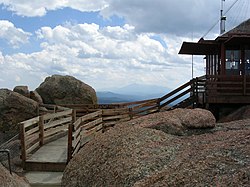
Pikes Peak today


There are several visitor centers on Pikes Peak, some with a gift shop and restaurant. These centers are located at 6 mile, 12-mile (19 km) and the summit itself, and there are several ways to ascend the mountain. The Manitou and Pike's Peak Railway is a cog railroad operating from Manitou Springs to the summit year-round, conditions permitting. Automobiles can be driven to the summit via the Pikes Peak Highway, a 19 mi (31 km) road that starts a few miles up Ute Pass at Cascade. This road, which until October 2011 was unpaved after the halfway point, was made famous worldwide by the short film Climb Dance featuring Ari Vatanen racing his Peugeot automobile up the steep, twisty slopes as part of the annual Pikes Peak International Hill Climb race. The road has a series of switchbacks, treacherous at high speed, called "The W's" for their shape on the side of the mountain. The road is maintained by the city of Colorado Springs as a toll road.
A project to pave the remainder of the road was completed on October 1, 2011.[9] The project is in response to a suit by the Sierra Club over damage caused by the gravel and sediment that is constantly washed off the road into the alpine environment.[10][11] The road remained open during construction.
The most popular hiking route to the top is called Barr Trail, which approaches the summit from the east. The trailhead is just past the cog railway depot in Manitou Springs. Visitors can walk, hike, or bike the trail. Runners race to the top and back on Barr Trail in the annual Pikes Peak Marathon. Another route begins at Crags Campground, approaching the summit from the west.[12][13]
At the peak, the partial pressure of oxygen is only 60% of that at sea level[citation needed], so a faster rate of respiration is required by those not regularly at high altitudes. Those familiar with altitude training know that prolonged exposure to the reduced pressures of high altitudes will produce more red blood cells to offset the lower oxygen availability. For the unacclimated, altitude sickness may develop in those who are sensitive or who over-exert themselves.
Conditions at the top are typical of a high alpine environment[citation needed]. Snow is a possibility any time year-round[citation needed], and thunderstorms are common in the summer. Since 1969, the summit of Pikes Peak has been the site of the United States Army Pike’s Peak Research Laboratory, a medical research laboratory for the assessment of the impact of high altitude on human physiological and medical parameters of military interest.
Pikes Peak was the home of a ski resort from 1939 until 1984.[14]
The mountain is also the site of the annual Pikes Peak International Hill Climb and Pikes Peak Ascent and Marathon foot races on Barr Trail.
Climate
| Climate data for Pikes Peak summit. (Elevation 14,115ft) | |||||||||||||
|---|---|---|---|---|---|---|---|---|---|---|---|---|---|
| Month | Jan | Feb | Mar | Apr | May | Jun | Jul | Aug | Sep | Oct | Nov | Dec | Year |
| Mean daily maximum °F (°C) | 8.1 (−13.3) |
10.6 (−11.9) |
14.0 (−10.0) |
19.7 (−6.8) |
28.4 (−2.0) |
38.5 (3.6) |
47.6 (8.7) |
48.1 (8.9) |
39.2 (4.0) |
28.4 (−2.0) |
16.0 (−8.9) |
10.7 (−11.8) |
25.8 (−3.4) |
| Mean daily minimum °F (°C) | −3.7 (−19.8) |
−2.9 (−19.4) |
−0.8 (−18.2) |
4.6 (−15.2) |
14.3 (−9.8) |
24.6 (−4.1) |
33.7 (0.9) |
32.9 (0.5) |
24.3 (−4.3) |
14.2 (−9.9) |
3.9 (−15.6) |
−2.7 (−19.3) |
11.9 (−11.2) |
| Source: summitpost.org[15] | |||||||||||||
See also
- Outline of Colorado
- Index of Colorado-related articles
- Geology of the Rocky Mountains
- Mountain ranges of the world
- Rocky Mountains
- Southern Rocky Mountains
- Mountain ranges of Colorado
- Front Range
- Pikes Peak Massif
- Front Range
- Rocky Mountains
- List of Ultras of North America
- Mountain peaks of North America
See also
References
- ^ a b c "NGS Data Sheet for Pikes Peak". National Geodetic Survey.
- ^ "Pikes Peak, Colorado". Peakbagger.com. Retrieved 2011-02-22.
- ^ "Arapaho Place Names". Arapaho Language Archives, University of Colorado at Boulder. Retrieved 2012-07-18.
- ^ Pike, Zebulon M. (1810). An Account of Expeditions to the Sources of the Mississippi. ISBN 0-665-46872-5.
{{cite book}}: Cite has empty unknown parameter:|month=(help) - ^ "Up Pikes Peak by Auto". Technical world magazine. Armour Institute of Technology. 1913. Retrieved 2012-10-04.
... has safely withstood the assaults of automobiles, until July 17, 1913, when W. W. Brown, a racing driver from Kansas City, drove a machine, termed by himself the "Bear Cat", up the slopes of the Peak, a distance of twenty miles.
{{cite news}}: Cite has empty unknown parameter:|coauthors=(help) - ^ "William Wayne "W. W." Brown a.k.a. "Cockeyed" Brown (1886-1958)". Retrieved 2012-10-04.
This photograph of W. W. Brown was taken on July 17, 1913 as he drove his Model 10 Buick "Bearcat" up Pikes Peak in Colorado. He had raced the car in Winfield, Kansas just 13 days earlier.
- ^ "Pike's Peak". National Historic Landmark summary listing. National Park Service. Retrieved 2007-10-15.
- ^ Joseph Scott Mendinghall (December 1, 1975). "National Register of Historic Places Inventory-Nomination: Pike's Peak" (Document). National Park Service.
{{cite document}}: Unknown parameter|accessdate=ignored (help); Unknown parameter|format=ignored (help); Unknown parameter|url=ignored (help) and Template:PDFlink - ^ Scott, Rappold. "Paving completed on Pike's Peak road, 13 years after Sierra Club suit". The Denver Post. Retrieved 2012-07-30.
- ^ Jon Karroll (2009-07-28). "Clock Ticking On Pikes Peak Paving Project". KRDO News Channel 13. Retrieved 2009-08-28. [dead link]
- ^ R. Scott Rappold (2006-11-26). "Paving Pikes Peak -- slow and spendy defines the race". The (Colorado Springs) Gazette. Retrieved 2009-08-28.
- ^ 14ers.com
- ^ OneDayHikes.com
- ^ http://www.coloradoskihistory.com/lost/pikespeak.html
- ^ "Weather Statistics". Summitpost. Retrieved April 1, 2013.
Further reading
- Rocky Mountain National Park: High Peaks: The Climber's Guide, Bernard Gillett, (Earthbound Sports; 2001) ISBN 0-9643698-5-0
- Rock and Ice Climbing Rocky Mountain National Park: The High Peaks, Richard Rossiter, (Falcon; 1996) ISBN 0-934641-66-8
External links
- Manitou Springs: The Gateway to Pikes Peak | Official Visitor's Site
- U.S. Geological Survey Geographic Names Information System: Pikes Peak
- Pikes Peak @ Peakbagger
- Pikes Peak at Curlie
- The Barr Trail: A guide to hiking Pikes Peak from Manitou Springs
Gallery
-
 View to the northeast from the summit of Pikes Peak
 -
 Pikes Peak viewed from Colorado Springs
 -
 Devil's Head Lookout with Pikes Peak in the background
 -
 The observation tower atop Pikes Peak (1959)
 -
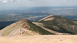 View from about 13,000 feet on Pikes Peak Highway


| Topics | |
|---|---|
| Lists by state |
|
| Lists by insular areas | |
| Lists by associated state | |
| Other areas | |
| Related | |
- Fourteeners of Colorado
- Geography of Colorado
- Mountain ranges of Colorado
- National Historic Landmarks in Colorado
- Pikes Peak
- Rocky Mountains
- Visitor attractions in El Paso County, Colorado
- Geography of El Paso County, Colorado
- Pike National Forest
- National Register of Historic Places in Colorado
- Natural features on the National Register of Historic Places