
Leeds, Alabama: Difference between revisions
→Demographics: Major statistics of income, per capita, persons counts, and other general demographics. |
|||
| Line 78: | Line 78: | ||
|footnote=source:<ref>{{cite web|url=http://www.census.gov/prod/www/abs/decennial/index.html|title=CENSUS OF POPULATION AND HOUSING (1790-2000)|publisher=[[U.S. Census Bureau]]|accessdate=2012-02-20}}</ref> |
|footnote=source:<ref>{{cite web|url=http://www.census.gov/prod/www/abs/decennial/index.html|title=CENSUS OF POPULATION AND HOUSING (1790-2000)|publisher=[[U.S. Census Bureau]]|accessdate=2012-02-20}}</ref> |
||
}} |
}} |
||
As of the [[census]]{{GR|2}} of |
As of the [[census]]{{GR|2}} of 2010, there were 11,773 people, and 4,818 households. The [[population density]] was 514.9 people per square mile. There were 5,221 housing units at an average density of 205.2 per square mile. The racial makeup of the city was 78.7% [[Race (United States Census)|White]], 14.3% [[Race (United States Census)|Black]] or [[Race (United States Census)|African American]], 0.4% [[Race (United States Census)|Native American]], 0.6% [[Race (United States Census)|Asian]], 0.1% [[Race (United States Census)|Pacific Islander]], and 2% from two or more races. 6.6% of the population were [[Race (United States Census)|Hispanic]] or [[Race (United States Census)|Latino]] of any race. |
||
There were 4, |
There were 4,818 households out of which 21.9% had children under the age of 18 living with them, 52% had a female householder with no husband present, and 30.5% were non-families. 14.8% had someone living alone who was 65 years of age or older. The average household size was 2.48. Not much family data was found. |
||
In the city the population was spread out with |
In the city, the population was spread out with 21.9% under the age of 18 and 14.8% who were 65 years of age or older. No gender ratios were found. |
||
The median income for a household in the city was $ |
The median income for a household in the city was $44,149. The [[per capita income]] for the city was $22,716. About 14.6% of the population were below the [[poverty line]]. |
||
==Education== |
==Education== |
||
Revision as of 09:24, 28 May 2013
Leeds, Alabama | |
|---|---|
 Location predominantly in Jefferson County and the state of Alabama | |
| Country | United States |
| State | Alabama |
| Counties | Jefferson, St. Clair, Shelby |
| Area | |
| • Total | 22.4 sq mi (58.3 km2) |
| • Land | 22.3 sq mi (57.9 km2) |
| • Water | 0.1 sq mi (0.4 km2) |
| Elevation | 627 ft (191 m) |
| Population (2010) | |
| • Total | 11,773 |
| • Density | 466.7/sq mi (179.3/km2) |
| Time zone | UTC-6 (Central (CST)) |
| • Summer (DST) | UTC-5 (CDT) |
| ZIP code | 35094 |
| Area code | 205 |
| FIPS code | 01-41968 |
| GNIS feature ID | 0152018 |
| Website | http://www.leedsalabama.gov/ |
Leeds is a tri-county municipality located in Jefferson, St. Clair, and Shelby Counties in the U.S. state of Alabama. It is an eastern suburb of Birmingham. As of the 2010 census, the population of the city is 11,773.
History
Leeds was incorporated on April 27, 1887. Its success was due to: the incorporation of nearby Birmingham and the beginning of iron ore production there; the building of the Georgia Pacific Railway from Birmingham to Atlanta; and the construction of a Portland Cement manufacturing plant in 1906.
The city recently broke away from the Jefferson County school system and initiated its own Leeds City school system. Leeds is poised to make a leap forward in development and population as the eastward population shift continues into Jefferson County and St. Clair County. Leeds has also benefited from the recent addition of the Barber Motorsports Park and the world's largest Bass Pro Shops Outlet that opened in November 2008. In November 2010, The Outlets of Grand River shopping complex opened in proximity to the Motorsports Park and the Bass Pro Shop. These developments are expected to become magnets for visitors and sources of income, as well as significantly increasing the profile of the city.
Geography
Leeds is located at 33°32′44″N 86°33′27″W / 33.54556°N 86.55750°W (33.545592, -86.557388)Template:GR, primarily within Jefferson County.
According to the U.S. Census Bureau, the city has a total area of 22.5 square miles (58 km2), of which, 22.4 square miles (58 km2) of it is land and 0.2 square miles (0.52 km2) of it (0.67%) is water.
Demographics
| Census | Pop. | Note | %± |
|---|---|---|---|
| 1910 | 810 | — | |
| 1920 | 1,600 | 97.5% | |
| 1930 | 2,529 | 58.1% | |
| 1940 | 2,910 | 15.1% | |
| 1950 | 3,306 | 13.6% | |
| 1960 | 6,162 | 86.4% | |
| 1970 | 6,991 | 13.5% | |
| 1980 | 8,638 | 23.6% | |
| 1990 | 9,946 | 15.1% | |
| 2000 | 10,455 | 5.1% | |
| 2010 | 11,773 | 12.6% | |
| source:[1] | |||
As of the censusTemplate:GR of 2010, there were 11,773 people, and 4,818 households. The population density was 514.9 people per square mile. There were 5,221 housing units at an average density of 205.2 per square mile. The racial makeup of the city was 78.7% White, 14.3% Black or African American, 0.4% Native American, 0.6% Asian, 0.1% Pacific Islander, and 2% from two or more races. 6.6% of the population were Hispanic or Latino of any race.
There were 4,818 households out of which 21.9% had children under the age of 18 living with them, 52% had a female householder with no husband present, and 30.5% were non-families. 14.8% had someone living alone who was 65 years of age or older. The average household size was 2.48. Not much family data was found.
In the city, the population was spread out with 21.9% under the age of 18 and 14.8% who were 65 years of age or older. No gender ratios were found.
The median income for a household in the city was $44,149. The per capita income for the city was $22,716. About 14.6% of the population were below the poverty line.
Education
Leeds is served by the Leeds City School District.[2][3]
In 2009, the City of Leeds Board of Education authorized the construction—completed by the Wyatt Construction Company—of two new schools, Leeds Middle School and Leeds High School. They began construction in 2009 and now have completed both schools. The Leeds BOE also authorized the renovations of and additions to Leeds Elementary School, which began in 2008. These renovations were made by the Wyatt Construction Company, they include an expanded office and a new awning around the front of the school.
On December 4, 2008 the Leeds High School Green Wave Football team won the Class 3A AHSAA State Football Championship and finishing the year 15-0, beating the Cordova Blue Devils in the Super Six Tournament at historic Legion Field in Birmingham, Alabama. On February 28, 2009, the Green Wave Basketball team won the 3A AHSAA State Basketball Championship by defeating Madison Academy, 72-64.
On December 6, 2010 the Green Wave Football team won the Class 3A AHSAA State Football Championship and finishing the year 15-0, beating the Hamiton raiders in the Super Six Tournament on Pat Dye Field at Jordan Hare Stadium in Auburn, Alabama.
The Leeds High School Track and Field team has won several state championships.
Famous natives
- Charles Barkley, Basketball Hall of Famer
- Henry E. Erwin, Medal of Honor recipient - World War II
- Kenneth L. Farmer, Jr. MG USA (Ret), Deputy Surgeon General, U.S. Army and Chief of Staff, U.S. Army Medical Command
- Caitlín R. Kiernan, author and paleontologist
- William R. Lawley, Jr., Medal of Honor recipient - World War II
- Mark Martin, cartoonist
- Alford L. McLaughlin, Medal of Honor recipient - Korean War
- Paige Phillips, Miss Alabama 1980; 1st runner-up to Miss America 1981
- Dixie Walker, professional baseball player and coach
- Harry Walker, professional baseball player and manager
- Dennis E. Webb Jr., Nuclear Chemist and Best of Set Awardee
- Ramey Channell, author, poet, illustrator, artist
References
- ^ "CENSUS OF POPULATION AND HOUSING (1790-2000)". U.S. Census Bureau. Retrieved 2012-02-20.
- ^ "Leeds City School District schools, Leeds - AL: charter and public schools. Leeds school district - Leeds AL school district". Greatschools.net. 2010-09-07. Retrieved 2011-02-16.
- ^ "Mobile, Alabama Real-Time News –". Al.com. Retrieved 2011-02-16.
External links
- Official Website of the City of Leeds
- Leeds Herald Community Website
- Outlet Shops of Grand River
- Barber Motorsports Park
33°32′44″N 86°33′27″W / 33.545592°N 86.557388°W
Municipalities and communities of Jefferson County, Alabama, United States | ||
|---|---|---|
| Cities |  | |
| Towns | ||
| CDPs | ||
| Other unincorporated communities | ||
| Former towns | ||
| Footnotes | ‡This populated place also has portions in an adjacent county or counties | |
Municipalities and communities of St. Clair County, Alabama, United States | ||
|---|---|---|
| Cities |  | |
| Towns | ||
| Unincorporated communities | ||
| Former towns | ||
| Footnotes | ‡This populated place also has portions in an adjacent county or counties | |
Municipalities and communities of Shelby County, Alabama, United States | ||
|---|---|---|
| Cities | 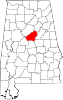 | |
| Towns | ||
| CDPs | ||
| Other unincorporated communities | ||
| Footnotes | ‡This populated place also has portions in an adjacent county or counties | |