<!-- mark request as {{resolved|1=~~~~}} when finished or {{stale|1=~~~~}} when inactive for at least one month -->
<gallery>
Wales location map.svg|Wales location map
</gallery>
;Article(s):
: [[Bettws]]
;Request:
: [[Bettws]] is a [[WP:DAB|disambiguation page]] and I thought it would be helpful to include a map of Wales graphically showing all the "Bettws"s - [http://www.darrinward.com/lat-long/?id=364320 something like this]. Each pin point should probably be labeled with the unambiguous names, or at the very least numbered to correspond with the table that exists at the dab page now. It would be really cool if links to the appropriate wikipedia articles could be mapped to the image too. Unfortunately this may mean a rather large image. Finally (and I know this is asking a lot), if it's possible to verify that these locations are actually referred to as "Bettws" or "Betws" per [[WP:PTM]] that would be a big help for this American. Thanks you! -- [[User:Hoof Hearted|Hoof Hearted]] ([[User talk:Hoof Hearted|talk]]) 19:32, 25 November 2014 (UTC)
;Graphist opinion(s):
*{{tping|Hoof Hearted}} At the moment there appear to be 13 "live" articles for Bettws, plus another two if you want the rugby and football team marked. The template {{tl|Location map many}} currently has a limit of nine locations. I don't know if this number can be increased or whether it's a framework/lua restriction. {{u|Jackmcbarn}} will know the answer to that question. [[User:Philg88|<span style="color:#3a23e2; font-weight:bold; text-shadow:grey 0.1em 0.1em 0.1em;"> Philg88 </span>]]<sup>♦[[User_talk:Philg88|talk]]</sup> 08:19, 28 November 2014 (UTC)
*:Try {{tlx|Location map+}} which can enclose any number of {{tlx|Location map~}}. Essentially, {{tlx|Location map+}} is the base map with no points marked; {{tlx|Location map~}} overlays a point on that. You can see it in action at [[2014–15 Premier League#Teams]] which has 15 red dots; 14 have links, one (London) does not because six teams share one dot. --[[User:Redrose64|<span style="color:#a80000; background:#ffeeee; text-decoration:inherit">Red</span>rose64]] ([[User talk:Redrose64|talk]]) 12:20, 28 November 2014 (UTC)
*:{{ping|Hoof Hearted|Philg88}} Actually, the documentation is wrong for {{tl|Location map many}}. It supports an unlimited number of points now that it uses Lua. Both it and the solution Redrose64 mentioned will work. [[User:Jackmcbarn|Jackmcbarn]] ([[User talk:Jackmcbarn|talk]]) 16:13, 28 November 2014 (UTC)
*::{{ping|Redrose64|Jackmcbarn}} Thanks both. I'm going to plump for {{tl|Location map many}} for now. [[User:Philg88|<span style="color:#3a23e2; font-weight:bold; text-shadow:grey 0.1em 0.1em 0.1em;"> Philg88 </span>]]<sup>♦[[User_talk:Philg88|talk]]</sup> 16:21, 28 November 2014 (UTC)
{{Done}}: Please see [[Bettws]] for the result as it is a populated template rather than a map. [[User:Philg88|<span style="color:#3a23e2; font-weight:bold; text-shadow:grey 0.1em 0.1em 0.1em;"> Philg88 </span>]]<sup>♦[[User_talk:Philg88|talk]]</sup> 18:19, 29 November 2014 (UTC)
:A belated, but sincere thank you! That is perfect! [[User:Hoof Hearted|Hoof Hearted]] ([[User talk:Hoof Hearted|talk]]) 13:28, 1 December 2014 (UTC)
== Request for a Rio de Janeiro city locator map ==
== Request for a Rio de Janeiro city locator map ==
The Graphics Lab is a project to improve the graphical content of the Wikimedia projects. Requests for image improvements can be added to the workshop pages: Illustrations, Photographs and Maps. For questions or suggestions one can use the talk pages: Talk:Graphics Lab, Talk:Illustrations, Talk:Photographs and Talk:Maps. This specific page is the requests page for the Map workshop. Anyone can make a request for a map to be created or improved for a Wikipedia article. The standard format for making a request is shown below, along with general advice, and should be followed.
You are encouraged to share information and request advice from others. Also see possible conventions toolbox, map tutorials and topographic map tutorials.
Advice to requesters
What do we do?
Location maps
Area maps (animals, languages, empires, etc.)
Historical and conflict related maps
Battle maps
Technical maps (archaeology, city closeups, etc.)
Sourced requests: If possible, please try to provide a reliable source to create a map. This includes a map already on Wikipedia with a reliable source or an external link.
Please check: Please check back regularly to see if progress has been made or if any additional questions need to be answered before the request can be completed.
Direct collaboration: Some mapmakers are especially interested by one topic area. If you notice a mapmaker fitting your needs, consider asking on their personal talk page to request maps.
{{Reqmap}}: To request a map, you can also tag the talk page of the article in need of a map with or {{Reqmapin|Australia}} (articles then appear in Category:Wikipedia requested maps)
If a request is done to your satisfaction, please mark it with {{resolved}}.
Advice to Graphists
If you have completed work and not received a reply you may use the {{GL Map reply}} template to inform the requester.
Map makers and other visitors to the Graphics Lab may be interested in the RSS feed of changes to this page. You may find it here.
It would be great if this map could be made into an SVG using the world base map I suggest or some other base map. It would make it easier to zoom in on smaller countries. -- grenグレン15:05, 1 April 2014 (UTC)[reply]
The current map (File:World.distribution.amphisbaenia.1.png) is inaccurate, showing, among other things that amphisbaenas occur in Madagascar, in a different area of the Arabian Peninsula from their actual range, and missing their range in Asia Minor. The second page of this article contains an accurate map of Amphisbaenia distribution and I'd like to request that a new map be made for this article based on it. Note that the article has different colors for each Family within the group, and that the range of Amphisbaenia is the aggregate of those ranges. It might also be worthwhile to make a distribution map for each family to be included in the respective articles on those taxa. Cheers! Peter G Werner (talk) 03:01, 7 April 2014 (UTC)[reply]
Need a plain, black & white PNG version of this map
Article(s): Various
Request:
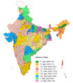
User Soman asked in the Illustration workshop for help on an Indian election map. Because I run my os on a 486, my computer cannot handle images of that size. Can someone give him a hand? Preferably by making a SVG-map of the data provided by him. Or if he doesn't want that, a png-file (emptied of the results of 2009) of the SVG-file already posted here. Wereldburger758 (talk) 07:46, 15 April 2014 (UTC)[reply]
It would be great to have a map comparing the heights of the Tibetan Plateau and the Antarctic, to scale (obviously the vertical scale will have to be much larger than the horizontal scale, but the same scales for both locations). The height of Antarctica is really important to the regional circulation and other features, and it would be great to have a vivid visualization of how tall it is. A N-S transect for Himalaya/Tibetan Plateau, and a 90W-90E one for Antarctica, would work well.
The individual cross-sections, seperately, would make useful and informative images in their own rights, and encourage people to modify them to present geological and biozone information.
Showing the under-ice ground surface is nice, but not essential. See the metadata of the image on the right for a data source.
Request:
I created about 67 maps of each European Parliament constituency (see Category:European_Parliament_constituencies), but after uploading them I realized there are 2 mistakes: Liechtenstein was mistakenly added, and French Southern/Antarctic Territory is not part of the electoral process. Both areas should be grey (Like the good example above). I already corrected all of them once when I changed the Irish constituencies, and I don't have the time to do all of 'em again. Thanks - ArnoldPlaton (talk) 21:09, 21 May 2014 (UTC)[reply]
I downloaded a map and re-hashed it and then re-uploaded it but apparently, this is not a free licence. I was redirected here. Can anyone help? — Preceding unsigned comment added by Darrenjolley (talk • contribs) 11:26, 28 May 2014 (UTC)[reply]
(I have shrunk the image here to a more modest size.)
This image was uploaded to Wikimedia commons by 'CMLW22', who claimed it as "own work" and released it with a Creative Commons Attribution-ShareAlike 3.0 License. Why do you think think it is not a free licence? Anyway, the Commons Help Desk might be a better place to ask. Maproom (talk) 21:48, 30 May 2014 (UTC)[reply]
Need improvement for a map in my sandbox before article creation
Movement of Abu Muslim's Abbasid loyalists against the Umayyad Empire
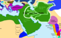
Currently, the Abbasid Revolution is just a redirect to the Umayyad Caliphate. I am working hard on turning the subsection in that article into a full fledged article in my sandbox. The problem is that the image looks a bit amateurish. Also, Umayyad is commonly spelled with a "U," not an "O." -- MezzoMezzo (talk) 11:36, 3 June 2014 (UTC)[reply]
Note that we do not necesarily need to use the first map as a template, you can find another generic map of asia (Mongolia, China, and Russia), with the proper subdivisions, and start it over again.
. -- Rajmaan (talk) 21:09, 10 June 2014 (UTC)[reply]
The map linked above is out of date by a bit. A more modern, updated map is on the Justice Department's website. Both maps are PD-USGov, but both are of poor quality. I'm hoping one of you skilled volunteers can make a US map with the DEA divisions properly included from the Justice Department source. Thanks in advance for your consideration. TLSuda (talk) 21:04, 11 June 2014 (UTC)[reply]
I've attempted this myself, and the above image is my results. Not very good, so if someone wanted to clean it up/make it better, please do! TLSuda (talk) 19:50, 17 June 2014 (UTC)[reply]
Suggestion: Before overwriting the original, please consider creating a new file so that the original is still available if the situation changes. cmɢʟee⎆τaʟκ21:38, 11 September 2014 (UTC)[reply]
I'd particularly love to see a map of "United States Annual Rainbow Gatherings". The article lists the national forest (except for the first year - national park) and state of the gathering. A map would be a valuable addition. As would 4 - one map for each of the 4 sections. --76.216.6.136 (talk) 06:40, 27 June 2014 (UTC)[reply]
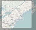
I'd be interested in a similar map that also includes Westchester County, Rockland County, and the rest of Long Island, if that's not too difficult. The amount of detail that is shown on the existing NYC location map (roads, mainly) is not necessarily needed. And now that I think of it, perhaps the New Jersey and Connecticut areas of the tri-state area could be included in the 'lit' portion of the map, if the mapmaker sees fit. Thanks —Akrabbimtalk20:00, 30 June 2014 (UTC)[reply]
Could you make stripes on the attached map as stripes here?: Autonomy territories in Guizhou.png But strips must be equal width and flat. Stripes for autonomous counties must be thinner than for autonomous prefectures. In the boundaries of two APs or ACs with the same peoples, colours have been changed for the border stripes were visible -- Kaiyr (talk) 09:37, 2 July 2014 (UTC)[reply]
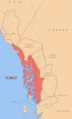
Currently there is only a somewhat atrocious map for the PGO. I quite like this map of the Oregon Country https://commons.wikimedia.org/wiki/File:Oregoncountry2.png but it needs a little work. I ideally would like something to reflect both the political divisions of the PGO along with some additional Euro-American settlements through out the Oregon Country. Some additional pioneer towns should be added, like Champoeg and Portland. Astoria should be renamed to Fort George, despite not being actively used by the Hudson's Bay Company at this time. Additionally, could Fort Boise be added? The missions of Tshimakain, Waiilatpu, Lapwai and Wascopam would be excellent as well. This gives a rough idea to the location of the interior missions. http://www.nps.gov/history/history/online_books/brochures/1947/whmi/images/fig3.jpg
On second look, Hong Kong is already in green, but the dot is so small and thus it is extremely hard to see given the color contrast (Gibraltar is easier to see given it is in red).
Can someone upload an SVG file of EU flag map of Ukraine without Crimea titling it " Ukraine EU (without Crimea)". This map should exist just like there is a map of Serbia with and without Kosovo. -- KronosLine (talk) 07:09, 10 August 2014 (UTC)[reply]
I would like some regional maps. I have added maps of Final Four locations to pages such as NCAA_Women's_Division_I_Basketball_Championship I would like to extend to cover not just Final Four, but all venues. However, it will be too crowded on a single US maps, so I thought I would use three maps, one roughly west of Mississippi, one east of Mississippi excluding roughly New England, and one of New England plus NY, PA, NJ, and DE.
I can handle the coloring of a map in Inkscape, but I do not know how to create the map with the state and country outlines. I can handle the creation of the location map module (I haven't dealt with conic projection, which I think I can ignore on the Northeast map, I will have to figure it out or get some handholding on the other two.
Following are the geographical boundaries of the three desired maps:
West
   50
-126 -89
   25
South and Midwest
   48
-93   -75
   24
Northeast
   48
-81   -66
   38
I also did a screenshot showing what it looks like in OSM, although I am looking for a map that looks more like File:Usa edcp location map.svg
Screenshot of open Source OSM for Northeast region
Screenshot of open Source OSM for South and Midwest region
Hello, I need a couple location maps spanning multiple countries; precisely one of them should be representing France, the United Kingdom and Ireland, and the other both Australia and New Zealand. Their purpose is to indicate the cities that hosted the Rugby World Cups 1987, 1991, 1999 and 2007 which took place in more than one country. Thanks. -- SERGIOaka the Black Cat09:36, 25 August 2014 (UTC)[reply]
District boundaries on Bangladesh location map
Map 1: Current location map, with first-level administrative (division) boundaries
Map 2: Example location map (Albania), with two levels of administrative boundaries
As I've been working on extensively expanding the Raven Tales article which is about they cultural stories of Indians in the north west, it's become apparent that the geography of each tribe and the relation of them to each other is significant to the stories. Reading the stories there is significant detail which describes the geography. I think it would be very interesting to compose a map which displays each of the tribes that have stories of Raven... to see the geographic comparison. Going even further it would be awesome to attempt to plot the journeys of Raven through all of the stories but this may be a very intensive endeavor to take on.
I've added extensive references to the Raven Tales article where you can get access to the original stories if you'd like to start taking a look. Thanks. I found this image [3] which should help as well. -- David Condrey (talk) 20:08, 3 September 2014 (UTC)[reply]
Graphist opinion(s):
County Tipperary and Waterford City
Article(s): Every article these maps are already on.
In addition: afaik, Limerick city and the respective county merged. These (hard to spot) borders were also removed. --TUBS (talk) 17:24, 9 October 2014 (UTC)[reply]
Europe map extrapolated to full Ordnance Survey National Grid
Would any editor here be able to generate either a bitmap or vector map of Europe extrapolated to the full A-Z Ordnance Survey National Grid so that most of the top-left figure in File:Ordnance Survey National Grid.svg needn't be blank, please? If I understood correctly, the projection is a Transverse Mercator centred on 48°N 2°W. -- cmɢʟee⎆τaʟκ21:35, 11 September 2014 (UTC)[reply]
The borders on the rest of the map don't look draw-y because they are precise. They can be precise because they represent something real and well-defined. The borders of the territories of the proposed "Greater Mongolia" were never defined, and it would feel dishonest to draw them as precise. How would it be if someone made them greyer, or invisible, just leaving the pink patches? Unfortunately the pink patches don't quite border Mongolia, so there would be an annoying and incorrect gap. Maproom (talk) 21:48, 23 September 2014 (UTC)[reply]
That's specious-Altai, Tuva, Buryatia and Inner Mongolia, all already labeled on the map, have well-defined borders, and do border Mongolia without any gap. It is a disservice to Wikipedia to have a map up that looks like it was sketched out in MSPaint of an afternoon. The options are improve the map or seek to have it deleted, not another halfway stopgap map that doesn't address the earlier issue.--Kintetsubuffalo (talk) 11:36, 24 September 2014 (UTC)[reply]
A map based on that printed on page 114 of this IUCN pdf file here. If you find some of the names hard to make out, check them out on the wild boar article. NOTE: I couldn't find an image template including Africa along with Eurasia. -- Mariomassone (talk) 20:17, 1 October 2014 (UTC)[reply]
I obtained CC licensed shapefiles for Treaty of Waitangi claims from Te Puni Kōkiri and put them up at https://github.com/stuartyeates/Te-Kahui-Mangai I anticipate that generating useful maps from layers in shapefile these should be relative straightforward for someone with the GIS right software and experience. I'm expecting 20~2000 layers in the shapefile with many / most not having any features. Please out the maps on commons, since these are likely to be useful in the Maori language wikipedia too. -- Stuartyeates (talk) 22:21, 7 October 2014 (UTC)[reply]
The outdated (for now) map of the Montreal subway system
Hello. The last update of the map was in 2013. Since then, Square-Victoria was renamed to Square-Victoria–OACI. It would also be good for the code to be cleaned up. Thanks, ~~Ebe123~~ → report01:54, 18 October 2014 (UTC)[reply]
Article(s): each one's used in its province's article
Request:
These are maps of South Korea's five provinces under North Korean rule. All five of them look like they were scanned from a book, and they're all hard to read. Could you please make simple locator maps for them, drawn like File:Ghana-Northern.png or File:Lori.svg? The original upload of each image consists of such a map, but the book-scan upload was accompanied by an upload summary of "accurate borders", so apparently the original uploads aren't trustworthy. 65.210.65.16 (talk) 13:53, 23 October 2014 (UTC)[reply]
Request:
Hi, I am hoping that someone would be able to create a map to be used in the above article to illustrate the French defensive positions and certain key towns and villages associated with the invasion. At present there is no map to support the article, and the creation of such would vastly benefit the article and help the reader pinpoint the various locations mentioned in the text.
I only have access to an e-copy of the below source and the low-res map contained on 174. I have uploaded several copies, including a zoomed in version (if it helps any), and one clearly marking the various French positions as highlighted in the accompanying key. If possible, could the map show the elevations (not clearly shown on the map), the 27 French defensive areas (per the key and highlighted), as well as the following key towns and villages: Briançon, Montgenèvre (not shown on the map, but located just to the east of Briançon), and Menton. If possible, could the Italian and French divisions also be included to show the general disposition of both sides?
I have been unable to find any additional maps showing the French defensive positions, but would be willing to provide any other assistance as needed. Regards -- EnigmaMcmxc (talk) 23:32, 30 October 2014 (UTC)[reply]
Source: Kaufmann, J.E; Kaufmann, H.W (2007). Fortress France: The Maginot Line and French Defenses in World War II. Stackpole Military History Series. Stackpole Books. ISBN978-0-811-73395-3. {{cite book}}: Invalid |ref=harv (help); Unknown parameter |lastauthoramp= ignored (|name-list-style= suggested) (help) (Map is attributed to Joseph Kaufmann)
Caption that accompanies the map, on page 175: "Figure 6-6. Alpine front and Maginot ouvrages. This map shows the location of French and Italian units in the 1940 and also identifies all French ouvrages of the Little Maginot of the Alps."
The article needs a location map of Spain and France together. Currently the article has two separate maps, but it would look much better if there was just one map. If it could have the Basque Country (greater region) shaded darker, or a different color such as Blue that would be really useful. Adam Cli (talk) 12:20, 6 November 2014 (UTC)[reply]
I was hoping someone could modify this French map for Wikiprojects related to the Pacific Northwest. The issue with the map is it isn't terribly accurate for the area disputed between the UK and the US prior the 1846 Oregon Treaty. The Americans consistently for decades claimed the portion of Vancouver Island south of the 49th parallel. A different coloured line following the area at times claimed by both nations, modern Western Washington state and most of British Columbia would beneficial. The second map at least gives an idea for the course of the continental divide and the more extensive American claim of 54'40. The French language itself isn't an issue for me, given it is SVG. Thanks! -- Voltaire's Vaquero (talk) 08:29, 8 November 2014 (UTC)[reply]
Graphist opinion(s):
Wolf range update
Range map to be modified (the new African range should be in green).
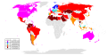
I don't even understand the map. It should depict Shares of World GDP, but in what way? Please clean this up as to make it understandable at first sight. I have no idea how at the moment, but (sorry for the harsh words) at the moment it seems that any other way would make it clearer. Thank you.... -- Lommes (talk) 14:47, 14 November 2014 (UTC)[reply]
According to the article, the IMO's newest member state is Zambia, but Zambia's still marked as a nonmember on the map. Please change its color to reflect its membership. PS, the article says that Niger isn't a member, but it's marked as a member on the map; switching its colors would also help. For bonus points, add South Sudan (nonmember), although that would probably take a good deal of extra work. -- Nyttend (talk) 14:03, 16 November 2014 (UTC)[reply]
Graphist opinion(s):
I fixed it, however after uploading the file, I see no difference so it may have been an issue with the code or I'm just not looking properly. ///EuroCarGT20:23, 16 November 2014 (UTC)[reply]
The location map image is a OpenStreetMap image, if possible you can try going on OSM and selecting the desired area, export it as a PNG and upload it from there. ///EuroCarGT00:50, 5 December 2014 (UTC)[reply]
You need to use the third party Maperitive tool to export the SVG after getting the raw data from the Overpass API. It's a bit of an arcane process so if you tell me the decimal coordinates you want covered by the map (top left, bottom right) I'll sort it out for you. Philg88 ♦talk08:43, 9 December 2014 (UTC)[reply]
@EnigmaMcmxc: I'm not sure what you are looking for but now there is a draft on one of the maps for you to look at. In some areas of the map there is a lot of information so it gets crowded. Have a look and tell me what you want, what to change and so on, you are the one with the knowledge of this subject and you know what you are looking for. Draft to look at and give me feedback, thanks. --Goran tek-en (talk) 14:51, 16 December 2014 (UTC)[reply]
Thanks very much. Excellent work so far. Can the location of the Alpine unit be moved? It needing to go to the bottom left of the map to match the original. Would it also be possible to change the background colour, for me it just doesn't work (although I would not have any suggestions other than perhaps a green?). In addition, "arc" at the top of map is the Arc River (L'Arc on Google Maps), which runs across the top of the map. Could this be amended to state such per the other rivers on the map? I was unable, for the moment, to find what "Kiv" stands for or what it is suppose to represent. As mentioned, the Arc - per Google - runs across the top of the map. For now, could Kiv be removed?
While there is a lot of information on the map, it now being in colour makes it much easier to read (not to mention its free, whereas the original I do not think would hold up if scrutinized). The shaded area on the map, next to the lake poses an issue for me. I do not know what it is suppose to represent on the original map. The staging area for the 11th Division? For ease of reading, this may need to go too.EnigmaMcmxc (talk) 23:45, 16 December 2014 (UTC)[reply]
The map is based on an article that was translated from Russian. Some French and Italian placenames got garbled. "Kiv" is just a typo for "Riv", as in river. Note that "Cemschia" should be "Val Cenischia". The "Ribbon" is actually the Ribon; "Sollierés" should be Sollières; "Le Plenet" should be Le Planay; "Ft Balm" should be Ft de la Balme; "Giazette" is the Col des Lacs Giaset; and Étache has an acute accent. The solid and dashed orange lines (in your rendition) are roads. The line you show as a black-and-white dashed line is the border.
@EnigmaMcmxc: We who create maps here try to follow map guidlines so that all of the maps looks more or less the same. In that way it's much easier for the viewers to understand and take in the information, for this reason we use a template Maps_template and it has three different colors for land so with the new information from Srnec I have made some changes.
I also think that the area next to the lake is the area of the 11th Inf Div and with the new information I kept it. If it still should be removed just tell me.
Question: I have added some information in the legend but you should check so that the dashed orange lines really is rods in tunnels or tell me what it is? Now when I started the second map I think the dashed orange lines maybe just minor roads? They are too long and many to be tunnels I think. Get back to me on that, thanks.
@Srnec: You wrote "The "Ribbon" is actually the Ribon" but I can't find that word. Question: Where is it?
I agree that the dashed lines are probably not tunnels. I suspect they are unpaved or seasonal roads. The "Ribbon" river is the torrent du Ribon, a mountain stream. Also, since col is just French for "pass", Col des Lacs Giaset Pass is redundant. "Lacs Giaset pass" will do.
On the other map... Solage should be Seloge, Seign should be Seigne, Les Chapieu should be Les Chapieux, what looks like Setz is Séez, Rocher Pass is the Rocher Blanc Pass to be precise, and Moûtiers has a circumflex. The "Trieste Division" and the "Motorized Division" are the same division: the 101st Motorised Division Trieste. The big arrow pointing at Albertville represents the goal of the offensive and not a troop movement. The map does not have a compass rose, but I think it is oriented with north at top. Hope this helps. Srnec (talk) 20:40, 17 December 2014 (UTC)[reply]
@EnigmaMcmxc:@Srnec: Thanks for the feedback and information it helps me a lot. Now there are two new drafts to look at and give me feedback on.
The colouring of the glaciers seems a little off. Isn't it supposed to be the same as the country/background?
In the Bourg St Maurice map, the small blue arrow pointing southeast just below the small permanent fort is, I believe, supposed to represent the action of a regiment passing through the Col de la Traversette to attack the fort there from the rear. (Maybe the permanent fort indicated on the original map is supposed to be that fort, in which case it or the arrow is wrongly placed. So I'll assume it is not.) The fort they were trying to outflank was the Redoute Ruinée (ruined before 1940 and still ruined now) and if you look it up on Google Maps you'll see how it and the Col de la Traversette relate, and how they are approximately in the location to which that little arrow points. It has approximately a north–south orientation.
The glaciers have a weak tone of white in them, it's the same on both maps. It's more viible on the "Italy" country color. If you don't want it on either map tell me, but I think it's more understandable/visible like that.
I did look up Redoute Ruinée on google maps but Col de la Traversette is more than 5 hours drive from there what I can see so is that really the same?
If you have a link which shows this better or if you make a sketch or something I will edit but right now I don't know what to do?
I did an edit but I'm not sure it's correct. Look at Italian_offensive_Bourg_Saint-Maurice and give me feedback. Maybe you have to reload to get the new one.
How is the "Mont_Cenis" map, is it correct now? --Goran tek-en (talk) 13:48, 20 December 2014 (UTC)[reply]
I should have explained better. There is another Col de la Traversette that is far away. That's why I suggested googling Redoute Ruinée. The Traversette pass that we're looking for is at 45.657551, 6.877360. You'll see it pretty clearly—and its relationship to the fort and the Little St Bernard—in Google Earth. I'd show it as a north–south pass to which that little arrow is pointing. The Mont Cenis map looks fine to me. Srnec (talk) 18:24, 20 December 2014 (UTC)[reply]
Now this map is uploaded to commons Italian offensive Mont Cenis-1940 but you guys should check the Description, categories and so on.
@EnigmaMcmxc:@Srnec: Thanks for your help both of you! You guys should check the files for description, categories and so on.
Excellent work. Thank you for your time and effort :) I don't suppose you would be willing to give the other map request - further up the page and for the same article - a look over?EnigmaMcmxc (talk) 12:04, 21 December 2014 (UTC)[reply]
@EuroCarGT: Assuming you choose to make an equirectangular projection (which is the easiest way to go about it), you just need to know the latitudes of the top and bottom of the image, and the longitudes of the left and right of it. Jackmcbarn (talk) 03:42, 10 December 2014 (UTC)[reply]
I got the OSM XML of Chicago with the coordinates as stated above, added into QGIS, rendered it as a SVG and it does not seem good... I'll keep trying. ///EuroCarGT05:26, 10 December 2014 (UTC)[reply]
I am requesting a new map detailing the location of the Amabassador Bridge. The current map is unsatisfactory because it is largely based on a map of Michigan. I request that a new map be made that is more 'zoomed' in so that it includes more of Ontario and better reflects the nature of the bridge as bordering two countries.
I would like to request a customised location map based on File:Brazil_location_map.svg. The purpose is to show the location of football teams in the South East region. Per 2015 Campeonato Brasileiro Série A, the map is unable to display teams in the South East (São Paulo and Rio de Janeiro teams overlap). I would like to request an inset be included, with the top left of the inset being -19.097861, -48.395786 and the bottom left being -24.020803, -39.365025. Hack (talk) 07:15, 16 December 2014 (UTC)[reply]
The map uses outdated data from 2005, the linked page already uses 2012 data. please update with the new data. also recreating the map in svg would probably save some time whenever this is done next… Thank you! -- 179.63.245.34 (talk) 20:42, 19 December 2014 (UTC)[reply]
Description of third image (if needed; don't request too many at once, though)
Article(s)
[[<Depth Map for Mediterranean>]]
Request
I noticed that you do not have a depth map for the Mediterranean sea. The only one I found was at http://www.divinglore.com/Genesis/Mediterranean%20Depth%20Chart.html. I think Wikipedia should have one. I am not tech savy so hope this gets to you. You could have made it easier for less accomplished users. Tom T. Moore
This is a featured list and we are in the process of updating for the results of the 2014 elections. Unfortunately, in the meantime the state has undergone redistricting and the current map is based on the districts from the 2000 redistricting rather than the current districts. So we need someone willing to redo the map based on the new districts. Maryland's maps of he new districts for the new lines can be found here: http://planning.maryland.gov/redistricting/. Coloring of the districts can be based on the updated list already added to the article. We will also need an updated version of the Maryland Senate map, although we have not yet updated the list at List of current members of the Maryland Senate. -- Geraldk (talk) 16:25, 24 December 2014 (UTC)[reply]
I'm on the verge of editing multiple articles related to the Toxostoma genus, and I would like to have maps made for each of the following species, if possible.
Done@LeftAire: All three maps created, uploaded, added to articles. Maps are categorized at Commons under the binomials. Let me know if problems, either ping here or leave message on my talk page. Good luck with the articles! Gaff (talk) 19:20, 5 January 2015 (UTC)[reply]
Each A-League season's pages contain a map with icons showing the geographical locations of the teams in the A-League. I have no issues about aligning these myself, the only problem I'm having is that they appear quite cramped around the Sydney region where there are currently four teams (which could extend to as many as six soon). I think this would look a lot better with an inset on the map magnifying Brisbane, Sydney, Melbourne and Canberra; or even just around Sydney and Canberra, with the inset perhaps placed in the blank top right area of the map above New Zealand.
Okay: I have a map, which is available with a CC 2.0 free license from OpenStreetMap. I mapped out the neighborhood and the link is here. There are features that you can tweak, to change the background map, to include less or more detail. It can also be scaled. The download feature is stuck right now, due to too high a load on the server. @AgnosticPreachersKid:: Is this enough information to get you going? More experienced cartographers might do a a better job with this. There are similar maps of the DC neighborhoods here on Commons. They have templates with appropriate licensing. If you are stuck, I can try again later to download the map, but if you can do it yourself, it might be easier for you to customize. Hope that this is somehow helpful. Gaff (talk) 05:29, 6 January 2015 (UTC)[reply]
How is this? It can probably be cropped and somebody smarter than me might be able to get rid of the Safeway shopping cart. Gaff (talk) 07:12, 6 January 2015 (UTC)[reply]


 Existing rail gauge map
 Outdated SVG version

 Map of ongoing armed conflicts. Change is requested for Egypt, China, N. Korea, S. Korea and Paraguay.
 Need a plain, black & white PNG version of this map


 Indonesia Ethnic Groups Map English
 Indonesian Province
 EP constituencies (already fixed)
 Austria (needs fixing)
 Belgium - German-speaking (needs fixing)
 Belgium - French-speaking (needs fixing)
 Belgium - Dutch-speaking (needs fixing)
 Bulgaria (needs fixing)


 Philippine EEZ

 Movement of Abu Muslim's Abbasid loyalists against the Umayyad Empire
 Map representing Pan-Mongolian claims
 Yellow is the Zungharian Basin

 Map of DEA Field Divisions (outdated)
 My attempt


 Riga city center
 Riga metropolitan

 Existing NYC location map
 Autonomy territories in Townsips map Guizhou
 PNG image, uploaded in Wikipedia
 The current map of the PGO

 Ukraine EU flag with Crimea
 Serbia EU flag with Kosovo
 Serbia EU flag without Kosovo
.svg)
.svg)
 Screenshot of open Source OSM for Northeast region
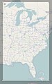 Screenshot of open Source OSM for South and Midwest region
 Screenshot of open Source OSM for West region


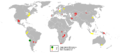
 Location map of Europe
 Location map of Oceania

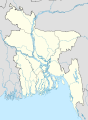 Map 1: Current location map, with first-level administrative (division) boundaries
 Map 2: Example location map (Albania), with two levels of administrative boundaries


 Tlingit tribe geography
 Regional map
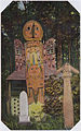 The Raven sits on a frog after having rescued children from a flood.
_Ethnographische_Karte,_das_Gebiet_der_TLINKIT.jpg)


 Template
 The outdated (for now) map of the Montreal subway system
.jpg)
.jpg)
.jpg)
.jpg)
.jpg)
 How about this as a starter?
 Request taken by Goran tek-en (talk) 17:20, 22 December 2014 (UTC). But I will not be able to start the work for about 12 days. --Goran tek-en (talk) 17:20, 22 December 2014 (UTC)


 Range map to be modified (the new African range should be in green).
 Template.
![World share of GDP (PPP) (World Bank, 2011). Source: [1]](//upload.wikimedia.org/wikipedia/commons/thumb/7/7b/%C2%B4World_Bank%2C_icp_2011_gdp_ppp_world_share.png/120px-%C2%B4World_Bank%2C_icp_2011_gdp_ppp_world_share.png) World share of GDP (PPP) (World Bank, 2011). Source: [1]
World share of GDP (PPP) (World Bank, 2011). Source: [1]![World share of GDP (PPP) (World Bank, 2011). Source: [1]](/wiki/File:%C2%B4World_Bank,_icp_2011_gdp_ppp_world_share.png)
 Needs updating to 2014 version
 Created in January 2014, the new report was published in June 2014

 Map of International Maritime Organization member states
 mosaic-y automated borders
 actual borders


 Done There you go. Philg88 ♦talk 10:37, 10 December 2014 (UTC)


 Question: I have added some information in the legend but you should check so that the dashed orange lines really is rods in tunnels or tell me what it is? Now when I started the second map I think the dashed orange lines maybe just minor roads? They are too long and many to be tunnels I think. Get back to me on that, thanks.
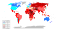 Update needed
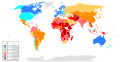 Update needed

 Map of Chicago by community area

 Map of Guernsey

 The current image (data of 2005)
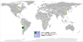 Replacement image (data of 2012)
.PNG)
.svg)
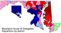 Maryland House of Delegates Map
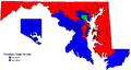 Maryland Senate Map


 This is the original map, utilised in the articles
![[2]](https://en.wikipedia.org/wiki/File:Worldmap_location_NED_50m_20000-10027.png)
![[3]](http://www.bced.gov.bc.ca/abed/images/map2.jpg)
.svg)

