Rank[ i]
Mountain name(s)
Height[ ii]
Prominence[ iii]
Range
Coordinates[ iv]
Parent mountain [ v] Ascents before[ vi]
Country
Photo
1st
successful
m
ft
m
ft
y
n
1
8,849
29,032[ a]
8,849
29,032
Mahalangur Himalaya
27°59′17″N 86°55′30″E / 27.9881°N 86.925°E / 27.9881; 86.925 (1. Mount Everest / Sagarmatha / Chomolungma / Zhumulangma (8848 m) ) —
1953
145
121
2
K2
8,611
28,251
4,020
13,190
Baltoro Karakoram
35°52′53″N 76°30′48″E / 35.88139°N 76.51333°E / 35.88139; 76.51333 (2. K2 / Qogir / Godwin Austen (8611 m) ) Mount Everest
1954
45
44
3
Kangchenjunga
8,586
28,169
3,922
12,867
Kangchenjunga Himalaya
27°42′12″N 88°08′51″E / 27.70333°N 88.14750°E / 27.70333; 88.14750 (3. Kangchenjunga (8586 m) ) Mount Everest
1955
38
24
4
Lhotse
8,516
27,940
610
2,000
Mahalangur Himalaya
27°57′42″N 86°55′59″E / 27.96167°N 86.93306°E / 27.96167; 86.93306 (4. Lhotse (8516 m) ) Mount Everest
1956
26
26
5
Makalu
8,485
27,838
2,378
7,802
Mahalangur Himalaya
27°53′23″N 87°05′20″E / 27.88972°N 87.08889°E / 27.88972; 87.08889 (5. Makalu (8485 m) ) Mount Everest
1955
45
—
6
Cho Oyu
8,188
26,864[ c]
2,340
7,680
Mahalangur Himalaya
28°05′39″N 86°39′39″E / 28.09417°N 86.66083°E / 28.09417; 86.66083 (6. Cho Oyu (8188 m) ) Mount Everest
1954
79
28
7
Dhaulagiri I
8,167
26,795
3,357
11,014
Dhaulagiri Himalaya
28°41′48″N 83°29′35″E / 28.69667°N 83.49306°E / 28.69667; 83.49306 (7. Dhaulagiri I (8167 m) ) K2
1960
51
39
Nepal
8
Manaslu
8,163
26,781
3,092
10,144
Manaslu Himalaya
28°33′00″N 84°33′35″E / 28.55000°N 84.55972°E / 28.55000; 84.55972 (8. Manaslu (8163 m) ) Cho Oyu
1956
49
45
Nepal
9
Nanga Parbat
8,126
26,660
4,608
15,118
Nanga Parbat Himalaya
35°14′14″N 74°35′21″E / 35.23722°N 74.58917°E / 35.23722; 74.58917 (9. Nanga Parbat (8126 m) ) Dhaulagiri
1953
52
67
Pakistan
10
Annapurna I
8,091
26,545
2,984
9,790
Annapurna Himalaya
28°35′44″N 83°49′13″E / 28.59556°N 83.82028°E / 28.59556; 83.82028 (10. Annapurna I (8091 m) ) Cho Oyu
1950
97
88
Nepal
11
8,080
26,510
2,155
7,070
Baltoro Karakoram
35°43′28″N 76°41′47″E / 35.72444°N 76.69639°E / 35.72444; 76.69639 (11. Gasherbrum I / Hidden Peak / K5 (8080 m) ) K2
1958
31
16
12
Broad Peak
8,051
26,414
1,701
5,581
Baltoro Karakoram
35°48′38″N 76°34′06″E / 35.81056°N 76.56833°E / 35.81056; 76.56833 (12. Broad Peak / K3 (8051 m) ) Gasherbrum I
1957
39
19
Pakistan , China
13
8,035
26,362
1,524
5,000
Baltoro Karakoram
35°45′28″N 76°39′12″E / 35.75778°N 76.65333°E / 35.75778; 76.65333 (13. Gasherbrum II / K4 (8035 m) ) Gasherbrum I
1956
54
12
Pakistan , China
14
8,027
26,335
2,897
9,505
Jugal Himalaya
28°21′12″N 85°46′43″E / 28.35333°N 85.77861°E / 28.35333; 85.77861 (14. Shishapangma (8027 m) ) Cho Oyu
1964
43
19
China
15
Gyachung Kang
7,952
26,089
672
2,205
Mahalangur Himalaya
28°05′53″N 86°44′42″E / 28.09806°N 86.74500°E / 28.09806; 86.74500 (15. Gyachung Kang (7952 m) ) Cho Oyu
1964
5
3
S
7,946
26,070
355
1,165
Baltoro Karakoram
35°45′33″N 76°38′30″E / 35.75917°N 76.64167°E / 35.75917; 76.64167 (Gasherbrum III (7946 m) ) Gasherbrum II
1975
2
2
Pakistan , China
16
Annapurna II
7,937
26,040
2,437
7,995
Annapurna Himalaya
28°32′05″N 84°07′19″E / 28.53472°N 84.12194°E / 28.53472; 84.12194 (16. Annapurna II (7937 m) ) Annapurna I
1960
6
19
Nepal
17
7,932
26,024
712
2,336
Baltoro Karakoram
35°45′38″N 76°36′58″E / 35.76056°N 76.61611°E / 35.76056; 76.61611 (17. Gasherbrum IV (7932 m) ) Gasherbrum III
1958
4
11
Pakistan
18
Himalchuli
7,893
25,896
1,633
5,358
Manaslu Himalaya
28°26′12″N 84°38′23″E / 28.43667°N 84.63972°E / 28.43667; 84.63972 (18. Himalchuli (7893 m) ) Manaslu
1960
6
12
Nepal
19
Distaghil Sar
7,884
25,866
2,525
8,284
Hispar Karakoram
36°19′33″N 75°11′16″E / 36.32583°N 75.18778°E / 36.32583; 75.18778 (19. Distaghil Sar (7884 m) ) K2
1960
3
5
Pakistan
20
Ngadi Chuli
7,871
25,823
1,011
3,317
Manaslu Himalaya
28°30′12″N 84°34′00″E / 28.50333°N 84.56667°E / 28.50333; 84.56667 (20. Ngadi Chuli (7871 m) ) Manaslu
1979
1
6
Nepal
S
Nuptse
7,864
25,801
305
1,001
Mahalangur Himalaya
27°58′03″N 86°53′13″E / 27.96750°N 86.88694°E / 27.96750; 86.88694 (Nuptse (7864 m) ) Lhotse
1961
5
12
Nepal
21
Khunyang Chhish
7,823
25,666
1,765
5,791
Hispar Karakoram
36°12′19″N 75°12′28″E / 36.20528°N 75.20778°E / 36.20528; 75.20778 (21. Khunyang Chhish (7823 m) ) Distaghil Sar
1971
2
6
Pakistan
22
7,821
25,659
2,457
8,061
Masherbrum Karakoram
35°38′28″N 76°18′21″E / 35.64111°N 76.30583°E / 35.64111; 76.30583 (22. Masherbrum / K1 (7821 m) ) Gasherbrum I
1960
4
9
Pakistan
23
Nanda Devi
7,816
25,643
3,139
10,299
Garhwal Himalaya
30°22′33″N 79°58′15″E / 30.37583°N 79.97083°E / 30.37583; 79.97083 (23. Nanda Devi (7816 m) ) Dhaulagiri
1936
14
12
India
24
Chomo Lonzo
7,804
25,604
590
1,940
Mahalangur Himalaya
27°55′50″N 87°06′28″E / 27.93056°N 87.10778°E / 27.93056; 87.10778 (24. Chomo Lonzo (7804 m) ) Makalu
1954
3
1
China
25
Batura Sar
7,795
25,574
3,118
10,230
Batura Karakoram
36°30′37″N 74°31′21″E / 36.51028°N 74.52250°E / 36.51028; 74.52250 (25. Batura Sar (7795 m) ) Distaghil Sar
1976
4
6
Pakistan
26
Rakaposhi
7,788
25,551
2,818
9,245
Rakaposhi-Haramosh Karakoram
36°08′33″N 74°29′22″E / 36.14250°N 74.48944°E / 36.14250; 74.48944 (26. Rakaposhi (7788 m) ) Khunyang Chhish
1958
8
13
Pakistan
27
Namcha Barwa
7,782
25,531
4,106
13,471
Assam Himalaya
29°37′52″N 95°03′19″E / 29.63111°N 95.05528°E / 29.63111; 95.05528 (27. Namcha Barwa (7782 m) ) Kangchenjunga
1992
1
2
China
28
Kanjut Sar
7,760
25,460
1,660
5,450
Hispar Karakoram
36°12′20″N 75°25′01″E / 36.20556°N 75.41694°E / 36.20556; 75.41694 (28. Kanjut Sar (7760 m) ) Khunyang Chhish
1959
2
1
Pakistan
29
Kamet
7,756
25,446
2,825
9,268
Garhwal Himalaya
30°55′12″N 79°35′30″E / 30.92000°N 79.59167°E / 30.92000; 79.59167 (29. Kamet (7756 m) ) Nanda Devi
1931
23
14
India
30
Dhaulagiri II
7,751
25,430
2,397
7,864
Dhaulagiri Himalaya
28°45′46″N 83°23′18″E / 28.76278°N 83.38833°E / 28.76278; 83.38833 (30. Dhaulagiri II (7751 m) ) Dhaulagiri
1971
4
11
Nepal
31
7,742
25,400
2,160
7,090
Saltoro Karakoram
35°23′57″N 76°50′53″E / 35.39917°N 76.84806°E / 35.39917; 76.84806 (31. Saltoro Kangri / K10 (7742 m) ) Gasherbrum I
1962
2
1
Pakistan , India
32
7,711
25,299
1,036
3,399
Kangchenjunga Himalaya
27°40′56″N 88°02′40″E / 27.68222°N 88.04444°E / 27.68222; 88.04444 (32. Jannu (7711 m) ) Kangchenjunga
1962
17
12
Nepal
33
Tirich Mir
7,708
25,289
3,910
12,830
Hindu Kush
36°15′19″N 71°50′30″E / 36.25528°N 71.84167°E / 36.25528; 71.84167 (33. Tirich Mir (7708 m) ) Batura Sar
1950
20
11
Pakistan
S
Molamenqing
7,703
25,272
433
1,421
Langtang Himalaya
28°21′18″N 85°48′35″E / 28.35500°N 85.80972°E / 28.35500; 85.80972 (Molamenqing (7703 m) ) Shishapangma
1981
1
0
China
34
Gurla Mandhata
7,694
25,243
2,788
9,147
Nalakankar Himalaya
30°26′19″N 81°17′48″E / 30.43861°N 81.29667°E / 30.43861; 81.29667 (34. Gurla Mandhata (7694 m) ) Dhaulagiri
1985
6
4
China
35
7,672
25,171
2,304
7,559
Saser Karakoram
34°52′00″N 77°45′09″E / 34.86667°N 77.75250°E / 34.86667; 77.75250 (35. Saser Kangri I / K22 (7672 m) ) Gasherbrum I
1973
6
4
India
36
Chogolisa
7,665
25,148
1,624
5,328
Masherbrum Karakoram
35°36′47″N 76°34′29″E / 35.61306°N 76.57472°E / 35.61306; 76.57472 (36. Chogolisa (7665 m) ) Gasherbrum I
1975
4
2
Pakistan
S
Dhaulagiri IV
7,661
25,135
469
1,539
Dhaulagiri Himalaya
28°44′09″N 83°18′55″E / 28.73583°N 83.31528°E / 28.73583; 83.31528 (Dhaulagiri IV (7661 m) ) Dhaulagiri II
1975
2
10
Nepal
37
Kongur Tagh
7,649
25,095
3,585
11,762
Kongur Shan (Eastern Pamirs )
38°35′36″N 75°18′48″E / 38.59333°N 75.31333°E / 38.59333; 75.31333 (37. Kongur Tagh (7649 m) ) Distaghil Sar
1981
2
4
China
S
Dhaulagiri V
7,618
24,993
340
1,120
Dhaulagiri Himalaya
28°44′02″N 83°21′41″E / 28.73389°N 83.36139°E / 28.73389; 83.36139 (Dhaulagiri V (7618 m) ) Dhaulagiri IV
1975
2
3
Nepal
38
Shispare
7,611
24,970
1,240
4,070
Batura Karakoram
36°26′26″N 74°40′51″E / 36.44056°N 74.68083°E / 36.44056; 74.68083 (38. Shispare (7611 m) ) Batura Sar
1974
3
1
Pakistan
39
Trivor
7,577
24,859
997
3,271
Hispar Karakoram
36°17′15″N 75°05′06″E / 36.28750°N 75.08500°E / 36.28750; 75.08500 (39. Trivor (7577 m) ) Distaghil Sar
1960
2
5
Pakistan
40
Gangkhar Puensum
7,570
24,840
2,995
9,826
Kula Kangri Himalaya
28°02′50″N 90°27′19″E / 28.04722°N 90.45528°E / 28.04722; 90.45528 (40. Gangkhar Puensum (7570 m) ) Kangchenjunga
none
0
3
41
7,556
24,790
3,642
11,949
Daxue Mountains (Hengduan Shan )
29°35′43″N 101°52′47″E / 29.59528°N 101.87972°E / 29.59528; 101.87972 (41. Gongga Shan / Minya Konka (7556 m) ) Mount Everest
1932
6
7
China
42
Annapurna III
7,555
24,787
703
2,306
Annapurna Himalaya
28°35′06″N 83°59′24″E / 28.58500°N 83.99000°E / 28.58500; 83.99000 (42. Annapurna III (7555 m) ) Annapurna I
1961
10
17
Nepal
43
Skyang Kangri
7,545
24,754
1,085
3,560
Baltoro Karakoram
35°55′35″N 76°34′03″E / 35.92639°N 76.56750°E / 35.92639; 76.56750 (43. Skyang Kangri (7545 m) ) K2
1976
1
2
Pakistan , China
44
Changtse
7,543
24,747[ 11]
514
1,686
Mahalangur Himalaya
28°01′29″N 86°54′51″E / 28.02472°N 86.91417°E / 28.02472; 86.91417 (44. Changtse (7543 m) ) Mount Everest
1982
9
9
China
45
Kula Kangri
7,538
24,731
1,654
5,427
Kula Kangri Himalaya
28°13′37″N 90°36′59″E / 28.22694°N 90.61639°E / 28.22694; 90.61639 (45. Kula Kangri (7538 m) ) Gangkhar Puensum
1986
3
2
[ d]
46
Kongur Tiube
7,530
24,700
840
2,760
Kongur Shan (Eastern Pamirs )
38°36′57″N 75°11′45″E / 38.61583°N 75.19583°E / 38.61583; 75.19583 (46. Kongur Tiube (7530 m) ) Kongur Tagh
1956
2
3
China
S
Annapurna IV
7,525
24,688
255
837
Annapurna Himalaya
28°32′15″N 84°4′58″E / 28.53750°N 84.08278°E / 28.53750; 84.08278 (Annapurna IV (7,525 m) ) Annapurna
1955
43
18
Nepal
47
Mamostong Kangri
7,516
24,659
1,803
5,915
Rimo Karakoram
35°08′31″N 77°34′39″E / 35.14194°N 77.57750°E / 35.14194; 77.57750 (47. Mamostong Kangri (7516 m) ) Gasherbrum I
1984
5
0
India
48
Saser Kangri II E
7,513
24,649
1,458
4,783
Saser Karakoram
34°48′17″N 77°48′24″E / 34.80472°N 77.80667°E / 34.80472; 77.80667 (48. Saser Kangri II E (7513 m) ) Saser Kangri I
2011[ 12] [ e]
1
—
India
49
Muztagh Ata
7,509
24,636
2,698
8,852
Muztagata (Eastern Pamirs )
38°16′33″N 75°06′58″E / 38.27583°N 75.11611°E / 38.27583; 75.11611 (49. Muztagh Ata (7546 m) ) Kongur Tagh
1956
many
—
China
50
Ismoil Somoni Peak
7,495
24,590
3,402
11,161
Pamir (Academy of Sciences Range )
38°56′35″N 72°00′57″E / 38.94306°N 72.01583°E / 38.94306; 72.01583 (50. Ismoil Somoni Peak (7495 m) ) Muztagh Ata
1933
—
—
Tajikistan
51
Saser Kangri III
7,495
24,590
835
2,740
Saser Karakoram
34°50′44″N 77°47′06″E / 34.84556°N 77.78500°E / 34.84556; 77.78500 (51. Saser Kangri III (7495 m) ) Saser Kangri I
1986
1
0
India [ f]
52
Noshaq
7,492
24,580
2,024
6,640
Hindu Kush
36°25′56″N 71°49′43″E / 36.43222°N 71.82861°E / 36.43222; 71.82861 (52. Noshaq (7492 m) ) Tirich Mir
1960
33
3
53
Pumari Chhish
7,492
24,580
884
2,900
Hispar Karakoram
36°12′41″N 75°15′01″E / 36.21139°N 75.25028°E / 36.21139; 75.25028 (53. Pumari Chhish (7492 m) ) Khunyang Chhish
1979
1
2
Pakistan
54
Passu Sar
7,476
24,528
647
2,123
Batura Karakoram
36°29′16″N 74°35′16″E / 36.48778°N 74.58778°E / 36.48778; 74.58778 (54. Passu Sar (7476 m) ) Batura Sar
1994
1
0
Pakistan
55
Yukshin Gardan Sar
7,469
24,505
1,374
4,508
Hispar Karakoram
36°15′04″N 75°22′29″E / 36.25111°N 75.37472°E / 36.25111; 75.37472 (55. Yukshin Gardan Sar (7469 m) ) Pumari Chhish
1984
4
1
Pakistan
56
Teram Kangri I
7,462
24,482
1,703
5,587
Siachen Karakoram
35°34′48″N 77°04′42″E / 35.58000°N 77.07833°E / 35.58000; 77.07833 (56. Teram Kangri I (7462 m) ) Gasherbrum I
1975
2
0
[ g] [ h] [ f]
57
Jongsong Peak
7,462
24,482
1,298
4,259
Kangchenjunga Himalaya
27°52′54″N 88°08′09″E / 27.88167°N 88.13583°E / 27.88167; 88.13583 (57. Jongsong Peak (7462 m) ) Kangchenjunga
1930
2
3
58
Malubiting
7,458
24,469
2,193
7,195
Rakaposhi-Haramosh Karakoram
36°00′12″N 74°52′31″E / 36.00333°N 74.87528°E / 36.00333; 74.87528 (58. Malubiting (7458 m) ) Rakaposhi
1971
2
6
Pakistan
59
Gangapurna
7,455
24,459
563
1,847
Annapurna Himalaya
28°36′18″N 83°57′49″E / 28.60500°N 83.96361°E / 28.60500; 83.96361 (59. Gangapurna (7455 m) ) Annapurna III
1965
8
13
Nepal
60
7,439
24,406
4,148
13,609
Tian Shan
42°02′05″N 80°07′47″E / 42.03472°N 80.12972°E / 42.03472; 80.12972 (60. Jengish Chokusu / Tömür / Pk Pobeda (7439 m) ) Ismail Samani Peak
1956
—
—
S
7,434
24,390
229
751
Garhwal Himalaya
30°22′00″N 79°59′40″E / 30.36667°N 79.99444°E / 30.36667; 79.99444 (Sunanda Devi (7434 m) ) Nanda Devi
1939
14
12
India
61
K12
7,428
24,370
1,978
6,490
Saltoro Karakoram
35°17′45″N 77°01′20″E / 35.29583°N 77.02222°E / 35.29583; 77.02222 (61. K12 (7428 m) ) Saltoro Kangri
1974
4
2
62
7,422
24,350
2,352
7,717
Ganesh Himalaya
28°23′29″N 85°07′38″E / 28.39139°N 85.12722°E / 28.39139; 85.12722 (62. Yangra / Ganesh I (7422 m) ) Shishapangma
1955
1
6
63
Sia Kangri
7,422
24,350
642
2,106
Siachen Karakoram
35°39′48″N 76°45′42″E / 35.66333°N 76.76167°E / 35.66333; 76.76167 (63. Sia Kangri (7422 m) ) Gasherbrum I
1934
6
0
64
Momhil Sar
7,414
24,324
907
2,976
Hispar Karakoram
36°19′04″N 75°02′11″E / 36.31778°N 75.03639°E / 36.31778; 75.03639 (64. Momhil Sar (7414 m) ) Trivor
1964
2
6
Pakistan
65
Kabru N
7,412
24,318
720
2,360
Kangchenjunga Himalaya
27°38′02″N 88°07′00″E / 27.63389°N 88.11667°E / 27.63389; 88.11667 (65. Kabru N (7412 m) ) Kangchenjunga
1994
1
2[ 13]
66
Skil Brum
7,410
24,310
1,152
3,780
Baltoro Karakoram
35°51′03″N 76°25′43″E / 35.85083°N 76.42861°E / 35.85083; 76.42861 (66. Skil Brum (7410 m) ) K2
1957
2
1
Pakistan
67
Haramosh Peak
7,409
24,308
2,277
7,470
Rakaposhi-Haramosh Karakoram
35°50′24″N 74°53′51″E / 35.84000°N 74.89750°E / 35.84000; 74.89750 (67. Haramosh Peak (7409 m) ) Malubiting
1958
4
3
Pakistan
68
Istor-o-Nal
7,403
24,288
1,043
3,422
Hindu Kush
36°22′32″N 71°53′54″E / 36.37556°N 71.89833°E / 36.37556; 71.89833 (68. Istor-o-Nal (7403 m) ) Noshaq
1969
4
5
Pakistan
69
Ghent Kangri
7,401
24,281
1,493
4,898
Saltoro Karakoram
35°31′04″N 76°48′02″E / 35.51778°N 76.80056°E / 35.51778; 76.80056 (69. Ghent Kangri (7401 m) ) Saltoro Kangri
1961
4
0
70
Ultar
7,388
24,239
688
2,257
Batura Karakoram
36°23′27″N 74°43′00″E / 36.39083°N 74.71667°E / 36.39083; 74.71667 (70. Ultar (7388 m) ) Shispare
1996
2
5
Pakistan
71
Rimo I
7,385
24,229
1,428
4,685
Rimo Karakoram
35°21′18″N 77°22′08″E / 35.35500°N 77.36889°E / 35.35500; 77.36889 (71. Rimo I (7385 m) ) Teram Kangri I
1988
1
3
India
72
Churen Himal
7,385
24,229
650
2,130
Dhaulagiri Himalaya
28°44′05″N 83°13′03″E / 28.73472°N 83.21750°E / 28.73472; 83.21750 (72. Churen Himal (7385 m) ) Dhaulagiri IV
1970
3
0
Nepal
73
Teram Kangri III
7,382
24,219
520
1,710
Siachen Karakoram
35°35′59″N 77°02′53″E / 35.59972°N 77.04806°E / 35.59972; 77.04806 (73. Teram Kangri III (7382 m) ) Teram Kangri I
1979
1
0
[ g] [ h] [ f]
74
Sherpi Kangri
7,380
24,210
1,320
4,330
Saltoro Karakoram
35°27′58″N 76°46′53″E / 35.46611°N 76.78139°E / 35.46611; 76.78139 (74. Sherpi Kangri (7380 m) ) Ghent Kangri
1976
1
1
75
Labuche Kang
7,367
24,170
1,957
6,421
Labuche Himalaya
28°18′15″N 86°21′03″E / 28.30417°N 86.35083°E / 28.30417; 86.35083 (75. Labuche Kang (7367 m) ) Cho Oyu
1987
1
0
China
76
Kirat Chuli
7,362
24,154
1,168
3,832
Kangchenjunga Himalaya
27°47′16″N 88°11′43″E / 27.78778°N 88.19528°E / 27.78778; 88.19528 (76. Kirat Chuli (7362 m) ) Kangchenjunga
1939
1
6
S
Abi Gamin
7,355
24,131
217
712
Garhwal Himalaya
30°55′57″N 79°36′09″E / 30.93250°N 79.60250°E / 30.93250; 79.60250 (Abi Gamin (7355 m) ) Kamet
1950
17
2
S
7,350
24,110
432
1,417
Kangchenjunga Himalaya
27°44′27″N 88°09′31″E / 27.74083°N 88.15861°E / 27.74083; 88.15861 (Gimmigela / The Twins (7350 m) ) Kangchenjunga
1994
3
1
S
Nangpai Gosum
7,350
24,110
427
1,401
Mahalangur Himalaya
28°04′24″N 86°36′51″E / 28.07333°N 86.61417°E / 28.07333; 86.61417 (Nangpai Gosum (7350 m) ) Cho Oyu
1986
1[ 14]
77
Saraghrar
7,349
24,111
1,979
6,493
Hindu Kush
36°32′51″N 72°06′54″E / 36.54750°N 72.11500°E / 36.54750; 72.11500 (77. Saraghrar (7349 m) ) Noshaq
1959
2
3
Pakistan
S
Talung
7,349
24,111
366
1,201
Kangchenjunga Himalaya
27°39′18″N 88°07′51″E / 27.65500°N 88.13083°E / 27.65500; 88.13083 (Talung (7349 m) ) Kabru
1964
3
4[ 15]
78
7,326
24,035
2,341
7,680
Jomolhari Himalaya
27°49′36″N 89°16′04″E / 27.82667°N 89.26778°E / 27.82667; 89.26778 (78. Jomolhari (7326 m) ) Gangkhar Puensum
1937
4
0
79
Chamlang
7,321
24,019
1,241
4,072
Mahalangur Himalaya
27°46′30″N 86°58′47″E / 27.77500°N 86.97972°E / 27.77500; 86.97972 (79. Chamlang (7321 m) ) Lhotse
1961
7
1
Nepal
80
Chongtar
7,315
23,999
1,295
4,249
Baltoro Karakoram
35°54′55″N 76°25′45″E / 35.91528°N 76.42917°E / 35.91528; 76.42917 (80. Chongtar (7315 m) ) Skil Brum
1994
1
1
China [ g]
81
Baltoro Kangri
7,312
23,990
1,140
3,740
Masherbrum Karakoram
35°38′21″N 76°40′24″E / 35.63917°N 76.67333°E / 35.63917; 76.67333 (81. Baltoro Kangri (7312 m) ) Chogolisa
1963
1
0
Pakistan
82
Siguang Ri
7,309
23,980
669
2,195
Mahalangur Himalaya
28°08′50″N 86°41′06″E / 28.14722°N 86.68500°E / 28.14722; 86.68500 (82. Siguang Ri (7309 m) ) Cho Oyu
1989
2
1
China
83
7,295
23,934
1,919
6,296
Yengisogat Karakoram
36°06′24″N 76°12′21″E / 36.10667°N 76.20583°E / 36.10667; 76.20583 (83. The Crown / Huang Guan (7295 m) ) Skil Brum (K2 )
1993
1
5
China [ g]
84
Gyala Peri
7,294
23,930
2,942
9,652
Assam Himalaya
29°48′52″N 94°58′07″E / 29.81444°N 94.96861°E / 29.81444; 94.96861 (84. Gyala Peri (7294 m) ) Mount Everest
1986
1
0
China
85
Porong Ri
7,292
23,924
512
1,680
Langtang Himalaya
28°23′22″N 85°43′12″E / 28.38944°N 85.72000°E / 28.38944; 85.72000 (85. Porong Ri (7292 m) ) Shishapangma
1982
5
0
China
86
7,285
23,901
1,891
6,204
Panmah Karakoram
35°56′51″N 75°45′12″E / 35.94750°N 75.75333°E / 35.94750; 75.75333 (86. Baintha Brakk / The Ogre (7285 m) ) Kanjut Sar
1977
3
13
Pakistan
87
Yutmaru Sar
7,283
23,894
680
2,230
Hispar Karakoram
36°13′35″N 75°22′02″E / 36.22639°N 75.36722°E / 36.22639; 75.36722 (87. Yutmaru Sar (7283 m) ) Yukshin Gardan Sar
1980
1
1
Pakistan
88
7,282
23,891
1,962
6,437
Masherbrum Karakoram
35°25′06″N 76°33′06″E / 35.41833°N 76.55167°E / 35.41833; 76.55167 (88. Baltistan Peak / K6 (7282 m) ) Chogolisa
1970
1
3
Pakistan
89
7,281
23,888
1,345
4,413
Himalaya
28°33′03″N 85°32′44″E / 28.55083°N 85.54556°E / 28.55083; 85.54556 (89. Kangpenqing / Gang Benchhen (7281 m) ) Shishapangma
1982
1
1
China
90
Muztagh Tower
7,276
23,871
1,710
5,610
Baltoro Karakoram
35°49′40″N 76°21′40″E / 35.82778°N 76.36111°E / 35.82778; 76.36111 (90. Muztagh Tower (7276 m) ) Skil Brum
1956
4
2
91
Mana Peak
7,272
23,858
732
2,402
Garhwal Himalaya
30°52′50″N 79°36′55″E / 30.88056°N 79.61528°E / 30.88056; 79.61528 (91. Mana Peak (7272 m) ) Kamet
1937
7
3
India
S
Dhaulagiri VI
7,268
23,845
488
1,601
Dhaulagiri Himalaya
28°42′31″N 83°16′27″E / 28.70861°N 83.27417°E / 28.70861; 83.27417 (Dhaulagiri VI (7268 m) ) Dhaulagiri IV
1970
5
0
Nepal
92
Diran
7,266
23,839
1,329
4,360
Rakaposhi-Haramosh Karakoram
36°07′13″N 74°39′42″E / 36.12028°N 74.66167°E / 36.12028; 74.66167 (92. Diran (7266 m) ) Malubiting
1968
12
8
Pakistan
93
7,250
23,790[ i]
570
1,870
Labuche Himalaya
28°18′05″N 86°23′02″E / 28.30139°N 86.38389°E / 28.30139; 86.38389 (93. Labuche Kang III / East (7250 m) ) Labuche Himilaya
none
0
0
China
94
Putha Hiunchuli
7,246
23,773
1,151
3,776
Dhaulagiri Himalaya
28°44′52″N 83°08′46″E / 28.74778°N 83.14611°E / 28.74778; 83.14611 (94. Putha Hiunchuli (7246 m) ) Churen Himal
1954
11
5
Nepal
95
Apsarasas Kangri
7,245
23,770
607
1,991
Siachen Karakoram
35°32′19″N 77°08′55″E / 35.53861°N 77.14861°E / 35.53861; 77.14861 (95. Apsarasas Kangri (7245 m) ) Teram Kangri I
1976
2
0
[ g] [ h] [ f]
96
Mukut Parbat
7,242
23,760
683
2,241
Garhwal Himalaya
30°56′57″N 79°34′12″E / 30.94917°N 79.57000°E / 30.94917; 79.57000 (96. Mukut Parbat (7242 m) ) Kamet
1951
2
1
97
Rimo III
7,233
23,730
613
2,011
Rimo Karakoram
35°22′31″N 77°21′42″E / 35.37528°N 77.36167°E / 35.37528; 77.36167 (97. Rimo III (7233 m) ) Rimo I
1985
1
0
India [ j] [ f]
98
Langtang Lirung
7,227
23,711
1,534
5,033
Langtang Himalaya
28°15′22″N 85°31′01″E / 28.25611°N 85.51694°E / 28.25611; 85.51694 (98. Langtang Lirung (7227 m) ) Shishapangma
1978
14
13
Nepal
99
Karjiang
7,221
23,691
895
2,936
Kula Kangri Himalaya
28°15′27″N 90°38′49″E / 28.25750°N 90.64694°E / 28.25750; 90.64694 (99. Karjiang (7221 m) ) Kula Kangri
none
0
2
China
100
Annapurna Dakshin (Annapurna South)
7,219
23,684
769
2,523
Annapurna Himalaya
28°31′06″N 83°48′22″E / 28.51833°N 83.80611°E / 28.51833; 83.80611 (100. Annapurna Dakshin (7219 m) ) Annapurna
1964
10
16
Nepal
101
Khartaphu
7,213
23,665
712
2,336
Mahalangur Himalaya
28°03′49″N 86°58′39″E / 28.06361°N 86.97750°E / 28.06361; 86.97750 (101. Khartaphu (7213 m) ) Mount Everest
1935
1
0
China
102
Tongshanjiabu [ 16] 7,207
23,645
1,757
5,764
Lunana Himalaya
28°11′12″N 89°57′27″E / 28.18667°N 89.95750°E / 28.18667; 89.95750 (102. Tongshanjiabu (7207 m) ) Gangkhar Puensum
none
0
0
[ k]
103
Malangutti Sar
7,207
23,645
507
1,663
Hispar Karakoram
36°21′47″N 75°08′57″E / 36.36306°N 75.14917°E / 36.36306; 75.14917 (103. Malangutti Sar (7207 m) ) Distaghil Sar
1985
1
0
Pakistan [ b]
104
7,206
23,642
2,160
7,090
Nagarze Himalaya
28°56′48″N 90°10′42″E / 28.94667°N 90.17833°E / 28.94667; 90.17833 (104. Noijin Kangsang / Norin Kang (7206 m) ) Gangkhar Puensum
1986
4
1
China
105
Langtang Ri
7,205
23,638
665
2,182
Langtang Himalaya
28°22′53″N 85°41′01″E / 28.38139°N 85.68361°E / 28.38139; 85.68361 (105. Langtang Ri (7205 m) ) Shishapangma
1981
4
0
106
7,204
23,635
1,244
4,081
Lunana Himalaya
28°09′24″N 90°04′15″E / 28.15667°N 90.07083°E / 28.15667; 90.07083 (106. Kangphu Kang (7204 m) ) Tongshanjiabu
2002
1[ 17]
0
107
Singhi Kangri
7,202
23,629
730
2,400
Siachen Karakoram
35°35′59″N 76°59′01″E / 35.59972°N 76.98361°E / 35.59972; 76.98361 (107. Singhi Kangri (7202 m) ) Teram Kangri III
1976
2
0
[ g] [ h] [ f]
108
Lupghar Sar
7,200
23,600
730
2,400
Hispar Karakoram
36°21′01″N 75°02′13″E / 36.35028°N 75.03694°E / 36.35028; 75.03694 (108. Lupghar Sar (7200 m) ) Momhil Sar
1979
1
0
Pakistan [ b] 


.jpg)


.jpg)


.jpg)


_(25571147500)_(3to4).jpg)


.JPG)

_(25871754125).jpg)


.jpg)


 1. The summit of Mount Everest, the highest point on Earth
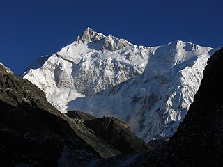 3. Kangchenjunga, the second-highest mountain of the Himalaya

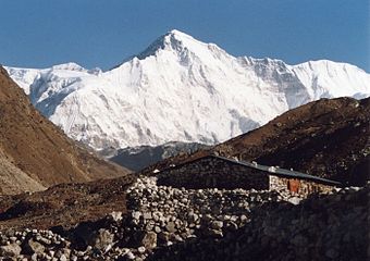
 7. Dhaulagiri in the Himalaya
 9. Nanga Parbat in the Himalaya
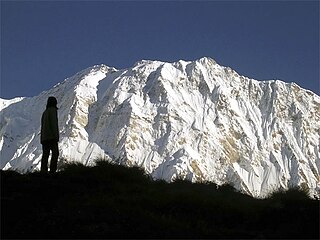 10. Annapurna I in the Himalaya
 11. Gasherbrum I, the second-highest mountain of the Karakoram
 12. Broad Peak, the third-highest mountain of the Karakoram
 13. Gasherbrum II in the Karakoram
 14. Shishapangma in the Himalaya


