
Buna (Adriatic Sea)
A request that this article title be changed to Buna (river) is under discussion. Please do not move this article until the discussion is closed. |
| Bojana Buna | |
|---|---|
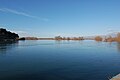
 Buna River near Shkodër | |
| Native name |
|
| Location | |
| Countries | Albania and Montenegro |
| County | Shkodër (Albania) |
| Municipality | Shkodër (Albania) Ulcinj (Montenegro) |
| City | Shkodër (Albania) |
| Physical characteristics | |
| Source | Lake Skadar |
| Mouth | Adriatic Sea |
• coordinates | 41°50′50″N 19°22′18″E / 41.84722°N 19.37167°E |
| Length | 41 km (25 mi) |
| Basin size | 19,582[1] km2 (7,561 sq mi) |
| Discharge | |
| • average | 672[1] m3/s (23,700 cu ft/s) |
| Basin features | |
| Tributaries | |
| • left | Great Drin |
| Designation | |
| Official name | Lake Shkodra and River Buna |
| Designated | 2 February 2006 |
| Reference no. | 1598[2] |
The Bojana (Cyrillic: Бојана) river, also known as Buna (Albanian: Bunë),[3] is a 41-kilometre-long (25 mi) river in Albania and Montenegro which flows into the Adriatic Sea. An outflow of Lake Skadar measured from the source of the lake's longest tributary, the Morača, the Morača-Shkodra Lake-Bojana system is 183 km (114 mi) long.
Name
The modern Albanian name Buna is derived from Illyrian Barbanna and follows Albanian phonetic sound rules.[4][5][6]
According to Serbian linguist Milivoj Pavlović, the derivation of the Slavic form Bojana from Barbanna is too complex and unconvincing. Instead, his hypothesis is that the hydronym Bojana is derived from the name of the Boii, an ancient Celtic tribe predating the Slavic migrations to the Balkans. The current name Bojana would have evolved from an earlier form *Boviana.[dubious ][7][better source needed]
History
The river appears as the Fiume Boiana in a 1688 map of Montenegro, published by Vincenzo Coronelli. At the time, the Bojana river did not have any tributaries feeding into it. The presence of the Drin river having its own mouth into the Adriatic Sea on the map suggests that the Drin did not join the Bojana river until after 1688. Over time, the frequent changes in its course and water levels led to flooding of its banks and the surrounding plains. Such occurrences led to the slow decay of the Monastery of Saints Sergius and Bacchus, located right on the bank of the Bojana river.[8]
Course
This section needs additional citations for verification. (June 2010) |
The river in Albania
The river used to be longer, but due to a rise in the level of Lake Skadar, the uppermost part of the river is now under the lake's surface. The river initially flows east, but after only few kilometers reaches the city of Shkodër and turns to the south. On the southern outskirts of the city, the river receives its most important tributary, the Great Drin, the greater part of which became its tributary after changing course during a flood in 1858 and now brings more water (352 m³/s) than the Buna itself (320 m³/s). After flowing around the Peak of Tarabosh, it passes through the villages of Zues, Bërdicë, Darragjat, Oblikë, Obot, Shirq, Dajç and Goricë.
Border river
After 20 kilometres (12 mi) in Albania, it forms the border between Albania and Montenegro. On this border section, which is 24 km (15 mi) long, the river meanders widely, flowing around Lakes Šas and Zogajsko blato, both in Montenegro. Settlements include villages of Sveti Đorđe and Reč on the Montenegrin, and Luarzë and Pulaj on the Albanian side. The area surrounding the river in this section is low and marshy, with the Bojana river being the eastern border of the Field of Ulcinj and of the 12-kilometre-long (7.5 mi) Long Beach (Velika Plaža) of Ulcinj.
Delta
At its mouth into the Adriatic, Buna forms a small delta with two arms, the left one forming the border with Albania, and the right one, with the island between the arms, being part of Montenegro. The island is called Ada Bojana (Ada, the Turkish word for "island", has found its way into the Serbian language). It was supposedly formed around a ship's wreck in the 19th century, and now covers an area of 6 km2 (2.3 sq mi), and is Montenegro's largest island. With the neighboring resort of Sveti Nikola ("Saint Nicholas"), it is a major center of nudism along the Adriatic.
The other, smaller island belongs to Albania and is called Franc Jozeph Island or Ada Major. This small island is not artificial such as Ada Bojana but natural. The Island of Franz Joseph frequently receives tourists.
Characteristics
The river has a large drainage basin of 5,187 km2 (2,003 sq mi). Lake Skadar, the largest lake in southeastern Europe, at almost sea level, nearby empties into it, draining much of Montenegro. From Albania, and border lands east, its main tributary is the Great Drin. Bojana river ranks second among all tributaries to the Adriatic (measured by average annual discharge) after the Po in Italy. Its mean discharge is c. 1,540 m3/s (54,000 cu ft/s).
It is highly navigable and is worked and toured by vessels ranging from motorboats, canal barges up to large tour boats and inland goods barges.
Gallery
-
 Aerial view the river's mouth, where it flows into the Adriatic
 -
 The Buna river in Shkodër, Albania


References
- ^ a b "The coastline of Albania : morphology, evolution and coastal management issues" (PDF). ciesm.org. p. 8.
- ^ "Lake Shkodra and River Buna". Ramsar Sites Information Service. Retrieved 25 April 2018.
- ^ "The Buna River- Velipojë Protected Landscape, BRPL Project". livingbuna.org. Retrieved 2023-01-21.
- ^ Demiraj, S. (2006). The Origin of the Albanians: Linguistically Investigated. Albanien: Academy of Sciences of Albania (p. 147)
- ^ Ismajli, Rexhep (2015). Eqrem Basha (ed.). Studime për historinë e shqipes në kontekst ballkanik (p. 474)
- ^ Katičić, Radoslav (1976). Ancient Languages of the Balkans. p. 186. ISBN 978-9027933058.
But on the main Albanian names such as Lesh, Drisht, Kunavja, Drin, Buenë, Mat and Ishm can be derived from their ancient forms Lissus, Drivastum, Candavia, Drinus, Barbanna, Mathis, and Isamnus only by Albanian sound changes, and by no others.
- ^ Pavlović, Milivoj (1966). "Les traces des Celtes en Illyricum" [Traces of the Celts in Illyricum]. In Blok, Dirk Peter (ed.). Proceedings of the Eighth International Congress of Onomastic Sciences. Amsterdam: Mouton. p. 374. ISBN 9783110995152.
- ^ Ožujski Živkov, Stanislav (2020). "Evidence for the architectural reconstruction of the church of Sts. Sergius and Bacchus (Kisha e Shirgjit) on the Bojana (Buna) River near Skhodra, Albania". Starohrvatska prosvjeta. 3 (47): 589–629. Retrieved 16 March 2024.
Bibliography
- Mala Prosvetina Enciklopedija, Third edition, Prosveta, 1985, ISBN 86-07-00001-2
- Jovan Đ. Marković, Enciklopedijski geografski leksikon Jugoslavije, Svjetlost-Sarajevo, 1990, ISBN 86-01-02651-6

| Town | |||||||||
|---|---|---|---|---|---|---|---|---|---|
| Villages |
| ||||||||
| Geography |
| ||||||||
| Landmarks |
| ||||||||
| Hotels | |||||||||
| Sports clubs | |||||||||
| Sports grounds | |||||||||
| Events | |||||||||
| Authority control databases: National |
|---|