Jhinjhak
Jhinjhak | |
|---|---|
Town | |
 | |
| Coordinates: 26°33′43″N 79°44′02″E / 26.562°N 79.734°E | |
| Country | |
| State | Uttar Pradesh |
| District | Kanpur Dehat district |
| Lok Sabha constituency | Kannauj |
| Assembly constituency | Rasulabad |
| Founded by | British rule |
| Government | |
| • Chairman | Sarojini devi |
| Elevation | 131 m (430 ft) |
| Population (2011 est.) | |
• Total | 45,000 |
| Languages | |
| • Official | Hindi |
| Time zone | UTC+5:30 (IST) |
| PIN | 209302 |
| Telephone code | 05114 |
| Vehicle registration | UP-77 |
| Website | http://kanpurdehat.nic.in/ |
Jhinjhak is a town and a Nagar Palika Parishad in Kanpur Dehat District in the Indian state of Uttar Pradesh. The town is situated on the banks of the Lower Ram Ganga canal.
History
Jhinjhak Nagar Panchayat was created on 11 January 1916 by the British Government.[citation needed] In 1972 its boundaries expanded to include nearby villages "Turana" and "tikan Gaon" .[1] In 2016 Jhinjhak became the Nagar Palika Parishad and its area also expanded including some more nearby villages.[1]
Ram Nath Kovind India's 14th President was born in the near by village Paraunkh. The President visits Jhinjhak to meet his brothers who live in the town.[citation needed]
Transport
Railway Station:-
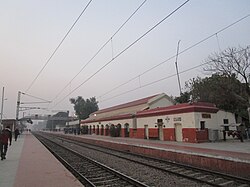
Jhinjhak is a railway station
on (NCR)/North Central Railway line on Howrah Delhi major train route of country. Direct trains for Kanpur, Lucknow, Allahabad Patna, Gaya, Howrah, Agra, Aligarh Delhi Amritsar Ambala Jammu are available.Further Kanpur Central station is just 63 km away from where trains for so many major cities of country are available.
Road:-
The city is situated between two major National Highways and Expressway. Lucknow Agra Expressway is approximately 50 km from city. And NH2 National Highway is only 25 Km. The city is also well connected with nearby cities like Auraiya Kannauj and Kanpur by good roads.
Airport:-
Lucknow Airport is the nearest major Airport which is well connected with major cities of country and with some International Destinations. Other airport is Kanpur Chakeri which is also connected with several domestic cities. These airports are located at approximate 2 hours distance. Delhi International Airport is approximately 5 hours distance.
Devotional places
- Akshayvat Akhaivar Temple[2]
- Jai Mata Di Temple
- Shiva and Hanuman temple at Chota Chouraha
- Sati Maa temple, Basti
- Banjreswar baba, kamaihela
Demographics
As per the census 2011 Jhinjhak had a population of 24,027. Males constitute 52.64% of the population and females 47.36% with a sex ratio of 899 female/1000 males. The Schedule Caste (SC) population within the Jhinjhak Nagar Panchyat is 18.57% of the total population with a sex ratio of 896 female/1000 males. Schedule Tribe (ST) population in the area is 0.054% out of a sex ratio of 625 female/ 1000 male. The total number of literate within the study area is 17874 which are 74.39% of total population. Male literacy rate of the study area is 55.99% and female literacy rate is 44.01%.
References
External links
- Jhinjhak at India9.com

