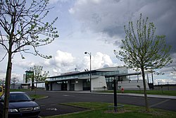
Angers – Loire Airport
Appearance
Angers – Loire Airport Aéroport de Angers – Loire | |||||||||||||||||||
|---|---|---|---|---|---|---|---|---|---|---|---|---|---|---|---|---|---|---|---|
 | |||||||||||||||||||
| Summary | |||||||||||||||||||
| Airport type | Public | ||||||||||||||||||
| Operator | Société de Gestion de l'Aéroport Angers-Marcé (SGAAM) | ||||||||||||||||||
| Serves | Angers, France | ||||||||||||||||||
| Location | Marcé, France | ||||||||||||||||||
| Elevation AMSL | 59 m / 194 ft | ||||||||||||||||||
| Coordinates | 47°33′37″N 000°18′44″W / 47.56028°N 0.31222°W | ||||||||||||||||||
| Website | AngersLoireAeroport.fr | ||||||||||||||||||
| Map | |||||||||||||||||||
Location of airport in Pays de la Loire | |||||||||||||||||||
| Runways | |||||||||||||||||||
| |||||||||||||||||||
Angers – Loire Airport (French: Aéroport de Angers – Loire, IATA: ANE[2], ICAO: LFJR) is an airport located in Marcé, 20 kilometres (11 nautical miles) northeast of Angers,[1] both communes of the Maine-et-Loire department in the Pays de la Loire region of France. It is also known as Angers – Marcé Airport (French: Aéroport d'Angers – Marcé).
Facilities
The airport resides at an elevation of 194 feet (59 m) above mean sea level. It has one asphalt paved runway designated 08/26 and measuring 1,800 by 45 metres (5,906 ft × 148 ft). It also has two grass runways: 08L/26R is 720 by 50 metres (2,362 ft × 164 ft) and 08R/26L is 1,100 by 100 metres (3,609 ft × 328 ft).[1]
Airlines and destinations
| Airlines | Destinations |
|---|---|
| British Airways operated by BA CityFlyer | Seasonal: London-City |
| British Airways operated by Eastern Airways for BA CityFlyer | Seasonal: London-City |
| IGavion operated by SkyTaxi | Seasonal: Nice, Toulouse |
References
- ^ a b c LFJR – Angers Marcé. AIP from French Service d'information aéronautique, effective 13 June 2024.
- ^ "IATA Airport Code Search (ANE – City: Angers, Airport: Marce)". International Air Transport Association. Retrieved 9 August 2013.
External links
- Angers Loire Aéroport, official site Template:Fr icon
- Aéroport d'Angers Loire at Union des Aéroports Français Template:Fr icon
- Aeronautical chart and airport information for LFJR at SkyVector
- Current weather for LFJR at NOAA/NWS


