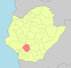
Yongkang District
23°01′N 120°15′E / 23.017°N 120.250°E
Yongkang
永康區 | |
|---|---|
| Yongkang District | |
 Yongkang District's location in Tainan | |
 | |
| Country | Taiwan |
| Special municipality | Tainan |
| Government | |
| • Mayor | Wang Jyun-ming (王峻明) |
| Area | |
• Total | 40.28 km2 (15.55 sq mi) |
| Population (January 2016) | |
• Total | 230,957 |
| • Density | 5,700/km2 (15,000/sq mi) |
| Website | English Chinese |


Yongkang District (Chinese: 永康區; pinyin: Yǒngkāng Qū; Pe̍h-ōe-jī: Éng-khong Khu) is a district in Tainan, Taiwan.
History
Due to the development of manufacturing and food-processing industries, Yongkang has become a migrant city since the 1970s, attracting many people from neighboring cities who now work and live in the city. Its population experienced a large increase during the 1970s, and Yongkang became the largest city in Tainan County in 1977.
Yongkang was formerly the largest city of Tainan County until it merged with Tainan City to form the new Tainan municipality and became Yongkang District on 25 December 2010.
Though the increase in population today is not as rapid as it was before, Yongkang still enjoys the steady growth envied by other cities or towns.
Education
- Kun Shan University
- Southern Taiwan University of Science and Technology
- Tainan University of Technology
Tourist attractions
Transportation
Rail

Road
Hospitals
Galleries
-
Yongkang Park
-
Border between Yongkang District and East District
-
Yongkang Exploring and Educating Park
See also
References
- ^ "Archived copy". Archived from the original on February 21, 2014. Retrieved February 9, 2014.
{{cite web}}: Unknown parameter|deadurl=ignored (|url-status=suggested) (help)CS1 maint: archived copy as title (link)


