The '''Missoula Metropolitan Statistical Area''' is the second largest metropolitan area in the U.S. state of Montana. Located in the West-central portion of the state, its population was 95,802 at the [[2000]] [[census]]. As of July 1, [[2009]] the estimate of [[Missoula Metropolitan area]] was 108,623.<ref name="Missoula County, Montana"/>
The '''Missoula Metropolitan Statistical Area''' is the second largest metropolitan area in the U.S. state of Montana. Located in the West-central portion of the state, its population was 95,802 at the [[2000]] [[census]]. As of July 1, [[2009]] the estimate of [[Missoula Metropolitan area]] was 108,623.<ref name="Missoula County, Montana"/>
It is one of the largest metropolitan areas between [[Ogden, Utah]], and [[Calgary]], Alberta [[Canada]], and [[Spokane Valley, Washington]], and [[Billings, Montana]]. It is also the second largest media market in the state of Montana, and also has one of the best Health care facility programs in its surrounding area.
It is one of the largest metropolitan area between [[Boise, Idaho]], and [[Calgary]], Alberta [[Canada]], and [[Spokane, Washington]], and [[Billings, Montana]]. It is also the second largest media market in the state of Montana, and also has one of the best Health care facility programs in its surrounding area.
{{USCensusPop
{{USCensusPop
Revision as of 03:27, 23 December 2010
"Missoula" redirects here. For a ship in the United States Navy, see USS Missoula.
This article is about the city. For the glacial age lake, see Glacial Lake Missoula.
Missoula (pronounced/mɨˈzuːlə/), located in the west-central portion of Montana is a city in and the county seat of Missoula County, Montana, United States. The US Census Bureau's 2009 estimate of Missoula's population was 68,876;[1] making Missoula, Montana the second largest city in Montana. The 2009 census estimate put the population of Missoula County at 108,623.[2].
Missoula was founded in 1860 as Hellgate Trading Post before being renamed Missoula Mills (Missoula from the Salish name for the area Nemissoolatakoo and Mills after the prosperous flour mill and sawmill that served as Missoula’s first industry). Mills was dropped from the name and in 1877, Ft. Missoula’s establishment ensured the survival of the city.[3]
Missoula’s nickname is the Garden City in reference to the large number of orchard homes that once lined its periphery and an extensive vegetable and flower garden owned by Cyrus and William McWhirk that formed the eastern entrance to the city.[4][5]
Though founded as a lumber and agricultural center as well as a trading post, the basis of Missoula’s economy today is the University of Montana, government, healthcare, tourism, and professional services.[6]
In addition to the University of Montana, Missoula is, perhaps, best known for being the most politically liberal city in Montana, the birthplace of first woman elected to the U.S. Congress, Jeannette Rankin, and the home of Montana’s largest brewery.
History
Earliest Missoula
Teepees set up in modern-day Missoula south of the Clark Fork River, facing east
As a natural corridor through the mountains, the valley was the scene of great conflict between local Native American Tribes and those traversing the region to and from Montana’s eastern plains which were rich with Buffalo. The narrow valley at Missoula’s eastern entrance was so strewn with human bones from repeated ambushes that French fur trappers would later refer to this area as “Porte d’ Enfer,” translated as Hell’s Gate. Hell Gate would remain the name of the area until renamed Missoula in 1866.[8]
Early Explorers
The first European Americans to visit what would become Missoula were members of the Lewis and Clark Expedition. The expedition stopped twice just south of Missoula at Traveler’s Rest; first from Sept. 9-11, 1805 and again from June 30-July3, 1806.[9] It is from here that the Lewis and Clark Expedition divided on the return from the Pacific with Clark taking the southern route along the Bitterroot River and Lewis travelling north through Hellgate Canyon on July 4.[10]
Missoula Barracks in 1887.
The region was first surveyed by Washington Territory governor Isaac Stevens in the 1850’s by Congressional request as a means of developing a transcontinental rail route. He would also negotiate the Treaty of Hellgate through which the Native American tribes of Western Montana relinquished their territories to the U.S. government. Steven’s was assisted by Lieutenant John Mullan who would build the Mullan Road in 1853, the first wagon road to cross the Rocky Mountains to the Inland of the Pacific Northwest, which would enable the establishment of Fort Missoula in 1877. [11]
Settlement in Missoula began five miles west near modern Frenchtown in 1860 as a trading post founded by Christopher P. Higgins, who had been present at the Treaty of Hellgate, and business partner Francis L. Worden with the expectation that Mullan Road and any future railroad would necessarily pass through the valley. Their gamble was correct and Hell Gate became the Missoula County seat in 1860 and the first post office established November 25, 1862, with Worden as the first postmaster.[12] The settlement moved upstream to its modern location in 1864 as Higgins and Worden’s desire to build a lumber and flourmill required a more convenient water supply to power the gristmill.[13]
The Missoula Mills replaced Hell Gate Village as the economic power of the valley and replaced it as the county seat in 1866. The name Missoula comes from the Salish name for the Clark Fork River which runs through the city. The name ‘’nmesuletkʷ’’, though often mistakenly believed to translate as “River of Ambush” as a reflection of the inter-tribal fighting common to the area, the word actually has the approximate meaning of "place of freezing/cold liquid", or more roughly "cold water" (cf. Interior Salishan locative marker n-, Southern Interior Salishan sul, 'cold/frozen', and -etkʷ, 'liquid'). This name is thought by some Salish tribal members to refer to Glacial Lake Missoula.
Missoula never “boomed” as many western Montana towns did as a consequence of the gold rush, though the town did grow rapidly and by 1872, the town had 66 new buildings. Higgins and Worden established the towns first stores and banks, but by 1876 the pair faced its largest competition and rivalry from Eddy, Hammond and Company who established the Missoula Mercantile Company.[14]
By the 1880’s growth had slowed, but the arrival of the Northern Pacific Railway in 1883 caused the town to boom and Territorial Governor Benjamin F. Potts approved a charter for the Town of Missoula. The need for lumber for the railway and its bridges spurred the opening of multiple saw mills in the area and the beginning of Missoula’s lumber industry. The economic frenzy led to the construction of many of the historic buildings in downtown today. In particular, architect A. J. Gibson arrived in the late 1880’s and designed many of Missoula’s most recognizable buildings, including the Missoula County courthouse and the University of Montana’s Main Hall.[15]
In an agreement with Helena that Missoula would not enter a bid to become the new state of Montana’s new capital and not openly support nearer by Anaconda Missoula was able to win the vote to be the home of the state’s university in 1893. Land south of the Clark Fork River (Downtown had established itself north of the river) was donated for the construction of a campus.[16]
20th Century
The continued economic windfall from railroad construction and lumber mills led to a further boom in Missoula’s population. A.B. Hammond and Copper KingsMarcus Daly and William A. Clark competed fiercely in the region over lumber share and Missoula investments and in 1908 Missoula became the district and later a regional headquarters for the United States Forest Service which also began training smokejumpers in 1942.
In the 1930’s Missoula was able to obtain fourteen Civil Works Administration projects that helped build the Airport, Orange Street Bridge, several schools, and four major buildings at the university.[17]
Logging remained a mainstay of industry in Missoula with the groundbreaking of Hoerner-Waldorf pulp mill in 1956 which led to subsequent protests over the resultant air pollution.[18] Still, in 1979, almost 40% of the county's labor income came from the wood and paper products sector.[19] By the early 1990’s, however, many of the region’s log yards and legislation had cleaned the skies, though the valley’s topography still makes the city susceptible to lingering smoke from forest fires and winter smog.[20]
Population
Unlike most towns in Montana; Missoula never truly had any time of population spike, until the 1990's. Since 1990 the U.S Cencus has seen a small population spike in Missoula. In 1990 the population of Missoula was 42,918, or the same as a fairly average american city. the 2009 population estimate is sitting at 68,876. So since 1990 Missoula has seen a growth of more than 25,000 people; which is a pretty large increase in 20 years. The percantage increase since 1990 is 53.6%.
According to the United States Census Bureau, the city has a total area of 23.9 square miles (61.9 km²), of which 23.8 square miles (61.6 km²) is land and 0.1 square miles (0.3 km²) (0.46%) is water. Missoula is located in a deep valley in the western part of the state, near where the Clark Fork River is joined by the Bitterroot and Blackfoot Rivers.
Ancient wave-cut shorelines can still be seen on the edge of Mount Sentinel. Where the University of Montana now stands, the lake was once 950 feet deep
During the last Ice Age, the Purcell lobe of the Cordilleran Ice Sheet blocked the Clark Fork river near what is now Clark Fork, Idaho creating Glacial Lake Missoula which extended approximately 320 kilometers (200 mi) eastward, filling the Missoula Valley and connecting today's Flathead and Pend Oreille Lakes. The ice dam holding back waters periodically thawed and refroze causing the Missoula Floods that swept across Eastern Washington and down the Columbia River Gorge approximately 40 times during from 15,000 to 13,000 years ago leaving behind giant ripple marks across the valley.[22] These 15-30 foot ripple marks were first noted as evidence of the rapid draining of Glacial Lake Missoula by USGS employee Joseph Pardee in his 1942 publication Unusual Currents in Glacial Lake Missoula and supporting J Harlen Bretz's popularly dismissed 1923 theory of the Missoula Floods forming the Channeled Scablands of Eastern Washington.[23]
Evidence of the city of Missoula's lake bottom past can be seen in the form of ancient wave-cut shorelines that can now be seen as horizontal lines on nearby mountains Mount Sentinel and Mount Jumbo.[24] At the location of present-day University of Montana, the lake once had a depth of 950 feet.[25]
Terrain
As could be expected for a former lake bottom, the layout of Missoula is relatively flat and surrounded by steep hills. The Clark Fork River enters the Missoula Valley from the east just after it joins with the Blackfoot River at the site of the former Milltown Dam. The Bitterroot River and multiple smaller tributaries join the Clark Fork after the river enters Missoula.
Missoula has a semi-arid climate (Koppen climate classificationBSk), with cold and moderately snowy winters, hot and dry summers, and spring and autumn are short and crisp in between. Winter conditions are usually far milder than much of the rest of the state due to its western position within the state. However the mildness is also induced by the dampness, as unlike much of the rest of the state, precipitation is not at a strong minimum during winter. Winter snowfall averages 43 inches (109 cm), with most years seeing very little of it from April to October. Summers see very sunny conditions, with highs peaking at 84 °F (28.9 °C) in July. However, temperature differences between day and night are large during this time and from April to October, due to the relative aridity.
1996 winter
In the winter of 1996, Missoula suffered the worst winter in its history. For the winter of 1996 Missoula received more than 200 inches of snow, and experienced more than 70 days with snow. This year is known also for extreme coldness. In November of 1996 there were 7 days where the temperature dropped below zero degrees F. In December 1996 12 days fell below zero. In January 1996 there were 11 days in which the temperature fell below zero, and in February there were 3 days where the temperature fell below zero. Combined there were 33 days in the winter of 1996 that the temperature fell below zero in Missoula, Montana.
Downtown Missoula in the winter of '96
Winter of 1996 statistics
November 1996
December 1996
January 1996-7
February 1996-7
November High Temp.
December High Temp.
January High Temp.
February High Temp.
55 Fahrenheit
45 Fahrenheit
45 Fahrenheit
46 Fahrenheit
November Low Temp.
December Low Temp.
January Low Temp.
February Low Temp.
12 Fahrenheit
0 Fahrenheit
-11 Fahrenheit
-2 Fahrenheit
November snowfall
December snowfall
January snowfall
February snowfall
10.0 inches
27.0 inches
13.0 inches
10.0 inches
City Layout
In the Mid-1860's C.P. Higgins and Francis Worden began plotting what would become the town of Missoula along the Mullan military road along the northern bank of the Clark Fork River. This road, which today in downtown Missoula is known as Front St. was then intersected by Higgins Ave. which continued as a bridge to the southern side of the river. From this intersection of Higgins and Front, which continues as the numerical center of the city, development spread along the road with homes to the north toward the surrounding hills. The arrival of the railroad in 1883 brought with it a rapid increase in population which settled along the track. When the university was founded in 1893, the land donated for its cause south of the Clark Fork was still little more than farm land.[32] Development continued east along Mullan Road and south along the road to Lolo, Montana which today is known as Brooks St.
The city primarily follows a standard north-south grid pattern, though newer subdivisions and residential areas located on hills often do not follow the established pattern. Notable exceptions to the grid pattern are Downtown where the grid follows the contour of the river and a section of the Rose Park Neighborhood where the grid instead aligns with Brooks St. (Highway 12), one of only two arterials (the other being Stephens Ave.) to traverse the city diagonally. The Bitterroot Branch of Montana Rail Link also traverses Missoula diagonally south of the river while the main branch as well as Interstate-90 move with the river and hill's terrain north of the Clark Fork.
Neighborhoods
The city of Missoula is divided into eighteen neighborhood councils of which all Missoula residents are a member.[33]
Neighborhood
General Location within Missoula
Notable Features
Captain John Mullan
Northwest, South of the railroad
More commonly known as the west side of North Reserve. This is part of Missoula's "Big-box store" district with an adjacent housing development.
Fairviews/ Pattee Canyon
Extreme Southeast hills and canyon
Surrounds the Highlands Golf Club and is adjacent to the undeveloped land of Pattee Canyon
Rural northeast hills and forest nearest Mount Jumbo
Westside
Northwest, North of the river, South of the railroad
redevelopment commercial area
Downtown
Downtown's birth
Downtown Missoula became a permanent spot in Missoula ever since Missoula has been a city. Downtown started in the late 1890s and has been rapidly growing ever since. Downtown Missoula's main burst of steam was when A.J Gibson moved to Missoula with ideas for growth in the small town.[34] A.J Gibson virtually consrtucted and designed every historic building in Downtown Missoula including the Missoula County Courthouse in 1908, and the Wilma Building that was the first steel-framed structure in Montana at its completion in 1921.
The famous Wilma Building in Downtown Missoula
After the A.J Gibson era Downtown Missoula grew at a steady pace until the Modern era. The Modern era is concluded from the 1990s to present day. the start of the Modern era all began when all the log yards in Missoula; that was Missoula's economy at one time totally vanished. once logging had became the past the Missoula Downtown Association was born and the realDowntown Missoula became to what it is today. with the completion of the First Interstate Bank, the First Security Bank, the new St. Patrick Hospital and Health Sciences Center, and the tallest Building in Missoula, the Millennium Building.
Enlarging Downtown
The Downtown Missoula District has been growing rapidly in the past couple of decades, due to tourism and relocation movements. Downtown has had numerous new small businesses move into the area, and several organizations. One of these organizations which started right in Downtown itself; the Missoula Downtown Association (MDA)[35] has been a very large organization lately in Downtown Missoula, which formed in 1975 and it has organized almost anything that has recently met together in Missoula for the past several decades. With the help of the Missoula Downtown Association, downtown's main venue recently has been Caras Park, which is right next to the heart of Downtown Missoula, and the Missoula carousel.
Architecture
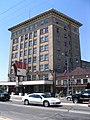
Missoula is home to over 60 buildings on the National Register of Historic Places beginning with the A.J. Gibson designed County Courthouse constructed in 1908 and added to the list in 1976. The Post Office, Wilma Theatre and Higgin's Block were all added a couple years later. In the early 1990's both the Gleim Building, a former brothel, was added to the list along with the University District.[36]
The Missoula Metropolitan Statistical Area is the second largest metropolitan area in the U.S. state of Montana. Located in the West-central portion of the state, its population was 95,802 at the 2000census. As of July 1, 2009 the estimate of Missoula Metropolitan area was 108,623.[2]
It is one of the largest metropolitan area between Boise, Idaho, and Calgary, Alberta Canada, and Spokane, Washington, and Billings, Montana. It is also the second largest media market in the state of Montana, and also has one of the best Health care facility programs in its surrounding area.
As of the censusTemplate:GR of 2000, there were 57,053 people, 24,141 households, and 12,336 families residing in the city. The population density was 2,397.1 people per square mile (925.6/km²) in 2000. There were 25,225 housing units at an average density of 1,059.8/sq mi (409.2/km²). The racial makeup of the city was 93.57% White, 2.35% Native American, 1.23% Asian, 0.36% African American, 0.10% Pacific Islander, 0.51% from other races, and 1.87% from two or more races. Hispanic or Latino of any race were 1.76% of the population.
There were 24,141 households out of which 24.6% had children under the age of 18 living with them, 37.9% were married couples living together, 10.0% had a female householder with no husband present, and 48.9% were non-families. 33.6% of all households were made up of individuals and 8.9% had someone living alone who was 65 years of age or older. The average household size was 2.23 and the average family size was 2.88.
In the city the population was spread out with 19.7% under the age of 18, 20.7% from 18 to 24, 29.4% from 25 to 44, 19.8% from 45 to 64, and 10.4% who were 65 years of age or older. The median age was 30 years. For every 100 females, there were 98.8 males. For every 100 females age 18 and over, there were 97.1 males.
The median income for a household in the city was $30,366, and the median income for a family was $42,103. Males had a median income of $30,686 versus $21,559 for females. The per capita income for the city was $17,166. About 11.7% of families and 19.7% of the population were below the poverty line, including 20.5% of those under age 18 and 9.3% of those age 65 or over. 38% of Missoula residents age 25 and older have a bachelor's or advanced college degree.
Economy
Unemployment rate
Missoula's unemployment rate is one of the lowest in the state of Montana, currently at 6.6%.
As of October 2010 Trade, Transportation, and Utilities is the largest job sector in Missoula, accounting for 12.0% of jobs. The next largest category is Government jobs, accounting for 10.0% of the workforce. The third largest is Education and Health Services at 9.5%, and after this is Leisure and Hospitality at 7.3%. The fifth largest sector is Professional and Business Services at 6.7%.[40]
Missoula is home to the Missoula Convention and Visitors Bureau, which was founded in 2003. The Missoula Convention and Visitors Bureau has been formed exclusively for the promotion of tourism, the development of effective methods of attracting and hosting conventions and events for Missoula and the surrounding area, and to educate the local community of the significance of the tourism as an economic driver. The promotion and development was a huge part in the making of this organization.
Southgate Mall
One of the most popular shopping destinations in the state, and servicing over 7 million customers each year, Southgate Mall is currently the largest enclosed regional shopping center of its kind in all of Western Montana.
Local attractions
Missoula is located near the Rattlesnake Wilderness and Rattlesnake National Recreation Area, two areas that protect Missoula's municipal watershed and serve as wildlife habitat and recreational areas. The Forest Service'ssmokejumper base, the largest of its kind, is located near the Missoula airport. Free tours of the base are popular with tourists during the summer wildfire season. A walking bridge over the downtown yards of the Montana RailLink railroad is a popular destination for railfans.
Culture
Arts
Missoula has a thriving arts scene. The International Wildlife Film Festival,[41] the largest animal-themed film festival in the world, is held annually at the historic Wilma Theatre. The Missoula Children's Theater[1] is an international touring program that visits nearly 1,000 communities per year. The Children's Theater routinely has residencies in all fifty states, Canada, Japan, Germany, Italy, and many other countries. The Missoula Art Museum[2], exhibits a variety of contemporary art. The museum was founded in 1975, and in 2005 the facilities were renovated and expanded. The museum offers art classes, tours, gallery talks, and has free admission.
The University of Montana is a state university located in Missoula, Montana, U.S. The school was founded in 1893. It is the largest campus in the five-campus University of Montana System.
The Caras Park Pavilion, located in the heart of Downtown Missoula on the Clark Fork River, is the epicenter of Downtown Missoula.with the help of the Missoula Downtown Association, Caras Park has been the main venue to these yearly events:[43]
Caras Park in the centre of Downtown Missoula
Out to Lunch
Downtown ToNight
Garden City River Rod
International Wildlife Film Festival
WildFest
Parks & Recreation Kids Fest
YMCA Riverbank Run
First Night Missoula
Garden City BrewFest
Hemp Fest
GermanFest
Concerts by Jewel
Chris Isaak
Los Lobos
Santana
Ziggy Marley and
B.B. King
Adjacent to Caras Park is A Carousel for Missoula, a wooden, hand-carved and volunteer-built carousel.
Outdoor activities
Missoula is an outdoor enthusiast's paradise throughout the entire year. Throughout the year, activities like skiing, hiking, biking, golf and fly fishing are available.
Missoula biking system
Missoula is a focal point of bicycle travel, because of the presence of Adventure Cycling Association,[44] North America's largest cycling membership organization. Thousands of bike travelers come through Missoula and stop at Adventure Cycling's downtown headquarters (in a former church at 150 E. Pine Street) for free ice cream, advice, and the chance to be photographed.
Government and politics
Missoula is governed via the mayor-council system. There are twelve members of the city council who are elected from one of six wards. Each ward elects two council members. The mayor is elected in a citywide vote.[45]
Missoula is known as a more liberal area than the rest of the state, having 14 Democrats and one Republican in its state legislative delegation.[46] Missoula's Mayor has been John Engen since 2006 and is currently the 50th mayor of Missoula, MT[47]
Currently the City of Missoula is undergoing a rewrite of the zoning and subdivision regulations, is undertaking a study of the Urban Fringe Development Area (UFDA), is working in partnership on the Downtown Master Plan, and is finalizing a long-range transportation plan.
In 2006, voters in Missoula County passed Initiative 2, which made marijuana possession the lowest priority for law enforcement. However, in 2008 a volunteer citizen committee[49] established to oversee progress on the initiative found that marijuana arrests rose in the 2 years since its passage. It also concluded, "In short, the lowest priority recommendation issued to public officials by voters in 2006 continues to be
mostly disregarded."[50]
City police chief Mark Muir defended criticism of the rising number of arrests, saying the rise could be attributed to "some people [being] more flagrant in their pot smoking because they wrongly believe the initiative protects them within the city."[51]
Most of the legislative districts that approved of medical marijuana overwhelmingly include the city of Missoula within their boundaries.[52]
A statewide chapter[53] of NORML was founded in 1998 and is based out of Missoula.
Missoula is also home to Missoula Correctional Services a non-profit company that runs a Pre-Release Center for the Montana Department of Corrections and coordinates various city and county programs such as Community Service, Misdemeanor Probation, Pretrial Supervision and the Alternative Jail Program.
The Worst Traffic is usually centered around U.S highway 93/Reserve St.; which is a 4 (at times 5 lane) major street considered a mini-highway at times. The trafiic is worst on weekday evenings where it is the most used street to get around in most of Missoula. The traffic along Orange st. intersections, and Downtown Missoula intersections also cause traffic problems in Missoula. In the Winter season, traffic can also be a problem due to Missoula's snowy and icy winter's.[citation needed]
Reported Crashes
The Missoula Police Department (MPD) responds to approximately 1,800 reported crashes per year, which is the most in a Montanacity. The highest and most severe crash rates taking place are along U.S. 93 / Reserve St., which is the epicenter for traffic for Missoula.[citation needed]
14% of all reported crashes are alcohol related, which is about average with the state and national average. Since 2003, the department has made DUI enforcement and traffic enforcement a major priority, increasing the DUI arrests from 358 to a high of 873 in five years.[citation needed]
There is a network of bicycle and pedestrian trails throughout the community, and there is a large population that walks and bike for pleasure and commuting.
Greyhound bus that transit(s) Missoula
A number of transportation-oriented organizations are located in Missoula as well. The Bike/Walk Alliance for Missoula[56] aims to enhance biking and walking in Missoula. Missoula in Motion[57] operates an incentive-based program for commuters who choose not to drive alone, and the Missoula Ravalli Transportation Management Association provides vanpool and other transportation demand management services. Missoula is also home to Greyhound Lines, and Rimrock Trailways provide intercity bus transportation to and from Missoula.
The Missoula International Airport (Johnson-Bell Field) is a vital part of the western Montana regional airport system and an integral part of the transportation infrastructure of the region. The airport and surrounding area provide visitors arriving by air, with a favorable first impression of Montana.
The Missoula International Airport is a commercial service airport serving a diverse aviation community. Scheduled airline and air taxi service, military, U.S. Forest Service, general aviation, cargo operations, and recreational flying are the major aviation activities.
Delta Airlines, Horizon, Northwest Airlines, United Express, and Allegiant Airlines serve the Missoula International Airport.
Other services
There is no passenger rail service in Missoula, but there is an ongoing effort to restore such service along the former North Coast Hiawatha route. This route, operated by Amtrak until 1979, passed through Missoula and several other Montana cities.
The following major highways pass through Missoula:
HistorySt. Patrick Hospital opened in 1873 under the sponsorship of the Sisters of Providence. The present facility opened in 1984, the fourth St. Pat's on this site above the Clark Fork River. In May 2000, they changed the name from "St. Patrick Hospital" to "St. Patrick Hospital and Health Sciences Center" to reflect an increasing involvement with national medical research and education. The hospital has 195 acute-care beds, and 18 transitional-care beds. In 2003, St. Pat's admitted over 9,705 patients and provided more than 49,986 days of patient care. Approximately 95% of patients come from our 17-county service area.
In November 1999, after imploding the old hospital called the Broadway Building, construction began for a new outpatient services building next to our present hospital building. The Broadway Building opened in March 2002, with two underground floors of parking and six stories of physician offices and outpatient services. Physicians include those from the Western Montana Clinic, the Montana Neuroscience Institute, and the Montana Cancer Center, among others. Outpatient services include physical, occupational, and speech therapy, diabetes services, and cardiac rehabilitation.
Sponsorship
St. Patrick Hospital and Health Sciences Center is a not-for-profit medical center under the sponsorship of the Sisters of Providence. The Sisters share sponsorship responsibilities with community leaders in the form of a governing board, which helps direct the hospital in its endeavors. This governing board, in turn, reports to and is directed by Providence Health and Services. Providence Health and Services is a holding company that represents the Sisters of Providence in leading their sponsored healthcare, higher education, and human services ministries in eastern Washington and western Montana. Sponsorship is a special type of not-for-profit ownership. As sponsors, the Sisters of Providence and Providence Health and Services are accountable to the community, the Catholic Church, and state and federal governments for fulfilling the missions of each sponsored organization.[58]
Community Hospital
History
The Community Medical Center (Montana) and its adjacent medical facilities stand as a gleaming monument to the dedication and vision of hundreds of Montanans and, in particular, two doctors who came west in the early 1900s.
Situated on a grassy plain near historic Fort Missoula, Community Hospital is part of a modern complex that includes a nursing home, the Missoula Crippled Children's Center and private offices.
The story of Community Hospital begins with two brothers who were prominent in the early history of Western Montana medicine.
Dr. Charles Thornton (known affectionately as "Dr. Charles") came west in 1905 to begin a practice in Corvallis, Montana. At that time the mortality rate of spotted or "tick" fever was 80 to 90 per cent. Of the first 11 cases Dr. Charles treated, only one patient died. He subsequently became known throughout the Bitterroot Valley for his ability to treat the dreaded Rocky Mountain Spotted Fever.
An ardent sportsman, Dr. Charles was among the first to introduce Chinese and Hungarian pheasants to Western Montana. He also imported and bred German shorthaired pointers to hunt the wily pheasants. At one time, he had more than 30 German pointers in his kennels. Dr. Charles also imported Belgian horses and brown Swiss dairy cattle.
Dr. Charles' brother, Dr. Will Thornton ("Dr. Will") came west in 1907 and started a practice in Stevensville, Montana. He had been a professor of anatomy and had worked with Dr. J. H. Kellogg, the surgeon who established the Battle Creek sanitarium in Michigan. Dr. Kellogg was the older brother of W. K. Kellogg, who developed the corn flake into a multi-million-dollar industry.
Dr. Will performed more than 15,000 major operations in 36 years of active practice, and he participated in the construction and operation of three private hospitals in Western Montana.
In 1910 he built the first hospital in the Bitterroot Valley and ran it until 1917, when he moved to Missoula. At that time, he built the Thornton Hospital, now the Thornton Apartments at the corner of Third and Orange Streets.[59]
Utilities
In Missoula the following utilities of Power, water, sewer and garbage disposal are: Electricity is provided by Missoula Electric Cooperative or NorthWestern Energy, which also supplies natural gas service. Allied Waste services and Grant Creek Water Systems handles trash pickup. Telephone service in the area is proved by Qwest Communications and Blackfoot Telecommunications Group. Sewer services is handled by the City of Missoula Wastewater Division, and Alltel, Verizon, and Cellular One is the most used cell phone services in Missoula.
^Lutz, Dennis J. (1986). Montana Post Offices & Postmasters, p. 26, p. 35. Minot, North Daokta: published by the author & Montana Chapter No. 1, National Association of Postmasters of the United States.
^Allen, John Eliot (c1986). Cataclysms on the Columbia : a layman's guide to the features produced by the catastrophic Bretz floods in the Pacific Northwest. Portland, OR: Timber Press. p. 104. ISBN0881920673. {{cite book}}: Check date values in: |date= (help); Unknown parameter |coauthors= ignored (|author= suggested) (help)


 The Wilma Theater in Missoula Montana, built in 1921.
 Downtown Missoula Winter- 1996
 Missoula
 Historic Building in Downtown Missoula
 Missoula Sunset in Downtown Missoula
 Downtown Missoula
 Sunset over Missoula area


.jpg)
