
Bihać
Bihać | |
|---|---|
|
Coat of arms of Bihać Coat of arms | |
 Location of Bihać within Bosnia and Herzegovina. | |
| Country | |
| Government | |
| • Municipality president | Hamdija Lipovača (SDP) |
| Area | |
| • Total | 900 km2 (300 sq mi) |
| Population (est. 2006) | |
| • Total | 105,000 |
| Time zone | UTC+1 (CET) |
| • Summer (DST) | UTC+2 (CEST) |
| Area code | +387 37 |
| Website | http://www.bihac.org |


Bihać is a city and municipality on the Una River in the north-western part of Bosnia and Herzegovina, center of the Una-Sana Canton of the Federation of Bosnia and Herzegovina.
History
The town was first mentioned as early as 1260 as property of a church in Topusko, Croatia in a document by the Hungarian-Croatian king Bela IV, and became a free city in 1262. Bihać was the temporary capital of the Croatian Kingdom. It lost its civic status in the 14th century following dynastic struggles in the kingdom, and became a property of the Frankopan nobles. In the 16th century it passed under direct royal rule, when battles with the Ottoman Empire had begun. The town of Bihać, in the region of the same name, withstood the Ottoman attacks until it fell with the Bosnia sanjak (in 1592).
The Bihać fort would become the westernmost fort taken by the Ottoman army over a hundred years later, in 1592 under the Bosnian vizier Hasan-pasha Predojević, previous orthodox Bosnians - Valacchi (Vlah in Bosnian). The city was initially made the center of the Bihać sanjak, part of the Bosnian pashaluk. It was demoted in 1699 to become part of the sanjak of Bosnia, during the period of intense border wars between the Habsburg monarchy and the Ottoman Empire. In 1865 it became the center of its own sanjak, but this lasted only until 1878, when all of Bosnia was occupied by Austria-Hungary.
A period of peace followed, marked by the 1888 bringing down of the fortress walls that separated the inner city from the outskirts. The new government had several schools and civic facilities built, which boosted the city's growth. It remained prosperous after the establishment of Yugoslavia, the center of the western Bosnian region, though its growth was impaired by the Great Depression in the 1930s.
During World War II it served as headquarters for the liberation army of Josip Broz Tito, the seat of the first AVNOJ session in 1942 and the center of the anti-fascist resistance. As such, it became a target of the occupying powers and the Germans retook it in 1943 and held it until 1945 and their final defeat.
Bihać suffered the destruction of many buildings during the recent Bosnian War, when the area around the city was under siege by the Bosnian Serb forces for over three years, until the summer of 1995 when the siege was broken in the beginning of the Croats' Operation Storm conjoined with Bosnian forces under General Atif Dudaković.
Demographics
| Population of Bihać municipality | ||||||
| year of census | 1991. | 1981. | 1971. | |||
| Bosniaks | 46,737 (66.07%) | 40,041 (61.09%) | 37,325 (64.14%) | |||
| Serbs | 12,689 (17.93%) | 11,093 (16.92%) | 12,096 (20.78%) | |||
| Croats | 5,580 (7.88%) | 5,855 (8.93%) | 6,824 (11.72%) | |||
| Yugoslavs | 4,356 (6.15%) | 7,364 (11.23%) | 1,133 (1.94%) | |||
| others and unknown | 1,370 (1.93%) | 1,191 (1.81%) | 807 (1.38%) | |||
| total | 70,732 | 65,544 | 58,185 | |||
2006
Ethnically speaking, in the estimation of 2006, the whole Bihać municipality had 105,000 residents, including:
2005
In 2005, 91% of population of the municipality were ethnic Bosniaks.
Settlements
Bihać
Total: 45,553
- 27,418 - 60.18% Bosniaks
- 8,218 - 18.04% Serbs
- 4,805 - 10.54% Croats
- 4,020 - 8.82% Yugoslavs
- 1,092 - 2.42% others and unknown
Orašac
Total: 2,574
- 2,498 - 97.04% Bosniaks
- 49 - 1.90% Serbs
- 1 - 0.03% Croats
- 11 - 0.42% Yugoslavs
- 15 - 0,58% others and unknown
Brekovica
Total: 1,833
- 1,779 - 97.05% Bosniaks
- 1 - 0.05% Croats
- 1 - 0.05% Serbs
- 4 - 0.21% Yugoslavs
- 48 - 2.61% others and unknown
Ripač
Total: 1,724
- 1,297 - 75.23% Bosniaks
- 339 - 19.66% Serbs
- 12 - 0.69% Croats
- 70 - 4.06% Yugoslavs
- 6 - 0.34% others and unknown
Features


The city and the region are now becoming a viable tourist destination for its natural beauty. The Una river valley where Bihać is situated provides the best route from Zagreb to Dalmatia so the traffic position is also favorable.
There's also a yearly regatta held on the Una, as well as the Bihać Summer theatrical event.
Border crossings
Border crossings with Croatia are located nearby at Izačić to the west of the city (with the Croatian border post at Licko Petrovo Selo), and Ripac to the south of Bihać (with the Croatian border post at Uzljebic). Bihać is located on the shortest route between Zagreb and the southern part of Croatia's Dalmatian coast.
Education
The University of Bihać was opened in 1997 and it has seven faculties: technical, economics, law school, biotechnical, pedagogical, medical college, Islamic pedagogical academy.
Sport
The local football club is NK Jedinstvo.
Economy
Bihać is home to a beer brewery which makes the award winning Preminger.
Bihać is currently going through a reconstruction of its main buildings and streets.
References
- Official results from the book: Ethnic composition of Bosnia-Herzegovina population, by municipalities and settlements, 1991. census, Zavod za statistiku Bosne i Hercegovine - Bilten no.234, Sarajevo 1991.
External links
Gallery
-
 Bihać fortified place of Croatia Kingdom
 -
Latin was official language in Bihać
-
 Tower of Bihać
 -
 Statue "djevojka sa Une"
 -
 Bridge of Alija Izetbegović
 -
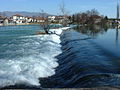 River Una near Bihać
 -
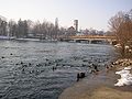 River Una near Bihać


Municipalities of the Una-Sana Canton | ||
|---|---|---|
