
Sardinia
This article needs additional citations for verification. (February 2009) |
Template:Infobox Region of Italy
This land does not resemble any other place. Sardinia is another thing: enchanting space around and distance to travel, nothing finished, nothing definitive. It's like freedom itself.
Sardinia (Template:PronEng; Italian: Sardegna; Sardinian: Sardigna or Sardinnya) is the second-largest island in the Mediterranean Sea (after Sicily). The area of Sardinia is 24,090 square kilometers (9,301 sq mi). The nearest land masses to the island are (clockwise from north) the French island of Corsica, the Italian Peninsula, Tunisia, and the Balearic Islands. Sardinia is part of Italy, with a special statute of regional autonomy under the Italian Constitution. The name is of unknown origin, though it may have to do with a tribe called the Sardi.
Geography

Sardinia is the second largest island in the Mediterranean Sea, with a surface of 23.821 km². It is situated between 38° 51' and 41° 15' latitude north and 8° 8' and 9° 50' east longitude.
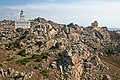
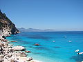
The coasts of Sardinia (1,849 km long) are generally high and rocky, rectilinear for kilometres, they are often articulated in promontories, with ample and deep bays and inlets surrounded by smaller isles.
The island, being an ancient territory with rocks that go back through the Palaeozoic Era (up to 500 million years old), does not possess any high mountains because of its long erosion processes. The granite, schist, tranchite, basalt (called "jars" or "gollei"), sandstone, and dolomite limestone (called tonneri or "heels") rocky highlands predominate at a height of between 300 and 1,000 meters. The entire territory of the island is non-seismic.
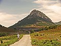
The Gennargentu is a large mountain massif in the center of the island; its highest peaks are Punta La Marmora (1,834 m.), Monte Limbara (1,362 m.) in the north, and Mount Rasu (1,259 m.), culminating in the Marghine chain, that runs crosswise for 40 km towards the north. The island's massifs and plateaus are separated by large alluvial valleys and flatlands; the main plains are the Campidano, located in the southwest between Oristano and Cagliari, and the Nurra, in the northwest.
Sardinia has few major rivers; the largest is the Tirso, which has a length of 94 miles (151 km) and flows into the Sardinian Sea. There are about fifty artificial lakes, of which Lake Omodeo and Lake Coghinas are the main ones. The only natural freshwater lake is Baratz Lake. A high number of large, salty lakes and lagoons are located along the 1.850 km of its coasts.
The climate is typical of the Mediterranean. The weather is clear. During the year approximately 300 days are sunny and the few others are rainy, with a major concentration of rainfall in the winter and autumn, some heavy showers in the spring, and snowfalls on the highest massifs and highlands. The mistral is the dominant wind, fresh, strong, and usually dry and cold, blowing from the northwest throughout the year, but most frequently in winter and spring.
-
 Sea in Stintino
 -
 Gorropu Canyon in Supramonte
 -
 Porto Giunco in Villasimius
 -
 Campidano's Plain near Las Plassas
 -
 Gennargentu Massif in winter
 -
-
 Cala Goloritzé
 -
 A typical limestone tacco in Ogliastra


.jpg)


History
Prehistory

Sardinia is one of the most ancient lands in Europe, visited during the Palaeolithic period though inhabited permanently by humans only much later, in the Neolithic age, around 6,000 B.C.[citation needed]
The first humans to settle in Gallura and northern Sardinia probably came from the Italian mainland and, in particular, from Etruria. Those who populated the central region of the island around the salt lakes of Cabras and S. Giusta may have arrived from the Iberian Peninsula by way of the Balearic Islands. Those who founded their settlements around the gulf of Cagliari were made up of several peoples.[citation needed]
Evidence of trade with other Aegean centres is present in the period 1600 BC onwards; for example fine ceramic products of Cydonia have been recovered in Sardinia.[1] As time passed, the Sardinian peoples became united in language and customs, yet remained divided politically into various smaller tribal states. Sometimes they banded together, while at others they were at war with one another. Tribes lived in villages made up of round thatched stone huts, similar to those of present-day shepherds.[citation needed]
From about 1500 B.C. onwards, the villages were built at the foot of truncated cone fortresses (often reinforced and enlarged with embattled towers) called nuraghi.
The boundaries of tribal territories were guarded by smaller lookout nuraghi erected on strategic hills commanding a view of the enemy. Today some 7,000 nuraghi dot the Sardinian landscape.
Ancient history

Around 1000 B.C. the Phoenicians began to land on the shores of Sardinia with increasing frequency. Setting sail from Lebanon, on their trade routes as far afield as Britain they needed safe anchorages for the night or to weather a storm.[citation needed] The more common ports of call were Caralis, Nora, Bithia, Sulcis, Tharros, Bosa and Olbia. They soon became important markets and after a time real towns, inhabited by Phoenician families who traded on the open sea and with the Nuragic Sardinians inland.[citation needed]
In 509 B.C., because the Phoenician expansion inland was becoming ever more menacing and penetrating, the native Sardinians attacked the coastal cities held by the enemy, who, in order to defend themselves, called upon Carthage for help. The Carthaginians, after a number of military campaigns, overcame the Sardinians and conquered the most mountainous region. For 271 years, the Carthaginian or Punic civilization flourished alongside the local culture.
In 238 B.C. the Carthaginians, defeated by the Romans in the first Punic War, surrendered Sardinia, which became a province of Rome. The Romans enlarged and embellished the coastal cities and founded new cities like Turris Lybissonis and Feronia , populated by roman immigrants , and with their armies even penetrated the central mountains,referred to by the Romans as Barbaria or Barbagia [citation needed], thereby bringing down the nuragic civilization. The Roman domination in Sardinia lasted 694 years and was often opposed by the Sardinians from the mountains who, nevertheless, adopted the Latin language and civilization.
Medieval history

In 456 A.D., when the Roman Empire was rapidly declining, the Vandals of Africa, on their return from a raid in Latium on the mainland Italy, occupied Caralis along with the other coastal cities of Sardinia. In 534 the Vandals were defeated in the Battle of Tricamarum by the troops of Justinian, and Sardinia thus became Byzantine. The island was divided into districts called merèie, governed by a judge residing in Caralis (Cagliari) and garrisoned by an army stationed in Forum Traiani (nowadays Fordongianus) under the command of a dux. With the Byzantines came Christianity, which spread throughout the island (along with the monasticism of the followers of St. Basil), except in the Barbagia region. Here, towards the end of the sixth century, a short-lived independent domain reestablished itself, with local heathen and religious traditions, one of its kings being Ospitone.[citation needed]
Raids and attacks by the Berbers on the Sardinian shores began in 710 and grew ever more ruinous with time. Their inhabitants abandoned the coastal towns and cities. The judge provincial, in order to afford a better defence of the island, assigned his civil and military powers to his four lieutenants in Cagliari, Torres or Logudoro, Arborea, and Gallura. Around 900, the lieutenants gained their independence, in turn becoming judices (Sardinian judike, 'king') of their own logo or state.
Each one of these four Sardinian states constituted a sovereign kingdom, not patrimonial but independent, since it was not the property of the monarch. But they were at the same time democratic, since all the most important issues of national interest were not for the king (or giudice) himself to decide but were a matter for the representatives of the people gathered in assembly called corona de logu. Each kingdom manned its own fortified boundaries to protect its own political and trading affairs, its own parliament, laws (cartas de logu), languages, chancelleries, state emblems and symbols, etc.[citation needed]
The kingdom or "giudicato" of Cagliari was politically pro-Genoese. It was brought to an end in 1258 when its capital, S. Igia, was stormed and destroyed by an alliance of Sardinian-Pisan forces. The territory then became a colony of Pisa.
The kingdom of Torres, too, was pro-Genoese and came to an end in 1259 on the death of the giudicessa Adelasia. The territory was divided up between the Doria family of Genoa and the Basserra family of Arborea, while the city of Sassari became an autonomous city-republic.
The kingdom of Gallura ended in the year 1288, when the last giudice, Nino Visconti (a friend of Dante Alighieri), was driven out by the Pisans who occupied the territory.
The kingdom of Arborea was almost always under the political and cultural influence of the powerful marine republic of Pisa. It lasted some 520 years, with Oristano as its capital.
In 1297, Pope Boniface VIII in order to settle diplomatically the War of the Vespers, which broke out in 1282 between the Angevins and Aragonese over the possession of Sicily, established on his own initiative (motu proprio) a hypothetical regnum Sardiniae et Corsicae ("kingdom of Sardinia and Corsica"). The Pope enfeoffed it to the Catalan James II of Aragon, king of Aragon (a confederation made up of the kingdoms of Aragon and Valencia, plus the County of Barcelona), promising him support should he wish to conquer Pisan Sardinia in exchange for Sicily.
In 1323 James II of Aragon formed an alliance with the kings of Arborea and, following a military campaign which lasted a year or so, occupied the Pisan territories of Cagliari and Gallura along with the city of Sassari, naming them "Kingdom of Sardinia and Corsica". In 1353, for reasons of state survival, war broke out between the kingdom of Arborea and the kingdom of "Sardinia and Corsica", part of the Crown of Aragon. In 1354 the Aragonese seized Alghero and reshaped it into an entirely Catalan city, which still today displays its Iberian origins.
In 1353 Peter IV of Aragon, called "the Cerimonious", granted legislative autonomy (a parliament) to the kingdom of "Sardinia and Corsica," which was followed in due course by self-government under a viceroy and judicial independence (Royal Hearing). From 1365 to 1409 the Arborean giudici Mariano IV, Ugone III, Mariano V (assisted by his mother Eleonora, the famous giudicessa regent), and Guglielmo III (French grandson of Eleonora) succeeded in occupying very nearly all Sardinia except Castle of Cagliari (today Cagliari and Alghero).
In 1409 Martin I, of Sicily ad heir to Aragon, defeated the Sardinians at the Battle of Sanluri and conquered once and for all the entire land. Shortly afterwards he died in Cagliari of malaria, without issue, and consequently the Crown of Aragon passed into the hands of the Castilians Trastàmara - in particular Ferdinand I of Aragon and his descendants - with the Compromise of Caspe in 1412.
Modern history
In 1479, as a result of the personal union of Ferdinand II of Aragon and Isabel of Castile, the Crown of Spain was born. Even the "kingdom of Sardinia" (which in the new title was separated from Corsica, since that island never was conquered) became Spanish, with the state symbol of the Four Moors. Following the failure of the military ventures against the Mulsumen of Tunis (1535) and Algiers (1541), Charles V of Spain, in order to defend his Mediterranean territories from pirate raids by the African Berbers, fortified the Sardinian shores with a system of coastal lookout towers.

The kingdom of Sardinia remained Spanish for approximately 400 years, from 1323 to 1720, assimilating a number of Spanish traditions, customs, and linguistic expressions, nowadays vividly portrayed in the folklore parades of Saint Efisio in Cagliari (May 1), the Cavalcade on Sassari (last but one Sunday in May), and the Redeemer in Nuoro (August 28).
In 1708, as a consequence of the Spanish War of Succession, the rule of the kingdom of Sardinia passed into the hands of the Austrians who landed on the island. In 1717 Cardinal Giulio Alberoni, minister of Felipe V of Spain, reoccupied Sardinia. In 1718, with the Treaty of London, Sardinia was handed over to the House of Savoy.
On 28 April 1794, during an uprising in Cagliari, two Piedmontese officials were killed. That was the start of a revolt (called the Moti rivoluzionari sardi) all over the island, which culminated in the expulsion of the tyrants. On 28 December 1795 in Sassari insurgents demonstrating against feudalism, mainly from the region of Logudoro, occupied the city. On 13 February 1796, in order to suppress a riot, the viceroy Filippo Vivalda gave to the Sardinian magistrate Giovanni Maria Angioy the role of Alternos, which meant a substitute of the viceroy himself. Angioy moved from Cagliari to Sassari, and during his journey almost all the villages joined the uprising, asking for the end of feudalism and for the independence of Sardinia's people.
In 1799, as a consequence of the Napoleonic wars in Italy, the Dukes of Savoy left Turin and took refuge in Cagliari for some fifteen years. In 1847 the Sardinians spontaneously renounced their state autonomy ad formed a union with Piedmont in order to have a single parliament, a single magistracy, and a single government in Turin.
In 1848 the Italian Wars of Independence broke out for the Unification of Italy and were led by the kings of Sardinia for thirteen years. In 1861 Sardinia joined the newly founded Kingdom of Italy.
During the First World War the Sardinian soldiers of the Brigata Sassari distinguished themselves, several being decorated with gold medals and other honors. It was the first and only Italian military unit constituted exclusively from Sardinian soldiers.
The Sardinian writer Grazia Deledda won Nobel Prize for Literature in 1926.
During the fascist period, and implementation of the policy of autarky, several swamps were reclaimed around the island and agrarian communities founded. The main communities were in the area of Oristano, where the village of Mussolinia (now called Arborea) was located, and in the area adjacent the city of Alghero, within the region of Nurra, Fertilia was founded. Also established during that time was the city of Carbonia, which became the main center of mining activity. Works to dry the numerous waste lands and the reprise of mining activities favored the arrival of settlers and immigrants, at first from Veneto, and after World War II Istrians and Dalmatians from Yugoslavia.
The repression by the fascist regime of its opponents within the region was ruthless. Antonio Gramsci, one of the founders of the Italian Communist Party, was arrested and died in prison. Michele Schirru was executed after a failed assassination plot against Benito Mussolini.
Postwar period
In 1946 by popular referendum Italy became a republic, with Sardinia administered since 1948 by special statute of autonomy.
By 1951, malaria was successfully eliminated with the support of the Rockefeller Foundation, which facilitated the commencement of the Sardinian tourist boom, mainly focused on beach holidays and elite tourism. Today about ten million people visit the island every year.
With the increase in tourism, coal decreased in importance. In the 1950s and 1960s the greatest Sardinian migration began. However, in the early 1960s an industrialization effort was commenced, the so-called Piani di Rinascita (rebirth plans), with the initiation of major infrastructure projects on the island. These included the construction of new dams and roads, reforestation, agricultural zones on reclaimed marshland, and large industrial complexes (primarily oil refineries and related petrochemical operations). With the creation of petrochemical industries, thousands of ex-farmers became industrial workers. Nevertheless, following 1973 the international oil crisis caused the termination of employment for thousands of workers employed in the petrochemical industries.
The economic crisis, unemployment, and the forced militarization of the island territory (70% of Italian military bases were located in Sardinia) aggravated the crime rate, with increasing kidnappings and political subversion. Communist groups flourished, the most famous being Barbagia Rossa, which perpetrated several terrorist actions between the 1970s and the early 1980s.
In 1983 a militant of an autonomist party, the Sardinian Action Party (Partito Sardo d'Azione), was elected president of the regional parliament, and in the 1980s several independentist movements were born; in the 1990s some of them became political parties, and in 2006 in the Province of Sassari the first independentist militant was elected. In 1999 Sardinian received official status together with Italian.
Today Sardinia is phasing in as an EU region, with a diversified economy focused on tourism and the tertiary sector; the economic efforts of last twenty years have reduced the handicap of insularity, for example with low-cost air companies and advanced information technology, thanks to the CRS4 (Center for Advanced Studies, Research and Development in Sardinia), which developed the first Italian website in 1991 and webmail in 1995, which brought to birth several telecommunication companies and internet service providers based on the island, as Videonline in 1994 and Tiscali in 1998.
The next G8 summit was planned to be held in Sardinia, on the island of La Maddalena, in July 2009. The Italian Prime Minister, Silvio Berlusconi, in April 2009, violating the autonomous status of Sardinia, decided, without convoking the Italian parliament or consulting the governor of Sardinia, to move the summit, even though the works were almost completed, to L'Aquila, provoking protests among Sardinians.
Economy

Taken as a whole, Sardinia's economic conditions are such that the island is in a slightly better position than the average southern regions. The greatest economic development has taken place inland, in the provinces of Cagliari and Sassari, characterized by a certain amount of enterprise. According to Eurostat, the 2007 GDP was €33,823.2 million, resulting in a €20,444.1 GDP per capita.
The primary sector is still of outstanding importance, especially goat and sheep rearing (good production of cheese). Agriculture has been modernized on the Campidano plain (vegetables, citrus, rice), and Sardinian wines are famous. There is little fishing (and no real maritime tradition), but the once prosperous mining industry is still active though restricted to coal (Carbonia, Bacu Abis), antimony (Villasalto), gold (Furtei), and lead and zinc (Iglesiente, Nurra). The granite extraction represents one of the most flourishing industry in the northern island. The Gallura granite district is composed of 260 companies that work in 60 quarries, where 75% of the Italian granite is extracted. The cork district, in the northern part of the Gallura region, around Calangianus and Tempio Pausania, is composed of 130 companies and has become the driver of Sardinian economic development. Every year in Sardinia 200,000 quintals of cork are carved, and 40% of the end products are exported. Fishing along the coasts is also an important activity on the island. Portoscuso tunas are exported worldwide, but primarily to Japan.
The principal industries are chemicals (Porto Torres, Cagliari, Villacidro, Ottana), petrochemicals (Porto Torres, Sarroch), metalworking (Porto Scuso, Porto Vesme, Villacidro), cement (Cagliari), pharmaceutical (Sassari), shipbuilding (Arbatax, Olbia, Porto Torres), oil rig construction (Arbatax), and food (sugar refineries at Villasor and Oristano, dairy at Arborea, Macomer and Thiesi, fish factory at Olbia). Craft industries include rugs (Barbagia), lacework (Bosa), basket making, and coral.
The Sardinian economy is today focused on the overdeveloped tertiary sector (67.8% of employment), with commerce, services, information technology, and especially on tourism, which represents the main industry of the island with 2,721 active companies and 189,239 rooms. In 2008 there were 2,363,496 arrivals (up 1.4% on 2007). In the same year, the airports of the island registered 11,896,674 passengers (up 1.24% on 2007)[2].
Transportation

Sardinia has three international airports (Alghero Airport, Olbia - Costa Smeralda Airport, and Cagliari-Elmas Airport) connected with the principal Italian cities and many European destinations, mainly in the United Kingdom, Scandinavia, Spain, and Germany, and two regional airports (Oristano-Fenosu Airport and Tortolì Airport). Sardinian citizens benefit from special sales on plane tickets, and several low-cost air companies operate on the island. Meridiana is an airline based in the airport of Olbia; it was founded as Alisarda in 1963 by the Aga Khan, Prince Karim al-Hussayni.
The ferry companies operating on the island are Tirrenia, Moby Lines, Corsica Ferries, Grandi Navi Veloci, Snav, Sncm, and CMN; they link the Sardinian harbors of Porto Torres, Olbia Isola Bianca, Golfo Aranci, Arbatax, Santa Teresa Gallura, Palau and Cagliari with Civitavecchia, Genoa, Livorno, Naples, Palermo, Fiumicino, Trapani, Piombino in Italy, Marseille, Toulon, Bonifacio, Propriano, Ajaccio, and Bastia in France, and Barcelona, in Spain. A regional ferry company, the Saremar, links the main island to the islands of La Maddalena and San Pietro.


Sardinia is the only Italian region without motorways, but the road network is well developed, with a system of "superstrade" (dual carriage freeways), that connect the principal towns and the transport infrastructures; the speed limit is 90 km/h. The principal road is the SS131 "Carlo Felice", linking the north with the south of the island, crossing the most populated regions of Sassari and Cagliari; it is part of European route E25. The SS 131 d.c.n links Oristano with Olbia, crossing the hinterland Nuoro region. Other roads designed for high-capacity traffic link Sassari with Alghero, Sassari with Tempio Pausania, Sassari - Olbia, Cagliari - Tortolì, Cagliari - Iglesias, Nuoro - Villagrande Strisaili. A work in progress is converting the main routes to highways standards, with the elimination of all intersections. The secondary inland and mountain roads are generally narrow with many hairpin turns, so the speed limits are very low.
Public transport buses reach every town and village at least once a day; however, due to the low density of population, the smallest territories are reachable only by car. The Azienda Regionale Sarda Trasporti (Arst) is the public regional bus transport agency.
The Sardinian railway system was developed in the 19th century, by the English engineer Lord Benjamin Piercy. Trains connect the whole island, and there are two different railway operators. Trenitalia is the largest, connecting the largest towns, the main ports, and also the Italian peninsula through the use of train ferries. This network is the most modern on the island, running primarily diesel locomotives such as the Alstom "Minuetto" and, in the future, high-speed trains such as the Talgo XXI. The second operator is ARST Gestione FdS, best known as Ferrovie della Sardegna (Sardinian Railways), running on narrow-gauge track, and they are generally very slow, except the electrified Tram-trains, operating in the metropolitan areas of Sassari and Cagliari. Many tourists catch the trenino verde, which runs through the wildest parts of the island. It is slow but allows the traveller to have scenic views impossible to see from the main road. The train connects Cagliari to Arbatax in the south and Sassari to Palau in the north.
Demographics
| Year | Pop. | ±% |
|---|---|---|
| 1861 | 609,000 | — |
| 1871 | 636,000 | +4.4% |
| 1881 | 680,000 | +6.9% |
| 1901 | 796,000 | +17.1% |
| 1911 | 868,000 | +9.0% |
| 1921 | 885,000 | +2.0% |
| 1931 | 984,000 | +11.2% |
| 1936 | 1,034,000 | +5.1% |
| 1951 | 1,276,000 | +23.4% |
| 1961 | 1,419,000 | +11.2% |
| 1971 | 1,474,000 | +3.9% |
| 1981 | 1,594,000 | +8.1% |
| 1991 | 1,648,000 | +3.4% |
| 2001 | 1,632,000 | −1.0% |
| 2008 (Est.) | 1,670,000 | +2.3% |
| Source: ISTAT 2001 | ||
With a population density of 69 pop./km2, slightly more than a third of the national average, Sardinia is the fourth least populated region in Italy. The population distribution is anomalous compared to that of other Italian regions lying on the sea. In fact, contrary to the general trend, urban settlement has not taken place primarily along the coast but towards the centre of the island. Historical reasons for this include repeated Saracen raids during the Middle Ages (making the coast unsafe), widespread pastoral activities inland, and the swampy nature of the coastal plains (reclaimed only in the 20th century). The situation has reversed with the expansion of seaside tourism; today all Sardinia's major urban centres are located near the coasts, while the island's interior is very sparsely populated.
It is the Italian region with the lowest total fertility rate[3] (1.087 births per woman), and the region with the second lowest birth rate[4]; these factors, together with the high level of urbanization of population, allow the preservation of the greater part of the natural environment.
Average life expectancy is 81.1 years (84.5 for women and 77.7 for men). Sardinia shares with the Japanese island of Okinawa the highest rate of centenarians in the world (22 centenarians/100,000 inhabitants).


Government and politics
Administrative divisions
Until 2005, Sardinia had been divided into four provinces: Cagliari, Nuoro, Oristano and Sassari. In 2005 the Regional Council decided to create four new provinces becoming operative with the provincial elections for the Presidents and the Councils held in 2006. The four additional provinces are as follows: Carbonia-Iglesias, Medio Campidano, Ogliastra, Olbia-Tempio.

| Province | Area (km²) | Population | Density (inh./km²) |
|---|---|---|---|
| Province of Cagliari | 4,570 | 559,416 | 122.4 |
| Province of Carbonia-Iglesias | 1,495 | 130,538 | 87.3 |
| Province of Medio Campidano | 1,516 | 103,107 | 68.0 |
| Province of Nuoro | 3,934 | 161,453 | 41.0 |
| Province of Ogliastra | 1,854 | 58,088 | 31.3 |
| Province of Olbia-Tempio | 3,399 | 153,886 | 45.2 |
| Province of Oristano | 3,040 | 167,357 | 55.0 |
| Province of Sassari | 4,282 | 336,374 | 78.5 |
Culture

Sardinia is one of two Italian regions whose inhabitants have been recognised as a popolo (a distinct people) by a local statute (which is adopted with a constitutional law). (The other region is Veneto, but this was not through a constitutional law).
Music
Sardinia is home to one of the oldest forms of vocal polyphony, generally known as cantu a tenore; several famous musicians have found it irresistible, including Frank Zappa, Ornette Coleman, and Peter Gabriel. The last travelled to the town of Bitti in the central mountainous region and recorded the now world-famous Tenores di Bitti CD on his Real World label. The guttural sounds produced in this form make a remarkable sound, similar to Tuvan throat singing. Another polyphonic style of singing, more like the Corsican paghjella and liturgic in nature, is found in Sardinia and is known as cantu a cuncordu.
Another unique instrument is the launeddas. Three reed-canes (two of them glued together with beeswax) producing distinctive harmonies, which have their roots many thousands of years ago, as demonstrated by the bronzette from Ittiri, of a man playing the three reed canes, dated to 2000 BC.
Beyond this, the tradition of cantu a chiterra (guitar songs) has its origins in town squares, when artists would compete against one another. The most famous singer of this genre are Maria Carta and Elena Ledda.
Sardinian culture is alive and well, and young people are actively involved in their own music and dancing. In 2004, legendary BBC presenter Andy Kershaw travelled to the island with Sardinian music specialist Pablo Farba and interviewed many artists. His programme can be heard on BBC Radio 3. Sardinia has produced a number of notable jazz musicians as Antonello Salis, Marcello Melis, and Paolo Fresu.
The main opera house of the island is the Teatro Lirico in Cagliari.
Language


The most spoken language in Sardinia is Italian, but Sardinian is widely spoken all over the island. Sardinian is a Romance language of Latin origin, influenced by Catalan and Spanish, but with indigenous elements, with some roots from Phoenician, Etruscan, and other Near Eastern languages.[citation needed] While it has been significantly supplanted by Italian for official purposes, in 2006 the regional administration has approved the use of Limba Sarda Comuna[5] in official documents. As a literary language, it is gaining clout, despite heated debate about the lack of standard orthography and controversial proposed solutions to this problem.
The two most widely spoken forms of the Sardinian languages are Campidanese, from the flatlands (Campidano) that cover most of the south (from Cagliari to Oristano), and Logudorese (Logudoro), from the central region, extending almost to Sassari.
Genetic peculiarities
The original inhabitants of Sardinia, who are now concentrated in the interior of the island due to pressure from colonists, are a genetic anomaly [citation needed] in the western Mediterranean region. They belong to Y-chromosome haplogroup I, which otherwise has high frequency only in Scandinavia, Denmark, Northern Germany and the Croatia-Bosnia area.
Furthermore, the I haplogroup of the indigenous Sardinians is of the I1b1b subtype, which is almost unique to the island. The I1b1b haplogroup also has a low distribution in and around the Pyrenees indicating some migration of Sardinians to or from that area. The Sardinian subtype is more closely related to the Croatian-Bosnian subtype than to the Scandinavian subtype. Sardinia also has a relatively high distribution of Y-chromosome haplogroup G, stemming from people that migrated to Sardinia from Anatolia [citation needed]. The Y-chromosome haplogroup G also has a relatively high concentration in and around the Pyrenees, again indicating migration of Sardinians to or from that area.[citation needed]
Sport
Cagliari is home to Cagliari Calcio F.C., which was founded in 1920 and plays in the Serie A, the Italian top division. It won the Italian Championship after the 1969/70 season, becoming the first club in Southern Italy to achieve such a result. Home matches are played at the Stadio Sant' Elia, named after the area where it is located, with a capacity of 23,486. It was built in 1970 and refurbished before the Italia '90 football World Championships.
Sardinia also boasts a fine darts tradition, which many believe originated in the Sassari region of the country towards the end of the 15th century. In those days, the darts were carved from Beech (Fagus) wood and the flights were feathers drawn from the indigenous pollo sultano, a bird famed for its spectacular violet-blue plumage.
Cagliari hosted a Formula 3000 race in 2002 and 2003 on a 2.414-km street circuit around Sant'Elia stadium. In 2003, Renault F1's Jarno Trulli and former Ferrari's Jean Alesi did a spectacular exhibition. At the Grand Prix BMW-F1 driver Robert Kubica took part in a F.3 car, as did BMW WTCC Augusto Farfus, GP2's Fairuz Fauzy and Vitaly Petrov. Since 2004 Olbia has hosted the Rally d'Italia Sardegna, a rally competition in the FIA World Rally Championship schedule. The rally is held on narrow, twisty, sandy and bumpy mountainous roads around the glamorous town of Porto Cervo.
Porto Pollo, north of Palau, is a bay often used by windsurfers and kitesurfers. The bay is divided by a thin tongue of land that separates it in an area for advanced and beginning/intermediate windsurfers. There is also a restricted area for kitesurfers. Many Italian freestyle surfers come to Porto Pollo for training and 2007 saw the finale of the freestyle pro kids Europe 2007 contest. Because of a venturi-effect between Sardinia and Corsica, western wind accelerates between the islands and creates the wind that makes Porto Pollo popular amongst windsurfing enthusiasts. In 2005, Aglientu, hosted the Kitesurf World Cup in the Vignola's beach.
Sa strumpa, also known as Sardinian Wrestling, is a traditional Sardinian sport, officially recognized by the Italian National Olympic Committee (C.O.N.I.) and International Federation of Celtic Wrestling (I.F.C.W.).
World Heritage Sites
Megalithic building structures called nuraghe are scattered in great number throughout Sardinia. Su Nuraxi di Barumini is a UNESCO World Heritage Site.[6]
Environment

Sardinia is home to a wide variety of rare or uncommon animals and autochthonous plants and animals, such as many species of mammals: the Mediterranean Monk Seal, the Giara's Pony, the white donkey, the Mouflon, the sardinian deer, the sardinian fox, and the boar. Found only in Sardinia, Sicily, and the Maghreb, the Sardinian skink (Chalcides ocellatus), known more commonly as the tiligugu, can reach 30 cm (12 in) in length, of which almost half consists of the tail. Conversely, Sardinia lacks many common species such as the viper and the marmot, which are found everywhere else on the European continent. The island has also long been used for grazing flocks of indigenous Sardinian sheep. Sardinia has four endemic subspecies of birds found nowhere else in the world: its Great Spotted Woodpecker (ssp harterti), Great Tit (ssp ecki), Chaffinch (ssp sarda), and Eurasian Jay (ssp ichnusae). It also shares a further 10 endemic subspecies of bird with Corsica.
The island's environment is improving due to strict environmental laws, and after an enormous plan of reforestation has become the Italian region with the largest forest extension, with 1,213,250 hectares of woods. The Regional Landscape Plan prohibits new building activities on the coast (except in urban centers), next to forests, lakes or other environmental or cultural sites.
Renewable energies have increased noticeably in recent years, mainly wind power, favoured by the windy climate, but also solar power (Carlo Rubbia, Nobelist in physics, is creating an experimental solar thermal energy central) and biofuel, based on Jatropha oil.
Today Sardinia is the Italian region that absorbs the highest percentage of greenhouse gases per inhabitant.
Natural parks and reserves

Sardinia has three national parks:
Ten regional parks:
- Parco naturale regionale di Porto Conte
- Parco regionale Molentargius - Saline
- Parco del Limbara
- Parco del Marghine e Goceano
- Parco del Sinis - Montiferru
- Parco del Monte Arci
- Parco della Giara di Gesturi
- Parco del Monte Linas - Oridda - Marganai
- Parco dei Sette Fratelli - Monte Genas
- Parco del Sulcis
There are 60 wildlife reserves, 5 W.W.F oases, and 25 natural monuments.
See also
- Sardinian language: Gallurese, Sassarese
- History of Sardinia
- Tourist destinations of Sardinia
- List of Sardinians
- List of rulers of Sardinia
- Sardinian archaeological and artistic sites
- Tavolara Island, an island off Olbia, Sardinia, which is a self-proclaimed micronation
- Basilica di Saccargia
Notes
- ^ C. Michael Hogan. 2008
- ^ "Il turismo in Sardegna è cresciuto anche nel 2008 - Regione Autonoma della Sardegna". Regione.sardegna.it. Retrieved 2009-05-06.
- ^ ISTAT Numero medio di figli per donna per regione 2002-2005
- ^ ISTAT Tassi generici di natalità, mortalità e nuzialità per regione 2002-2005
- ^ http://www.regione.sardegna.it/documenti/1_72_20060418160308.pdf
- ^ UNESCO, 2008
References
- C. Michael Hogan, Jan. 23, 2008, Cydonia, Modern Antiquarian, [1]
- UNESCO World Heritage Site inscription data for Su Nuraxi di Barumini (2008) [2]
External links
 Definitions from Wiktionary
 Media from Commons
 News from Wikinews
 Quotations from Wikiquote
 Texts from Wikisource
 Textbooks from Wikibooks
 Resources from Wikiversity

_sun_rise_at_Santa_Stefano_Italy.jpg)