
Karaman Province
This article needs additional citations for verification. (May 2011) |
Template:Infobox Province TR Karaman Province (Turkish: Karaman ili) is a province of south-central Turkey. It has an area of 9,163 km². It has a population of 232,633 (2010 est). According to the 2000 census the population was 243,210. Population density is 27.54 people/km². The traffic code is 70. The capital is the city of Karaman. Karaman was the location of the Karamanid emirate, which came to an end in 1486.
Districts
Karaman province is divided into 6 districts (capital district in bold):
Towns
Place of interest
- Binbirkilise, a region around Karadağ Mountain 30 km (19 mi) north of Karaman with Byzantine church ruins
See also
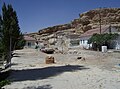
- Görmeli, a village on the hillside of the Taurus Mountains near Ermenek
- Karadağ Mountain, an extinct volcano north of Karaman city
- List of populated places in Karaman Province
Gallery
-
 Görmeli, a village in Ermenek district
 -
 Akpınar village in Ayrancı district
 -
 View of Ala Bridge near Ermenek


References
External links
Wikimedia Commons has media related to Karaman Province.
- Template:Tr icon Karaman governor's official website
- Template:Tr icon Karaman municipality's official website
- Template:En icon Karaman weather forecast information
37°01′23″N 33°05′39″E / 37.02306°N 33.09417°E
See also


This geographical article about a location in Karaman Province, Turkey is a stub. You can help Wikipedia by expanding it. |