
MAX Light Rail
| MAX Light Rail | |
|---|---|
 | |
 Top: A MAX train and a Portland Streetcar tram traversing Tilikum Crossing Bottom: A westbound Type 2 Blue Line train crossing the Steel Bridge | |
| Overview | |
| Owner | TriMet |
| Area served | Clackamas, Multnomah, and Washington counties |
| Locale | Portland, Oregon, U.S. |
| Transit type | Light rail |
| Number of lines | 5 |
| Number of stations | 94 (1 temporarily closed)[1] |
| Daily ridership | 120,900 (as of 2019[update])[2] |
| Annual ridership | 38,817,600 (as of 2019[update])[2] |
| Website | MAX Light Rail |
| Operation | |
| Began operation | September 5, 1986 |
| Operator(s) | TriMet |
| Number of vehicles | 145[3] |
| Technical | |
| System length | 59.7 mi (96.1 km) |
| Track gauge | 4 ft 8+1⁄2 in (1,435 mm) standard gauge |
| Electrification | 750 V DC, overhead catenary[4] |
MAX Light Rail (for Metropolitan Area Express) is a light rail system in Portland, Oregon, United States, that is owned and operated by TriMet. It consists of 94 stations over a 59.7-mile (96.1 km) network and is served by five lines, each of which is designated by a color. The system connects the north, northeast, and southeast sections of Portland; the suburban communities of Beaverton, Clackamas, Gresham, Hillsboro, and Milwaukie; and Portland International Airport to Portland City Center. MAX is the fourth-busiest light rail system in the United States after comparable light rail services in Los Angeles, Boston, and San Francisco. The system had an average daily ridership of 120,900 and nearly 39 million annual riders in 2019. Lines run seven days a week with headways of between 30 minutes off-peak and five minutes during rush hours.
MAX was among the first second-generation American light rail systems to be built. It was conceived as a result of freeway revolts that took place in Portland in the early 1970s. Construction of the network's inaugural eastside segment, which was then known as the Banfield light rail project, began in 1982 following a study of mass transit alternatives using funds diverted from the canceled Mount Hood Freeway and Interstate 505 (I-505). This line commenced service between 11th Avenue in downtown Portland and Cleveland Avenue in Gresham on September 5, 1986.
Building upon the original line, MAX was extended west to downtown Hillsboro in 1998, northeast to Portland Airport in 2001, north to the Expo Center in 2004, across the Portland Transit Mall in August 2009, and south to Clackamas Town Center in September 2009. The Orange Line's Portland–Milwaukie segment, which opened in 2015 and terminates just south of Milwaukie, is the system's latest extension. Future expansion plans include extending Red Line service further west to Fair Complex/Hillsboro Airport station in 2023 and if voters approve funding in November 2020, a planned rail extension through Southwest Portland and Tigard to Tualatin that is know as the Southwest Corridor light rail project, is scheduled to open in 2027.
MAX is one of three urban rail transit services operating in the Portland metropolitan area, the other two being the Portland Streetcar and WES Commuter Rail. MAX provides direct connections to additional modes of public transportation, including local and intercity buses at most stations and Amtrak via Portland Union Station. MAX trains operate at a maximum of two-car consists, owing to downtown Portland's short city blocks. Fares are charged at a flat rate and are mainly collected through the Hop Fastpass payment system.
History
Background
_(247).jpg)
In the early 20th century, privately funded interurban railways gave Portland one of the largest urban rail systems in the American West, including lines that once extended from Forest Grove to Troutdale and Vancouver, Washington to Eugene.[5]: 7–8 [6] Ben Holladay brought over Portland's first trolleys from San Francisco; they were introduced in 1872 and were initially drawn by horses and mules. In 1890, the first electric streetcar service opened in Albina, which was operated by the Willamette Bridge Railway Company, and the first cable car began running along 5th Avenue in Portland; these lines marked the start of an era of major streetcar line expansion.[7]
The East Side Railway Company built the city's first long-distance interurban line in 1892, a 16-mile (25.7 km) route between Portland and Oregon City.[8] The Portland Railway, Light and Power Company took over all local streetcars by 1906,[9] and interurban operations by 1908.[10]: 93 In 1912, as Portland's population exceeded 250,000, transit ridership rose to 70 million passengers annually.[5]: 8 Streetcars started to decline by the 1920s in line with the rise of the automobile and suburban and freeway development.[5]: 9 The region's last two interurban lines, which went to Oregon City and Bellrose (Southeast 136th Avenue), ceased operation in 1958.[10]: 61, 93 [5]: 10
Early beginnings
.jpg)
At the height of local freeway revolts in the 1970s, TriMet began a study for mass transit using funds made available by the passage of the Federal-Aid Highway Act of 1973.[5]: 20 These funds had been intended for the Mount Hood Freeway and I-505 projects,[5]: 30 which were abandoned amid strong opposition from the city government and neighborhood associations.[11][12] In 1973, Governor Tom McCall assembled a separate task force that helped determine several options, including a busway and light rail.[13]
The Highway Division had originally favored the busway option[14] but support for light rail prevailed following the mode's inclusion in a 1977 environmental impact statement.[15] The proposal became known as the Banfield light rail project, which was named for the Banfield Freeway, a segment of I-84 that part of the alignment followed. TriMet formally approved the project in September 1978.[16] Construction of the initial 15.3-mile (24.6 km), 27-station route between 11th Avenue in downtown Portland and Cleveland Avenue in Gresham commenced in March 1982.[17] It opened on September 5, 1986.[18] Less than two months before opening, TriMet adopted the name Metropolitan Area Express or MAX for the new line following an employee contest.[19]

As the planning of a light rail line to the west side gained momentum in the mid-1980s, the original MAX line came to be referred to as the Eastside MAX to distinguish it from what would become the Westside MAX extension.[20] Early proposals called for this extension to terminate near 185th Avenue, just west of the Beaverton–Hillsboro city boundary.[21] A dispute over a financing plan suspended the project for several years but planning resumed in 1988 and studies were completed in 1991.[22][21]
Staunch lobbying by local and state officials led by Hillsboro Mayor Shirley Huffman forced an extension of the line further west to downtown Hillsboro in 1993.[23] Construction of the 20-station, 18-mile (29 km) line began that August with the excavation of the Robertson Tunnel.[24] The extension opened in two stages following delays in construction: the section from 11th Avenue to Kings Hill/Southwest Salmon Street was opened in 1997 and the section to Hatfield Government Center—the segment's current western terminus—was opened in 1998.[25] The resulting 33-mile (53 km) MAX line began operating as a single, through service on September 12, 1998.[26] This service was renamed the Blue Line in 2001 after TriMet adopted color designations for its light rail routes.[27]
South–North proposal
In the mid-1980s, Metro regional government announced plans to extend light rail to Clackamas County. Officials proposed two routes; one between downtown Portland and Oregon City via Milwaukie and another between Portland International Airport and Clackamas Town Center via I-205.[28] Planning progressed in greater favor of the I-205 corridor due to an existing right-of-way along the I-205 Transitway, an unfinished mass transit component of the freeway that had been intended as a busway.[29][30] TriMet, however, prioritized the Westside MAX during its bid for federal matching funds and the I-205 plans were put on hold.[31]
In 1989, studies for the I-205 and Milwaukie proposals received funding from the U.S. Senate Committee on Appropriations with a requirement to include route extensions to Clark County, Washington.[32][33] Metro completed the studies in 1993, abandoning I-205 in favor of a route along the I-5 and Willamette River corridors.[34][35] It finalized a single 25-mile (40 km) line from Hazel Dell, Washington south to Clackamas Town Center via Milwaukie.[36][37] TriMet formally named this the South–North Line.[5]: 80
Portland area voters passed a $475 million ballot measure to fund Oregon's portion of the South–North Line project in November 1994.[5]: 80 In February 1995, however, Clark County residents defeated a tax measure that would have funded Washington's share.[38] In an effort to move forward with the project, TriMet downsized the plan, abandoning the line's Clark County and North Portland segments up to the Rose Quarter.[39] The following July, the Oregon House of Representatives approved a $750 million transportation package that included $375 million for the scaled-back line.[40] This was nullified by the Oregon Supreme Court due to the inclusion of unrelated measures,[41] which violated the state's constitution.[42]
The legislature met again in February 1996 to pass a revised $375 million package,[41] which light rail opponents defeated in a statewide vote the following November.[43] A third proposal placing the line between Lombard Street in North Portland and Clackamas Town Center followed.[44] Metro and TriMet pursued this project without seeking contributions from either Clark County or the state, instead sourcing funds from Clackamas County and Portland. In 1998, TriMet placed a new ballot measure to reaffirm voter support for the originally-approved $475 million.[5]: 80 The measure failed by 52% in November of that year, effectively canceling the proposed line.[45]
Airport and Interstate lines
.jpg)
Compelled by the rapid expansion of Portland International Airport in the 1990s, the Port of Portland began exploring ways to alleviate worsening congestion,[46] including the possibility of introducing MAX service,[47] which regional planners had not anticipated for at least another 20 years.[48] In 1997, engineering firm Bechtel accelerated plans and submitted an unsolicited proposal to design and build this light rail extension.[47][49] A public–private partnership between the company and local governments was negotiated and construction of the Airport MAX project began in June 1999.[5]: 82 [50]
With no federal assistance requested and right-of-way already secured,[5]: 82 construction progressed rapidly.[51] The four-station, 5.5-mile (8.9 km) extension between Gateway/Northeast 99th Avenue Transit Center and Portland International Airport station opened for Red Line service on September 10, 2001.[52][53] Celebrations scheduled for that weekend were canceled in the aftermath of the September 11 attacks.[54] The Red Line originally ran between the airport and downtown, turning around at the loop tracks on 11th Avenue.[55] On September 1, 2003, it was extended west along existing tracks to Beaverton Transit Center to relieve overcrowding on the Blue Line and to create a one-seat airport connection for the west side.[56]

In 1999, Portland business leaders and residents who were opposed to the cancellation of the South–North Line argued that despite the project's defeat in regional polls, Multnomah County voters supported it.[57][58] In response, TriMet developed a new proposal that would expand light rail service solely to North Portland, from the Rose Quarter to the Portland Expo Center via North Interstate Avenue, a part of Oregon Route 99W (OR 99W).[59] TriMet moved forward with this plan, known as the Interstate MAX project, and broke ground in February 2001.[60]
To minimize costs, the city created an urban renewal district,[61] and federal matching funds were allocated from the Airport MAX and Portland Streetcar projects, since these were locally funded.[62] The 10-station, 5.8-mile (9.3 km) Interstate MAX opened on May 1, 2004 with its new service designated the Yellow Line.[63] From 2004 to 2009, the Yellow Line ran from Expo Center station in North Portland to 11th Avenue in downtown Portland, following the Blue and Red lines' downtown alignment from the Steel Bridge. On August 30, 2009, it was rerouted to terminate at the PSU Urban Center stations with the addition of light rail to the Portland Transit Mall.[64] In September 2012, this was extended further south to the PSU South stations, which had not been built due to the construction of nearby transit-oriented development.[65][66] The Yellow Line became interlined with the Orange Line in 2015; it now only operates the northbound segment of the transit mall.[67]
South Corridor extensions
In 2001, Metro planners discussed a potential revival of plans to extend light rail services to Clackamas County. They considered two possible routes extending from downtown Portland to the eastside communities of Clackamas and Milwaukie. Both proposals were similar to those of the canceled South–North Line project.[68] This resulted in a new study, which was referred to as the South Corridor transportation project,[69] that evaluated light rail and several alternative modes.[70] The study's task force recommend both light rail options and also suggested splitting the project into two phases.[71][72]
The first phase planned to add light rail to I-205, between Gateway Transit Center and Clackamas Town Center. In October 2003, the first phase plans were amended to include light rail service to the Portland Transit Mall following a petition from Portland business leaders.[73] The combined project was approved for federal funding in 2006[74] and work began in January 2007 with the reconstruction of the transit mall.[75] Light rail commenced service along the 14-station, 1.8-mile (2.9 km) Portland Transit Mall on August 30, 2009, inaugurating the Yellow Line.[64] The opening of the eight-station, 6.5-mile (10.5 km) I-205 extension and Green Line service followed on September 12.[76]

The second phase of the South Corridor project initially comprised the extension of MAX between downtown Portland and Milwaukie via the Hawthorne Bridge.[77] This phase proposed using the existing downtown alignment along Southwest Morrison and Yamhill streets, which was already being used by the Blue, Red, and Yellow lines.[73] Studies showed this, in addition to running light rail along the Hawthorne Bridge, would cause severe traffic bottlenecks in downtown. As a result, Portland businesses pushed for the construction of a new bridge that led to the southern end of the Portland Transit Mall.[70] The locally preferred alignment was finalized in mid-2008; a new bridge would convey light rail from South Waterfront on the west end to just south of the Oregon Museum of Science and Industry (OMSI) on the east end.[78] TriMet designed this bridge, which was eventually inaugurated as Tilikum Crossing, to be "car-free" and to accommodate only transit vehicles, trains, bicycles, and pedestrians.[79]
Construction of the line began in June 2011;[80] as work progressed, it faced strong opposition by opponents of the so-called "Portland Creep", a perceived encroachment of Portland townscape on neighboring communities.[81] In September 2012, opponents passed a ballot initiative—with 60% of the vote—requiring all Clackamas County spending on light rail to be approved by voters.[82] Following the county's attempt to end its involvement and a suit filed by TriMet, a circuit court upheld the project's continuation.[83]: 95–96 The 17-station, 7.3-mile (11.7 km) Portland–Milwaukie segment and Orange Line service opened on September 12, 2015.[84] The Orange Line, operating along the corridor's southbound segment, became the third service to serve the Portland Transit Mall.[67]
Future plans
TriMet works with local jurisdictions and other agencies to identify and recommend priority transit projects, which are then included in Metro's Regional Transportation Plan (RTP). The 2018 RTP is the plan's latest iteration; it lists three funding scenarios that divide the region's proposals into three priority levels. The highest priority projects, which are referred to as "2027 Constrained", are proposals the region expects to have funding for by 2027. The "2040 Constrained" lists projects that fit within the region's planned budget through 2040 while the "2040 Strategic" are projects that may be built if additional funding becomes available.[85]: 5
Current projects
The 2018 RTP currently lists two MAX-related projects it expects will be funded by 2027; these are the Red Line improvements and Southwest Corridor projects.[85]: 17
| Project | Status | Description | New stations |
Length | Planned opening |
Projected Cost | |
|---|---|---|---|---|---|---|---|
| (mi) | (km) | ||||||
| Red Line improvements[86] | Preliminary design | Extends Red Line service from Beaverton Transit Center to Fair Complex/Hillsboro Airport station in Hillsboro using the existing Westside MAX alignment; it would serve 10 existing stations. On the east side, TriMet would add a second track to all single-track segments and reconfigure the Red Line approach to Gateway Transit Center to accommodate a new platform.[87] | — | — | — | 2023 or 2024 |
$200 million |
| Southwest Corridor[88] | Preliminary design | Extends MAX southwest from PSU to Bridgeport Village in Tualatin via Southwest Portland and Tigard. Much of the extension would run along the center of Southwest Barbur Boulevard, which is a part of OR 99W.[89] It would be served by Green Line trains.[90]: 191 | 13 | 12 | 19 | 2027 | $2.6–2.8 billion[91] |
| Downtown Tunnel[92] | Feasibility study | Constructs a tunnel beneath downtown Portland that extends from Goose Hollow to the Lloyd Center.[92]: 7 [93][94] | — | — | — | — | $3–4.5 billion[92]: 7 |
Other proposals
TriMet has indicated additional extensions and improvements have been studied or discussed with Metro and cities in the region.[85]: 17 [95] These proposals include the following, with light rail and alternatives being considered:
- Extension to Forest Grove
- Extension to Oregon City via McLoughlin Boulevard (OR 99E)
- Extension to Bridgeport Village via I-205
- Extension to Hillsboro via Sunset Highway (US 26)
- Extension to Vancouver, Washington
Network
Lines

For MAX, a "line" refers to the physical railroad track and stations a train serves between its designated termini, i.e. a train "route" or "service". The MAX system consists of five lines, each of which is assigned a color.[96] The use of colors to distinguish the separately-operated routes was adopted in 2000 and brought into use in 2001 with the opening of the Airport MAX extension and Red Line service.[27][97]
All five lines traverse downtown Portland. The Blue and Red lines run north–south via First Avenue and east–west via Morrison and Yamhill streets. The Green, Orange, and Yellow lines run north–south via the Portland Transit Mall on 5th and 6th avenues. The Yellow Line, which began service in 2004, originally followed the same route as the Blue and Red lines into downtown Portland, traveling along First Avenue and Morrison and Yamhill streets. It was shifted to a new alignment along the transit mall in 2009 when light rail service was introduced to this corridor.[98][64] In 2015, the Orange Line became partially confluent with the Yellow Line in downtown Portland.[99] All lines except the Orange Line cross the Steel Bridge and serve the Rose Quarter. The Orange Line is the only MAX service that travels across Tilikum Crossing. The Green Line is the only line that shares parts of its route with all of the other lines.[96]
| Service | Commenced | Last extension | Stations | Termini | |
|---|---|---|---|---|---|
| Template:TMTC bullet Blue Line[100] | September 5, 1986[a] | 1998 | 48 | Hatfield Government Center (Hillsboro) | Cleveland Avenue (Gresham) |
| Template:TMTC bullet Green Line[101] | September 12, 2009 | — | 30 | PSU South | Clackamas Town Center Transit Center |
| Template:TMTC bullet Orange Line[102] | September 12, 2015 | — | 17 | Union Station | Southeast Park Avenue (Milwaukie) |
| Template:TMTC bullet Red Line[103] | September 10, 2001 | 2003[b] | 26 | Beaverton Transit Center | Portland International Airport |
| Template:TMTC bullet Yellow Line[104] | May 1, 2004 | 2009[c] | 17 | Expo Center | PSU South |
Segments

The MAX rail network is 59.7 miles (96.1 km) long; TriMet typically rounds this figure up to 60 miles (97 km).[3] It was built in a series of six projects starting with the Banfield—now Eastside—alignment. A portion of the Eastside MAX between 11th Avenue and Gateway Transit Center is now served by the Blue, Green, and Red lines. A section of the Westside MAX between Beaverton Transit Center and 11th Avenue is served by the Blue and Red lines. The Green, Orange, and Yellow lines share the segment that was built as part of the Portland Transit Mall light rail project. The four remaining segments, all of which are located outside the city center, are operated by one service, often making the service and segment synonymous (e.g. Red Line and Airport MAX).[48][90]: 15
| No. | Project | Opened | Operating line(s) | End points | New stations |
Length | Construction | ||
|---|---|---|---|---|---|---|---|---|---|
| (mi) | (km) | ||||||||
| 1 | Banfield (Eastside)[105] | September 5, 1986 | Template:TMTC bullet Template:TMTC bullet Template:TMTC bullet | 27 (4 infills) |
15.1 | 24.3[106][107][108] | 1982–1986 | ||
| 2 | Westside[109] | September 12, 1998 | Template:TMTC bullet Template:TMTC bullet |
|
20 | 17.7 | 28.5[110] | 1993–1998 | |
| 3 | Airport[48] | September 10, 2001 | Template:TMTC bullet | 4 | 5.5 | 8.9[5]: 66 | 1999–2001 | ||
| 4 | Interstate[111] | May 1, 2004 | Template:TMTC bullet | 10 | 5.8 | 9.3[111][5]: 66 | 2001–2004 | ||
| 5 | Portland Transit Mall[112] | August 30, 2009 | Template:TMTC bullet Template:TMTC bullet Template:TMTC bullet |
|
14 | 1.8 | 2.9[113][98] | 2007–2009 | |
| I-205[112] | September 12, 2009 | Template:TMTC bullet |
|
8 | 6.5 | 10.5[95][113] | |||
| 6 | Portland–Milwaukie[114] | September 12, 2015 | Template:TMTC bullet |
|
10 | 7.3 | 11.7[114][5]: 66 | 2011–2015 | |
| Total | 97 | 59.7 | 96.1 | ||||||
Alignment
In parts of the MAX system, particularly in downtown Portland and downtown Hillsboro, MAX trains run on surface streets. Trains in these sections run in reserved lanes that are closed to other motorized vehicles.[4] Exceptions include the Portland Transit Mall,[115][116] Southwest Harbor Viaduct, and Tilikum Crossing,[117] where trains operate on the same lanes as transit buses but MAX has traffic priority.[4]
Elsewhere, MAX runs within its own exclusive right-of-way that includes street medians, former railroad lines, alongside freeways and existing freight lines, viaducts, and underground.[118]: 10 Where the tracks run within a street median, such as the majority of the Interstate MAX and a section of the Eastside MAX along Burnside Street, intersections are controlled by traffic signals that give trains preemption. Where tracks run on a separate right-of-way, trains are protected by automated grade crossing gates when crossing roadways at-grade.[4] Some portions of MAX are elevated, typically to carry trains over busy thoroughfares.[119][120] A three-mile (4.8 km) section of MAX runs beneath Washington Park through the Robertson Tunnel, the system's longest underground segment.[121]
MAX crosses the Willamette River using the Steel Bridge and Tilikum Crossing. During planning for the Eastside MAX, the use of the Steel Bridge was recommended due to its former function as a river crossing for the city's historic streetcar operations. When MAX service commenced in 1986, trains shared the bridge's center lanes with vehicular traffic.[118]: 26–27 In 2008, the bridge's upper deck was closed to allow the building of a junction connecting the existing MAX tracks with the new MAX line on the Portland Transit Mall at the bridge's western end. Upon reopening, the two inner lanes were exclusively used for MAX trains; cars, buses, and other motorized traffic was restricted to the two outer lanes.[122] Tilikum Crossing does not accommodate private vehicles except for those used by emergency responders if necessary and only allows transit vehicles (MAX, streetcar, and TriMet buses), cyclists, and pedestrians.[117] It is recognized as the first major "car-free" bridge in the United States.[79]
Signaling
Approximately 70% of the MAX system uses automatic block signaling (ABS). This allows for faster operating speeds and short headways. In particular, between Lloyd Center/Northeast 11th Avenue station and Gateway Transit Center along the Banfield Freeway—where Blue, Green, and Red lines interline—ABS allows for a design headway of two minutes. In these sections, automatic train stops (ATS) enforce speed limits and automatically apply the brakes should a train operator fail to do so. The remaining 30% of the system, which runs in city street medians, relies on traffic signals and line-of-sight operation. Speeds do not exceed 35 mph (56 km/h) in these sections.[4]
Stations
.jpg)
MAX serves 94 stations,[123] of which 48 are served by the Blue Line, 30 by the Green Line, 26 by the Red Line, 17 by the Orange Line, and 17 by the Yellow Line. Moreover, 32 stations are served by at least two lines and eight stations are served by three lines. The system's central stations, where all MAX services interconnect, are Pioneer Courthouse and Pioneer Courthouse Square; Pioneer Courthouse and Pioneer Place stations are served by the Green, Orange, and Yellow lines, and the Pioneer Square stations are served by the Blue and Red lines.[96]
MAX stations vary in size but are generally simple and austere. Platforms are about 200 feet (61 m) long as a result of Portland's short city block in downtown,[123] restricting trains to two-car consists.[124][125] As is typical of light rail systems, there are no faregates; paid areas are delineated but remain accessible to anyone. In 2015, turnstiles were proposed at some stations along the Orange Line but were never installed.[126] Stations are typically equipped with trash cans, shelters, and ticket vending machines.[123][127] Most stations have arrival information displays that show train arrival countdowns and updates about service disruptions. Arrival information displays were Initially installed on I-205 MAX and Portland Transit Mall stations and a $180,000 grant from the Federal Transit Administration (FTA) in 2013 enabled TriMet to add them to additional locations.[128] Concessionaires sometimes open coffee shops at certain stations.[129][130]

A majority of MAX stations are at street level, correlating to the system's predominant alignment.[131] A few stations, including Sunset Transit Center, Southeast Bybee Boulevard, and stations along the Banfield Freeway, are below street level.[123][132] One station, Lents Town Center/Southeast Foster Road, is elevated.[133] Washington Park is the system's only underground station; it is currently North America's deepest transit station at 260 feet (79 m) below the ground.[134]
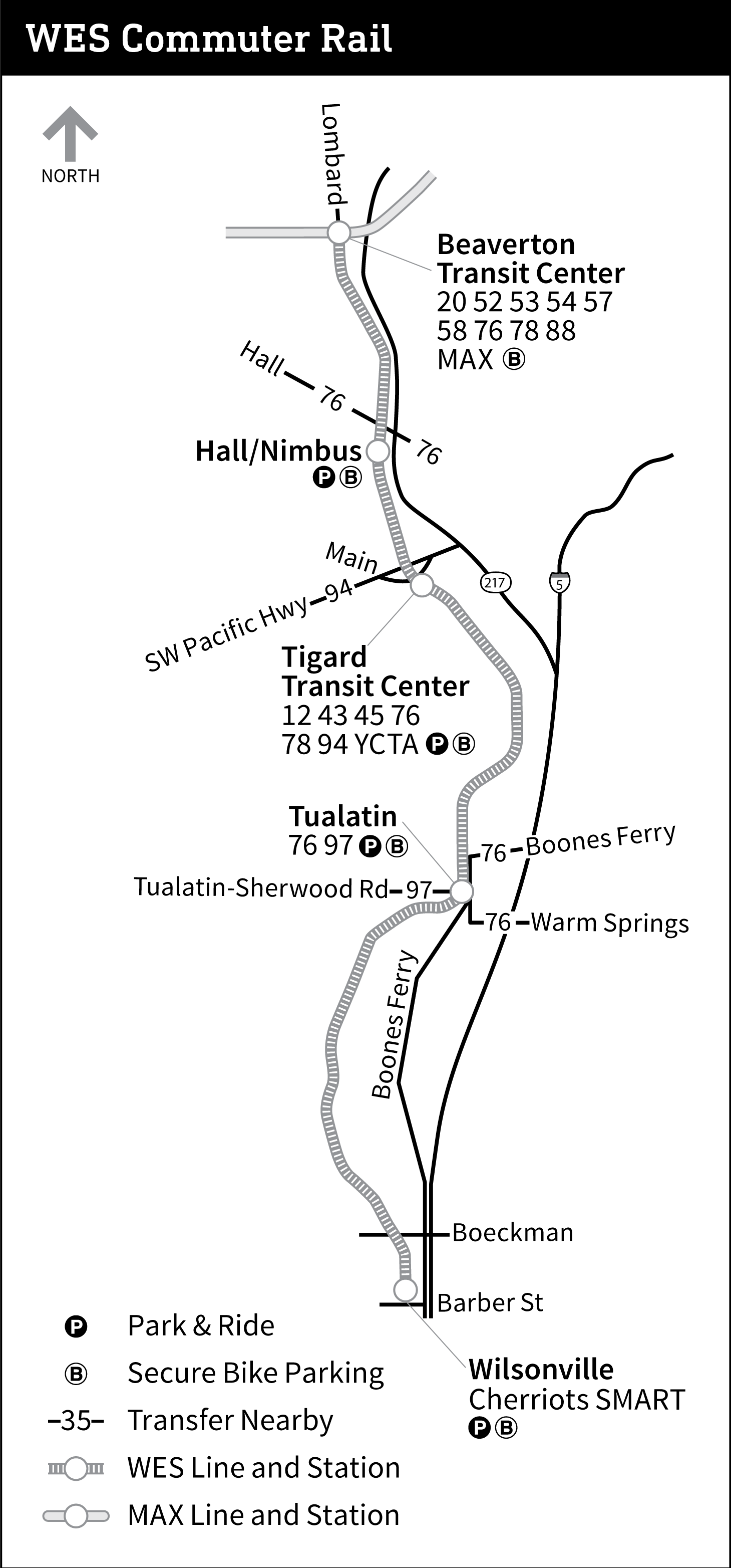
MAX stations facilitate transfers to other modes of transportation. Eleven stations operate as TriMet transit centers, providing connections to several local and intercity bus lines.[135] Currently, Beaverton Transit Center is the only MAX-served transit center with a transfer to WES Commuter Rail, which connects the cities Beaverton, Tigard, Tualatin, and Wilsonville.[136] On the Portland Transit Mall, trains connect with numerous bus lines, which have stops in blocks that are not occupied by light rail platforms.[137] In downtown Portland and the Central Eastside, riders can transfer to the Portland Streetcar at stations near points where MAX and streetcar lines intersect.[138] Riders may also connect to Amtrak via two stations near Portland Union Station.[137] The Red Line operates as an airport rail link and TriMet operates a MAX station at Portland International Airport.[139]
On July 24, 2019, TriMet announced the permanent closure of the Mall stations and a one-year pilot closure of Kings Hill/Southwest Salmon Street station. These closures, a first for the MAX system in an effort to speed up travel times, took effect on March 1, 2020.[1]
Accessibility and safety


MAX is fully accessible, having achieved this designation in April 1999.[5]: 53 Platforms and ticket vending machines provide information in audio, raised lettering, and braille. The edge of platforms have tactile paving and non-street level platforms may be accessed with elevators.[132] Most light rail cars, with the exception of Type 1, are low-floor and have ramps that extend onto station platforms to allow boarding of mobility devices. All cars have spaces and priority seating areas reserved for seniors and people with disabilities. Service animals are permitted aboard trains.[140]
Stations on the original MAX line were built with wayside lifts to accommodate riders with disabilities on the high-floor, first-generation vehicles. The lifts were installed on platforms rather than on trains to prevent malfunctions from delaying services.[141] Increased use of the lifts eventually became the cause of delays[142] and many users felt stigmatized by the lifts' "box" design and time-consuming operation.[5]: 54 With the passing into law of the Americans with Disabilities Act (ADA), TriMet submitted a paratransit plan to the FTA in January 1992.[5]: 53 Just before the start of the Westside MAX project, MAX became the first light rail system in North America to procure low-floor vehicles after a TriMet study of European systems.[142] The low-floor cars, which were jointly developed by TriMet and Siemens,[143] entered service in August 1997.[5]: 54
In 2011, TriMet began upgrading the oldest sections of the Blue Line to improve pedestrian safety and compliance with updated ADA standards.[144] In 2013, pipe barriers were installed at Gateway Transit Center platform crossings to force pedestrians to slow down and face oncoming trains before crossing the tracks. In 2014, TriMet realigned sidewalks and crosswalks at four at-grade crossings in Gresham. Other improvements made throughout the line include the installation of pedestrian warning signals and the upgrading of tactile paving.[145]
Parking facilities
As of 2019, TriMet provides 12,614 park and ride spaces, of which 10,219 directly serve MAX stations.[146]: 3 They are all located outside Portland's city center and are free to use. TriMet allows vehicles to park at most stalls overnight as long as they do not remain for more than 24 hours.[147] Most facilities are surface parking lots while some are multi-level parking garages.[146]: 2 At certain locations, TriMet negotiates with nearby establishments for additional spaces.[148] The Westside MAX has 3,643 parking spaces, the highest number of spaces in a corridor.[146]: 3 Clackamas Town Center Transit Center on the Green Line has 750 spaces, the largest capacity parking facility of any single station on the MAX network.[149]
_-_2.jpg)
Passengers originating from official TriMet park and ride facilities account for 5% of TriMet's total weekday ridership. In 2017, the Orange Line exhibited a 100% usage rate of its available spaces, followed by 85% along the Blue Line's westside segment. The corridor with the lowest use is the Green Line's I-205 segment at 30%. TriMet attributes this to several factors, including inconvenient lot access and the Green Line's indirect route to downtown Portland compared to the availability of more direct bus routes. The cost-per-space for building park and ride facilities is estimated at $18,000 per surface-lot space and $52,000 per structured space.[146]: 3–5
TriMet provides four bicycle parking options at its MAX stations, although not all options are available at every station.[150] Bike and ride facilities are secure, enclosed spaces that are accessible by keycard and are monitored 24 hours per day by security cameras; as of 2020[update] they are available at seven stations,[151] with more planned at other locations.[152] Similar to bike and ride, electronic bicycle lockers, or eLockers, are secure lockers that may be accessed by keycard and are made available on a first-come, first-served basis. TriMet contracts all keycard access to BikeLink.[153] Reserved lockers have slots that are rented out to users.[154] Bicycle racks, the network's commonest form of bicycle parking, are available at most stations.[155]
Rolling stock
.jpg)
As of 2020[update], TriMet operates five models of light rail vehicles, of which two are successive upgrades of the same model. The agency designates its vehicles as "Type 1" through "Type 5". TriMet has 145 cars that vary in length from 89 feet (27.1 m) to 95 feet (29.0 m) and are all used interchangeably by every service on the network.[156] Because of Portland's relatively small 200-foot (61 m) downtown blocks,[157] trains operate with only one or two cars, preventing stationary trains from blocking intersections. Type 2 and 3 vehicles are capable of running singularly or coupled to another Type 1, 2, or 3 vehicle. Trainsets composed of one low-floor and one high-floor car allowed the removal of wayside lifts from all MAX stations.Type 4 and 5 cars can only be coupled to one another.[156]
Twenty-six Type 1 vehicles were manufactured for the Banfield light rail project by a joint venture between La Brugeoise et Nivelles and Bombardier beginning in 1983.[158] Type 1 vehicles are similar in design to Bombardier vehicles that had been used in Brussels and Rio de Janeiro;[158] the first of the high-floor vehicles arrived in Portland in 1984.[159]
In 1992, TriMet officials conducted an accessibility study and determined low-floor cars were the most cost-effective way to provide universal access to the system.[156] MAX subsequently became the first light rail system in North America to acquire low-floor train sets in 1993 when TriMet procured 39 model SD660 cars from Siemens.[160][161][162] These Type 2 cars were equipped with wheelchair ramps,[163] and entered service during the partial opening of the Westside MAX in 1997.[164] In 1999, TriMet ordered 17 more Type 2 cars for the Airport MAX project.[50][156] The system's 27 Type 3 vehicles, which were purchased as part of the Interstate MAX project and first brought into use in 2003, are the same model as the Type 2 vehicles with technical upgrades and new livery.[156][165]
Twenty-two Siemens S70 low-floor cars, which were designated Type 4, were purchased in conjunction with the I-205 MAX and Portland Transit Mall projects, and were first used in 2009. Type 4 cars have a more streamlined design and more seating, and are lighter and more energy-efficient than the previous models. The Type 4 cars were the first in the MAX network to use LED-type destination signs.[166] The second series of S70 cars, TriMet's Type 5 vehicles, were procured for the Portland–Milwaukie light rail project. TriMet placed an order for the Type 5 cars with Siemens in 2012 and delivery commenced in 2014.[167] These vehicles include some improvements over the Type 4 cars, including less-cramped interior seating, and improvements to the air-conditioning system and wheelchair ramps.[168][169]
On July 29, 2019, Siemens received from TriMet an order for 26 S700 light rail vehicles that are intended to replace the system's Type 1 vehicles. The first car is expected to be delivered in 2021.[143]
Maintenance facilities

.jpg)
TriMet's vehicle-maintenance complexes for the MAX system are the Ruby Junction facility in Gresham and the smaller Elmonica facility in Beaverton.[170][171] The Ruby Junction facility is located near Ruby Junction/East 197th Avenue station while the Elmonica facility is adjacent to Elmonica/Southwest 170th Avenue station; both are on the Blue Line.[172]
Ruby Junction began with one building that was built as part of the original MAX project in the early 1980s; it was expanded to three multi-story buildings totaling 143,000 square feet (13,300 m2) occupying 17 acres (6.9 ha) by 2010,[170] and to four buildings totalling 149,000 square feet (13,800 m2) occupying 23 acres (9.3 ha) by 2016.[171] It has 13 maintenance bays and its yard tracks have the capacity to store 87 light rail cars.[171] In 2016, around 200 employees were working at Ruby Junction and almost 200 MAX operators were operating trains that were based there.[171]
The Elmonica facility was built as part of the Westside MAX Project in the mid-1990s and was completed in 1996.[173] Its building has 78,000 square feet (7,200 m2) of space.[173] In addition to vehicle maintenance, crews who maintain the MAX system's tracks and signals are also based at Ruby Junction.[171] In 2015, some of TriMet's MAX maintenance-of-way personnel moved into the defunct Portland Vintage Trolley carbarn next to Rose Quarter Transit Center, after Vintage Trolley service was discontinued, under a plan that was first described in 2013.[174]
Services
From Monday to Thursday, MAX trains run for 221⁄2 hours per day. Additional late-night trips are provided on Fridays. Except for additional late-night trips on Saturdays, weekend service runs on a slightly reduced schedule.[175] TriMet designates all MAX lines as "Frequent Service" routes, which ensures service runs on a 15-minute headway for most of each day.[176] During the early morning and late evening hours, trains operate with headways of up to 30 minutes. During rush hours, headways can be as short as three minutes, particularly in the central section of the system where lines overlap.[4] At many stations, a live display shows the destination and time-to-arrival of the next several trains using data gathered by a vehicle tracking system installed on the light rail tracks.[177]
Ridership
MAX carried over 38.8 million total passengers in 2019, an average of 120,900 riders per day on weekdays. This is slightly lower than the number of riders recorded in 2018 and represents the system's third consecutive year of fallen ridership. MAX ridership peaked in 2012, when the system recorded around 42.2 million annual passengers. 2016 marks the last year ridership increased; this was due to the opening of the Orange Line.[2] TriMet attributes falling ridership to perceived crime within trains and stations and lower-income riders being forced out of the inner city by rising housing prices.[178][179]
As of 2019[update], MAX remains the fourth-busiest light rail system in the United States after the light rail services of Metro Rail in Los Angeles, the MBTA in Boston, and Muni Metro in San Francisco.[180]
| Year | Ridership | %± |
|---|---|---|
| 2000 | 21,165,600 | — |
| 2005 | 31,920,000 | +50.8% |
| 2010 | 38,390,400 | +20.3% |
| 2011 | 41,200,160 | +7.3% |
| 2012 | 42,193,180 | +2.4% |
| 2013 | 39,036,500 | –7.5% |
| 2014 | 38,228,800 | –2.1% |
| 2015 | 37,746,000 | –1.3% |
| 2016 | 40,019,560 | +6.0% |
| 2017 | 39,699,760 | –0.8% |
| 2018 | 38,906,694 | –2.0% |
| 2019 | 38,817,600 | –0.2% |
| Source: TriMet[2] | ||
Graphs are unavailable due to technical issues. There is more info on Phabricator and on MediaWiki.org. |
Fares
.jpg)
.jpg)
As is standard practice on North American light rail systems,[181] MAX uses a proof-of-payment fare collection system and its stations do not have ticket barriers.[126] Most ticket vending machines at stations accept cash as well as credit and debit cards but some machines accept only cards.[182] TriMet employs an automated fare collection system through a stored-value, contactless smart card called Hop Fastpass,[183] which can be purchased from participating retail stores.[184] Alternatively, chip-embedded, single-use tickets may be purchased from ticket vending machines.[185] A virtual card is available to Android and Apple users.[186][187] Smartphones with a debit or credit card loaded into Google Pay, Samsung Pay, or Apple Pay can also be used on the MAX network.[188] Portland Streetcar ticket vending machines issue two-and-a-half-hour tickets and one-day passes that are valid on MAX.[189]
Before boarding a MAX train, riders must tap their fare medium onto one of the card readers that are located within the station.[184] Fares are flat rate and are capped according to use.[190] Using Hop Fastpass, riders may transfer to other TriMet services, C-Tran, and the Portland Streetcar.[191]
| Rider[191] | 21⁄2-hour ticket | Day Pass | Month Pass |
|---|---|---|---|
| Adult | $2.50 | $5 | $100 |
| Youth, Honored Citizen | $1.25 | $2.50 | $28 |
Discontinued services
From the MAX system's opening until 2012, riding trains within Fareless Square, which was known as the Free Rail Zone from 2010 to 2012, was free of charge. Fareless Square included all of downtown and, starting in 2001, part of the Lloyd District. The 37-year-old fare-free zone was discontinued on September 1, 2012, as part of system-wide cost-cutting measures. As part of the same budget cuts, TriMet discontinued its zonal fares and moved to a flat-fare system. Zones had been in place since 1986; higher fares were charged for longer journeys across three zones.[66]
The MAX Mall Shuttle operated on weekday afternoons from when it was introduced on September 14, 2009, until 2011.[192] It acted as a supplement to the light rail service provided on the Portland Transit Mall by the Green and Yellow lines.[193] The Mall Shuttle operated between Union Station and Portland State University every 30 minutes from noon until 5:30 p.m.[193] TriMet discontinued this supplementary shuttle service on June 5, 2011.[194][195] Along with bus services, the mall continues to be served by two MAX lines in each direction—Green and Yellow lines northbound and Green and Orange lines southbound—which provide a combined average headway of 7.5 minutes in each direction at most times.
The Portland Vintage Trolley operated on the MAX system on most weekends from 1991 until 2014, serving the same stops. This service used 1991-built replicas of 1904 Portland streetcars. Originally, the Vintage Trolley service followed a section of the original MAX line between the Library and Galleria stations and Lloyd Center. In September 2009, the service moved to the newly opened MAX alignment along the transit mall, running between Union Station to Portland State University,[98][196] and remained on this route in subsequent seasons. In 2011, the service was reduced to seven or eight Sundays per year,[197] and in July 2014 it was discontinued entirely and the two remaining faux-vintage cars were sold to a group planning a streetcar line in St. Louis.[198][199]
2017 stabbing incident

On May 26, 2017, at approximately 4:30 pm, a man fatally stabbed two people and injured a third after he was confronted for shouting anti-Muslim slurs at two teenage girls inside a MAX train.[200] Two men—a technician and U.S. Army veteran, and a recent university graduate—died from wounds to their necks while a third victim, who is also male, survived.[201] The attacker, who described himself as a white nationalist,[202] was arrested and charged with murder, attempted murder, and other crimes.[203] On February 21, 2020, the perpetrator was found guilty on all charges, including two counts of first-degree murder.[204]
See also
Notes
- ^ Until the opening of the Airport MAX extension, the service between Hillsboro and Gresham, which ran the entire length of the Eastside and Westside MAX segments, had simply been referred to as MAX. Color designations were adopted in September 2000 and implemented on September 10, 2001.[27][97]
- ^ Red Line service was extended on September 1, 2003, to a portion of the Westside MAX that was already being served by the Blue Line, between the Library and Galleria stations in downtown Portland and Beaverton Transit Center in Beaverton.[56]
- ^ On August 30, 2009, the Yellow Line was rerouted from its downtown alignment on First Avenue and Morrison and Yamhill streets, which it had shared with the Blue and Red lines, to the newly-added light rail tracks on the Portland Transit Mall.[64]
References
- ^ a b Altstadt, Roberta (July 24, 2019). "TriMet to make MAX service more efficient with closure of three stations in Downtown Portland in March 2020". TriMet. Archived from the original on July 24, 2019. Retrieved July 24, 2019.
- ^ a b c d "TriMet Service and Ridership Information" (PDF). TriMet. September 20, 2018. Archived (PDF) from the original on February 25, 2020. Retrieved August 8, 2019.
- ^ a b "TriMet At-A-Glance". TriMet. January 2016. Retrieved March 28, 2016.
- ^ a b c d e f "Power, Signals and Traffic Interface" (PDF). TriMet. July 2016. Retrieved March 20, 2019.
- ^ a b c d e f g h i j k l m n o p q r Selinger, Philip (2015). "Making History: 45 Years of Transit in the Portland Region" (PDF). TriMet. OCLC 919377348. Archived from the original on May 9, 2018. Retrieved July 26, 2018.
{{cite web}}: CS1 maint: unfit URL (link) - ^ Thompson, Richard M. (2010). Portland's Streetcar Lines. Arcadia Publishing. pp. 7–8. ISBN 978-0-7385-8126-2. Retrieved March 12, 2019.
- ^ "A History of Public Transit in Portland". TriMet. Archived from the original on December 7, 2018. Retrieved December 7, 2018.
- ^ "Portland's Interurban Years". TriMet. Archived from the original on December 5, 2018. Retrieved December 5, 2018.
{{cite web}}:|archive-date=/|archive-url=timestamp mismatch; December 6, 2018 suggested (help) - ^ Thompson, Richard (2006). Portland's Streetcars. Arcadia Publishing. pp. 9–17. ISBN 978-1-4396-3109-6. Retrieved March 11, 2019.
- ^ a b Thompson, Richard M. (2012). Portland's Interurban Railway. Arcadia Publishing. ISBN 978-0-7385-9617-4.
- ^ Young, Bob (March 8, 2005). "Highway to Hell". Willamette Week. Archived from the original on September 17, 2018. Retrieved July 26, 2018.
- ^ Paglin, Morton (June 28, 2004). "Effort to stop freeway remembered". The Oregonian. p. B6.
- ^ United States. Federal Highway Administration (1975). West Portland Park-and-ride, Pacific Hwy, I-5, Multnomah County: Environmental Impact Statement (Report). Federal Highway Administration. p. 11. Retrieved July 26, 2018.
- ^ "Meetings on transit ideas slated". The Oregonian. May 4, 1975. p. C2.
- ^ "Tri-Met board backs Banfield rail option". The Oregonian. February 8, 1977. p. 1.
- ^ Hortsch, Dan (September 27, 1978). "Tri-Met board votes to back Banfield light-rail project". The Oregonian. p. F1.
- ^ Federman, Stan (March 27, 1982). "At ground-breaking: Festivities herald transitway". The Oregonian. p. A12.
- ^ Koberstein, Paul (September 7, 1986). "Riders swamp light rail as buses go half-full and schedules go by the way". The Oregonian. p. A1.
- ^ Anderson, Jennifer (May 5, 2006). "Stumptown Stumper". Portland Tribune. Retrieved August 21, 2012.
- ^ "Banfield Light Rail Eastside MAX Blue Line" (PDF). TriMet. July 2016. Retrieved September 29, 2018.
- ^ a b United States. Federal Transit Administration (1994). Hillsboro Extension of the Westside Corridor Project, Washington County: Environmental Impact Statement (Report). Federal Transit Administration. p. P1–P5. Retrieved July 29, 2018.
- ^ Federman, Stan (November 7, 1987). "Tri-Met heats up study for westside light rail". The Oregonian. p. E14.
- ^ Hamilton, Don (February 23, 2000). "Shirley Huffman, fiery lobbyist, earns praise; Hard work and a sharp phone call put light-rail trains into downtown Hillsboro". The Oregonian. p. E2.
- ^ Oliver, Gordon (August 8, 1993). "Groundbreaking ceremonies set to launch project". The Sunday Oregonian. "Westside Light Rail: Making Tracks" (special section), p. R1.
- ^ O'Keefe, Mark (September 1, 1997). "New MAX cars smooth the way for wheelchairs". The Oregonian. p. B12.
- ^ Oliver, Gordon; Hamilton, Don (September 9, 1998). "Go west young MAX". The Oregonian. p. C1.
- ^ a b c Stewart, Bill (September 21, 2000). "Local colors roll out: Tri-Met designates the Blue, Red and Yellow lines". The Oregonian. pp. E1, E10.
- ^ "Where's east side light rail going next?". The Oregonian. April 3, 1986. p. 2.
- ^ Briggs, Kara (July 24, 2002). "Metro considers transit options along I-205". The Oregonian. p. D2.
- ^ Redden, Jim (September 10, 2009). "After 35 years of waiting, TriMet's Green Line hits all the parties: Thousands ride new I-205 line that was born of a '70s freeway rebellion". Portland Tribune. Archived from the original on June 8, 2011. Retrieved May 13, 2014.
- ^ Kohler, Vince (May 23, 1988). "Joint efforts of business, government could spur rail line; both groups need to finance, back line along I-205, panel says". The Oregonian. p. B5.
- ^ Kohler, Vince; Stewart, Bill (September 10, 1989). "Light-rail proposals gain ground in Congress; senate panel approves transportation funding bill, aiding plans for new Oregon City, Vancouver lines". The Oregonian. p. C2.
- ^ Stewart, Bill (January 12, 1993). "County light-rail project gains momentum". The Oregonian. p. B2.
- ^ Oliver, Gordon (March 11, 1993). "Citizens advisory committee endorses pair of light-rail routes". The Oregonian. p. B3.
- ^ Oliver, Gordon (March 7, 1993). "Decisions to be made soon on north–south light rail". The Oregonian. p. C4.
- ^ Leeson, Fred (February 13, 1994). "Planners narrowing options for north–south light-rail line". The Oregonian. p. C5.
- ^ McCarthy, Dennis (September 15, 1994). "Light-rail service? On to Oregon City!". The Oregonian. p. D2.
- ^ Stewart, Bill (February 8, 1995). "Clark County turns down north–south light rail". The Oregonian. p. A1.
- ^ Oliver, Gordon; Stewart, Bill (March 1, 1995). "MAX may skip Clark County, N. Portland". The Oregonian. p. B1.
- ^ Green, Ashbel S.; Mapes, Jeff (August 4, 1995). "Legislature is finally working on the railroad". The Oregonian. p. A1.
- ^ a b "Some light-rail history". The Oregonian. October 7, 1996. p. A8.
- ^ Spicer, Osker (January 31, 1996). "Light-rail would be good for areas". The Oregonian. p. C2.
- ^ Oliver, Gordon; Hunsenberger, Brent (November 7, 1996). "Tri-Met still wants that rail line to Clackamas County". The Oregonian. p. D1.
- ^ Oliver, Gordon (February 12, 1997). "South–north light-rail issue keeps on going". The Oregonian. p. A1.
- ^ Oliver, Gordon (November 7, 1998). "South–north line backers find themselves at a loss after election day defeat". The Oregonian. p. B1.
- ^ Marks, Anita (February 25, 1994). "Airport struggles with runaway growth". Portland Business Journal. p. 1.
- ^ a b Oliver, Gordon (January 22, 1997). "Port wants MAX to run to airport". The Oregonian. p. A1.
- ^ a b c "Airport MAX Red Line" (PDF). TriMet. July 2016. Archived from the original (PDF) on August 28, 2018. Retrieved August 24, 2018.
- ^ Rose, Michael (December 19, 1997). "PDX light rail may lead to south-north line". Portland Business Journal. p. 1.
- ^ a b Stewart, Bill (June 17, 1999). "Light-rail line to PDX starting to take shape". The Oregonian. p. B1.
- ^ Oliver, Gordon (September 10, 1998). "Light rail to airport gets closer to reality". The Oregonian. p. B1.
- ^ Oliver, Gordon (September 11, 2001). "Portland now 'the city that moves', mayor says [opening of MAX Red Line]". The Oregonian. p. 1.
- ^ Oliver, Gordon (September 21, 2001). "Unknowns cloud PDX's future". The Oregonian. p. D1.
- ^ "History cancels PDX party". The Oregonian. September 15, 2001. p. D8.
- ^ Stewart, Bill (September 7, 2001). "Airport MAX rolls out Monday". The Oregonian. p. B1.
- ^ a b Leeson, Fred (August 27, 2003). "MAX fares increase, direct service from Beaverton to PDX starts". The Oregonian. p. D2.
- ^ Oliver, Gordon (March 16, 1999). "New light-rail plan rises from the ashes". The Oregonian. p. 1.
- ^ Stewart, Bill (March 25, 1999). "Tri-Met involvement urged in north light-rail line". The Oregonian. p. B3.
- ^ Oliver, Gordon (May 3, 1999). "Tri-Met adds detail to proposal to build light rail in the north". The Oregonian. p. C2.
- ^ Stewart, Bill (February 16, 2001). "Interstate MAX work will begin with Monday ceremony". The Oregonian. p. D3.
- ^ Stewart, Bill (August 26, 1999). "Interstate MAX on track but not final". The Oregonian. p. D2.
- ^ Stewart, Bill (February 5, 2000). "NW prominent in Clinton money plan. MAX: The North Portland Interstate". The Oregonian. p. A1.
- ^ Leeson, Fred (April 25, 2004). "The Yellow Line: Open for business". The Oregonian. p. B5.
- ^ a b c d "New MAX line opens downtown". Portland Tribune. August 28, 2009. Archived from the original on January 3, 2015. Retrieved May 13, 2014.
- ^ Redden, Jim (September 24, 2009). "Line's last piece stirs money questions". Portland Tribune. Retrieved September 2, 2012.
- ^ a b Bailey Jr., Everton (August 30, 2012). "TriMet boosts most fares starting Saturday; some routes changing". The Oregonian. Retrieved September 2, 2012.
- ^ a b Lum, Brian (June 19, 2015). "You asked: How will the Orange Line work in downtown Portland?". TriMet. Archived from the original on October 26, 2015.
{{cite web}}: CS1 maint: unfit URL (link) - ^ Rose, Joseph (May 8, 2001). "New MAX plan tries the double-team approach". The Oregonian. p. D1.
- ^ Rose, Joseph (June 6, 2001). "Metro planners will study two south light-rail lines". The Oregonian. p. E3.
- ^ a b Oppenheimer, Laura (January 27, 2003). "New MAX plans arrive for input; a revived bid to expand light rail to Milwaukie, one of five transit proposals, may fare better now that former critics are on board". The Oregonian. p. E1.
- ^ Leeson, Fred (March 27, 2003). "TriMet board agrees to plan for southeast light-rail lines". The Oregonian. p. C2.
- ^ Oppenheimer, Laura (April 18, 2003). "Metro gives final OK to MAX lines". The Oregonian. p. D6.
- ^ a b Leeson, Fred (April 15, 2003). "Light-rail line likely addition to transit mall". The Oregonian. p. B1.
- ^ Mayer, James (February 8, 2006). "Metro rail projects hit funding fast track". The Oregonian. p. A1.
- ^ Mayer, James (February 8, 2007). "Light rail in Bush's 2008 budget". The Oregonian. p. C5.
- ^ Rivera, Dylan (September 13, 2009). "Thousands on MAX go Green Festivities and free rides draw takers for the new downtown–Clackamas Town Center line". The Oregonian.
- ^ McCarthy, Dennis (December 20, 2001). "Milwaukie group poses surprise light-rail option". The Oregonian. p. C3.
- ^ Mortenson, Eric (May 2, 2008). "Panel realigns route of new light-rail span". The Oregonian. p. D1.
- ^ a b Libby, Brian (October 2015). "Bridge to the Future (The Bridge that Bans Cars)". The Atlantic. 316 (3): 42–43. Retrieved September 27, 2015.
- ^ Rose, Joseph (June 29, 2011). "Construction begins on new light-rail bridge in Portland that will go up 'piece by piece'". The Oregonian. Retrieved July 27, 2013.
- ^ Theriault, Denis C. (May 31, 2012). "Checkpoint Clackamas! Keeping Portland Out—to Let More Republicans In?". The Portland Mercury. Retrieved February 22, 2016.
- ^ Zheng, Yuxing (September 18, 2012). "Clackamas County anti-rail measure passes comfortably; effect could resonate for decades". The Oregonian. Retrieved February 22, 2016.
- ^ Selinger, Philip (October 2019). "Making History: 50 Years of Transit in the Portland Region" (PDF). TriMet. Archived from the original (PDF) on February 25, 2020. Retrieved February 25, 2020.
- ^ Njus, Elliot (September 12, 2015). "The wait's over: TriMet's Orange Line, Tilikum Crossing up and running". The Oregonian. Retrieved September 18, 2015.
- ^ a b c Public Review Draft, 2018 Regional Transportation Plan, Chapter 6: Regional Programs and Projects to Achieve Our Vision (PDF) (Report). Metro. June 29, 2018. p. 15, 19. Retrieved April 23, 2019.
- ^ "MAX Red Line Improvements Project" (PDF). TriMet. Archived from the original on July 15, 2019. Retrieved April 25, 2019.
{{cite web}}: CS1 maint: unfit URL (link) - ^ Howard, John (October 26, 2017). "TriMet considering expansion of MAX Red Line to county fairgrounds". Portland Tribune. Retrieved November 7, 2017.
- ^ "Southwest Corridor Light Rail Project (Factsheet)" (PDF). TriMet. Archived (PDF) from the original on July 22, 2019. Retrieved July 22, 2019.
- ^ Pitz, Ray (February 5, 2020). "New details on SW Corridor MAX stations include Bridgeport". Portland Tribune. Retrieved February 14, 2020.
- ^ a b Southwest Corridor Light Rail Project Conceptual Design Report (PDF) (Report). TriMet. 2020. Retrieved February 5, 2020.
- ^ Mesh, Aaron (June 13, 2018). "The Price Tag on Light Rail to Bridgeport Village Has Grown by Nearly a Billion Dollars". Willamette Week. Retrieved June 13, 2018.
- ^ a b c "The MAX Tunnel Study: Examining the feasibility of faster light rail" (PDF). Metro. Retrieved November 4, 2019.
- ^ Njus, Elliot (June 14, 2017). "City planners float idea of subway tunnel through downtown Portland". The Oregonian. Retrieved June 24, 2017.
- ^ Peel, Sophie (June 28, 2019). "The Idea for MAX Tunnel Under Downtown Emerged From Examination of How to Fix the Steel Bridge Bottleneck". Willamette Week. Retrieved June 28, 2019.
- ^ a b Rivera, Dylan (September 5, 2009). "MAX Green Line signals decades of rail growth". The Oregonian. Retrieved May 15, 2019.
- ^ a b c Rail System Map with transfers (PDF) (Map). TriMet. Retrieved July 25, 2018.
- ^ a b Briggs, Kara (August 29, 2001). "Airport MAX light-rail service in sight". The Oregonian. p. C2.
- ^ a b c Morgan, Steve (2010). "Expansion for Portland's MAX: New routes and equipment". Passenger Train Journal. 33 (1 – First quarter 2010). White River Productions, Inc.: 38–40.
- ^ Lum, Brian (June 19, 2015). "You asked: How will the Orange Line work in downtown Portland?". TriMet. Archived from the original on October 26, 2015.
{{cite web}}: CS1 maint: unfit URL (link) - ^ "MAX Blue Line Map and Sechdule". TriMet. Retrieved November 2, 2008.
- ^ "MAX Green Line Map and Sechdule". TriMet. Retrieved September 12, 2009.
- ^ "MAX Orange Line Map and Sechdule". TriMet. Retrieved February 18, 2016.
- ^ "MAX Red Line Map and Sechdule". TriMet. Retrieved November 2, 2008.
- ^ "MAX Yellow Line Map and Sechdule". TriMet. Retrieved November 2, 2008.
- ^ "Banfield Light Rail Eastside MAX Blue Line" (PDF). TriMet. July 2016. Retrieved August 2, 2018.
- ^ Shedd, Tom (November 1987). "MAX: Portland's Light Rail Is an Instant Success". Modern Railroads. Chicago, Illinois: International Thomson Transport Press. pp. 14–15. ISSN 0736-2064.
- ^ Special Report 221 – Light Rail Transit: New System Successes at Affordable Prices (PDF). Transportation Research Board. 1989. pp. 25, 34, 90, 92, 317, 319, 468. ISBN 0-309-04713-7.
- ^ Wade, Michael (November 17, 1986). "Popularity of MAX spearheads boost in Tri-Met ridership". The Oregonian. p. B4.
- ^ "Westside MAX Blue Line Extension" (PDF). TriMet. July 2016. Retrieved April 22, 2019.
- ^ Sebree, Mac (1994). "Portland's Westside Tunnel: An LRT Breakthrough". 1994 Light Rail Annual & User's Guide. Pasadena, CA: Pentrex. pp. 10–14. ISSN 0160-6913.
- ^ a b "Interstate MAX Yellow Line" (PDF). TriMet. July 2016. Archived from the original (PDF) on July 10, 2018. Retrieved February 23, 2019.
- ^ a b "I-205/Portland Mall MAX Green Line" (PDF). TriMet. July 2016. Retrieved April 22, 2019.
- ^ a b "Finance [part of monthly news section]". Railway Gazette International. August 2007. p. 470.
- ^ a b "Portland–Milwaukie MAX Orange Line" (PDF). TriMet. July 2016. Archived (PDF) from the original on April 23, 2019. Retrieved May 14, 2019.
- ^ "TriMet offers three options for MAX tracks". The Oregonian. July 4, 2003. p. D1.
- ^ Leeson, Fred (April 1, 2004). "Likely plan for train, bus boarding leans right". The Oregonian. p. B2.
- ^ a b "Tilikum Crossing, Bridge of the People, brings new connections and new options in 2015" (PDF). TriMet. June 2014. Retrieved February 7, 2020.
- ^ a b Tri-County Metropolitan Transportation District of Oregon (November 1, 1981). Banfield Light Rail Project: Conceptual Design Information for the City of Portland (Report). Vol. 9. TriMet Collection. Archived from the original on September 28, 2015. Retrieved July 27, 2018.
- ^ Stewart, Bill (December 17, 1999). "Don't look up, but MAX bridge going in over I-205; strict safety measures are in place to protect motorists, and as the span is built, tracks will start going in on Airport Way". The Oregonian. p. A1.
- ^ Stewart, Bill; Leeson, Fred (February 26, 2001). "Interstate MAX may cross one of city's longest spans". The Oregonian. p. C3.
- ^ Mayer, James (April 13, 1991). "Board picks light-rail tunnel". The Oregonian. p. 1.
- ^ Redden, Jim (August 23, 2008). "Steel Bridge reopened with changes". Portland Tribune. Archived from the original on November 7, 2018. Retrieved July 16, 2019.
- ^ a b c d "Light Rail Stations" (PDF). TriMet. August 2016. Retrieved August 5, 2019.
- ^ Running, Jim (August 18, 1983). "16-block tear-up for light-rail delayed". The Oregonian. p. B1.
- ^ Howell, Jim (August 13, 2003). "Analyze subway benefits before tearing up transit mall". The Oregonian. p. C9.
- ^ a b Rose, Joseph (March 20, 2015). "Fare turnstiles coming to Portland-Milwaukie MAX stations". The Oregonian. Retrieved August 6, 2019.
- ^ "Station furnishings, equipment and signage" (PDF). TriMet. February 2010. p. 89. Retrieved August 6, 2019.
- ^ Blevins, Drew (July 23, 2013). "We're adding arrival screens at more Blue and Red Line MAX stations". How We Roll. TriMet. Archived from the original on April 11, 2016. Retrieved April 5, 2015.
- ^ "Beaverton Transit Center". TriMet. Retrieved April 17, 2018.
- ^ "Sunset Transit Center". TriMet. Retrieved April 17, 2018.
- ^ Chan, Kenneth (March 16, 2019). "Former SkyTrain manager trying to speed up Portland's street-level LRT". Daily Hive. Retrieved August 6, 2019.
- ^ a b Becker, Tim (May 1, 2018). "TriMet launching multi-year, multi-million dollar elevator improvement program". TriMet. Archived from the original on August 6, 2019. Retrieved August 6, 2019.
- ^ "Lents Town Center/SE Foster Road station, 3D satellite view" (Map). Google Maps. Retrieved August 6, 2019.
- ^ Altstadt, Roberta (August 2, 2019). "UPDATE: TriMet to replace elevators at the deepest transit station in North America". TriMet. Archived from the original on August 6, 2019. Retrieved August 6, 2019.
- ^ "Transit Centers". TriMet. Retrieved December 3, 2018.
- ^ WES Commuter Rail (Map). TriMet. Retrieved December 1, 2018.
- ^ a b Portland City Center and Transit Mall (PDF) (Map). TriMet. Archived from the original (PDF) on February 10, 2019. Retrieved July 30, 2018.
- ^ "Maps + Schedules - Portland Streetcar". Portland Streetcar. Archived from the original on February 10, 2019. Retrieved October 11, 2018.
- ^ "Stop ID 10579 – Portland Int'l Airport MAX Station". TriMet. Retrieved August 5, 2019.
- ^ "Accessibility Features on MAX". TriMet. Archived from the original on August 8, 2019. Retrieved August 8, 2019.
- ^ "Banfield Light Rail Eastside MAX Blue Line" (PDF). TriMet. July 2016. Retrieved August 2, 2018.
- ^ a b "Westside Light Rail MAX Blue Line extension (fact sheet)" (PDF). TriMet. November 2009. Retrieved January 23, 2011.
- ^ a b Corselli, Andrew (July 29, 2019). "Siemens Receives Two LRV Orders". Railway Age. Retrieved July 29, 2019.
- ^ Nunez, Jenifer (November 14, 2013). "TriMet begins pedestrian safety upgrades along MAX Blue Line". RT&S. Archived from the original on August 3, 2018. Retrieved August 2, 2018.
- ^ Murphy, Angela (November 13, 2013). "Renew the Blue moving forward along Eastside MAX Blue Line". TriMet News. Archived from the original on August 3, 2018. Retrieved August 3, 2018.
- ^ a b c d "Southwest Corridor Light Rail Project: A Primer on Station Access and Park & Rides" (PDF). TriMet. June 2019. Archived (PDF) from the original on February 20, 2020. Retrieved February 20, 2020.
- ^ "Park & Ride Locations". TriMet. Archived from the original on August 12, 2019. Retrieved August 12, 2019.
- ^ Longeteig, Andrew (July 25, 2016). "TriMet expands parking options in Milwaukie with new Park & Ride opening Aug. 1 near MAX Orange Line". TriMet. Archived from the original on August 12, 2019. Retrieved August 12, 2019.
- ^ "Park & Ride Locations Clackmas Town Center Parking Garage". TriMet. Retrieved February 22, 2020.
- ^ "Bikes and TriMet". TriMet. Archived from the original on August 13, 2019. Retrieved August 13, 2019.
- ^ Maus, Jonathan (January 30, 2019). "First look at TriMet's new Bike & Ride parking at Goose Hollow". BikePortland.org. Retrieved August 13, 2019.
- ^ "TriMet Bike & Rides". TriMet. Archived from the original on August 13, 2019. Retrieved August 13, 2019.
- ^ York, Tia (August 16, 2017). "Bike-to-ride culture, community pride reflected in dynamic new mural at Orenco Station Bike & Ride". TriMet. Archived from the original on August 13, 2019. Retrieved August 13, 2019.
- ^ "Reserved Bike Lockers". TriMet. Archived from the original on August 13, 2019. Retrieved August 13, 2019.
- ^ "Bike Racks". TriMet. Archived from the original on August 13, 2019. Retrieved August 13, 2019.
- ^ a b c d e "TriMet's Rail Vehicle Fleet" (PDF). TriMet. July 2016. Retrieved December 19, 2018.
- ^ Miskimins, Laurie. "The 200 foot Block: Creating a more walkable Portland". Portland Bureau of Transportation. Archived from the original on August 5, 2019. Retrieved August 5, 2019.
- ^ a b "'Roomy, good-looking' light-rail cars please Tri-Met official". The Sunday Oregonian. November 27, 1983. p. B5.
- ^ "First car for light rail delivered". The Oregonian. April 11, 1984. p. C4.
- ^ Oliver, Gordon (April 15, 1993). "Tri-Met prepares to purchase 37 low-floor light-rail cars". The Oregonian. p. D4.
- ^ Vantuono, William C. (July 1993). "Tri-Met goes low-floor: Portland's Tri-Met has broken new ground with a procurement of low-floor light rail vehicles. The cars will be North America's first low-floor LRVs". Railway Age. pp. 49–51. ISSN 0033-8826.
- ^ "LA And Portland Get New-Design LRVs". International Railway Journal. October 1993. pp. 26–27. ISSN 0744-5326.
- ^ Vantuono, William C. (February 12, 2016). "Retractable bridge plates a first for Brightline". Railway Age. Archived from the original on July 10, 2018. Retrieved July 9, 2018.
- ^ O'Keefe, Mark (September 1, 1997). "New MAX cars smooth the way for wheelchairs". The Oregonian. p. B12.
- ^ Leeson, Fred (August 14, 2002). "Hyphen and '70s hues left by the wayside". The Oregonian. p. C1.
- ^ Redden, Jim (August 6, 2009). "TriMet puts new light-rail cars on track". Portland Tribune. Archived from the original on August 31, 2009. Retrieved May 17, 2015.
- ^ Tramways & Urban Transit magazine, July 2015, p. 289. UK: LRTA Publishing. ISSN 1460-8324.
- ^ Rose, Joseph (July 31, 2012). "TriMet asks cramped MAX riders to help design next-generation train's seating". The Oregonian. Retrieved September 4, 2012.
- ^ "PMLR Type 5 LRV Fact Sheet" (PDF). TriMet. March 2015. Retrieved May 17, 2015.
- ^ a b Preusch, Matthew (April 23, 2010). "TriMet's Ruby Junction maintenance yard continues to grow with MAX". The Oregonian. Retrieved April 23, 2019.
- ^ a b c d e Carson, Teresa (July 29, 2016). "Ruby keeps MAX sparkling". The Outlook. Gresham, Oregon. Archived from the original on October 1, 2016. Retrieved April 23, 2019.
- ^ "Rail Maintenance Facilities" (PDF). TriMet. July 2016. Retrieved March 2, 2020.
- ^ a b Colby, Richard N. (January 22, 1996). "Light-rail milestone: The $16 million Westside MAX maintenance building in Elmonica is dedicated". The Oregonian (West Metro ed.).
- ^ Rose, Joseph (December 6, 2013). "TriMet on verge of sending Portland's vintage holiday trolleys to St. Louis". The Oregonian. Retrieved April 23, 2019.
- ^ "MAX Lines & Schedules". TriMet. Retrieved March 5, 2020.
- ^ "Frequent Service" (PDF). TriMet. Archived (PDF) from the original on May 9, 2018. Retrieved August 6, 2018.
- ^ "TransitTracker". TriMet. Retrieved March 2, 2020.
- ^ Keizur, Christopher (June 12, 2017). "Safe travels?". Portland Tribune. Archived from the original on August 4, 2018. Retrieved August 3, 2018.
- ^ Zielinski, Alex (May 18, 2018). "You Know Portland's Transportation Woes Have Reached a Breaking Point When..." Portland Mercury. Archived from the original on August 4, 2018. Retrieved August 3, 2018.
- ^ "Transit Ridership Report Fourth Quarter 2018" (PDF). American Public Transportation Association. April 12, 2018. Retrieved March 2, 2020.
- ^ Larwin, Thomas F.; Koprowski, Yung (November 2013). "Off-Board Fare Payment Using Proof-of-Payment Verification". Transportation Research Board. Retrieved November 26, 2018.
Since the late 1970s POP verification has become the standard fare collection technique employed by all modern light rail transit systems in North America.
- ^ "Ticket Machines". TriMet. Retrieved November 25, 2018.
- ^ "NXP helps the Portland-Vancouver Metro region move intelligence to the cloud with the new Hop Fastpass™ Transit Card used on Buses, the Light Rail and Streetcars". NXP Blog. October 9, 2017. Retrieved July 31, 2018.
- ^ a b Altstadt, Roberta (February 8, 2018). "Major retailers continue selling paper tickets as Hop Fastpass™ rollout continues". TriMet News. Retrieved August 1, 2018.
- ^ Altstadt, Roberta (May 16, 2018). "Hop Fastpass™ fare system takes more leaps forward with ticket machine, retail store transitions". TriMet News. Retrieved August 1, 2018.
- ^ Altstadt, Roberta (April 16, 2018). "Portland's Virtual Hop Fastpass™ transit card now available to all Google Pay users". TriMet News. Retrieved August 1, 2018.
- ^ Romero, Morgan (April 5, 2019). "TriMet adds Hop Fastpass to Apple Wallet as paper tickets are phased out". KGW. Retrieved August 1, 2019.
- ^ Lum, Brian (August 22, 2017). "You Can Now Use Hop With Just Your Phone". How We Roll, TriMet. Retrieved August 1, 2018.
- ^ "Fare Info: How to Purchase Fares". Portland Streetcar Inc. Retrieved March 11, 2019.
- ^ Njus, Elliot (July 10, 2017). "Hop Fastpass: The pros and cons of TriMet's new e-fare system". The Oregonian. Retrieved August 1, 2018.
- ^ a b "Hop fares". TriMet. Retrieved August 1, 2018.
- ^ "MAX Light Rail Service Begins on the Portland Mall". City of Portland's Office of Neighborhood Involvement. August 17, 2009. Retrieved October 10, 2009.
- ^ a b "Portland Transit Mall Bus Stops and MAX Stations from Union Station to PSU". TriMet. 2009. Archived from the original on June 13, 2010. Retrieved May 13, 2014.
- ^ Rose, Joseph (June 3, 2011). "TriMet will make several seasonal bus line adjustments Sunday". The Oregonian. Retrieved May 13, 2014.
- ^ "MAX Mall Shuttle". TriMet. 2011. Archived from the original on May 13, 2014. Retrieved May 13, 2014.
- ^ "Vintage Trolley 2012 Schedule on the Portland Mall". Portland Vintage Trolley website. Archived from the original on February 1, 2013. Retrieved February 6, 2014.
- ^ Tramways & Urban Transit, April 2011, p. 152. LRTA Publishing Ltd.
- ^ "Vintage Trolley Has Ceased Operation". Portland Vintage Trolley website. September 2014. Retrieved January 2, 2015.
- ^ "Portland double-track is brought into use". Tramways & Urban Transit. LRTA Publishing. November 2014. p. 454.
- ^ Bernstein, Maxine (May 29, 2017). "Portland MAX hero's last words: 'Tell everyone on this train I love them'". The Oregonian. Archived from the original on May 30, 2017.
- ^ Bernstein, Maxine (May 27, 2017). "MAX attack unfolded quickly: Extremist cut three in neck, police say". The Oregonian. Archived from the original on May 28, 2017.
- ^ Frankel, Todd C. (May 27, 2017). "Suspected attacker Jeremy Joseph Christian stood out amid rising tensions in Portland". The Washington Post. Archived from the original on May 29, 2017.
- ^ Bernstein, Maxine (June 7, 2017). "Indictment returned against accused MAX attack killer Jeremy Christian". The Oregonian. Archived from the original on June 6, 2017.
- ^ Mimica, Mila; Vespa, Maggie (February 21, 2020). "Jeremy Christian found guilty on all counts in MAX stabbing attack". KGW. Retrieved February 22, 2020.
External links
| Bus |
| ||||||||
|---|---|---|---|---|---|---|---|---|---|
| Rail |
| ||||||||
| Other | |||||||||
Italics denote lines or services which are planned, under construction, or otherwise not operating at the present time. | |||||||||
- MAX Light Rail
- 1986 establishments in Oregon
- 750 V DC railway electrification
- 825 V DC railway electrification
- Electric railways in Oregon
- Light rail in Oregon
- Passenger rail transportation in Oregon
- Railway lines opened in 1986
- Transportation in Hillsboro, Oregon
- Transportation in Multnomah County, Oregon
- Transportation in Washington County, Oregon
- TriMet