
Kanayama Station (Aichi)
Kanayama Station 金山駅 | |
|---|---|
 | |
| General information | |
| Location | Atsuta-ku and Naka-ku, Nagoya, Aichi Japan |
| Operated by |
|
| Connections |
|
This article needs additional citations for verification. (December 2009) |
Kanayama Station (金山駅, Kanayama-eki) is a railway station partly in Naka-ku, and partly in Atsuta-ku, Nagoya, Aichi Prefecture, Japan. This station is a concentrated terminal of JR Central, Meitetsu and Nagoya Municipal Subway. This is the main access terminal to Chūbu Centrair International Airport, and provides access to Nagoya/Boston Museum of Fine Arts.
JR Central Kanayama Station
Kanayama Station 金山駅 | |
|---|---|
| JR Central station | |
| General information | |
| Location | Kanayama 1-17-18, Naka-ku, Nagoya, Aichi (名古屋市中区金山一丁目17-18) Japan |
| Operated by | JR Central |
| Line(s) |
|
| History | |
| Opened | 1962 |
| Passengers | |
| 2008 | 56,759 daily |
JR Kanayama Station is one of the stations within Kanayama Station, and the second one to have been opened, on January 25, 1962, after Meitetsu Kanayama. It is a main stop on the Chūō Line and the Tōkaidō Line. On the Tōkaidō Main Line, there is a rapid train known as the Home Liner, and on the Chūō Main Line, there is a rapid train known as the Central Liner. There is a special wicket that allows passengers to transfer from JR lines to Meitetsu lines, which is possible because the Meitetsu tracks are within the JR tracks. There is also a service counter. Business hours at the ticket counter are from 5:30 am to 11:50 pm.[1]
Lines
- Tōkaidō Line
- Chūō Line
- for Nagoya
- for Kōzōji, Tajimi and Nakatsugawa
Layout
Platforms
| 1 | ■ Chūō Main Line | For Kōzōji, Tajimi, Mizunami, Ena, and Nakatsugawa |
| 2 | ■ Chūō Main Line | For Nagoya |
| 3 | ■ Tōkaidō Main Line | For Ōbu, Kariya, Okazaki, Toyohashi, and Taketoyo |
| 4 | ■ Tōkaidō Main Line | For Owari-Ichinomiya, Gifu, and Ōgaki |
There are two physical platforms for four lines. The two physical platforms straddle the platforms of Meitetsu Kanayama, which are sandwiched in the middle. Platforms 1 and 2 are for the Chūō Line, with Platform 1 serving trains bound for Tajimi Station and Platform 2 serving trains bound for Nagoya Station. Platforms 3 and 4 are for the Tōkaidō Line, with Platform 3 serving trains bound for Toyohashi Station and Platform 4 serving trains bound for Nagoya Station.[1]
The station is completely accessible inside the gates for passengers with disabilities.[2]
-
 Ticket Gate
 -
 Ticket Gate and Tōkai Tours ticket office


Meitetsu Kanayama Station
Kanayama Station 金山駅 | |
|---|---|
| Nagoya Railroad station | |
| General information | |
| Location | Kanayama-cho 1-1-18, Atsuta-ku, Nagoya, Aichi (名古屋市熱田区金山町一丁目1-18) Japan |
| Operated by | Nagoya Railroad |
| Line(s) | Nagoya Main Line |
| History | |
| Opened | 1944 |
| Previous names | Kanayamabashi (until 1989) |
| Passengers | |
| 2008 | 73,167 daily |
Meitetsu Kanayama station holds the distinction of being the oldest of the three stations that make up Kanayama Station, having been operating since September 1, 1944. Originally it was known as Kanayamabashi Station.
Layout
There are three wickets, namely the West Wicket, Central Wicket, and East Wicket. There is also a special wicket that allows transfers between JR and Meitetsu Lines.[3]
-
 Diagram of Meitetsu Kanayama Station's Tracks
 -
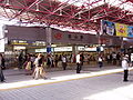
 Platform of Meitetsu Kanayama Station
 -
 Ticket Gate


Platforms
2 island platforms serve 4 tracks.
| 1, 2 | ■ Nagoya Line | for Meitetsu-Nagoya, Meitetsu-Ichinomiya and Meitetsu-Gifu |
| ■ Inuyama Line Hiromi Line |
for Aichi, Inuyama, Shin Unuma and Shin Kani | |
| ■ Tsushima Line Bisai Line |
for Tsushima, Saya and Yatomi | |
| 3, 4 | ■ Nagoya Line Toyokawa Line |
for Jingū-mae, Narumi, Chiryū, Higashi Okazaki, Toyohashi and Toyokawa-inari |
| ■ Nishio Line | for Nishio, and Kira Yoshida | |
| ■ Tokoname Line Airport Line |
for Ōtagawa, Tokoname and Central Japan International Airport | |
| ■ Kowa Line Chita New Line |
for Chita Handa, Kōwa and Utsumi |
Nagoya Municipal Subway Kanayama Station
Kanayama Station 金山駅 | |
|---|---|
| Nagoya Subway station | |
| General information | |
| Location | Kanayama 1-13-11, Naka-ku, Nagoya, Aichi (名古屋市中区金山一丁目13-11) Japan |
| Operated by | Transportation Bureau City of Nagoya |
| Line(s) |
|
| Other information | |
| Station code | M01 E01 |
| History | |
| Opened | 1967 |
| Passengers | |
| 2008 | 71,314 daily |
The subway portion of Kanayama Station was opened on March 30, 1967. Kanayama Station includes a stop on the Meijō Line and Meikō Line. Inside the gates is a small Doutor Coffee shop open every day from 7 am to 9:30 pm.[4]
Lines
- Meijō Line (Station Number: M01)
- for Aichi and Ōzone
- for Aratama-bashi and Nagoya Daigaku (Nagoya University)
- Meikō Line (Station Number: E01)
- for Nagoyakō (Nagoya Port)
Layout
Platforms
| 1 | ■ Meijō Line | for Aratama-bashi, Yagoto, and Aichi |
| 2 | ■ Meikō Line | for Tōkai-dōri and Nagoyakō |
| 3 | ■ Meijō Line | from Nagoyako for Kamimaezu, Aichi, and Ōzone |
| 4 | ■ Meijō Line | from Aratama-bashi for Kamimaezu, Sakae, and Ōzone |
There are four platforms. Platforms 3 and 4, on one physical platform, both serve trains bound for Sakae Station and Ōzone Station. The other physical platform has trains bound for Nagoyakō Station on Platform 2 and trains bound for Aratama-bashi Station on Platform 1.[5]
Adjacent stations
| « | Service | » | ||
|---|---|---|---|---|
| Nagoya Municipal Subway | ||||
| Meijō Line | ||||
| [[Nishi Takakura Station|]] Hibino |
- | [[Higashi Betsuin Station|]] | ||
| Meikō Line | ||||
| Nagoya, Aichi | - | Higashi Betsuin (Meijo Line) | ||
-
 Platforms 1 and 2
 -
 Platforms 2 and 3


See also
 Media related to Kanayama Station (Aichi) at Wikimedia Commons
References
- ^ a b 金山駅 (in Japanese). JR Central. Retrieved 20 November 2010.
{{cite web}}: Unknown parameter|trans_title=ignored (|trans-title=suggested) (help) - ^ バリアフリー (in Japanese). JR Central. Retrieved 20 November 2010.
{{cite web}}: Unknown parameter|trans_title=ignored (|trans-title=suggested) (help) - ^ 金山 (in Japanese). Nagoya Railroad. Retrieved 20 November 2010.
{{cite web}}: Unknown parameter|trans_title=ignored (|trans-title=suggested) (help) - ^ 駅構内店舗 (in Japanese). Transportation Bureau City of Nagoya. Retrieved 21 November 2010.
{{cite web}}: Unknown parameter|trans_title=ignored (|trans-title=suggested) (help) - ^ 駅構内図 (in Japanese). Transportation Bureau City of Nagoya. Retrieved 20 November 2010.
{{cite web}}: Unknown parameter|trans_title=ignored (|trans-title=suggested) (help)
External links
- Nagoya Transportation Bureau's page on Kanayama Subway Station Template:Ja icon
- Asunal Kanayama (shopping and dining) Template:Ja icon
Stations of the Chūō Main Line (Chūō West Line) (JR Central) | ||
|---|---|---|
| ||
Stations of the Nagoya Municipal Subway Meikō Line | ||
|---|---|---|
| |||||||||
(Osaka-Nagoya Line area) | |||||||||
| |||||||||
| Other lines |
| ||||||||
| Cable and Ropeway | |||||||||
| |||||||||
| Terminals | |||||||||
| Miscellaneous |
| ||||||||
- Stations of Central Japan Railway Company
- Chūō Main Line
- Tōkaidō Main Line
- Stations of Nagoya Railroad
- Stations of Nagoya Municipal Subway
- Use dmy dates from February 2011
- Railway stations opened in 1967
- Railway stations opened in 1944
- Railway stations opened in 1962
- Railway stations in Aichi Prefecture
- Railway stations in Nagoya