Kiseljak
Kiseljak | |
|---|---|
 Kiseljak | |
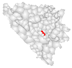
 Location of Kiseljak within Bosnia and Herzegovina. | |
| Country | |
| Government | |
| • Municipality president | Mladen Mišurić-Ramljak (HDZ BiH) |
| Area | |
• Total | 165 km2 (64 sq mi) |
| Population (2013 census) | |
• Total | 21,919 |
| • Density | 133/km2 (340/sq mi) |
| Time zone | UTC+1 (CET) |
| • Summer (DST) | UTC+2 (CEST) |
| Area code | +387 30 wparts = |
| Website | http://www.opcina-kiseljak.org/ |
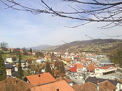
Kiseljak is a small town and municipality in central Bosnia and Herzegovina, located northwest of Sarajevo and south of Zenica. Kiseljak lies in the valley of the Fojnica River, the Lepenica and the Kreševka River, which are a tributary of the Bosna, and it is on the intersection of roads from Visoko, Fojnica, Kreševo and Rakovica. It is administratively part of the Central Bosnia Canton of the Federation of Bosnia and Herzegovina.
Settlements
- Azapovići
- Badnje
- Behrići
- Bilalovac
- Bliznice
- Boljkovići
- Borina
- Brizje
- Brnjaci
- Bukovica
- Buzuci
- Čalikovac
- Čizma
- Čubren
- Datići
- Demići
- Devetaci
- Doci
- Donji Palež
- Draževići
- Dubrave
- Dugo Polje
- Duhri
- Duke
- Gaj
- Gojakovac
- Gomionica
- Gornji Palež
- Gradac
- Grahovci
- Gromiljak
- Gunjače
- Hadrovci
- Han Ploča
- Hercezi
- Homolj
- Hrastovi
- Ivica
- Jehovac
- Katunište
- Kazagići
- Kiseljak
- Kotačala
- Kovači
- Krčevine
- Križići
- Kuliješ
- Lug
- Ljetovik
- Mahala Gomionica
- Mahala Višnjica
- Male Sotnice
- Markovići
- Maslinovići
- Medovci
- Medovići
- Miroševići
- Mrakovi
- Odrače
- Paretak
- Pariževići
- Pobrđe Milodraž
- Pobrđe Orahovo
- Podastinje
- Podastinjsko Brdo
- Polje Višnjica
- Potkraj
- Radanovići
- Radeljevići
- Rauševac
- Rotilj
- Solakovići
- Stojkovići
- Svinjarevo
- Šahinovići
- Toplica
- Tulica
- Velike Sotnice
- Višnjica
- Zabrđe
- Završje
- Žeželovo
Demographics
1971
18,335 total
- Croats - 10,389 (56.66%)
- Bosniaks - 6,822 (37.20%)
- Serbs - 924 (5.03%)
- Yugoslavs - 55 (0.29%)
- others - 145 (0.82%)
1991
In 1991 the population of the Kiseljak municipality (164 km²) was 24,426, of which 51.61% were Croats, 40.92% Bosniaks, 3.11% Serbs, 2.48% Yugoslavs and 1.88% others. The town itself had a population of 6,598, of which 60% Croats, 29% Bosniaks, 3% Serbs, 5% Yugoslavs and 4% others.[1].
External links
43°57′N 18°05′E / 43.950°N 18.083°E

