
Maçka
Maçka | |
|---|---|
District and municipality | |
 | |
 Map showing Maçka District in Trabzon Province | |
 Maçka Location in Turkey | |
| Coordinates: 40°48′43″N 39°36′47″E / 40.81194°N 39.61306°E | |
| Country | Turkey |
| Province | Trabzon |
| Government | |
| • Mayor | Koray Koçhan (AKP) |
| Area | 925 km2 (357 sq mi) |
| Elevation | 470 m (1,540 ft) |
| Population (2022)[1] | 24,709 |
| • Density | 27/km2 (69/sq mi) |
| Time zone | UTC+3 (TRT) |
| Postal code | 61750 |
| Area code | 0462 |
| Climate | Cfb |
| Website | www |
Maçka (Greek: Ματζούκα, romanized: Matzoúka, the "club"; Laz: მაჩხა Maçxa) is a municipality and district of Trabzon Province, Turkey.[2] Its area is 925 km2,[3] and its population is 24,709 (2022).[1] The name derives from the medieval Greek Matzouka, which was one of the provinces of the Empire of Trebizond. In Ottoman times, the area formed the nahiye of Maçuka. The Greek Orthodox Sumela Monastery is located in the district.
Composition[edit]
There are 67 neighbourhoods in Maçka District:[4]
- Akarsu
- Akmescit
- Alaçam
- Alataş
- Altındere
- Anayurt
- Ardıçlıyayla
- Armağan
- Atasu
- Bağışlı
- Bahçekaya
- Bakımlı
- Bakırcılar
- Barışlı
- Başar
- Çamlıdüz
- Çatak
- Çayırlar
- Çeşmeler
- Çıralı
- Coşandere
- Dikkaya
- Erginköy
- Esiroğlu
- Fatih
- Gayretli
- Günay
- Güney
- Gürgenağaç
- Güzelce
- Güzelyayla
- Hamsiköy
- Hızarlı
- Kapıköy
- Kaynarca
- Kırantaş
- Kiremitli
- Konak
- Köprüyanı
- Kozağaç
- Kuşçu
- Mataracı
- Merkez
- Ocaklı
- Oğulağaç
- Öğütlü
- Ormaniçi
- Ormanüstü
- Örnekalan
- Ortaköy
- Reşadiye
- Sevinç
- Şimşirli
- Sındıran
- Sukenarı
- Temelli
- Üçgedik
- Yaylabaşı
- Yazılıtaş
- Yazlık
- Yeni Atasu
- Yeniköy
- Yeşiltepe Mahallesi
- Yeşilyurt
- Yukarıköy
- Yüzüncüyıl
- Zaferli
Gallery[edit]
-
 City center of Maçka
 -
 Sumela Monastery in the Pontic Mountains
 -
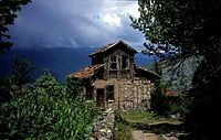 A traditional rural Pontic house in Livera (Yazlık)
 -
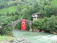 Hamsiköy
 -
 Yazlık


Twin towns – Sister cities[edit]
Maçka is twinned with:
References[edit]
- ^ a b "Address-based population registration system (ADNKS) results dated 31 December 2022, Favorite Reports" (XLS). TÜİK. Retrieved 19 September 2023.
- ^ Büyükşehir İlçe Belediyesi, Turkey Civil Administration Departments Inventory. Retrieved 19 September 2023.
- ^ "İl ve İlçe Yüz ölçümleri". General Directorate of Mapping. Retrieved 19 September 2023.
- ^ Mahalle, Turkey Civil Administration Departments Inventory. Retrieved 19 September 2023.
- ^ Karesi ve Maçka kardeş şehir oldu (in Turkish)
External links[edit]
Wikimedia Commons has media related to Maçka.
- District governor's official website (in Turkish)
- Matsouka (Maçka)
- Maçka (in Turkish)
- Maçka haritası (in Turkish)
Maçka in Trabzon Province of Turkey | |||||||||||||||||||||||||||
|---|---|---|---|---|---|---|---|---|---|---|---|---|---|---|---|---|---|---|---|---|---|---|---|---|---|---|---|
| Districts |   | ||||||||||||||||||||||||||
|
Metropolitan municipalities are bolded. | |||||||||||||||||||||||||||
| International | |
|---|---|
| National | |
This article about a Black Sea Region of Turkey location is a stub. You can help Wikipedia by expanding it. |