
Prozor-Rama
Prozor-Rama
Прозор-Рама | |
|---|---|
Town and municipality | |
 Panoramic view | |
 Location of Prozor-Rama within Bosnia and Herzegovina. | |
| Country | Bosnia and Herzegovina |
| Entity | Federation of Bosnia and Herzegovina |
| Government | |
| • Municipality president | Jozo Ivančević (HDZ 1990) |
| Area | |
| • Total | 477 km2 (184 sq mi) |
| Population (2013 census) | |
| • Total | 14,280 |
| Time zone | UTC+1 (CET) |
| • Summer (DST) | UTC+2 (CEST) |
| Area code | +387 36 |
| Website | Official site |
Prozor-Rama is a town and municipality located in Herzegovina-Neretva Canton of the Federation of Bosnia and Herzegovina, an entity of Bosnia and Herzegovina. Also, Ramsko jezero (Rama Lake) is located near the town.
History
In the Middle Ages, the King of Hungary held the title of King of Rama named after this region.
-
 Seferov-Han in the Rama valley, 1897
 -
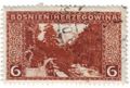 Rama valley on 1906 Austro-Hungarian stamp
 -
 Italians and Chetniks in Prozor in 1943 ("Operation Alfa")
 -
 Ustasha in Prozor, 1943
 -
 Partisans in Prozor, 1943
_(14758823696).jpg)


Demographics

2013
14,280 total
Sports
The area is home to the football club NK Rama, and basketball club HKK Rama.
External links
![]() Media related to Prozor-Rama Municipality at Wikimedia Commons
Media related to Prozor-Rama Municipality at Wikimedia Commons
- Official website of municipality Prozor - Rama
- Ramski Vjesnik - local news portal
- rama-prozor.info
- prozor-x.com
Notable people
- Diva Grabovčeva
- Marko Bošnjak - Singer
References
Municipalities of the Herzegovina-Neretva Canton | ||
|---|---|---|

43°49′12″N 17°36′36″E / 43.82000°N 17.61000°E
This Herzegovina-Neretva Canton geography article is a stub. You can help Wikipedia by expanding it. |