
Taal, Batangas
Taal | |
|---|---|
| Municipality of Taal | |
 Minor Basilica of Saint Martin of Tours | |
 Seal | |
 Map of Batangas with Taal highlighted | |
OpenStreetMap  | |
.svg) Taal Location within the Philippines | |
| Coordinates: 13°53′N 120°56′E / 13.88°N 120.93°E | |
| Country | Philippines |
| Region | Calabarzon |
| Province | Batangas |
| District | 1st district |
| Founded | April 26, 1572 |
| Barangays | 42 (see Barangays) |
| Government | |
| • Type | Sangguniang Bayan |
| • Mayor | Fulgencio I. Mercado |
| • Vice Mayor | Michael Rey A. Villano |
| • Representative | Joseph Eric R. Buhain |
| • Municipal Council | Members |
| • Electorate | 38,386 voters (2022) |
| Area | |
| • Total | 29.76 km2 (11.49 sq mi) |
| Elevation | 63 m (207 ft) |
| Highest elevation | 194 m (636 ft) |
| Lowest elevation | 0 m (0 ft) |
| Population (2020 census)[3] | |
| • Total | 61,460 |
| • Density | 2,100/km2 (5,300/sq mi) |
| • Households | 14,977 |
| Economy | |
| • Income class | 3rd municipal income class |
| • Poverty incidence | 9.45 |
| • Revenue | ₱ 185 million (2020) |
| • Assets | ₱ 364.6 million (2020), 168.8 million (2012) |
| • Expenditure | ₱ 142.2 million (2020) |
| • Liabilities | ₱ 59.95 million (2020) |
| Service provider | |
| • Electricity | Batangas 1 Electric Cooperative (BATELEC 1) |
| Time zone | UTC+8 (PST) |
| ZIP code | 4208 |
| PSGC | |
| IDD : area code | +63 (0)43 |
| Native languages | Tagalog |
Taal [ta'ʔal], officially the Municipality of Taal (Tagalog: Bayan ng Taal), is a 3rd class municipality in the province of Batangas, Philippines. According to the 2020 census, it has a population of 61,460 people.[3]
Taal is famous for its old ancestral houses, one particular ancestral house (now a museum) where Marcela Coronel Mariño de Agoncillo grew up in Taal, Batangas built in the 1770s by her grandparents, Don Andres Sauza Mariño and Doña Eugenia Diokno Mariño. Its poblacion (town proper) is designated as a National Historical Landmark.[5] The municipality is known as the balisong and barong tagalog capital of the Philippines. The town is home to hundreds of heritage structures dating from the Spanish colonial period. Scholars have been pushing for its inclusion in the UNESCO World Heritage List.
Etymology
The name "Taal" may have come from:[6]
- The archaic Tagalog word taal, possibly meaning pure or unadulterated;
- The Tagalog word taad, which refers to sugarcane cutting used in planting;
- A wild palm tree called tal-an or taal-an or possibly after the tala palm (Borassus flabellifer), hence the name tala-an meaning “the place where the “tala grows”; and
- The ipil tree (Intsia bijuga), which is also known as taal in some areas of the Philippines.
History

The town of Taal was founded by Augustinian friars in 1572.[7] In 1575, the town transferred later to the edge of Domingo Lake (now Taal Lake) in 1575. In 1732, it became the provincial capital of Batangas. In 1754, Taal Volcano erupted, endangering the town of Taal which stood at present-day San Nicolas. Threatened by the new danger, the townspeople, together with the Augustinian Francisco Benchucillo, sought refuge in the sanctuary of Caysasay.[8][9] The provincial capital was also transferred to the then-town of Batangas in the same year.[10]
Territorial changes
Taal used to encompass a much more extensive area. In 1596, the former barrio of Bauan was established as a parish, effectively separating it from Taal.[11]
Following the 1754 Taal Volcano eruption, the northern shoreline of Taal Lake that was previously part of Tanauan were annexed to Taal as Tanauan transferred from the lake's northwestern Tanauan Bay to Sala, its present-day barangay. It later became part of Talisay upon its establishment in 1869.[9]
In 1861, the southern parts of Taal were separated to form the new municipality of San Luis.[12] A year later, the northern and western parts of Taal were also separated to form the municipality of Lemery, which also consists the present-day Agoncillo.
In 1903, San Luis and Lemery were returned to Taal; San Luis's poblacion was reverted to its old name Balibago.[13] In 1904, the western Tanauan barrios of Balaquilong (Balakilong), Bayuyungan, Binirayan (Berinayan), Bugaan, and San Gabriel were annexed to Taal by virtue of Act No. 1244;[14] these barrios would eventually be returned to Talisay and become barangays of present-day Laurel.[15][16] Lemery and San Luis were once again separated from Taal and reconstituted as independent municipalities in 1906 and in 1918, respectively.[12][17]
In 1955, the northern barrios of San Nicolas, Gipit, Bangin, Pansipit, Calangay, Sinturisan, Talang, Abilo, Balete, Bancora, Saimsim, Maabud, Mulawin, Tambo, Calumala, Alasas, Calawit, and Pulangbato were separated from Taal to form the new municipality of San Nicolas.[18] In 1961, the eastern barrios of Sambat, Sinipian, Bihis, Calayaan, Irukan and Cutang Cawayan were separated from Taal to form the new municipality of Santa Teresita.[19]
Geography
According to the Philippine Statistics Authority, the municipality has a land area of 29.76 square kilometers (11.49 sq mi) [20] constituting 0.95% of the 3,119.75-square-kilometer (1,204.54 sq mi) total area of Batangas.
It covers an area of 270 square kilometers (100 sq mi) and is drained by Pansipit River down into Balayan Bay. Pansipit is one of the major ecological highways that allow migration of two fish species: maliputo (Cranx ignobilis) and muslo (Cranx marginalis) which are unique to lake Taal. Adult fish migrate to the sea from Taal Lake via Pansipit River and Palanas River in Lemery. The tawilis (Harengula tawilis) is a freshwater sardine also endemic to Taal Lake.
Climate
| Climate data for Taal, Batangas | |||||||||||||
|---|---|---|---|---|---|---|---|---|---|---|---|---|---|
| Month | Jan | Feb | Mar | Apr | May | Jun | Jul | Aug | Sep | Oct | Nov | Dec | Year |
| Mean daily maximum °C (°F) | 28 (82) |
30 (86) |
31 (88) |
33 (91) |
32 (90) |
30 (86) |
29 (84) |
29 (84) |
29 (84) |
29 (84) |
29 (84) |
28 (82) |
30 (85) |
| Mean daily minimum °C (°F) | 20 (68) |
20 (68) |
20 (68) |
22 (72) |
24 (75) |
24 (75) |
24 (75) |
24 (75) |
24 (75) |
23 (73) |
22 (72) |
21 (70) |
22 (72) |
| Average precipitation mm (inches) | 11 (0.4) |
13 (0.5) |
14 (0.6) |
32 (1.3) |
101 (4.0) |
142 (5.6) |
208 (8.2) |
187 (7.4) |
175 (6.9) |
131 (5.2) |
68 (2.7) |
39 (1.5) |
1,121 (44.3) |
| Average rainy days | 5.2 | 5.0 | 7.4 | 11.5 | 19.8 | 23.5 | 27.0 | 25.9 | 25.2 | 23.2 | 15.5 | 8.3 | 197.5 |
| Source: Meteoblue[21] | |||||||||||||
Taal has two seasons: dry from November to April, and wet during the rest of the year. The lowest minimum temperature does not drop below 20 °C (68 °F) while the highest maximum temperature of 34.5 °C (94.1 °F) occurs from March to July of each year.
Barangays
Taal is politically subdivided into 42 barangays.[22] Each barangay consists of puroks and some have sitios.
| PSGC | Barangay | Population | ±% p.a. | |||
|---|---|---|---|---|---|---|
| 2020[3] | 2010[23] | |||||
| 041029001 | Apacay | 3.4% | 2,117 | 1,955 | 0.80% | |
| 041029002 | Balisong | 5.0% | 3,097 | 2,839 | 0.87% | |
| 041029003 | Bihis | 1.1% | 702 | 572 | 2.07% | |
| 041029004 | Bolbok | 1.8% | 1,131 | 1,027 | 0.97% | |
| 041029005 | Buli | 6.6% | 4,033 | 3,460 | 1.54% | |
| 041029006 | Butong | 8.0% | 4,926 | 4,627 | 0.63% | |
| 041029007 | Carasuche | 1.2% | 766 | 669 | 1.36% | |
| 041029008 | Cawit | 3.5% | 2,150 | 1,843 | 1.55% | |
| 041029009 | Caysasay | 1.0% | 610 | 577 | 0.56% | |
| 041029010 | Cubamba | 1.5% | 904 | 772 | 1.59% | |
| 041029011 | Cultihan | 3.2% | 1,948 | 1,812 | 0.73% | |
| 041029012 | Gahol | 2.0% | 1,202 | 1,060 | 1.26% | |
| 041029013 | Halang | 2.3% | 1,410 | 1,250 | 1.21% | |
| 041029014 | Iba | 4.8% | 2,962 | 2,633 | 1.18% | |
| 041029015 | Ilog | 1.9% | 1,183 | 1,113 | 0.61% | |
| 041029016 | Imamawo | 1.1% | 700 | 615 | 1.30% | |
| 041029017 | Ipil | 1.3% | 796 | 712 | 1.12% | |
| 041029018 | Luntal | 2.1% | 1,315 | 1,186 | 1.04% | |
| 041029019 | Mahabang Lodlod | 2.0% | 1,218 | 1,089 | 1.13% | |
| 041029020 | Niogan | 0.7% | 411 | 341 | 1.88% | |
| 041029021 | Pansol | 1.4% | 881 | 819 | 0.73% | |
| 041029022 | Poblacion 11 | 0.5% | 294 | 355 | −1.87% | |
| 041029023 | Poblacion 1 | 0.7% | 419 | 401 | 0.44% | |
| 041029024 | Poblacion 10 | 1.1% | 700 | 760 | −0.82% | |
| 041029025 | Poblacion 12 | 0.5% | 283 | 249 | 1.29% | |
| 041029026 | Poblacion 2 | 0.5% | 280 | 323 | −1.42% | |
| 041029027 | Poblacion 3 | 1.2% | 760 | 918 | −1.87% | |
| 041029028 | Poblacion 4 | 0.5% | 284 | 395 | −3.24% | |
| 041029029 | Poblacion 5 | 2.9% | 1,805 | 1,710 | 0.54% | |
| 041029030 | Poblacion 6 | 1.4% | 858 | 828 | 0.36% | |
| 041029031 | Poblacion 7 | 0.3% | 158 | 258 | −4.78% | |
| 041029032 | Poblacion 8 | 1.7% | 1,036 | 761 | 3.13% | |
| 041029033 | Poblacion 9 | 1.6% | 977 | 925 | 0.55% | |
| 041029034 | Pook | 2.1% | 1,316 | 1,077 | 2.02% | |
| 041029044 | Seiran | 4.9% | 2,995 | 2,678 | 1.12% | |
| 041029045 | Laguile | 4.5% | 2,790 | 2,544 | 0.93% | |
| 041029046 | Latag | 1.6% | 960 | 950 | 0.10% | |
| 041029047 | Tierra Alta | 1.6% | 963 | 893 | 0.76% | |
| 041029048 | Tulo | 4.4% | 2,717 | 2,370 | 1.38% | |
| 041029049 | Tatlong Maria | 2.1% | 1,287 | 1,159 | 1.05% | |
| 041029050 | Poblacion 13 | 0.8% | 477 | 449 | 0.61% | |
| 041029051 | Poblacion 14 | 0.8% | 506 | 529 | −0.44% | |
| Total | 61,460 | 51,503 | 1.78% | |||
Demographics
| Year | Pop. | ±% p.a. |
|---|---|---|
| 1903 | 17,525 | — |
| 1918 | 21,155 | +1.26% |
| 1939 | 23,004 | +0.40% |
| 1948 | 26,044 | +1.39% |
| 1960 | 23,000 | −1.03% |
| 1970 | 24,907 | +0.80% |
| 1975 | 26,705 | +1.41% |
| 1980 | 29,699 | +2.15% |
| 1990 | 34,925 | +1.63% |
| 1995 | 38,722 | +1.95% |
| 2000 | 43,455 | +2.50% |
| 2007 | 51,459 | +2.36% |
| 2010 | 51,503 | +0.03% |
| 2015 | 56,327 | +1.72% |
| 2020 | 61,460 | +1.73% |
| Source: Philippine Statistics Authority[24][23][25][26] | ||
In the 2020 census, Taal had a population of 61,460.[3] The population density was 2,100 inhabitants per square kilometer (5,400/sq mi).
The first census in 1903 recorded a total population of 17,525. The 2007 population was 51,459 growing at 2.44% annually over the previous 7 years, with 7,961 households. By 2010, the population slightly increased to 51,503.
Economy
(2018-07-30).jpg)
Poverty incidence of Taal
1
2
3
4
5
6
7
8
9
10
2006
10.00 2009
4.14 2012
6.96 2015
5.45 2018
8.84 2021
9.45 Source: Philippine Statistics Authority[27][28][29][30][31][32][33][34] |
Cultural events
- The EL PASUBAT Festival, celebrated annually during the month of April, is the conglomeration of the trademarks of Taal. "EL PASUBAT" stands for Empanada, Longganisa, Panutsa, Suman, Balisong, barong tagalog, Tapa, Tamales, Tawilis, Tulingan — the delicacies and crafts that Taal is known for.[35]
- The Feast of St. Martin of Tours is held November 11 every year. Celebrations are in the form of prayer, hymns, declamation, flower offerings and big religious processions. Most families celebrate with food and drinks for visitors thereafter.
- The Feast of Our Lady of Caysasay, the well-known miraculous image of the Immaculate Conception, is celebrated every December 8. A joint town fiesta celebrated on December 9 honoring both Our Lady of Caysasay and Saint Martin of Tours.
- Lua is a traditional declamation in the vernacular recited by a maiden to honor the Virgin Mary or a boy in praise of a male saint like Saint Martin of Tours. In the procession, young girls and ladies in their pretty gowns make up the hila (pull), so called because they are supposed to pull the cord of lights originating from the Virgin's karosa (procession carriage) bedecked with flowers.
Local products and delicacies

Since the Spanish period, the people of Taal lived by farming and commerce. The main produce are cotton, cacao and sugar which are made through the use of crude sugar mill called trapeche. Weaving and embroidery of barong and camisa (blouses) made from piña are popular home industries. Local embroidery businesses later expanded their products to include curtains, piano covers, pillowcases, tablecloth, table napkins and bed covers, adding more fame already earned by Taal embroidery.
Other products produced in the town are balisong (butterfly knife) and various food treats such as the panocha (peanut brittle candy) and suman salehiya (a sweet suman), tapa (cured pork) and the local longganisa, all of which are available at the public market. Popular Taal dishes include adobo sa dilaw (yellow adobo) and sinaing na tulingan (bonita fish soup).
Notable personalities

Philippine Revolution
- Gliceria de Villavicencio was named as the “godmother of the revolutionary forces” by Gen. Emilio Aguinaldo. She supported the revolution against the Spaniards, and later the Americans inflamed by the death of her husband, Eulalio Villavicencio, in February 1898.
- Felipe Agoncillo is a revolutionary hero, statesman, and diplomat Philippine Republic to the United States and to the Treaty of Paris in 1898.
- Marcela Agoncillo is best known as "The Mother of the Philippine Flag" for being the maker of the present flag of the Philippines, first unfurled at the declaration of Philippine Independence on June 12, 1898, in Kawit, Cavite.
- Vicente Ilustre was associated with other Filipinos like José Rizal, Marcelo H. Del Pilar, Galicano Apacible, and others in Spain. He became a member of the Philippine Commission under Governor-General Francis Burton Harrison where he served as president of the committee for Mindanao and Sulu. Thereafter, he became a Senator in the First Senate of the Philippines. He was also instrumental in the installation of public light and water utilities in Taal.
- Ananías Diokno was the only Tagalog general to lead a full-scale military expedition to the Visayas against the Spanish forces. He became governor of Capiz.
- Galicano Apacible, was a co-founder of La Solidaridad with his cousin José Rizal. He later co-founded the Nacionalista Party and served as Governor of Batangas, assemblyman, and agriculture and natural resources secretary.
Modern Taaleños
- Ramón Diokno, Senator and Supreme Court Justice
- Jose W. Diokno, Senator and Secretary of Justice. The Sangguniang Bayan meets at the Sen. Jose W. Diokno Legislative Hall at the Municipal Hall.
- Father Fernando Suarez, a Catholic priest known worldwide for faith healing, was born here in 1967.
- Benjamin Diokno - Secretary of Budget and Management 1998–2001, 2016–2019; Governor of Bangko Sentral ng Pilipinas 2019–2022; Secretary of Finance 2022-present
Gallery
-

-

-
 Municipal hall
 -
 Felipe Agoncillo ancestral house
 -
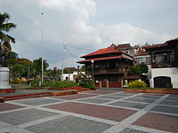 Taal Plaza
 -
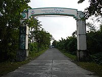
 Our Lady of Caysasay Academy gate
 -
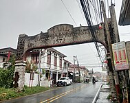 Arch at Taal town proper
 -
 Welcome arch from San Nicolas
 -
 San Lorenzo Ruiz Steps
 -
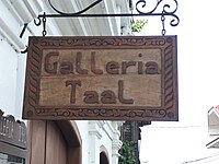 Galleria Taal
 -
 Ancestral houses
(2018-07-30).jpg)
_2024-03-27.jpg)
(2018-07-30).jpg)


.jpg)

.jpg)
See also
- Basilica de San Martin de Tours (Taal) – the biggest Catholic Basilica Church in the Far East
- Our Lady of Caysasay
- Our Lady of Caysasay Academy
References
- ^ Municipality of Taal | (DILG)
- ^ "2015 Census of Population, Report No. 3 – Population, Land Area, and Population Density" (PDF). Philippine Statistics Authority. Quezon City, Philippines. August 2016. ISSN 0117-1453. Archived (PDF) from the original on May 25, 2021. Retrieved July 16, 2021.
- ^ a b c d Census of Population (2020). "Region IV-A (Calabarzon)". Total Population by Province, City, Municipality and Barangay. Philippine Statistics Authority. Retrieved July 8, 2021.
- ^ "PSA Releases the 2021 City and Municipal Level Poverty Estimates". Philippine Statistics Authority. April 2, 2024. Retrieved April 28, 2024.
- ^ NHCP Historic Preservation Division. "Portion of the Town of Taal". National Registry of Historic Sites & Structures in the Philippines. Retrieved on July 3, 2013.
- ^ Buhay Batangas. "4 Different Versions about How Taal Got Its Name". Batangas History, Culture and Folklore. Retrieved March 2, 2018.
- ^ Worcester, Dean C. (April 1912). "Taal Volcano and Its Recent Destructive Eruption". The National Geographic Magazine.
- ^ Galende, O.S.A, Pedro G.; Javellana, S.J, Rene B. (1993). Great Churches of the Philippines. pp. 46–47.
- ^ a b Hargrove, Thomas (1991). The Mysteries of Taal: A Philippine volcano and lake, her sea life and lost towns. Manila: Bookmark Publishing. pp. 24–34, 145–148. ISBN 9715690467.
- ^ "Brief History". Official Website of the Province of Batangas. Retrieved July 5, 2023.
- ^ "History of Bauan". Municipality of Bauan. Retrieved July 6, 2023.
- ^ a b "History". San Luis Batangas. Retrieved August 9, 2021.
- ^ Act No. 708 (March 28, 1903), An Act Reducing Thirteen of the Municipalities in the Province of Batangas to Five, retrieved July 5, 2023 (Full text via Senate of the Philippines Legislative Digital Resources Bureau.)
- ^ Act No. 1244 (October 7, 1904), An Act Annexing the Barrios of Bayuyungan, Bugaan, Balaquilong, San Gabriel, and Binirayan, Now a Part of the Municipality of Tanauan, Province of Batangas, to the Municipality of Taal, in the Same Province, retrieved July 5, 2023 (Full text via Senate of the Philippines Legislative Digital Resources Bureau.)
- ^ Act No. 1514 (July 23, 1906), An Act Increasing the Number of Municipalities in the Province of Batangas From Fifteen to Sixteen, by Separating From Tanauan the Former Municipality of Talisay, Reconstituting the Latter as a Municipality, and Giving to Each the Territory Which It Comprised Prior to the Passage of Act Numbered Seven Hundred and Eight, retrieved July 5, 2023 (Full text via Senate of the Philippines Legislative Digital Resources Bureau.)
- ^ Republic Act No. 5689 (June 21, 1969), An Act Creating the Municipality of Laurel in the Province of Batangas, retrieved July 3, 2023 (Full text via The Corpus Juris.)
- ^ Act No. 1549 (October 25, 1906), An Act Increasing the Number of Municipalities in the Province of Batangas From Sixteen to Seventeen, by Separating From Taal the Former Municipality of Lemery, Reconstituting the Latter as a Municipality, and Giving the Same the Territory Which It Comprised Prior to the Passage of Act Numbered Seven Hundred and Eight., retrieved July 5, 2023 (Full text via Senate of the Philippines Legislative Digital Resources Bureau.)
- ^ Republic Act No. 1229 (June 1, 1955), An Act Creating the Municipality of San Nicolas, Province of Batangas, retrieved July 5, 2023 (Full text via The Corpus Juris.)
- ^ Executive Order No. 454, s. 1961 (December 28, 1961), Creating the Municipality of Sta. Teresita in the Province of Batangas, retrieved July 5, 2023 (Full text via the Official Gazette of the Republic of the Philippines.)
- ^ "Province:". PSGC Interactive. Quezon City, Philippines: Philippine Statistics Authority. Retrieved November 12, 2016.
- ^ "Taal: Average Temperatures and Rainfall". Meteoblue. Retrieved May 5, 2020.
- ^ "Municipal: Taal, Batangas". PSGC Interactive. Quezon City, Philippines: Philippine Statistics Authority. Retrieved January 8, 2016.
- ^ a b Census of Population and Housing (2010). "Region IV-A (Calabarzon)" (PDF). Total Population by Province, City, Municipality and Barangay. National Statistics Office. Retrieved June 29, 2016.
- ^ Census of Population (2015). "Region IV-A (Calabarzon)". Total Population by Province, City, Municipality and Barangay. Philippine Statistics Authority. Retrieved June 20, 2016.
- ^ Censuses of Population (1903–2007). "Region IV-A (Calabarzon)". Table 1. Population Enumerated in Various Censuses by Province/Highly Urbanized City: 1903 to 2007. National Statistics Office.
- ^ "Province of". Municipality Population Data. Local Water Utilities Administration Research Division. Retrieved December 17, 2016.
- ^ "Poverty incidence (PI):". Philippine Statistics Authority. Retrieved December 28, 2020.
- ^ "Estimation of Local Poverty in the Philippines" (PDF). Philippine Statistics Authority. November 29, 2005.
- ^ "2003 City and Municipal Level Poverty Estimates" (PDF). Philippine Statistics Authority. March 23, 2009.
- ^ "City and Municipal Level Poverty Estimates; 2006 and 2009" (PDF). Philippine Statistics Authority. August 3, 2012.
- ^ "2012 Municipal and City Level Poverty Estimates" (PDF). Philippine Statistics Authority. May 31, 2016.
- ^ "Municipal and City Level Small Area Poverty Estimates; 2009, 2012 and 2015". Philippine Statistics Authority. July 10, 2019.
- ^ "PSA Releases the 2018 Municipal and City Level Poverty Estimates". Philippine Statistics Authority. December 15, 2021. Retrieved January 22, 2022.
- ^ "PSA Releases the 2021 City and Municipal Level Poverty Estimates". Philippine Statistics Authority. April 2, 2024. Retrieved April 28, 2024.
- ^ "El Pasubat". Taal Tourism Office. Archived from the original on June 29, 2020. Retrieved May 16, 2014.
External links
Places adjacent to Taal, Batangas | |
|---|---|
| Component cities | |
|---|---|
| Municipalities | |
| International | |
|---|---|
| National | |