
Mumbra
Mumbra | |
|---|---|
suburb | |
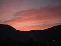
 Sunrise view of Mumbra | |
 Mumbra Location of Mumbra in Maharashtra, India | |
| Coordinates: 19°10′48″N 73°01′21″E / 19.18000°N 73.02250°E | |
| Country | India |
| State | Maharashtra |
| District | Thane |
| Metro | Mumbai |
| Government | |
| • Type | Municipal Corporation |
| • Body | Thane Municipal Corporation |
| Area | |
| • Total | 13.97 km2 (5.39 sq mi) |
| Population (2023) | |
| • Total | 500,000 |
| • Density | 36,000/km2 (93,000/sq mi) |
| Time zone | UTC+5:30 (IST) |
| PIN code | 400 612 |
| Telephone code | (022) |
| Vehicle registration | MH-04 Thane city |
| Lok Sabha constituency | Kalyan |
| Vidhan Sabha constituency | Mumbra-Kalwa |
| Website | http://mumbra.org/ |
Mumbra is a town in Thane district in Western India in the state of Maharashtra, a Mumbai suburb within the Mumbai Metropolitan Region. It is administered by Thane Municipal Corporation.
History[edit]
Mumbra was a flourishing shipbuilding center in early times.
Much of the land around Mumbra was agricultural land until 1975. Between 1968 and 1975, Mumbai experienced significant population growth and greater population density. Then, about 1975, Mumbra's agricultural land was urbanized. This signaled an expansion of the greater Mumbai area, which realized significant population growth in the 1980s.[1] Wafa Hill's "A, B, C" was one of the first planned Thane Municipal Corporation (TMC) approved buildings developed in the 1990s. Which lead the foundation for urbanization in Mumbra.[2]
In 1991 there were about 44,000 people.[3] After the riots of 1992 many Muslims fled Mumbai and settled in Mumbra; 10 Sq mile land was allotted by state Government under custody of state waqf board for resettlement of fled Muslims of different part of Mumbai. It is India's largest Muslim locality also known by India's largest Muslim Ghetto.[4] Non-Governmental Organization(NGO) who is working for Mumbra area is Mumbra Welfare Association registered under Registered in Central Government of India (U88900MH2024NPL422145) of Section 8 Company of Ministry of Corporate Affairs (MCA). Registered in NGO Darpan maintained by NITI Aayog. Certified under section 12A and Section 80G
Demographics[edit]
The population of Mumbra was 5 lakhs as of 2023.[3] More than 85% of Mumbra's residents are Muslim.[5]
Transport[edit]
Bus service is available through the Thane Municipal Transport (TMT) and Navi Mumbai Municipal Transport (NMMT).[6]
Rail service is available at the Mumbra railway station on Central line, also called as mainline.[7] Mumbra is 29 kilometres (18 mi) from the Mumbai airport.[8]
The main source of Transport in Mumbra is Auto-Rickshaw. Mumbra didn't have any bus starting from Mumbra railway station and hence Auto-Rickshaws was the only possible conveyance.[citation needed]
But now, TMT Thane Municipal Transport runs bus service starting from Mumbra Railway Station to Bharat gears company.
State transport (MSRTC) operate regular bus service between Panvel, Bhiwandi, and Shil Phata.[citation needed]
Gallery[edit]
Mumbra is known for its green lavish mountains and waterfalls enhancing the beauty of the city.[citation needed]
-
 The Green Side
 -
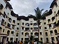 Wafa Hills, A-B-C society (Iconic Structure)
 -
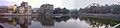 Kausa Talao at Mumbra
 -
 A peak
 -
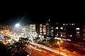 Amrut Nagar at Night
 -
 Ship Building Yard
 -
 Mumbra sunset
 -
 Mumbra sunset


References[edit]
- ^ Metropolitan planning and management in the developing world: spatial decentralization policy in Bombay and Cairo. United Nations Centre for Human Settlements (UN-HABITAT). 1993. pp. 39–40. ISBN 9211312337. OCLC 32406987.
- ^ Mumbracity.com online portal on Mumbra
- ^ a b "Thane building collapse: Mumbra tragedy a fallout of illegal construction boom". Indian Express. 9 April 2013. Retrieved 9 April 2013.
- ^ Peer, Basharat (10 June 2016). "In India's largest Muslim ghetto". The Hindu. Retrieved 5 July 2022.
- ^ Halarnkar, Samar (24 November 2011). "Lesson from Mumbra". Hindustan Times.
- ^ "Direct Mumbra-Vashi bus service from today". The Times of India. 5 October 2008. Archived from the original on 29 June 2013. Retrieved 8 April 2013.
- ^ "Mumbra Local Station Information". Mumba Life Life. Retrieved 9 April 2013.
- ^ "Distance from Mumbra to domestic airport at Mumbai". Distances Between. Retrieved 9 April 2013.