
Safranbolu
| UNESCO World Heritage Site | |
|---|---|
 | |
| Criteria | Cultural: ii, iv, v |
| Reference | 614 |
| Inscription | 1994 (18th Session) |
Safranbolu | |
|---|---|
Dictrict | |
 A street in historical Shoe-makers market of Safranbolu | |
 Location of Safranbolu within Turkey. | |
| Country | |
| Region | Black Sea |
| Province | Karabük |
| Area | |
| • Dictrict | 1,000 km2 (400 sq mi) |
| Elevation | 485 m (1,591 ft) |
| Population (2000)[1] | |
| • Dictrict | 47,257 |
| • Density | 47.26/km2 (122.4/sq mi) |
| • Urban | 31,697 |
| Time zone | UTC+2 (EET) |
| • Summer (DST) | UTC+3 (EEST) |
| Postal code | 78xxx |
| Area code | 370 |
| Licence plate | 78 |
| Website | www.safranbolu.bel.tr |
Safranbolu is a town and district of Karabük Province in the Black Sea region of Turkey. Its location can be roughly described as about two hundred kilometers north of Ankara and about a hundred kilometers south of the Black Sea coast, or more precisely as about 9 kilometers north of the city of Karabük. Former Turkish names of her were Zalifre and Taraklıborlu. According to the 2000 census, population of the district is 47,257 of which 31,697 live in the town of Safranbolu.[1][2] The district covers an area of 1,000 km2 (386 sq mi),[3] and the town lies at an elevation of 485 m (1,591 ft).
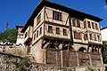
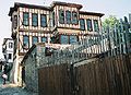
The Old Town preserves many old buildings, with 1008 registered historical artifacts. These are: 1 private museum, 25 mosques, 5 tombs, 8 historical fountains, 5 Turkish baths, 3 caravanserais, 1 historical clock tower, 1 sundial and hundreds of houses and mansions. Also there are mounds of ancient settlements, rock tombs and historical bridges. The Old Town is situated in a deep ravine in a fairly dry area in the rain shadow of the mountains. The New Town can be found on the plateau about two kilometers west of the Old Town.
The name of the town derives from saffron, since Safranbolu was a trading place and a center for growing saffron.Today saffron is still alive at the village of Davutobası which is 22 km.east of Safranbolu and probably one of the best quality saffron at the world.
Safranbolu was added to the list of UNESCO World Heritage sites in 1994 due to its well-preserved Ottoman era houses and architecture.

Gallery
-
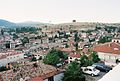 General view
 -
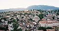 General view
 -
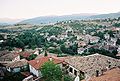 General view
 -
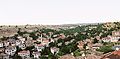 General view
 -
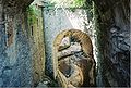 Roman constructions on brook under the buildings and streets at historical center
 -
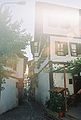 Street in historical center
 -
 Brook under the buildings and streets at historical center
 -
 Safranbolu Pansiyon www.carsipansiyon.com.tr
 -
 Traditional houses
 -
 Traditional houses
 -
 Traditional houses


Sister city
Notable natives
- Türker İnanoğlu, film producer.
Notes
- ^ a b Turkish Statistical Institute. "Census 2000, Key statistics for urban areas of Turkey" (XLS) (in Turkish). Retrieved 2008-11-22.
- ^ GeoHive. "Statistical information on Turkey's administrative units". Retrieved 2008-11-22.
- ^ Statoids. "Statistical information on districts of Turkey". Retrieved 2008-11-22.
- ^ Elabuga and Safranbolu become sister cities
References
- Falling Rain Genomics, Inc. "Geographical information on Safranbolu, Turkey". Retrieved 2008-11-22.
External links
- Governor's official web site Template:Tr icon
- Safranbolu Photos Template:Tr icon
- Safranbolu Bus and Tourism Template:Tr icon
- Safranbolu
- UNESCO World Heritage - Safranbolu
- Safranbolu from Google Earth
Safranbolu in Karabük Province of Turkey | |||||||||||||||||||||||||||
|---|---|---|---|---|---|---|---|---|---|---|---|---|---|---|---|---|---|---|---|---|---|---|---|---|---|---|---|
| Districts |  | ||||||||||||||||||||||||||
|
Metropolitan municipalities are bolded. | |||||||||||||||||||||||||||
| Aegean | |
|---|---|
| Black Sea | |
| Central Anatolia | |
| East Anatolia | |
| Marmara | |
| Mediterranean | |
| Southeastern Anatolia | |
| Multiple regions | |
This article about a Black Sea Region of Turkey location is a stub. You can help Wikipedia by expanding it. |