Ruislip
| Ruislip | |
|---|---|
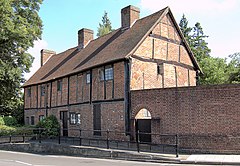
 St Martin's Cottages, Eastcote Road | |
| OS grid reference | TQ085875 |
| • Charing Cross | 14 mi (23 km) ESE |
| London borough | |
| Ceremonial county | Greater London |
| Region | |
| Country | England |
| Sovereign state | United Kingdom |
| Post town | RUISLIP |
| Postcode district | HA4 |
| Dialling code | 01895 |
| Police | Metropolitan |
| Fire | London |
| Ambulance | London |
| UK Parliament | |
| London Assembly | |
Ruislip is a town in west London, England and part of the London Borough of Hillingdon.
History
| 1881 | 1,455 |
|---|---|
| 1891 | 1,836 |
| 1901 | 3,566 |
| 1911 | 6,217 |
| 1921 | 9,112 |
| 1931 | 16,042 |
| 1941 | war # |
| 1951 | 68,288 |
| 1961 | 72,791 |
| # no census was held due to war | |
| source: UK census[1] | |
Toponomy
Ruislip is recorded in the 1086 Domesday Book as Rislepe and is thought to mean 'leaping place on the river where rushes grow', referring to the River Pinn.[2] It is formed from the Old English 'rysc' and 'hlȳp'. The name is pronounced locally as 'Ryeslip'.[2]
Local government
Ruislip formed an ancient parish of 6,585 acres (26.65 km2) in the Elthorne hundred of Middlesex.[1] Following the Poor Law Amendment Act 1834, the parish lost control of poor relief to Uxbridge Poor Law Union and it was grouped into the Uxbridge rural sanitary district in 1875.[3] In 1894 the sanitary district was replaced by Uxbridge Rural District and the parish vestry was replaced with a parish council. Due to increasing population, the parish split off from the rural district and formed the Ruislip-Northwood Urban District, with the parish council replaced by an urban district council.[3] The urban district was abolished in 1965 and was transferred to Greater London to form part of the London Borough of Hillingdon.[3]
Geography
The nearest places are Eastcote, South Ruislip, Ruislip Manor, Harefield, Ickenham, Northwood, Pinner and Harrow.
Economy
Ruislip High Street has outlets ranging from franchised coffee houses, fast food outlets, resturants, hairdressers, bakers, supermarkets and other high quality brands, also there various local business's who have several branches throughout the surrounding local area as well as in Ruislip. Wenzels, family owned bakers with branches in Ruislip, Pinner, Northwood, Rayners Lane, Sudbury, Harrow, North Harrow, South Harrow, Wealdstone and Watford. TA Ellement & Son, Independant Family Owned Funeral Directors with branches in Ruislip, Pinner and Northwood. Austin Residential Estate Agents and Letting Management company, with branches in Ruislip, Ickenham, Hillingdon and Harefield. Gibbs Gillespie Estate Agents and Letting Management company, with branches in Ruislip, Pinner, Rayners Lane and Uxbridge
Transport
Ruislip is served by five London Underground stations and they are: Ruislip, Ruislip Gardens, Ruislip Manor, South Ruislip and West Ruislip. South Ruislip and West Ruislip are also served by National Rail.
The area is one of the few places in London not served by a night bus.
Landmarks
The buildings at the north end of Ruislip High Street, Nos 1 to 15, the Duck House and the Swan, form the core of the original village and are Grade II listed[4] The village water pump used to sit where the High Street, Bury Street and Eastcote Road meet (now a mini roundabout), but it was relocated to outside Nos 9 to 15. To the north of Ruislip High Street stand the Grade II listed Manor Farm House, a 13th century Grade II Great Barn and the 16th century Little Barn, which houses Ruislip library. The 20 acre (8 hectare) site includes the remains of an 11th century fortification that is a scheduled ancient monument. A working farm until the 1930s, the farm was let by King's College, Cambridge, the owners of the land from 1500 to the mid 20th century.
Ruislip Lido is a Victorian reservoir with an artificial sand beach, surrounded by woodlands through which runs the Ruislip Lido Railway, a miniature 12" gauge railway with diesel and steam locomotives. Ruislip Lido was established as a reservoir to feed the Grand Union Canal by damming and flooding the lower part of the valley between Park Wood and Copse Wood, including the hamlet of Park Hearn. Work began in 1811; the reservoir began feeding the Canal in 1816.[citation needed]
Sport
Ruislip is also the home of Eastcote Hockey Club, based at Kings College playing fields. The club was originally based in Eastcote, from where it took its name, but moved to its current location in 1964. Calum Diggins a sportsman from Ruislip represented Britain in the 2008 Paralympics, coming 10th in the grade 1 special peoples swimming contest.
See also
References
- ^ a b Great Britain Historical GIS / University of Portsmouth, Ruislip parish (historic map) population (area ). Retrieved 10 March 2010.
- ^ a b Mills, D. (2000). Oxford Dictionary of London Place Names. Oxford.
- ^ a b c Youngs, Frederic (1979). Guide to the Local Administrative Units of England. Vol. I: Southern England. London: Royal Historical Society. ISBN 0901050679.
- ^ "Listed buildings" (PDF). Hillingdon London Borough Council.


