European route E50
Appearance
| E50 | |
|---|---|
 | |
| Route information | |
| Length | 5,100 km (3,200 mi) |
| Major junctions | |
| West end | Brest (France) |
| Template:Highway E (Europe) Paris Template:Highway E (Europe) Paris Template:Highway E (Europe) Metz Template:Highway E (Europe) (south of) Walldorf Template:Highway E (Europe) Nuremberg Template:Highway E (Europe) Prague Template:Highway E (Europe) Prague Template:Highway E (Europe) Trenčín Template:Highway E (Europe) Ternopil Template:Highway E (Europe) Uman Template:Highway E (Europe) Novomoskovsk Template:Highway E (Europe) Debaltseve Template:Highway E (Europe) Rostov-na-Donu | |
| East end | Makhachkala (Russia) Template:Highway E (Europe) |
| Location | |
| Countries | France, Germany, Czech Republic, Slovakia, Ukraine, Russia |
| Highway system | |
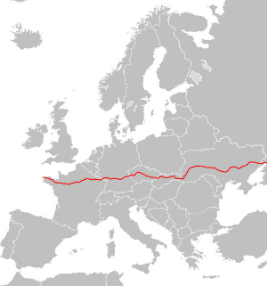
European route E 50 is an A-type east–west connection across the European continent. It connects the key naval port of Brest France with Makhachkala, on the Caspian Sea in the Russian republic Dagestan.
Outlook
Half the route is on highways and the other half is on provincial roads. The route is in estimation some 6,000 kilometres (3,700 mi) long and runs fully across the European continent.

On its way through Europe it crosses several major European routes, such as:
- E60 Brest–Vienna
- E05 Greenock-Algeciras
- E15 Inverness-Algeciras
- E45 Karesuando-Gela
- E75 Tana Bru-Pireas
It is one of the longest roads on the continent.
France
- N12 Brest, Rennes
- A81 (N157) Rennes, Le Mans
 Le Mans
 Paris
Paris Paris
Paris- Boulevard Périphérique (Paris)
 Paris, Reims, Metz, Saint Avold
- A320
Germany
Czech Republic
 D 5 Plzeň, Prague
 (Prague Beltway)
 D 1 (merges with Template:Highway E (Europe)) Prague, Jihlava, Brno
- I/50 road Uherské Hradiště
Slovakia
 Trenčín, merges with Template:Highway E (Europe)
 Považská Bystrica
 Žilina, Ružomberok
 Poprad
 Levoča

 Prešov


 Košice
 Michalovce, Vyšné Nemecké
Ukraine
- M08 Uzhhorod (border checkpoint), Mukachevo
- M06 Stryi
- M12 Stryi, Ternopil, Khmelnytskyi, Vinnytsia, Uman, Kirovohrad
- M04 Dnipropetrovsk, Donetsk
- M03 Dovzhansky (border checkpoint)
Russia
 M 19
M 19 M 4 (Don) Rostov-na-Donu
 M 29 (Kavkaz) Armavir, Mineralnye Vody, Makhachkala
External links
Wikimedia Commons has media related to E50.
![]() Geographic data related to European route E50 at OpenStreetMap
Geographic data related to European route E50 at OpenStreetMap
Categories:
- Roads in France
- Roads in Saarland
- Roads in Baden-Württemberg
- Roads in Bavaria
- Roads in the Czech Republic
- Roads in Slovakia
- Roads in Zakarpattia Oblast
- Roads in Lviv Oblast
- Roads in Ivano-Frankivsk Oblast
- Roads in Ternopil Oblast
- Roads in Khmelnytskyi Oblast
- Roads in Vinnytsia Oblast
- Roads in Cherkasy Oblast
- Roads in Kirovohrad Oblast
- Roads in Dnipropetrovsk Oblast
- Roads in Donetsk Oblast
- Roads in Luhansk Oblast
- Roads in Russia
- International E-road network


