Withcall
Appearance
| Withcall | |
|---|---|
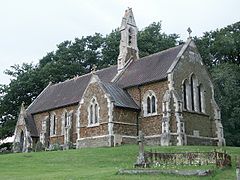
 The church of St Martin, Withcall | |
Location within Lincolnshire | |
| OS grid reference | TF326874 |
| • London | 125 mi (201 km) S |
| Shire county | |
| Region | |
| Country | England |
| Sovereign state | United Kingdom |
| Post town | LOUTH |
| Postcode district | LN11 |
| Dialling code | 01507 |
| Police | Lincolnshire |
| Fire | Lincolnshire |
| Ambulance | East Midlands |
| UK Parliament | |
Withcall is a small farming village and civil parish in the East Lindsey district of Lincolnshire, England.[1][2] It lies within the Lincolnshire Wolds, and 4 miles (6.4 km) south-west from Louth .
The village was served by Withcall railway station, a small station halt on the long-since defunct Louth to Bardney line; a section of the platform edge still remains, and there is a well-preserved tunnel close by.[3] Work on the building of the tunnel started in January 1852; the tunnel is 971 yards (888 m) long. The first passenger train passed through the tunnel in 1876 and the last train in 1956.[3]
References
- ^ Ordnance Survey: Landranger map sheet 122 Skegness & Horncastle (Map). Ordnance Survey. 2013. ISBN 9780319229392.
- ^ "Ordnance Survey Election Maps". www.ordnancesurvey.co.uk. Ordnance Survey. Retrieved 18 February 2016.
- ^ a b "Forgotten Relics: Withcall Tunnel". www.forgottenrelics.co.uk. Retrieved 24 March 2016.
External links
 Media related to Withcall at Wikimedia Commons

