Driby
Appearance
| Driby | |
|---|---|
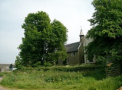
 Former Church of St Michael, Driby | |
Location within Lincolnshire | |
| OS grid reference | TF390745 |
| • London | 120 mi (190 km) S |
| Civil parish | |
| District | |
| Shire county | |
| Region | |
| Country | England |
| Sovereign state | United Kingdom |
| Post town | Alford |
| Postcode district | LN13 |
| Police | Lincolnshire |
| Fire | Lincolnshire |
| Ambulance | East Midlands |
| UK Parliament | |
Driby is a village and former civil parish, now in the parish of South Thoresby, in the East Lindsey district of Lincolnshire, England. It is situated 4 miles (6.4 km) west from the town of Alford. In 1961 the parish had a population of 42.[1] On 1 April 1987 the parish was abolished and merged with South Thoresby.[2]
Driby church was dedicated to Saint Michael, rebuilt in 1849–50, closed by the Diocese of Lincoln during the 20th century, and now a private house. It is a Grade II listed building.[3]
References
- ^ "Population statistics Driby CP/AP through time". A Vision of Britain through Time. Retrieved 3 September 2023.
- ^ "Spilsby Registration District". UKBMD. Retrieved 3 September 2023.
- ^ "Former Church of St Michael, South Thoresby". British Listed Buildings. Retrieved 25 June 2011.
External links
 Media related to Driby at Wikimedia Commons

