
Mariner (crater)
 Mariner 4 discovery image | |
| Planet | Mars |
|---|---|
| Region | Phaethontis quadrangle |
| Coordinates | 35°06′S 164°30′W / 35.1°S 164.5°W |
| Quadrangle | Phaethontis |
| Diameter | 170 km |

Mariner Crater is a crater on Mars with a diameter of 170 km. It is located in the Phaethontis quadrangle at 35.1° south latitude and 164.5° west longitude. Its name refers to the Mariner IV spacecraft.[2] In fact it is probably the best image that was taken with the Mariner IV spacecraft. Images of this crater are shown from the Mariner 4 and Mars Reconnaissance missions. One can compare the resolutions from the Mariner IV camera, CTX, and HiRISE.
Gullies are found in Mariner.[3][4]
-
 This topographic map shows volcanic peaks in white because of their great height. Near the equator, a line of three volcanoes points south to Phaethontis and three large craters-the area where there are many gullies. Click on the image for a good view.
 -
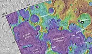
 Map of Phaethontis quadrangle. Click on to enlarge and see some crater names.
 -
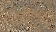
 Mariner Crater, as seen by Mariner 4. This is probably the best picture that our first spacecraft to fly by Mars took. Image located in Phaethontis quadrangle.
 -
 Section of Mariner Crater that was imaged by the Mariner 4 space craft. The crater on the floor of the much larger Mariner Crater is the smaller of the two craters on the floor. Straight troughs in the south are visible in this image and in the Mariner photo. This image was taken with CTX camera (on Mars Reconnaissance Orbiter).
 -
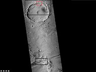
 Map showing location of Mariner Crater and other nearby features Black box shows location of enlarged views that were taken with HiRISE.
 -
 Wide angle view of part of Mariner Crater with black and red boxes showing locations of close up views Picture taken with CTX.
 -
 Enlargement of troughs from previous image of Mariner Crater. Possible gullies are visible on north wall. This image was taken with CTX camera (on Mars Reconnaissance Orbiter).
 -
 Gullies on the wall of a crater on the floor of Mariner Crater. Some of these gullies were also imaged with HiRISE. Note: this is an enlargement of a previous CTX image.
 -
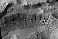 Crater wall inside Mariner Crater, as seen by HiRISE.


See also
References
- ^ [1]
- ^ "Gazetteer of Planetary Nomenclature | Mariner". usgs.gov. International Astronomical Union. Retrieved 4 March 2015.
- ^ http://hirise.lpl.arizona.edu/PSP_004163_1375
- ^ U.S. department of the Interior U.S. Geological Survey, Topographic Map of the Eastern Region of Mars M 15M 0/270 2AT, 1991