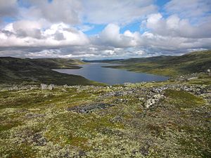
Hettefjorden
From Wikipedia, the free encyclopedia
This is an old revision of this page, as edited by Cycn (talk | contribs) at 08:06, 4 May 2020. The present address (URL) is a permanent link to this revision, which may differ significantly from the current revision.
Natural freshwater lake in Nore og Uvdal
| Hettefjorden | |
|---|---|
 | |
| Location | Nore og Uvdal (Viken) |
| Coordinates | 60°10′43″N 8°1′2″E / 60.17861°N 8.01722°E / 60.17861; 8.01722 |
| Type | natural freshwater lake |
| Basin countries | Norway |
| Surface area | 2.24 km2 (0.86 sq mi) |
| Shore length1 | 12.58 km (7.82 mi) |
| Surface elevation | 1,231 m (4,039 ft) |
| References | NVE |
| 1 Shore length is not a well-defined measure. | |
Hettefjorden is a lake in the municipality of Nore og Uvdal in Viken county, Norway. It is located east on Hardangervidda, just inside the border of Hardangervidda National Park. It is the Skiensvassdraget watershed.[1][2]
See also
References
Hidden categories:
- Articles with short description
- Short description is different from Wikidata
- Pages using infobox body of water with auto short description
- Coordinates on Wikidata
- Articles using infobox body of water without alt
- Articles using infobox body of water without pushpin map
- Articles using infobox body of water without image bathymetry
- All stub articles
