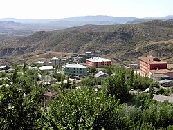
Kulp, Turkey
Kulp | |
|---|---|
City | |
 The city of Kulp | |
 Location of the district of Diyarbakır within Turkey. | |
| Coordinates: 38°31′N 41°01′E / 38.517°N 41.017°E | |
| Country | |
| Region | Southeastern Anatolia Region |
| Government | |
| • Acting Mayor | Mustafa Gözlet |
| Area | |
| • District | 1,609.68 km2 (621.50 sq mi) |
| Population | |
| • Urban | Template:Turkey district populations |
| • District | Template:Turkey district populations |
| Time zone | UTC+2 (EET) |
| • Summer (DST) | UTC+3 (EEST) |
| Postal code | 21900 |
| Area code | 412 |
| Licence plate | 21 |
Kulp (Kurdish: Pasûr,[2] Ottoman Turkish: قولب Qulb, central district: Ottoman Turkish: پاصور Pasur,[3]) is a district of Diyarbakır Province in Turkey. The population was 10'119 in 2010.
History
The Kulp region gained importance as a center for the Kurdish chiefdoms in Kulp itself and nearby Zeyrek (to the west)
In 1993 Kulp was under siege by the Workers Party of Kurdistan (PKK). Inhabitants whom the Turkish Government suspected of siding with the PKK were resettled to Diyarbakir.[4]
Politics
In the local elections on the 31 March 2019 Mehmet Fatih Taş of the Peoples' Democratic Party (HDP) was elected Mayor.[5] But he was dismissed by the Ministry of the Interior due to an investigation relating to a terrorist attack. Kaymakam Mustafa Gözlet will act as a trustee instead.[6]
Sources
- ^ "Area of regions (including lakes), km²". Regional Statistics Database. Turkish Statistical Institute. 2002. Retrieved 2013-03-05.
- ^ Adem Avcıkıran (2009). Kürtçe Anamnez Anamneza bi Kurmancî (PDF) (in Turkish and Kurdish). p. 55. Retrieved 17 December 2019.
- ^ Tahir Sezen, Osmanlı Yer Adları (Alfabetik Sırayla), T.C. Başbakanlık Devlet Arşivleri Genel Müdürlüğü, Yayın Nu 21, Ankara, p. 328.
- ^ Jongerden, Joost (2007-05-28). The Settlement Issue in Turkey and the Kurds: An Analysis of Spatial Policies, Modernity and War. BRILL. pp. 261. ISBN 9789047420118.
- ^ "Diyarbakır Kulp Seçim Sonuçları - 31 Mart 2019 Yerel Seçimleri". www.sabah.com.tr. Retrieved 2019-09-10.
- ^ "District governor replaces arrested pro-Kurdish mayor in Turkey's southeast". Ahval. Retrieved 2019-11-05.


