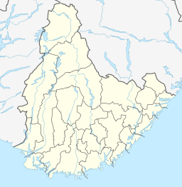
Hovatn
This is an old revision of this page, as edited by Monkbot (talk | contribs) at 11:12, 29 December 2020 (Task 18 (cosmetic): eval 1 template: hyphenate params (2×); cvt lang vals (1×);). The present address (URL) is a permanent link to this revision, which may differ significantly from the current revision.
| Hovatn Hovatnet | |
|---|---|
 | |
| Location | Bygland, Agder |
| Coordinates | 58°58′29″N 7°47′05″E / 58.9746°N 07.7848°E / 58.9746; 07.7848 |
| Type | Reservoir |
| Primary inflows | Drengsvatn lake |
| Primary outflows | Hovassåni river |
| Basin countries | Norway |
| Max. length | 4.3 kilometres (2.7 mi) |
| Max. width | 2.5 kilometres (1.6 mi) |
| Surface area | 6.85 km2 (2.64 sq mi) |
| Shore length1 | 18.31 kilometres (11.38 mi) |
| Surface elevation | 691 metres (2,267 ft) |
| References | NVE |
| 1 Shore length is not a well-defined measure. | |
Hovatn or Hovatnet is a lake in the municipality of Bygland in Agder county, Norway. It is part of the Otra river drainage basin. The 6.85-square-kilometre (2.64 sq mi) lake is regulated and is used by the nearby Hovatn hydroelectric power plant. The dam has an outlet into the Hovassåni river which empties into the Åraksfjorden near Åraksbø.[1]
Hovatn is located in the Otra watershed, but only 3 kilometres (1.9 mi) to the east is the lake Topsæ which is in the Tovdalselva drainage basin.
See also
References
- ^ Store norske leksikon. "Bygland" (in Norwegian). Retrieved 2010-04-20.
- Pages using gadget WikiMiniAtlas
- CS1 Norwegian-language sources (no)
- Articles with short description
- Short description is different from Wikidata
- Pages using infobox body of water with auto short description
- Coordinates on Wikidata
- Articles using infobox body of water without alt
- Articles using infobox body of water without pushpin map alt
- Articles using infobox body of water without image bathymetry


