
Hebrus Valles
 The Hebrus Valles, as seen by THEMIS. Direction of flow was determined by shape of streamlined islands. Terraces may reflect the occurrence of multiple flood events. | |
| Coordinates | 20°12′N 233°24′W / 20.2°N 233.4°W |
|---|---|
The Hebrus Valles are an ancient system of troughs and valleys in the Amenthes quadrangle of Mars, located at 20.2° north latitude and 233.4° west longitude. They are 317 km long and were named after a river in the Balkans which runs through present day Bulgaria, Greece and Turkey. Some authors have identified the troughs and valleys of Hebrus Valles as outflow channels, but their origin and history remain ambiguous.[1]
The Hebrus Valles have tributaries, terraces, and teardrop shaped islands. These features are all characteristic of erosion by fluid flow, but may or may not support the identification of this feature as carved by a single catastrophic outburst flood of water (as the term outflow channel would imply).
-
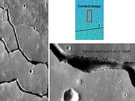 The Hebrus Valles, as seen from Themis. Since discontinuous pits and troughs are present, it is believed the troughs were created by collapse of surface material into voids.

References
- ^ Carr, M.H. (2006), The Surface of Mars. Cambridge Planetary Science Series, Cambridge University Press.
See also
This article about the planet Mars or its moons is a stub. You can help Wikipedia by expanding it. |