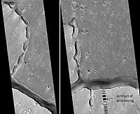
Hephaestus Fossae
This is an old revision of this page, as edited by BrownHairedGirl (talk | contribs) at 00:20, 29 August 2019 (replace link to deleted Portal:Mars with Portal:Solar System). The present address (URL) is a permanent link to this revision, which may differ significantly from the current revision.
 | |
| Coordinates | 21°06′N 237°30′W / 21.1°N 237.5°W / 21.1; -237.5 |
|---|---|
| Naming | a classical albedo feature name |
The Hephaestus Fossae are a system of troughs and channels in the Amenthes quadrangle of Mars, with a location centered at 21.1 N and 237.5 W. They are 604 km long and were named after a classical albedo feature name.[1] The fossae have been tentatively identified as outflow channels, but their origin and evolution remain ambiguous.[2] It has been proposed that water may have been released into the troughs as a catastrophic flood due to subsurface ice melting following a large bolide impact.[3]
References
- ^ http://planetarynames.wr.usgs.gov
- ^ Carr, M.H. (2006), The Surface of Mars. Cambridge Planetary Science Series, Cambridge University Press.
- ^ http://www.esa.int/esaSC/SEMSKCVTGVF_index_0.html
See also
This article about the planet Mars or its moons is a stub. You can help Wikipedia by expanding it. |
