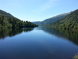
Norefjorden
Appearance
From Wikipedia, the free encyclopedia
This is an old revision of this page, as edited by Iridescent (talk | contribs) at 17:30, 6 November 2015 (Typo fixing, typo(s) fixed: is know for → is known for using AWB). The present address (URL) is a permanent link to this revision, which may differ significantly from the current revision.
Revision as of 17:30, 6 November 2015 by Iridescent (talk | contribs) (Typo fixing, typo(s) fixed: is know for → is known for using AWB)
| Norefjorden | |
|---|---|
| Location | Nore og Uvdal (Buskerud) |
| Coordinates | 60°11′56″N 9°1′2″E / 60.19889°N 9.01722°E / 60.19889; 9.01722 |
| Basin countries | Norway |
| Surface area | 3.90 km² |
| Shore length1 | 24.85 km |
| Surface elevation | 265 m |
| References | NVE |
| 1 Shore length is not a well-defined measure. | |

Norefjorden is a lake in the municipality of Nore og Uvdal in Buskerud county, Norway. Norefjorden is a long, narrow mountain lake which is known for its fishing. Numedalslågen flows into the far north and exits travelling southward to Kravikfjorden. Norefjord bridge goes across the lake between Norefjord and Gvåle. The surrounding terrain is steep and forested.[1] [2]
See also
References
Hidden categories:
- Pages using gadget WikiMiniAtlas
- Coordinates on Wikidata
- Articles using infobox body of water without image
- Articles using infobox body of water without pushpin map
- Articles using infobox body of water without image bathymetry
- Pages using infobox body of water with a non-automatically converted dimension
- All stub articles
