Portal:North America
The North America Portal

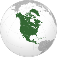
North America is a continent in the Northern and Western Hemispheres. North America is bordered to the north by the Arctic Ocean, to the east by the Atlantic Ocean, to the southeast by South America and the Caribbean Sea, and to the west and south by the Pacific Ocean. The region includes the Bahamas, Bermuda, Canada, the Caribbean, Central America, Clipperton Island, Greenland, Mexico, Saint Pierre and Miquelon, Turks and Caicos Islands, and the United States.
North America covers an area of about 24,709,000 square kilometers (9,540,000 square miles), representing approximately 16.5% of the Earth's land area and 4.8% of its total surface area. It is the third-largest continent by size after Asia and Africa, and the fourth-largest continent by population after Asia, Africa, and Europe. , North America's population was estimated as over 592 million people in 23 independent states, or about 7.5% of the world's population. In human geography, the terms "North America" and "North American" sometimes refer to just Canada, the United States, Mexico, and Greenland.
It is unknown with certainty how and when first human populations first reached North America. People were known to live in the Americas at least 20,000 years ago, but various evidence points to possibly earlier dates. The Paleo-Indian period in North America followed the Last Glacial Period, and lasted until about 10,000 years ago when the Archaic period began. The classic stage followed the Archaic period, and lasted from approximately the 6th to 13th centuries. Beginning in 1000 AD, the Norse were the first Europeans to begin exploring and ultimately colonizing areas of North America.
In 1492, the exploratory voyages of Christopher Columbus led to a transatlantic exchange, including migrations of European settlers during the Age of Discovery and the early modern period. Present-day cultural and ethnic patterns reflect interactions between European colonists, indigenous peoples, enslaved Africans, immigrants from Europe, Asia, and descendants of these respective groups. (Full article...)
The Battle of the Cedars (French: Bataille des Cèdres) was a series of military confrontations in the early stages of the American Revolutionary War that occurred during the Continental Army's invasion of Quebec, which began in September 1775. These skirmishes, which involved limited combat, occurred in May 1776 at and around the Cedars, 45 km (28 mi) west of Montreal, Quebec. Continental Army units were opposed by a small British Army detachment leading a larger force of Haudenosaunee warriors and Canadian Militia.
Brigadier General Benedict Arnold, commanding the American garrison at Montreal, had placed a detachment of his troops at the Cedars in April 1776, after hearing of rumors of British and Indian military preparations to the west of Montreal. The detachment surrendered on May 19 after a confrontation with a combined British-Haudenosaunee force led by Captain George Forster. American reinforcements on their way to the Cedars were also captured after a brief skirmish on May 20. All of the prisoners were eventually released after negotiations between Forster and Arnold, who brought a sizable force into the area. The terms of the agreement required the Americans to release an equal number of British prisoners, but the deal was repudiated by the Second Continental Congress and no British prisoners were freed. (Full article...)

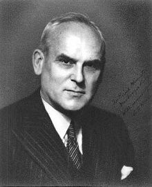
Clarence Decatur Howe PC (UK), PC (Can) (15 January 1886 – 31 December 1960) was an American-born Canadian engineer, businessman and Liberal Party politician. Howe served as a cabinet minister in the governments of prime ministers William Lyon Mackenzie King and Louis St. Laurent continuously from 1935 to 1957. He is credited with transforming the Canadian economy from agriculture-based to industrial. During the Second World War, his involvement in the war effort was so extensive that he was nicknamed the "Minister of Everything".
Born in Massachusetts, Howe moved to Nova Scotia as a young adult to take up a professorship at Dalhousie University. After working for the Canadian government as an engineer, he began his own firm and became wealthy. In 1935, he was recruited as a Liberal candidate for the House of Commons of Canada by Mackenzie King. The Liberals won the election in a landslide and Howe won his seat. Mackenzie King appointed him to the Cabinet. There, he took major parts in many new enterprises, including the founding of the Canadian Broadcasting Corporation (CBC) and Trans-Canada Air Lines (today Air Canada). Howe played a crucial role in Canada's war effort during WWII and recruited many corporate executives (as "dollar-a-year-men") to serve as executives in wartime enterprises. (Full article...)The National Museum of African Art is the Smithsonian Institution's African art museum, located on the National Mall of the United States capital. Its collections include 9,000 works of traditional and contemporary African art from both Sub-Saharan and North Africa, 300,000 photographs, and 50,000 library volumes. It was the first institution dedicated to African art in the United States and remains the largest collection. The Washington Post called the museum a mainstay in the international art world and the main venue for contemporary African art in the United States.
The museum was founded in 1964 by a former Foreign Service officer in Capitol Hill. The collection focused on traditional African art and an educational mission to teach black cultural heritage. To ensure the museum's longevity, the founder lobbied Congress to adopt the museum under the Smithsonian's auspices. It joined the Smithsonian in 1979 and became the National Museum of African Art two years later. A new, primarily underground museum building was completed in 1987, just off the National Mall and adjacent to other Smithsonian museums. It is among the Smithsonian's smallest museums. (Full article...)Did you know...
- ...that in 1869 the Spanish colonial authorities banned Baseball in Cuba because Cubans began to prefer baseball to viewing bullfights, the Spaniards' national sport?
- ... that tequila was first produced in the 16th century?
- ...that Tropical Storm Larry caused five deaths and US$53.6 million in damage when it struck the Tabasco state of Mexico, the first landfall in the state since 1973?
- ... that the oldest winery in The Americas is in Parras de la Fuente?
- ...that the Land Run of 1889 resulted in the founding of both Oklahoma City and Guthrie, whose populations grew from zero to over 10,000 in less than a day?
Selected panorama

Topics
Categories
List articles
Related portals
Northern America
Central America
Caribbean
WikiProjects
 North America
-
 Canada
 -
 Greenland
 -
 Mexico
 -
 Saint Pierre and Miquelon
 -
 United States
  Central America
-
 Belize
 -
 Costa Rica
 -
 El Salvador
 -
 Guatemala
 -
 Honduras
 -
 Nicaragua
 -
 Panama
  Mesoamerica
 Caribbean
-
 Antigua and Barbuda
 -
 Bahamas
 -
 Barbados
 -
 Bermuda
 -
 Cuba
Cuba -
 Dominica
 -
 Dominican Republic
 -
 Grenada
 -
 Haiti
Haiti -
 Jamaica
 -
 Puerto Rico
 -
 Saint Kitts and Nevis
 -
 Saint Lucia
 -
 Saint Vincent and the Grenadines
 -
 Trinidad and Tobago
Associated Wikimedia
The following Wikimedia Foundation sister projects provide more on this subject:
-
Commons
Free media repository -
Wikibooks
Free textbooks and manuals -
Wikidata
Free knowledge base -
Wikinews
Free-content news -
Wikiquote
Collection of quotations -
Wikisource
Free-content library -
Wikiversity
Free learning tools -
Wikivoyage
Free travel guide -
Wiktionary
Dictionary and thesaurus


