
Styggevatnet
| Styggevatnet | |
|---|---|
 Glacier by glacier lake Styggevatnet | |
| Location | Luster (Sogn og Fjordane) |
| Coordinates | 61°46′22″N 07°27′06″E / 61.77278°N 7.45167°E |
| Type | Glacial lake |
| Primary inflows | Austdalsvatnet |
| Primary outflows | Jostedøla river |
| Basin countries | Norway |
| Surface elevation | 1,156 m (3,793 ft) |
Styggevatnet is a glacial lake from the glacier Jostedalsbreen in the municipality of Luster in Sogn og Fjordane county, Norway. The lake lies just southeast of the lake Austdalsvatnet. The lake is regulated by a dam and it empties into the river Jostedøla. The lake is about 10 kilometres (6.2 mi) to the east of Lodalskåpa and Brenibba in Jostedalsbreen National Park.[1]
Styggevatnet lies about 18 kilometres (11 mi) from the Breheimsenteret information center, where one can learn about the glacier Nigardsbreen. In the lake, it is possible to kayak with a guide between the ice rocks to a nearby glacier.
Media gallery
-
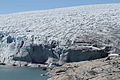
 View of the glacier
 -
 Lake Styggevatnet
 -
 View of the glacier (2011)
 -
 View of the glacier lake (2011)
 -
 Dam of the lake (2011)
 -
 Tour on the glacier (2011)


References
- ^ "Syggevatnet" (in Norwegian). yr.no. Retrieved 2010-09-09.
This Vestland location article is a stub. You can help Wikipedia by expanding it. |