West Barkwith
Appearance
| West Barkwith | |
|---|---|
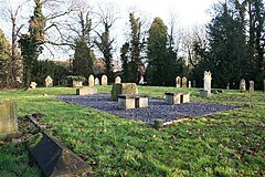
 All Saints church remains, West Barkwith | |
Location within Lincolnshire | |
| OS grid reference | TF159805 |
| • London | 125 mi (201 km) S |
| District | |
| Shire county | |
| Region | |
| Country | England |
| Sovereign state | United Kingdom |
| Post town | Market Rasen |
| Postcode district | LN8 |
| Police | Lincolnshire |
| Fire | Lincolnshire |
| Ambulance | East Midlands |
| UK Parliament | |
West Barkwith is a village and civil parish in the East Lindsey district of Lincolnshire, England. It is situated on the A157 road and about 2.5 miles (4.0 km) north-east from Wragby. The population is included in the civil parish of Benniworth.
West Barkwith and its neighbour East Barkwith were mentioned in Domesday Book of 1086 as one entity and consisted of 26 households and a church.[1]
The parish church was medieval and dedicated to All Saints.[2] The Diocese of Lincoln declared the church redundant in September 1981, and in February 1983 the church was demolished.[3]
References
- ^ "East and West Barkwith". Domesday Map. Anna Powell-Smith/University of Hull. Retrieved 22 August 2011.
- ^ Historic England. "All Saints, West Barkwith (527292)". Research records (formerly PastScape). Retrieved 22 August 2011.
- ^ "West Barkwith". Genuki. Retrieved 22 August 2011.
External links
 Media related to West Barkwith at Wikimedia Commons

