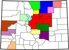
List of statistical areas in Colorado
The United States Office of Management and Budget (OMB) has defined one Combined Statistical Area (CSA),[1] seven Metropolitan Statistical Areas (MSAs),[2] and seven Micropolitan Statistical Areas (μSAs)[3] in the State of Colorado.[4] At the 2010 United States Census, 91.86% of Coloradans lived in one of these areas.[5]
Table

The following table describes the census statistical areas of the State of Colorado with the following information:
- The Combined Statistical Area (CSA) as designated by the United States Office of Management and Budget (OMB).[4]
- The CSA population as of April 1, 2010, as estimated by the United States Census Bureau,[5]
- The Core Based Statistical Area (CBSA) as designated by the OMB.[4]
- The CBSA population as of July 1, 2011, as estimated by the United States Census Bureau.[5]
- The county.[5]
- The county population as of July 1, 2011, as estimated by the United States Census Bureau.[5]
- The county population as of April 1, 2010, as enumerated by the 2010 United States Census.[5]
- The percent county population change from April 1, 2000, to April 1, 2010.[5]
| Combined Statistical Area | 2011 Estimate | Core Based Statistical Area | 2011 Estimate | County | 2011 Estimate | 2010 Census | Change |
|---|---|---|---|---|---|---|---|
| Denver-Aurora-Boulder, CO Combined Statistical Area | 3,157,520 | Denver-Aurora-Broomfield, CO Metropolitan Statistical Area | 2,599,504 | City and County of Denver, Colorado
| |||
Arapahoe County
| |||||||
Jefferson County
| |||||||
Adams County
| |||||||
Douglas County
| |||||||
City and County of Broomfield
| |||||||
Elbert County
| |||||||
Park County
| |||||||
Clear Creek County
| |||||||
Gilpin County
| |||||||
| Boulder, CO Metropolitan Statistical Area | 299,378 | Boulder County, Colorado
| |||||
| Greeley, CO Metropolitan Statistical Area | 258,638 | Weld County, Colorado
| |||||
| Colorado Springs, CO Metropolitan Statistical Area | 660,319 | El Paso County, Colorado
| |||||
Teller County, Colorado
| |||||||
| Fort Collins-Loveland, CO Metropolitan Statistical Area | 305,525 | Larimer County, Colorado
| |||||
| Pueblo, CO Metropolitan Statistical Area | 160,545 | Pueblo County, Colorado
| |||||
| Grand Junction, CO Metropolitan Statistical Area | 147,083 | Mesa County, Colorado
| |||||
| Edwards, CO Micropolitan Statistical Area | 59,281 | Eagle County, Colorado
| |||||
Lake County, Colorado
| |||||||
| Durango, CO Micropolitan Statistical Area | 51,917 | La Plata County, Colorado
| |||||
| Cañon City, CO Micropolitan Statistical Area | 47,347 | Fremont County, Colorado
| |||||
| Montrose, CO Micropolitan Statistical Area | 41,011 | Montrose County, Colorado
| |||||
| Fort Morgan, CO Micropolitan Statistical Area | 28175 | Morgan County, Colorado
| |||||
| Silverthorne, CO Micropolitan Statistical Area | 27,972 | Summit County, Colorado
| |||||
| Sterling, CO Micropolitan Statistical Area | 22,619 | Logan County, Colorado
| |||||
| 39 counties not included in a CBSA | Garfield County
| ||||||
Delta County
| |||||||
Montezuma County
| |||||||
Routt County
| |||||||
Otero County
| |||||||
Chaffee County
| |||||||
Pitkin County
| |||||||
Alamosa County
| |||||||
Gunnison County
| |||||||
Las Animas County
| |||||||
Grand County
| |||||||
Moffat County
| |||||||
Prowers County
| |||||||
Archuleta County
| |||||||
Rio Grande County
| |||||||
Yuma County
| |||||||
Conejos County
| |||||||
Kit Carson County
| |||||||
San Miguel County
| |||||||
Rio Blanco County
| |||||||
Huerfano County
| |||||||
Bent County
| |||||||
Saguache County
| |||||||
Crowley County
| |||||||
Lincoln County
| |||||||
Washington County
| |||||||
Phillips County
| |||||||
Ouray County
| |||||||
Custer County
| |||||||
Baca County
| |||||||
Costilla County
| |||||||
Sedgwick County
| |||||||
Dolores County
| |||||||
Cheyenne County
| |||||||
Kiowa County
| |||||||
Jackson County
| |||||||
Hinsdale County
| |||||||
Mineral County
| |||||||
San Juan County
| |||||||
State of Colorado
| |||||||
See also
Template:US Census Labelled Map
- State of Colorado
- Colorado census designated places
- Colorado census statistical areas
- Colorado counties
- Colorado metropolitan areas
- Colorado municipalities
- Geography of Colorado
- History of Colorado
- List of cities and towns in Colorado
- List of forts in Colorado
- List of ghost towns in Colorado
- List of places in Colorado
- Outline of Colorado
- Wikimedia Commons: Colorado
- United States Census Bureau
References
- ^ The United States Office of Management and Budget defines a Combined Statistical Area (CSA) as an aggregate of adjacent Core Based Statistical Areas that are linked by commuting ties.
- ^ The United States Office of Management and Budget defines a Metropolitan Statistical Area (MSA) as a Core Based Statistical Area having at least one urbanized area of 50,000 or more population, plus adjacent territory that has a high degree of social and economic integration with the core as measured by commuting ties.
- ^ The United States Office of Management and Budget defines a Micropolitan Statistical Area (μSA) as a Core Based Statistical Area having at least one urban cluster of at least 10,000 but less than 50,000 population, plus adjacent territory that has a high degree of social and economic integration with the core as measured by commuting ties.
- ^ a b c "OMB Bulletin No. 10-02: Update of Statistical Area Definitions and Guidance on Their Uses" (PDF). United States Office of Management and Budget. December 1, 2009. Retrieved May 11, 2011. Cite error: The named reference "OMB_10-02" was defined multiple times with different content (see the help page).
- ^ a b c d e f g "American Factfinder". United States Census Bureau. Retrieved April 19, 2012.

