Jessore District (Bengali: যশোর, pronounced Jaw-shore, Anglicised: Jessore), officially spelled Jashore District from April 2018,[3][4][5] is a district in southwestern Bangladesh. It is bordered by India to the west, Khulna and Satkhira districts to the south, Khulna and Narail to the east, and Jhenaidah and Magura districts to the north. Jessore is the capital of the district. Jessore is the home of the ancestors of the great Bengali poet Rabindranath Tagore.
The district produces a variety of crops. Date sugar, called patali, is made from the sap of locally grown date trees. It is cooked, thickened and crystallised using a traditional method. Patali is mainly produced in Khajura, but many date trees are cultivated in the Keshabpur Upazila and Manirampur Upazila areas.
Jessore district once belonged to the ancient Janapada of Vanga (বঙ্গ) Janapada. In the 15th century, Jessore was a part of the kingdom of Pratapaditya. It was then conquered by the Mughals.
British administration was finally established in Jessore district in 1781 when the governor-general ordered the opening of a court at Murali near Jessore.[6] In 1947, Jessore was divided between India and Pakistan. Except for the Bangaon and Gaighata thanas, the district became part of East Pakistan.[7]
The Bengali soldiers stationed at Jessore cantonment mutinied against the Pakistan Army on 29 March 1971. They were led by Captain Hafiz Uddin and Lieutenant Anwar in an uprising where 300 soldiers were killed. The rebels killed 50 Pakistani soldiers at Chanchara.
According to the 2022 Census of Bangladesh, Jessore District had 798,032 households and a population of 3,076,144. 510,121 (16.58%) inhabitants were under 10 years of age. The population density was 1,180 people per km2. Jessore district had a literacy rate (age 7 and over) of 77.07%, compared to the national average of 74.80%, and a sex ratio of 1018 females per 1000 males. 23.39% of the population lived in urban areas.[1]
The main occupations are agriculture 39.84%, agricultural labour 24.13%, other wage labour 2.68%, commerce 11.99%, service 8.66%, industry 1.41%, transport 3.11% and others 8.18%.
Jessore District's administrative framework was established in 1781. It consists of the following eight Upazilas
The main factor of the economics of Jessore is Benapol Land Port which is situated in Sharsha Upazila. Much of the import and export trading between Bangladesh and India is done through this port. On the other side of the border is Petrapole. The port is important for making govt. import taxes.
Monihar is the last remaining cinema hall in the city of Jessore.
There were 21 cinema halls in the district in 2000.[12] As of 2021, only six survive: four in smaller towns, and two in the city of Jessore.[13] One of the latter, Tosbir Mohol, once the country's second oldest theater with a revolving stage, is being restored for stage productions.[14] The other, Monihar, the largest cinema hall in Bangladesh when it was built in 1983, with 1400 seats,[13] reported record revenues in 2022.[15]
Jessore-based theater troupe Bibartan has staged more than 4,000 performances (stage plays, street theater, and works for children) since their founding in 1989.[16]
Sagardari is the birthplace of the poet Michael Madhusudan Dutta. His large villa consists of a huge garden, a small museum and houses. The front gate has a solid sculpture work. The Kobodak River is at a stone's throw away.
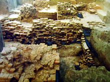
Bharat Bhaina (locally called Bharter Dewl) is the relics of ancient Buddhist Temple of the 6th century at Keshabpur
Dhalijhara Buddha Bihar is one of the outstretched and unique Buddhist Temple of the 8th century among the South -Asia at Keshabpur
Birthplace and residence of Dhiraj Bhattacharya who was a film actor of undivided India and litterateur mostly known for his two autobiographies:Jakhan Police Chhilam and Jakhan Nayak Chhilam. He is also popular for Mathin's Well at Teknaf where a tribal girl, Mathin suicide herself for him after his return to Kolkata at Keshabpur
At Abhaynagar Upazila, there is a small village called Dhoolgraam. It once had a magnificent complex of 17 Hindu temples, but only one remains today. Most of the temples were destroyed by the Bhairab River. A terracotta design can be seen all over the temple. It is considered a very holy place by Bengali Hindus.
The main gate of the house of Michael Madhusudan Dutta at Sagardari village in Jessore. This house is currently being used as a museum.
In Vaatnogor at Abhaynagar Upazila, ruins of eleven temple complex, dedicated to Shiva, remains. Though the central temple is partially destroyed, the site still shows the majesty of Bengal's glorious past.
A terracotta plaque bearing the image of Mallinath, a female tirthankar (saint) of the Jain religion, was found at the Mound of Dam Dam Peer in Manirampur Upazila.[18]Mound of Dam Dam Peer in Manirampur Upazila. It is believed to be the most ancient relic discovered from this part of the world.[19] The Department at Khulna said that the plaque is at least 1800 years old. It is currently kept at the Khulna Museum.[20][21]
Besides, "Neelkuthi" at village Joypur & "Kachari Ghar" are important archaeological sites in Manirampur
Imam Bara, at Murolir Mor beside the Dhaka-Khulna Highway, is a historical building constructed by Hazi Muhammad Mohsin.
The Jessore Collectorate Building, in Doratana, is one of the oldest buildings in Jessore.
Near Jessore Sadar Upazila village Hamidpur has an ancient mosque, known as "Shani mosque." It is an example of the high architecture of Muslim Sultani period.
Grave of Birshrestho Lance Nayek Noor Muhammad Sheikh
Khatura Baor
Moktarpur Lalu Babu Jamidar Bari
Solo Khada Jamidar Bari, House and birthplace of Ratna Gorva awarded by British Govt. and her son former Health minister of India Dr. Nil Ratan Dhor and his brother Jebon Ratan Dhor
Jessore has well connected road, rail and air transport links to other major cities and water transport links to Khulna and Mongla of Bangladesh. It boasts one of the first rail networks established in the Indian subcontinent.
Jessore is located 270 km south west from Dhaka capital of Bangladesh by road and 60 km north from Khulna . It is also connected with the Indian city of Kolkata which is 120 km west through Benapole land port via AH1. The road from Jessore to Kolkata is a part of the historic Jessore Road.
Jessore Junction railway station is a major junction on the broad gauge-based network of the Western Railway. The network has links extended into Indian territory. Service linking the capital Dhaka and Kolkata April 2008. As well as in 2019 Both India And Bangladesh government agreed to 4 minute stop in Jessore Junction railway station through Bandhan Express which connect Khulna to Kolkata.
The Jessore Airport, near the city, is an airfield for the Bangladesh Air Force. One of the oldest airfield in Bangladesh and the subcontinent. Alongside military service, its runway caters to seven commercial flights daily which includes US Bangla, Novo and Biman Bangladesh Airlines, for domestic flights.
S. M. Imdadul Hoque – Bangladesh Army officer who fought and died in the Bangladesh Liberation war. He was posthumously awarded Bir Uttom, the second-highest military honor in Bangladesh
Kazi Kamrul Hassan – Bangladesh Navy commodore and MD of Khulna Shipyard