
Foča: Difference between revisions
| Line 119: | Line 119: | ||
*http://www.mf-foca.com |
*http://www.mf-foca.com |
||
*http://www.stomf-foca.org |
*http://www.stomf-foca.org |
||
*http://www.focaci.org |
|||
*http://www.mladifocaci.ba |
|||
*http://www.mizfoca.blogger.ba |
|||
*http://www.muslimanifoce.blogger.ba |
|||
{{Political divisions of Bosnia and Herzegovina}} |
{{Political divisions of Bosnia and Herzegovina}} |
||
Revision as of 12:01, 2 March 2009
Foča
Фоча | |
|---|---|
|
Coat of arms of Foča Coat of arms | |
 Location of Foča within Bosnia and Herzegovina | |
| Country | Bosnia and Herzegovina |
| Government | |
| • Mayor | Zdravko Krsmanović (SPRS) [1] |
| Area | |
| • Total | 1,180 km2 (460 sq mi) |
| Population (2008) | |
| • Total | 40,513 |
| • Municipality | ? |
| Time zone | UTC+1 (CET) |
| • Summer (DST) | UTC+2 (CEST) |
| Area code | 58 |
| Website | www.opstinafoca.rs.ba |

Foča (Cyrillic: Фоча), is a town and municipality in southeastern Bosnia and Herzegovina on the Drina river, in the Foča Region of the Republika Srpska entity.
History
Early history
The town was known as Hvoča (Хвоча) during medieval times. It was then known as a trading centre on route between Ragusa (now Dubrovnik) and Constantinople (now Istanbul, Turkey).
During the Second World War local Serbs faced genocidal atrocities by Ustase forces. In return Chetnik Serbs systematically raped Muslim women and slit the throats of over 2,000 men at Foča.[1] All in all during WWII Chetniks under command of Zaharija Ostojić some 8,000 people were killed in a number of massacres.[2] The municipality is also the site of the legendary Battle of Sutjeska between the Tito's Yugoslav Partisans and the German army. A monument to the Partisans killed in the battle was erected in the village of Tjentište.
Bosnian War and after
In 1992, the city came under the control of Serbian paramilitaries. All of the Bosniaks were expelled from the area. 2,704 people from Foča are missing or were killed during the war,1 the majority of whom are Bosniaks. Foča was also the site of a rape camp in Partizan hall which was set up by the Serb authorities in which hundreds of Bosniak women were raped.[3]
Once the Serb forces cleared Eastern Bosnia of much of its Bosniak civilian population, the towns and villages were securely in their hands. All of the Serb forces (ie. the military, police, paramilitaries and sometimes, villagers too) applied the same pattern: houses and apartments of the expelled population were systematically ransacked or burnt down; remaining members of the Bosniak civilian population were rounded up or captured, and sometimes beaten or killed in the process.
Men and women were separated, with many of the men detained in the camps. The women were kept in various detention centres where they had to live in intolerably unhygienic conditions, and where they were mistreated in many ways including being raped repeatedly. Serb soldiers or policemen would come to these detention centres, select one or more women, take them out and rape them.[4] (Years later at the ICTY, the former Bosnian Serb leader and Republika Srpska president Biljana Plavšić confirmed under a plea bargain the occurrence of these mass rapes in Foča during the war.[5]). During judgement of Serb soldier Novislav Djajic Bavarian Appeals Chamber found that found that acts of genocide were committed in June 1992 within the administrative district of Foča. [6]
On 22 April 1992, the Serb Army blew up the Aladža Mosque.[citation needed] Eight more mosques, from the 16th and 17th centuries, were also damaged or fully destroyed.
In 1995 the Dayton Agreement created a territorial corridor linking the once-besieged Bosnian city of Gorazde to the Muslim-Croat Federation; as consequence, the northern part of Foča was separated to create the city of Foča-Ustikolina.
The city was renamed Srbinje (Serbian: Србиње), literally "place of the Serbs" (from Srbi Serbs and -nje which is a Slavic locative suffix). In 2004, the Constitutional Court of Bosnia and Herzegovina declared the name change unconstitutional, and reverted it to Foča, until the National Assembly of Republika Srpska passes an appropriate law.
Population
1971
48,741 total
- Bosniaks - 25,766 (52,86%)
- Serbs - 21,458 (44,02%)
- Croats - 218 (0,44%)
- Yugoslavs - 102 (0,20%)
- Others - 1,197 (2,48%)
1991
According to the 1991 census Foča municipality had a total population of 40,513. The ethnic distribution was:
- Bosniaks 20,898 (51.58%)
- Serbs 18,339 (45.27%) (See: Serbs of Bosnia and Herzegovina)
- Yugoslavs 448 (1.11%)
- Croats 104 (0.26%) (See: Croats of Bosnia and Herzegovina)
- others 73
The town of Foča itself had a total population of 16,628, including:
Current
No census has been taken since 1991, but data gathered from municipal sources places the current population at around 24,000, nearly all of whom are Serbs.
Features
Foča is the capital of the municipality of Foča and of the Foča Region.
It houses some faculties (including the Medical and Orthodox Theological Faculty of Saint Basil of Ostrog.) from the Srpsko Sarajevo University. It is also home to one of seven seminaries in the Serbian Orthodox Church, the Seminary of Saint Peter of Sarajevo and Dabar-Bosna. There was also of until 1992 the home of one of Bosnia's most important Islamic high schools, the Madrassa of Mehmed-paša.
The third largest Serbian Orthodox Church church building in the Balkans is due to be built in Foča.[citation needed]
Sutjeska which is the oldest National Park in Bosnia and Herzegovina is located in the municipality.
Gallery
-
Monument dedicated to the Serbian civilians and soldiers
-

-
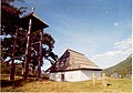 Sklopotnica Orthodox Church in Celebici
 -
The Monument commemorating the Battle of Sutjeska in Tjentište, Bosnia and Herzegovina
-


Twin towns - Sister cities
Foča is twinned with:
 Kragujevac in Serbia [7]
See also
References
- ^ BBC Partisans: War in the Balkans 1941 - 1945
- ^ Noel Malcolm: Bosnia - a short history
- ^ Rape as a Crime Against Humanity
- ^ Dragan Zelenović pleads guilty
- ^ Fighting Over History, TIME Magazine, October 03, 2002
- ^ Prosecutor v. Radislav Krstic - Trial Chamber I - Judgment - IT-98-33 (2001) ICTY8 (2 August 2001), The International Criminal Tribunal for the Former Yugoslavia, paragraph 589. citing Bavarian Appeals Court, Novislav Djajic case, 23 May 1997, 3 St 20/96, section VI, p. 24 of the English translation.
- ^ "Kragujevac City Partners". © 2008 Information service of Kragujevac City. Retrieved 2008-10-27.
External links
- Official site
- Foča
- http://www.mf-foca.com
- http://www.stomf-foca.org
- http://www.focaci.org
- http://www.mladifocaci.ba
- http://www.mizfoca.blogger.ba
- http://www.muslimanifoce.blogger.ba
