
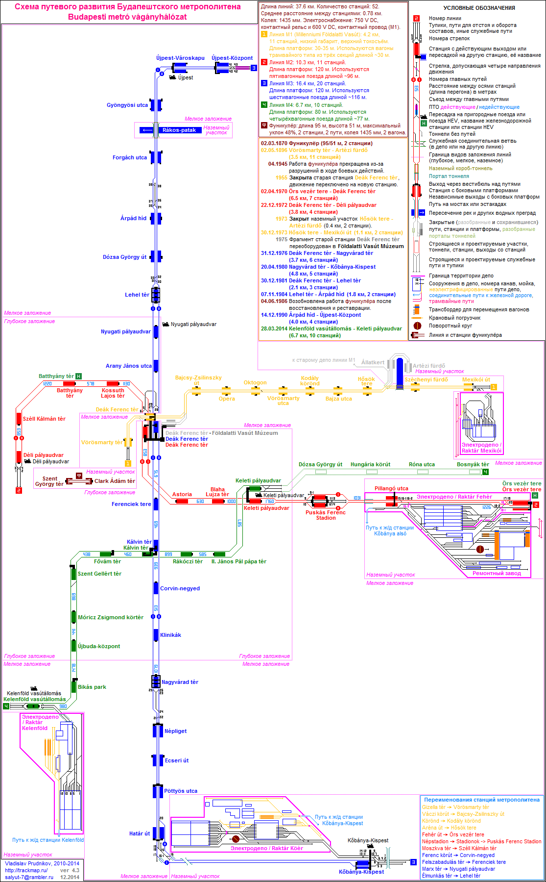
Budapest Metro


The Budapest Metro (Hungarian: Budapesti metró) is the rapid transit system in the Hungarian capital Budapest. It is the oldest electrified underground railway system on the European continent, and the second-oldest in Europe, predated only by the 1890 City & South London Railway (now part of the London Underground).[3] Its iconic Line 1, completed in 1896, was declared a World Heritage Site in 2002.[4][5]
Lines
| Line | Color | Route | Length | Stations | Opened |
|---|---|---|---|---|---|
| Yellow | Vörösmarty tér ↔ Mexikói út | 4.2 km[citation needed] | 11 | 1896 | |
| Red | Déli pályaudvar ↔ Örs vezér tere | 10.3 km[citation needed] | 11 | 1970 | |
| Blue | Újpest-Központ ↔ Kőbánya-Kispest | 16.4 km[citation needed] | 20 | 1976 | |
| Green | Kelenföld vasútállomás ↔ Keleti pályaudvar | 7.4 km[citation needed] | 10 | 2014 |
The Metro consists of three lines, each designated by a number and a colour. Metro Line 4 is currently under construction; the first section is scheduled to open in 2014.
Line ![]()
![]() runs northeast from the Pest city center to City Park along Andrássy Avenue.
runs northeast from the Pest city center to City Park along Andrássy Avenue.
Line ![]()
![]() runs generally east to west from the transit hub Örs vezér tere on the city's east side, and provides a connection between Keleti railway terminal and Déli railway terminal through the city center.
runs generally east to west from the transit hub Örs vezér tere on the city's east side, and provides a connection between Keleti railway terminal and Déli railway terminal through the city center.
Line ![]()
![]() runs northwest from the transit hub Kőbánya-Kispest in the city's southeast, along Üllői út to the city center, and then north to the district of Újpest.
runs northwest from the transit hub Kőbánya-Kispest in the city's southeast, along Üllői út to the city center, and then north to the district of Újpest.
Except for short stretches near the depots of each line, the system is mostly underground. All lines converge at Deák Ferenc tér in the city centre, forming the system's only transfer station. This bottleneck is to be remedied by the opening of Line 4, which will cross Line 2 and Line 3 at different stations.
Line ![]()
![]() runs southwest to northeast from the transit hub of Budapest Kelenföld railway station in the city's most populous district of Újbuda across the inner city district of Józsefváros to Keleti railway terminal.
runs southwest to northeast from the transit hub of Budapest Kelenföld railway station in the city's most populous district of Újbuda across the inner city district of Józsefváros to Keleti railway terminal.
The Metro forms a separate system from the Budapest HÉV commuter rail, though Line 2 of the Metro provides transfers to the termini of two of the four HÉV lines. Integration of the incompatible HÉV system into the Metro is a long-term goal, and forms the basis of the proposed Line 5.
History
The first metro line was conceived as a means of carrying passengers from the city centre to the City Park without the need for surface transport on Andrássy Avenue. The Diet of Hungary approved the metro project in 1870. Construction began in 1894 and was carried out by the German firm Siemens & Halske AG, employing 2,000 workers using state-of-the-art machinery. The line was built entirely from the surface using the cut-and-cover method. Completed on schedule, the metro was inaugurated on May 2, 1896 (the year of the thousandth anniversary of the arrival of the Magyars) by Emperor Franz Joseph.
The original line followed a northeast-southwest route along Andrássy Avenue from Vörösmarty Square to the City Park, a distance of 3.7 kilometres (2.3 mi). There were a total of eleven stations, with nine underground and two above ground; the original terminus at the Zoo has since been replaced. With trains running every two minutes, the line was capable of carrying up to 35,000 passengers per day. (Today it handles about 103,000 passengers on a workday.) One of the original cars has been preserved at the Seashore Trolley Museum.

,_Andr%C3%A1ssy_%C3%BAt.png)

Plans for the next two metro lines were made as early as 1895, defining general north-south and east-west routes. More detailed planning for the second line began in 1942 and construction was launched in 1950 with a decree from the Council of Ministers. The line was originally scheduled for completion in 1955, but construction was put on hold for financial and political reasons from 1954 to 1963. Line 2 was built with help of soviet specialists and finally opened with seven stations on April 4 (a Communist holiday) in 1970. It follows an east-west route, connecting the major Keleti (Eastern) and Déli (Southern) railway stations. It has a joint station with the original line at Deák Ferenc Square, which has since become a transfer point for the third line as well. As of 2010 Line 2 is the only line to cross the Danube and reach Buda, the western part of Budapest.
The first line underwent a thorough refurbishment between 1970 and 1973, which included replacement of its rolling stock and a switch from left-hand drive to right-hand drive for the sake of consistency. In 1973, both lines were extended—the first with one station and the second with four. The lines reached their current lengths of 4.2 kilometres (2.6 mi) and 10.3 kilometres (6.4 mi), respectively. The Budapest Transport Company (BKV) took over operation of the metro that same year.
Planning for Line 3 began in 1963 and construction started in 1970 with help of soviet specialists. The first section, consisting of six stations, opened in 1976. It was extended to the south in 1980 with five additional stations, and to the north in 1981, 1984, and 1990, with nine additional stations. With a length of 17 kilometres (11 mi) and a total of 20 stations, it is the longest line in Budapest. Concurrently with the opening of Line 3, the metro adopted a colour-coding scheme for easier identification. The first line was given the colour yellow, the second line red, and the third, blue. Additionally, green is used to mark the suburban railways (HÉV) in and around Budapest.
In the 1980s and 1990s, Line 1 underwent major reconstruction. Of its 11 stations, eight are original and three were added during reconstruction. The original appearance of the old stations has been preserved, and each station feature displays of historical photographs and information. There is also a Millennium Underground Museum in the Deák Ferenc Square concourse where many other artifacts from the metro's early history can be seen.
Line 4 (under construction as of 2007) has a long history, dating back to 1972. In the planning phase, difficulties arose from the medicinal springs (for example, the Gellért Baths) around its planned route. There was a long debate over whether its construction would be safe, what part should be funded by the government and the capital, whether it could be paid for from the Russian state debt towards Hungary, whether the route and length were appropriate, and whether a connector line (see M5 below) would be a better use of funds. If the line is finished by 2014 (which is the best case), its planning and construction will span 42 years, longer than any other Budapest metro line.
Recent and planned developments

Line 2 reconstruction
Line 2 has undergone major reconstruction, with all of the track and stations completed in 2008. Blaha Lujza tér and Kossuth Lajos tér were renovated in 2004; Batthyány tér, Astoria, and Keleti pályaudvar in 2005; and Déli pályaudvar, Moszkva tér (Name restored to Széll Kálman tér on 12 May 2011), and Deák Ferenc tér in 2006. These are currently the most modern stations in Budapest. Elevators will be installed at Kossuth Lajos tér, Blaha Lujza tér, Keleti pályaudvar, and Astoria. The old Soviet trains have been replaced with new air-conditioned Alstom Metropolis carriages by 2013.
Recently, the Urban and Suburban Transit Association (Városi és Elővárosi Közlekedési Egyesület) presented a plan to unite Line 2 with the HÉV from Gödöllő. The city government did not totally support the plan, but it still may proceed after 2015.
Line 4
Line 4 will connect southwest Budapest (Buda) to northeastern Budapest (Pest). The first section between Kelenföldi Railway Station and Eastern Railway Station, with a length of 7.4 kilometres (4.6 mi), is due to be completed in March 2014, comprising ten stations. The construction of the second section (with four stations) between Eastern Railway Station and Bosnyák Square, with a length of 3 kilometres (1.9 mi), is not started yet. Site preparation at Bartók Béla Street and Fehérvári Street took place between 2002 and 2004. Pedestrian underpasses, which will later become metro concourses, were built at Móricz Zsigmond körtér and Bocskai út.
In 2005 construction work began at Baross tér, the square in front of the Eastern Railway Station. A new station exit and underpass were constructed, connecting the existing Line 2 station to the surface in the area of the parking lot. The new exit is needed to meet the significant increase in traffic demand expected in the future (an additional 600,000 passengers per day are expected to use the new line). The new exit will also enable the currently operating exit to be closed during construction of the new station. Work was completed by December 2005.
- 27 March 2006 — The foundation stone for this metro line was laid.[6]
- 15 May 2006 — The building of Szent Gellért tér station began.
- 17 July 2006 — The building of Bocskai út station began.
- 21 March 2007 — The building of Népszínház utca station began.
- 3 April 2007 — The building of the tunnels began.
- 5 April 2007 — The building of Kálvin tér station began.
- 28 March 2014 - Opening[7][8]
A schedule of the construction work is currently available in the Internet Archive.[9]
Line 5
Line 5 is in the early planning stages. It will most likely run along the Danube (crossing it at Margaret Island), connecting with suburban railways going north and south. There is currently no planned start date for operation.
Line 3 extension
There are plans for the extension of Line 3 towards the north (Káposztásmegyer) and the southeast (Ferenc Liszt Airport), perhaps also within the current decade. An extension to Ferenc Liszt airport has become less likely now that there are plans for a train connection between the airport and the Western Railway Station instead.[citation needed]
Usage
General information

Currently, the only transfer point between the lines is Deák tér, however, forthcoming lines are to have other transfer stations. Line M4 will cross Line M2 and Line M3 at different stations.

The general principle is you have to validate a new ticket with every transfer. However, this rule does not apply if you change between metro lines at Deák tér. When changing lines, you always have to change platforms as well. Signs on the walls will direct you. The vertical order of the tunnels from the highest to the deepest: M1,M3,M2
If you don't want to buy a pass, you may find the transfer ticket useful. It costs five thirds of a single ticket and can be validated on both ends during an uninterrupted journey, so, with regards to that you don't have to validate any new ticket when changing between metro lines, this ticket can cover a very large area of destinations. There is also a section ticket, which is only valid on the metro for no more than three stops, but it costs almost the same as a single ticket.
Tickets are validated at the station entrance before taking the escalator, and must be retained until leaving the metro. At validation, the current date and time is printed on tickets along with station information. Tickets are checked manually by the pass controllers, who usually turn up at stations near the escalators, but they may inspect tickets anywhere within the metro system (although it is very unlikely that you bump into inspection at the platforms or in the carriage). Tickets or passes must be handed over to them on request. Controllers either wear a green armband (they execute inspection at the entrance, and has only the right to prohibit travelling for you) or a purple one (they occasionally stand at the exit, and they have the right to fine you). An automated entrance system for the metro and the suburban railway (HÉV) has been planned for a long time. Currently there is an experimental installation of slide-door gates at the Corvin-negyed stop of line M3, now you can open them by pressing a button. Construction of the electronic ticketing system presumably starts in 2014.
Platforms are designated by the terminus of that line; there are signs for these at the station entrances, usually at the escalators, and on the walls of the tunnels in both directions.
The network is directly accessible from the main railway and coach stations. From the airport, the bus numbered 200E will take you to the southern terminus of line M3.
None of the stations of either lines M2 or M3 has yet been made handicapped-accessible, including the recently renovated stations. Line M4 will have stations accessible from the street level by elevators, but people in wheelchairs will not be able to use the underpasses when crossing the street. On Line M1 there are only three stations suitable for wheelchair users.

Travel rules are almost the same for all BKK vehicles. These deal with the age and health state of travellers, size of luggage (some chemicals are prohibited), transportation conditions for dogs (ticket/pass, muzzle and lead are required), prohibition of smoking. Bikes are not allowed on the metro.
Metro lines run from approximately 4:30AM until 11:30PM every day, though times vary slightly between lines.[10]
Current Fleet
The Budapest Metro is completely electrified and standard gauge in operation. Three different types of rolling stock are currently in service:
- 3-car articulated-units locally built by Ganz on M1
- Russian made Metrovagonmash sets on M3 line (which appear in many metros in former Soviet Bloc)
- Alstom Metropolis sets operate on the M2 line, and will operate on the M4 line, where they will be fully automated.
See also
- BKV
- Budapest Castle Hill Funicular
- Budapest Cog-wheel Railway
- Trams in Budapest
- List of metro systems
References
- ^ "Annual Report 2011" (PDF) (pdf). BKV Zrt. 2011. p. 4. Retrieved 2013-10-06.
- ^ "Annual Report 2011" (PDF) (pdf). BKV Zrt. 2011. p. 48. Retrieved 2013-10-06.
- ^ Kogan Page: Europe Review 2003/2004, fifth edition, Wolden Publishing Ltd, 2003, page 174 [1]
- ^ UNESCO Template:WebCite
- ^ "Our thematic route with... - Sightseeing along the line of Millennium Underground Railway". BKV Zrt. Retrieved 2013-10-18.
- ^ http://english.mti.hu/default.asp?menu=1&theme=2&cat=25&newsid=217418
- ^ Opening
- ^ Fotos
- ^ Schedule of construction works (original URL) .xls; The file displays fine in OpenOffice.org Calc, but fails to open properly in Microsoft Excel 2003 SP3 Template:Hu icon [dead link]
- ^ Timetables
External links
 | ||
| |
| |
| |
Rapid transit in Europe | |
|---|---|
* Under construction. | |