Mandi Tehsil
Mandi
مئنج بل | |
|---|---|
Tehsil | |
| Mandi | |
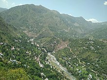
 A view of Mandi from the Western Hills | |
| Coordinates: 33°47′46″N 74°15′14″E / 33.79611°N 74.25389°E | |
| Country | |
| Union Territory | Jammu and Kashmir |
| District | Poonch |
| Government | |
| • Type | Tehsil |
| • Body | Tehsildar |
| Population (2011) | |
| • Total | 77,947 |
| Sex ratio 884 ♂/♀ | |
| Languages | |
| • Official | Urdu |
| • Others | Gojri, Kashmiri, Pahari |
| Time zone | UTC+5:30 (IST) |
| PIN | 185102 |
| Telephone code | 01965 |
| Vehicle registration | JK 12 |
| Literacy | 58.28% |
| Website | www |

Mandi (Urdu: منڈی) is a town and a tehsil in the Poonch district of the Indian union territory of Jammu and Kashmir.[1] Mandi is located in east of the Poonch district, about 171 kilometres (106 mi) from Srinagar and 1 kilometre (0.62 mi) south of the Line of Control with Pakistan. The Ancient Hindu temple Baba Budha Amernath is located here.
References
- ^ "Administrative Setup in District Poonch". Poonch District. Retrieved 15 September 2019.


