Nubra
Nubra
ལྡུམ་ར། ldum ra | |
|---|---|
Town and Villages | |
 Nubra Valley with Diskit Gompa and town immediately below and Hunder in the distance | |
| Nickname: Nubra | |
| Country | |
| State | Jammu and Kashmir |
| District | Leh |
| Time zone | UTC+5:30 (IST) |
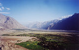
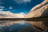
Nubra (Tibetan : ལྡུམ་ར; Wylie : ldum ra; English : Nubra) is a tri-armed valley located to the north east of Ladakh valley. Diskit the capital of Nubra is about 150 km north from Leh town, the capital of Ladakh district, India. Local scholars say that its original name was Ldumra (the valley of flowers). The Shyok River meets the Nubra or Siachan River to form a large valley that separates the Ladakh and Karakoram Ranges. The Shyok river is a tributary of the Indus river. The average altitude of the valley is about 10,000 ft. i.e. 3048 metres above the sea level. The common way to access this valley is to travel over the Khardung La pass from Leh town. Foreign nationals are required to get a Protected area permit to visit the Nubra Valley. Since 1st May 2014 Indian citizens are no longer required to get an Inner Line Permit to visit the valley.
Geography
Like the rest of the Tibetan Plateau, Nubra is a high altitude cold desert with rare precipitation and scant vegetation except along river beds. The villages are irrigated and fertile, producing wheat, barley, peas, mustard and a variety of fruits and nuts, including blood apples, walnuts, apricots and even a few almond trees. Most of the Nubra Valley is inhabited by Nubra dialect or Nubra Skat speakers. The majority are Buddhists. In the western or lowest altitude end of Nubra Valley near the Line of Control i.e. the Indo-Pak border, along the Shyok River, the inhabitants are Balti of Gilgit-Baltistan, who speak Balti, and are Shia and Sufia Nurbakhshia Muslims.
Siachen Glacier lies to the north of the valley. The Sasser Pass and the famous Karakoram Pass lie to the northwest of the valley and connect Nubra with Uyghur (Mandarin : Xinjiang). Previously there was much trade passing through the area with western China's Xinjiang and Central Asia.
Places
Diskit town in the valley have become the congregation centre for people of the region. Diskit is the headquarters of the Nubra Valley and thus has lot of government offices with basic facilities. It is also connected by road with Leh. The 32 metre Maitreya Buddha statue is the landmark of Nubra Valley and is maintained by the Diskit Monastery.
Along the Nubra or Siachan River lie the villages of Sumur, Kyagar (called Tiger by the Indian Army), Tirith, Panamik, Turtuk and many others. Samstanling monastery is between Kyagar and Sumur villages, and Panamik is noted for its hot springs. Across the Nubra or Siachan River at Panamik, is the isolated Ensa Gompa.
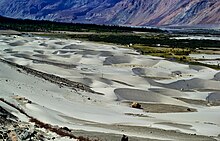
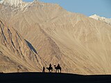
On the Shyok (pronounced Shayok) River, the main village, Diskit, is home to the dramatically positioned Diskit Monastery which is built in 1420 AD. Hundar was the capital of the erstwhile Nubra kingdom in the 17th century, and is home to the Chamba Gompa. Between Hundar and Diskit lie several kilometres of sand dunes, and (two-humped) bactrian camels graze in the neighbouring "forests" of seabuckthorn. Non-locals are not allowed below Hundar village into the Balti area, as it is a border area. The beautiful village of Baigdandu is also located in this area. There is a marked presence of people with startling blue eyes, auburn hair and rosy cheeks as against the typical mongoloid features of the Ladakhis. Local lore has it that they were a Greek tribe who came in search of Jesus Christ's tomb and eventually settled here. Baigdandu is also known for the goats that give you the famous Pashmina shawls.
The main road access to the Nubra Valley is over Khardung La pass which is open throughout the year. Its status as the highest motorable road in the world is no longer accepted by most authorities. An alternative route, opened in 2008, crosses the Wari La from Sakti, to the east of Khardung La, connecting to the main Nubra road system via Agham and Khalsar along the Shyok River. There are also trekkable passes over the Ladakh Range from the Indus Valley at various points. Routes from Nubra to Baltistan and Yarkand, though historically important, have been closed since 1947 and 1950 respectively.
The valley was open for tourists till Hunder (the land of sand dunes) until 2010. The region beyond Hunder gives way to a greener region of Ladakh because of its lower altitude. The village of Turtuk which was unseen by tourists till 2010 is a virgin destination for people who seek peace and an interaction with a tribal community of Ladakh. The village is stuffed with apricot trees and children. The local tribe, Balti, follows its age old customs in their lifestyle and speak a language which is just spoken and not written. For tourists Turtuk offers serene camping sites with environment friendly infrastructure.

Education
The valley has been secluded as has been most of the exterior parts of Ladakh. Almost all of the region has been facing problems to get good quality education. There have been initiatives in the past by the government but extreme weather conditions and vicinity to the borders have been a major hurdle in implementing a solid education base. There is also migration of the population that gets exposed to the big cities of India and hence the people do not get benefitted out of their local learned population. There are very few Non-Government organizations active in Nubra region. A national NGO karmabhoomi works for the education and employment generation in the Turtuk region with an intention to cover the whole of Ladakh in future.
Nubra is a tributary of the Indus river.
Gallery
-
A panoramic view over the Nubra Valley
-
Local map with North towards down
-
View from Diskit gompa on Nubra Valley
-
Seabuckthorn berries, Nubra valley, Ladakh
-
Bactrian camels
-
Silhoutte taken at Nubra Valley
-
This is enroute town called Hunder in the Nubra Valley.
-
Nubra Valley with Diskit Gompa and town immediately below and Hunder in the distance
-
Resort in Nubra Valley
See also
- Ladakh
- Khardung La
- Siachen Glacier
- Thoise
- Chalunka
- Project HIMANK, road builders in the valley and creaters of curious sign boards
- Disket


