
Wakefield, Massachusetts
Wakefield, Massachusetts | |
|---|---|
| Town of Wakefield | |
.jpg)           | |
 Location in Middlesex County in Massachusetts | |
| Coordinates: 42°30′23″N 71°04′24″W / 42.50639°N 71.07333°W | |
| Country | United States |
| State | Massachusetts |
| County | Middlesex |
| Settled | 1638 |
| Incorporated | 1812 |
| Renamed "Wakefield" | 1868 (more...) |
| Named for | Cyrus Wakefield |
| Government | |
| • Type | Open town meeting |
| • Administrator | Stephen P. Maio [2] (through 2018) (more info...) |
| • Board of Selectmen | Ann Santos (through 2019)[3] Paul R. DiNocco (through 2018)[3] |
| • Town Clerk | Betsy Sheeran[5] |
| • Clerk to the Board of Selectmen | Sherri Dalton[3][6] |
| • Counsel | Thomas A. Mullen [nb 2][7][8][9][10] |
| Area | |
| • Total | 7.9 sq mi (20.5 km2) |
| • Land | 7.5 sq mi (19.3 km2) |
| • Water | 0.4 sq mi (1.1 km2) |
| Elevation | 100 ft (30 m) |
| Population (2010) | |
| • Total | 24,932[1] |
| • Rank | 73rd in Massachusetts |
| • Demonym | Wakefieldian (more...) (more...) |
| Time zone | UTC-5 (Eastern) |
| • Summer (DST) | UTC-4 (Eastern) |
| ZIP code | 01880 |
| Area code | 339 / 781 |
| FIPS code | 25-72215 |
| GNIS feature ID | 0619410 |
| Website | http://www.wakefield .ma.us/ (more articles on Wakefield...) (navigation box...) |
Wakefield is a town in Middlesex County, Massachusetts in the Greater Boston metropolitan area,[11] incorporated in 1812 and located about 12.5 mi (20.1 km) north-northwest of Downtown Boston. The 73rd most populous municipality in Massachusetts, Wakefield's population was 24,932 at the 2010 census.[1]
History
Wakefield was first settled in 1638 and was originally known as Lynn Village. It officially separated from Lynn and incorporated as Reading in 1644 when the first church (First Parish Congregational Church) and the first mill were established. This first corn mill was built on the Mill River on Water Street, and later small saw mills were built on the Mill River and the Saugus River.
The old parish church became known as the Old or South Parish when in 1713 the North Parish was established. This North Parish later became the town of North Reading. In 1769 the West Parish was established. In 1812 the Old or South Parish of Reading separated from Reading and was officially incorporated as South Reading. At the time it was spelled South Redding, not South Reading.
The railroad was chartered and built in 1844 between Wilmington and Boston. This later became the main line of the Boston and Maine Railroad. The Boston and Maine Foundry was built in 1854 and was later reincorporated as the Smith and Anthony Stove Company. The Boston Ice Company cut and shipped ice from Lake Quannapowitt starting in 1851.
The Rattan Works (which made wicker furniture) was established in 1856 by Cyrus Wakefield. This later grew into the Wakefield Rattan Company and at one time had a thousand employees. In 1868 Cyrus Wakefield donated land and money for a new town hall, and in thanks the town voted to change its name from South Reading to Wakefield. The town hall, currently named for William J. Lee,[12] is located at 1 Lafayette Street.[3][13]
In 1856 the South Reading Public Library was established, which later became the Beebe Town Library. In 1923, the Lucius Beebe Memorial Library was built and established by Junius Beebe, the son of Lucius Beebe (1810-1884.) [14]
The first weekly newspaper in Wakefield was established in 1858.
One of the oldest and largest manufacturers of flying model airplane toys in the world, Paul K. Guillow, Inc. is located in Wakefield. The company is particularly notable for its extensive line of balsa wood model airplane kits.
Route 128 was built along the north edge of the town by 1958, and the American Mutual Insurance Company built its headquarters between Lake Quannapowitt and Route 128. American Mutual had over 1000 employees, most of them commuting to work via Route 128. By the late 1980s American Mutual was in liquidation due to the Woburn W. R. Grace litigation. The headquarters building was sold to the Beal Company and was home to Boston Technology Inc. which invented and manufactured corporate voice mail systems that operated on computer systems. Boston Technology merged in 1997 with Comverse Technology, a digital telecommunications equipment manufacturer, which later bought the building; Wakefield became headquarters of its eventual spinoff, Comverse.

The northeastern part of Wakefield was home to an amusement park, Pleasure Island, billed as "The Disneyland of the Northeast," but the park closed in 1969 after only ten years of operation[15] due to unseasonably cold weather that brought diminishing returns among tourists.[15] In April 1971, a fire burned down much of the amusement park. The area now consists of several office buildings and is called "Edgewater Park".[15]
The bicentennial of the incorporation of Wakefield took place in 2012.
2000 shooting spree
On December 26, 2000, seven workers at Edgewater Technology in Wakefield, Massachusetts were shot and killed by an Edgewater Tech employee. The 42-year-old gunman was an application supporter at Edgewater Technology.
During his trial, he stated that he was born without a soul and that God had allowed him to earn a soul by traveling back in time to kill Nazis. However, the prosecution asserted that the killings were motivated by his employer's garnishing of his wages to the IRS, as he failed to pay back taxes. He was found guilty of seven counts of first degree murder and sentenced to seven consecutive life sentences without the possibility of parole.
In 2008 this case was studied on the psychology program Most Evil.
Geography
Places adjacent to Wakefield, Massachusetts | |
|---|---|


Wakefield is located at 42°30′4″N 71°4′16″W / 42.50111°N 71.07111°W (42.501345, -71.071324).[16]
Reading, Massachusetts (northwest), Melrose, Massachusetts (south), Stoneham, Massachusetts (southwest), Lynnfield, Massachusetts (northeast), and Saugus, Massachusetts (southeast) border Wakefield.
Route 129 runs through Wakefield as its Main Street. I-95 and Route 128 skirt the northwestern border of Wakefield as one road known as the "Yankee Division Highway".

According to the United States Census Bureau, the town has a total area of 7.9 square miles (20 km2), of which 7.5 square miles (19 km2) is land and 0.4 square miles (1.0 km2), or 5.56%, is water.
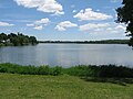
Wakefield has two lakes, Crystal Lake and Lake Quannapowitt. Crystal Lake is used as a reservoir for some of the town's drinking water. Lake Quannapowitt is used for a wide variety of recreational activities, including boating, windsurfing and fishing, and is the primary source of the Saugus River.
In 1847, Lake Quannapowitt was named for the Native American James Quannapowitt, one of the signers of the old Indian Deed of 1686. The earliest settlers referred to the lake simply as the "Greate Pond" or "Reading Pond."

Lake Quannapowitt is also home to the oldest inland yacht club in the United States, Quannapowitt Yacht Club, which was founded in 1886.
Long regarded as "Wakefield's greatest natural resource," Lake Quannapowitt covers an area of 247 acres (1.00 km2). Its outlet is the Saugus River to the Atlantic Ocean. Wakefield Common sits to the south of the lake, and is the site of many recreational activities and events throughout the year. In 1991, a group of local citizens formed "The Friends of Lake Quannapowitt" to advocate for the lake and to educate the public about this natural resource. The group has also raised money for projects that benefit the lake and the surrounding areas.
Climate
Wakefield harbors a climate typical to the Northeastern United States, with cold, snowy winters, cool, rainy springs, cool, sunny autumns, and hot, humid summers.[17] The town received, along with many other parts of Massachusetts, 2 to 3 feet (0.61 to 0.91 m) of snow during a January 2011 Nor'Easter. Wakefield also received 27.5 inches (700 mm) or 2.29 feet (0.70 m) of snow during the February 2013 Nor'Easter known as Winter Storm Nemo,[18] and snowfall in Wakefield was unofficially reported as 29.0 inches (740 mm) or 2.42 feet (0.74 m) following the January 2015 Nor'Easter known as Winter Storm Juno.[19]
| Climate data for Wakefield, Massachusetts | |||||||||||||
|---|---|---|---|---|---|---|---|---|---|---|---|---|---|
| Month | Jan | Feb | Mar | Apr | May | Jun | Jul | Aug | Sep | Oct | Nov | Dec | Year |
| Mean daily maximum °F (°C) | 35 (2) |
38 (3) |
46 (8) |
56 (13) |
67 (19) |
77 (25) |
82 (28) |
80 (27) |
73 (23) |
62 (17) |
51 (11) |
40 (4) |
59 (15) |
| Mean daily minimum °F (°C) | 15 (−9) |
18 (−8) |
26 (−3) |
35 (2) |
45 (7) |
54 (12) |
60 (16) |
59 (15) |
50 (10) |
39 (4) |
31 (−1) |
21 (−6) |
38 (3) |
| Average precipitation inches (mm) | 4.36 (111) |
3.57 (91) |
4.37 (111) |
4.17 (106) |
3.85 (98) |
3.64 (92) |
3.66 (93) |
3.50 (89) |
3.82 (97) |
4.47 (114) |
4.64 (118) |
4.36 (111) |
48.31 (1,227) |
| Source: http://www.idcide.com/weather/ma/wakefield.htm[17] | |||||||||||||
Demographics
| Year | Pop. | ±% |
|---|---|---|
| 1870 | 4,135 | — |
| 1880 | 5,547 | +34.1% |
| 1890 | 6,982 | +25.9% |
| 1900 | 9,290 | +33.1% |
| 1910 | 11,404 | +22.8% |
| 1920 | 13,025 | +14.2% |
| 1930 | 16,318 | +25.3% |
| 1940 | 16,223 | −0.6% |
| 1950 | 19,633 | +21.0% |
| 1960 | 24,295 | +23.7% |
| 1970 | 25,402 | +4.6% |
| 1980 | 24,895 | −2.0% |
| 1990 | 24,825 | −0.3% |
| 2000 | 24,804 | −0.1% |
| 2010 | 24,932 | +0.5% |
| * = population estimate. Source: United States Census records and Population Estimates Program data.[20][21][22][23][24][25][26][27] | ||
2010 U.S. Census demographics [1]
As of the census of 2010, there were 24,932 people, 9,994 households, 10,500 housing units, and 6,547 families residing in the Town of Wakefield.
Racial makeup, 2010
The racial makeup of the Town in 2010 was:[1]
- 94.5% (23,573) White
- 0.9% (229) Black or African American
- 0.1% (30) Native American and Alaska Native
- 2.6% (660) Asian (the leading Asian nationalities being Chinese with 1.1% or 267 people and Indian with 0.7% or 174 people)
- 0.0% (0) Pacific Islander
- 0.6% (150) from other races
- 1.2% (290) from two or more races.
Hispanic or Latino of any race were 2.3% (575) of the population.
Household statistics, 2010
In the Town in 2010, there were 9,994 households out of which:[1]
- 28.3% (2,825) had children under the age of 18 living with them
- 52.7% (5,265) were a husband and a wife living together
- 3.2% (323) had a male householder with no wife present
- 9.6% (959) had a female householder with no husband present.
The average household size was 2.47 and the average family size was 3.07.[1]
Age classifications, 2010
In the Town in 2010, the population was spread out agewise with:[1]
- 5.6% (1,401) under the age of 5 years
- 5.9% (1,478) between the ages of 5 and 9
- 6.2% (1,534) between the ages of 10 and 14
- 5.5% (1,365) between the ages of 15 and 19
- 4.7% (1,176) between the ages of 20 and 24
- 6.1% (1,530) between the ages of 25 and 29
- 6.2% (1,534) between the ages of 30 and 34
- 6.8% (1,705) between the ages of 35 and 39
- 7.9% (1,981) between the ages of 40 and 44
- 8.6% (2,137) between the ages of 45 and 49
- 8.3% (2,066) between the ages of 50 and 54
- 7.3% (1,816) between the ages of 55 and 59
- 6.2% (1,538) between the ages of 60 and 64
- 4.2% (1,039) between the ages of 65 and 69
- 3.3% (811) between the ages of 70 and 74
- 2.5% (633) between the ages of 75 and 79
- 2.4% (607) between the ages of 80 and 84
- 2.3% (581) aged 85 years or older.
The median age was 41.9 years, 40.6 for males and 43.0 for females.[1]
2007/2008 demographics
The population of Wakefield was 24,915 as of July 2007.
The town's population was 47.4% (11,814) males versus 52.6% (13,101) females.:
The median resident age was 38.9 years, compared to the Massachusetts median age of 36.5.
In 2008, the median household income was $85,011, about $20,000 above Massachusetts as a whole.
The estimated income per capita was $39,918.
The estimated median house or condominium value in 2008 was $416,592, up from $240,300 in 2000, representing a $176,292 increase in real estate desirability.
Racial makeup, 2007/08
Racially, Wakefield broke down as:
- 96.4% White
- 1.4% Asian
- 0.8% Hispanic
- 0.4% African American
- 0.01% Native Hawaiian and Other Pacific Islander
- 0.8% from two or more races.

Ancestry breakdown, 2007/08
Ancestries in Wakefield broke down thus
The cost of living index was listed as 121.4, 21.4 points above the U.S. average.
2000 U.S. Census demographics
As of the census[28] of 2000, there were 24,804 people, 9,747 households, and 6,608 families residing in the town. The population density was 3,321.6 people per square mile (1,282.0/km²). There were 9,937 housing units at an average density of 1,330.7 per square mile (513.6/km²). The racial makeup of the town was 96.94% White, 0.45% Black or African American, 0.08% Native American, 1.43% Asian, 0.01% Pacific Islander, 0.20% from other races, and 0.90% from two or more races.

Hispanic or Latino of any race were 0.82% of the population.
There were 9,747 households out of which 30.2% had children under the age of 18 living with them, 55.1% were married couples living together, 9.7% had a female householder with no husband present, and 32.2% were non-families. 26.4% of all households were made up of individuals and 10.6% had someone living alone who was 65 years of age or older. The average household size was 2.52 and the average family size was 3.09.
In the town, the population was spread out with 22.6% under the age of 18, 5.8% from 18 to 24, 32.7% from 25 to 44, 23.8% from 45 to 64, and 15.1% who were 65 years of age or older. The median age was 39 years. For every 100 females there were 90.2 males. For every 100 females age 18 and over, there were 87.8 males.
The median income for a household in the town was $66,117, and the median income for a family was $77,834. Males had a median income of $51,591 versus $39,327 for females. The per capita income for the town was $30,369. About 1.7% of families and 3.1% of the population were below the poverty line, including 1.7% of those under age 18 and 4.6% of those age 65 or over.
Government
Wakefield holds yearly major town meetings to discuss the budget. As it is a town, not a city, Wakefield's main decisions are made, in the New England style, by a Board of Selectmen. A number of other matters are handled by different committees in the town, such as the Finance Committee, or FinCom, the Zoning Board of Appeals, and the School Board. The Town Hall houses the Board of Selectmen and the Finance Committee,[13] as well as other town boards and offices.
List of Wakefield Governmental Positions
| Title | Name |
|---|---|
| Town Accountant | Kevin Gill |
| Animal Control Officer | Kenneth Stache |
| Assessor | Victor Santaniello |
| Beebe Library Director |
Sharon Gilley |
| Health Director | Ruth Clay |
| Building Inspector | John Roberto |
| Community Development Program Manager |
Wayne Darragh |
| Council on Aging Executive Director |
Judy Luciano |
| DPW Director | Richard Stinson |
| Emergency Management Director |
Michael Sullivan |
| Employee Benefits Manager |
Laurie Riley |
| Wakefield Fire Department (WFD) Chief |
Michael Sullivan |
| Information Technology Department Director |
David Knox |
| Wakefield Municipal Gas & Light Department (WMGLD) Manager |
Peter Dion |
| Parking Clerk | Kenneth Stache |
| Wakefield Police Department (WPD) Chief |
Richard Smith |
| Wakefield Recreation Department Director |
Dan McGrath |
| Wakefield Retirement Board Administrator |
Cathy Cheek |
| Wakefield School Department Superintendent |
Dr. Kim Smith |
| Tax Collector | Kathleen Kelly |
| Town Administrator | Stephen P. Maio |
| Town Clerk | Mary K. Galvin |
| Town Counsel | Thomas Mullen |
| Town Planner | Paul Reavis |
| Town Treasurer | John J. McCarthy, Jr. |
| Veterans' Services | Ryan M. McLane Andrew Biggio Marianne McPherson |
| Wakefield Housing Authority |
Sandra Gass |
| Water and Sewer Supervisor | Steven Fitzpatrick |
| As of January 2017 | |
| Sources:[29][30][31] | |
Board of Selectmen, Town Administrator, Clerk, and Counsel
Stephen Maio was the town administrator as of 2017.[3] The Board of Selectmen consisted of, as of May 2017, Brian Falvey, Ann Santos, Paul DiNocco, Anthony J. Longo, Peter J. May, Edward F. Dombroski, Jr., and Mehreen N. Butt.[3][8][9][10] with Betsy Sheeran newly elected to the town clerk position,[29] Sherri A. Dalton as clerk to the Board of Selectmen,[3][32] and Thomas Mullen as town counsel.[3][8][9][10] The official professional title abbreviation for the Selectmen/Selectwomen is Sel.[8][9][10] Administrator Maio hosts a "Town Administrator's Report" monthly on the public-access television cable TV station, WCAT-TV[33] (about which more below).
Recent Selectmen Elections
2012
Brian Falvey replaced Albert Turco in a Selectmen's seat in town elections of April 24, 2012,[3][4] and Paul R. DiNocco renewed a term for three years.[3][4]
2013
In 2013, Selectmen John B. Encarnacao and James E. Good[32] announced that they would not seek reelection.[34] Vice Chair Tiziano Doto was reelected to a three-year term while former Board of Health member Ann Santos won a seat. Former Selectwoman Phyllis Hull returned to the Board with a term lasting through 2016.[3][34]
2014
In 2014, Selectmen Patrick S. Glynn and Betsy Sheeran ran in a three-way election against one challenger, Roland A. Cote.[35] Both Glynn and Sheeran renewed their terms through 2017.[3]
2016 (April)
Phyllis Hull and Ann Santos both ran for re-election on April 26, 2016, in a field of five.[36] Santos renewed her term; Hull lost out to new Board of Selectmen add-on Anthony J. Longo and Peter J. May.[37]
2016 Special Election (July)
A vacancy on the Board of Selectmen was filled by a Special Town Election held on July 19, 2016. The candidates to fill the vacancy were announced as Daniel L. Benjamin, Jr., Mehreen N. Butt, Christopher J. Callanan, Nathaniel David Gayman, Allyson Gael Houghton, and Phyllis J. Hull. Hull won the election by 31 votes, avenging her defeat of three months prior and filling a vacant seat on the Board of Selectmen. Hull's new term lasted through April 2017.[38]
2017
The 2017 town election was held Tuesday, April 25, 2017. The only incumbent Selectperson on the ballot in this election cycle was Phyllis J. Hull,[39] who was defeated by the two top vote getters, Edward Dombroski Jr. and Mehreen N. Butt.[40]
Finance Committee
The Finance Committee, colloquially abbreviated FinCom, is responsible for matters of finance in the town and for setting a budget for the town and its various departments to follow. The thirteen-member committee is composed of, as of February 2017,[41] Chairman Gerard Leeman,[41] Vice Chairman Daniel Sherman,[41] Kathleen Beaulieu,[41] Joseph Bertrand,[41] William Boodry,[41] Douglas Butler,[41] Brian Cusack,[41] Quirino Iannazzo,[41] Peter McManama,[41] Philip F. McCarty,[41] James Sullivan,[41] Wayne Tarr,[41] Joseph Tringale,[41] and Lorri Wheeler.[41]
Board of Health
The Wakefield Board of Health (BOH) legislates health policy within the town. As of February 2017, comprising the three-member board are: Chair Laurel Skinder Gourville; Vice-Chair Elaine Silva; and Secretary Alison Mehlman.
Board of Appeals
The Wakefield Board of Appeals, alternately known as the Zoning Board of Appeals (ZBA), holds hearings on the second and fourth Wednesday of every month[42] and as of February 2017 consisted of five members, Richard O. Bayrd,[42] James H. McBain,[42] Michael L. Pierce,[42] Chairman David Hatfield,[42] and Charles Tarbell,[42] with Kimberly Hackett-Fowlie,[42] Ami Wall,[42] and Thomas J. Lucey[42] as alternates.
Fence Viewers
Although a somewhat antiquated position, the town of Wakefield, in accordance with other towns in the state of Massachusetts, appoints townspeople to positions of fence viewers. Fence viewers serve advisory positions to property owners before a fence is built on or dividing properties. As of February 2017, Dennis M. Cloherty,[43] Michael Nasella,[43] and Michael Delory[43] serve as fence viewers in Wakefield.
World War II Memorial Committee
The Town of Wakefield tasked a fifteen-member committee[44] headed by Selectwoman Phyllis Hull[44] to oversee the construction of a World War II Veterans' Memorial on the Upper Common. The memorial includes the names of 72 Wakefieldians who lost their lives during World War II,[45] as well as names of all other Wakefieldians who served in the war.[45] The creation of the committee overseeing the project was authorized in 2007,[45] and the memorial was completed in 2011.
Education


Wakefield is home to two high schools: one public school (Wakefield High School), and one regional vocational school (Northeast Vocational). Wakefield contains one middle school, Galvin Middle School, and five elementary schools, Greenwood, Walton, Woodville, Dolbeare, and Doyle.[46]
The Little Red School House is a former one-room school house building that was last used by kindergarten students on the West Side until the 1980s. It has been preserved and now houses the Wakefield Historical Society.
School Committee
The Wakefield School Committee oversees Wakefield Public Schools,[47] which is currently headed by superintendent Dr. Kim Smith.[30] The School Committee has seven elected members:[47] Chair Greg Liakos (2019), Vice-Chair Rob Tiro (2018), Kathryn Day Morgan (2018), Christopher J. Callanan (2017), Anne Danehy (2017), Thomas F. Markham, III (2019), and Ronald Masse (2019).[48] The School Committee controls the majority of municipal spending.
Photo gallery
- See the top of the page for additional photos.
-
 Lake Quannapowitt
 -
 Wakefield Post Office
 -
 Massachusetts State Armory
 -
 The West Ward School
 -
 Wakefield's Upper Common
 -
 The headquarters of The Wakefield Daily Item
 -
 Flanley's Block
 -
 E. Boardman House
 -
 7 Salem Street
 -
 Unitarian Universalist Church of Wakefield


Neighborhoods
- "Greenwood, Massachusetts" redirects here.
- "Montrose, Massachusetts" redirects here.
Wakefield is roughly composed of the following neighborhoods:[49]

- Greenwood consists of nearly all of Southern Wakefield, bordering the Melrose Highlands neighborhood of Melrose to the south, the Horace Mann neighborhoods of Melrose and Saugus to the south and east, and Stoneham to the west. Although a part of Wakefield, Greenwood is often labeled as a town separate from Wakefield on maps and in atlases.
- Woodville consists of much of central-eastern Wakefield.
- The Downtown/Wakefield Square area extends from just north of the immediate north shore of Crystal Lake to the southern shores of Lake Quannapowitt.
- The West Side encompasses nearly all of Wakefield which is west of Lake Quannapowitt and Crystal Lake.
- The East Side, in spite of the name, is not in extreme Eastern Wakefield. Rather, the East Side is about the geographical center of the town, bordering the northeastern shore of Crystal Lake. Woodville is in fact to the east of the "East Side".
- Lakeside encompasses northern-central Wakefield and borders the entire eastern shore of Lake Quannapowitt. Lakeside borders Reading to the north.
- Montrose consists of much of northeastern Wakefield, bordering Lynnfield. Aside from Lake Quannapowitt and Crystal Lake, many of Wakefield's smaller ponds and lakes, such as Heron Pond, can be found in the Montrose region.
Transportation
An MBTA Commuter Rail station on the Haverhill/Reading Line is located near the center of town as well as a second station in the Greenwood section. A former Boston and Maine Railroad station located east of this line is now on the National Register of Historic Places. Several MBTA buses on Route 136 and Route 137 run to surrounding communities, including the nearby Oak Grove stop as well as Malden Center, both rapid transit stations on the Orange Line. The route 428 bus from Oaklandvale in nearby Saugus to Haymarket in downtown Boston stops on Farm Street in front of Wakefield High School; this bus route runs express to Haymarket. Rt. 128/I-95 runs through Wakefield with exits at Albion Street, North Avenue, Water Street, Vernon Street, New Salem Street, and Salem Street. State Route 129 also passes through Wakefield. US Route 1 runs through nearby Saugus and Lynnfield, while I-93 runs through neighboring Stoneham.
Media
The town is covered by two daily newspapers, the locally owned Daily Item and an edition of the Daily Times Chronicle; and by one weekly newspaper, the Wakefield Observer. The Wakefield Memorial High School also has its own newspaper, written by the students, recently renamed "WHS exPRESS". The town also has its own television station, WCAT Wakefield.
In addition, Wakefield Nation provides election coverage and supports local charitable causes.
Sports
_Softball_07_17_12.jpg)
Wakefield has a strong local sports fan base and a robust youth sports culture. Wakefield High School has popular football, baseball, softball, hockey and basketball programs. Wakefield High's football team earned a Division II "Super Bowl" title in 1999,[50] and its men's and women's basketball teams won Division II state championships in 1997.[50] Baseball is a popular spring and summer sport in the town, with two men's semiprofessional teams: the Wakefield Merchants, a member of Boston's Intercity Baseball League (and champions of that league in 1978 and 1994),[51] and a team representing the local American Legion post.
Wakefield has many active youth sports leagues. Young athletes in Wakefield can choose to play baseball, basketball, lacrosse, football, soccer, hockey, dance, cheerleading, and softball, among other team sports. The following is a list of the volunteer organizations that maintain these leagues.
- Baseball – Wakefield Little League
- Basketball – Wakefield Basketball Association
- Lacrosse – Wakefield Youth Lacrosse Association
- Football – Wakefield Pop Warner
- Soccer – Wakefield Soccer Association
- Hockey – Wakefield Youth Skating Association
Points of interest
- Lake Quannapowitt is a popular recreation area for walkers, joggers, bikers, and rollerbladers.
- Lucius Beebe Memorial Library.
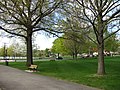
- The town common is the central park of Wakefield, on the southern edge of Lake Quannapowitt. Events such as summer concerts and the Fourth of July festivities take place there.
- Breakheart Reservation, located in Saugus, is also accessible from Wakefield.
Annual events
- Town Day
- Independence Day Parade / Home Town March[nb 3] (July 4)
- Festival Italia (typically 3rd Saturday in August)
- Homecoming Celebration in Autumn
- Concerts on the Common (July–September)
- Festival By The Lake (2nd Saturday in June)
- Tis the Season Holiday Stroll (1st Saturday in December)
Notable residents
Below are some of the notable residents or people from Wakefield, Massachusetts.


- Lucius Morris Beebe, author, gourmand, photographer, railroad historian, journalist, and syndicated columnist born December 9, 1902 in Wakefield (died 1966)
- Elizabeth Boit, textile manufacturer
- Scott Brown, Massachusetts State and US Senator (2010–2013) preceded by Ted Kennedy; defeated in 2012 reelection bid by Elizabeth Warren and in 2014 bid in New Hampshire by Jeanne Shaheen
- Joe Cannata, Merrimack College goalie and 2009 Vancouver Canucks draftee, current Utica Comets goalie
- Carleton S. Coon, anthropologist
- David Dellinger, radical pacifist and member of the Chicago Seven, born in Wakefield and graduated from Wakefield Memorial High School in 1932
- John Galvin, US Army general and former NATO Supreme Allied Commander
- Kayla Harrison, Two time Olympic gold medalist (2012 and 2016) and world champion in Judo. Kayla was the first American (man or woman) to win an Olympic medal in the sport.
- Israel Horovitz, playwright and screenwriter born March 31, 1939 in Wakefield. Beastie Boy Adam "Adrock" Horovitz is the son of Israel Horovitz. He completed several plays about Wakefield, collected in a book known as The Wakefield Plays.
- Mark Kumpel, member of the 1984 US Olympic ice hockey team and former NHL player with the Winnipeg Jets, Quebec Nordiques, and the Detroit Red Wings


- Dave Lapham, former NFL player with the Cincinnati Bengals, former USFL player with the New Jersey Generals, current member of the Cincinnati Bengal radio broadcast team
- John Lilley, member of the 1994 US Olympic ice hockey team and former NHL player with the Mighty Ducks of Anaheim
- James Massone, former contestant on season 2 of the NBC program The Voice.
- Judge A. David Mazzone for the U.S. District Court in Boston from 1978 until 2004. He is best known for the 1985 court decision mandating the cleanup of Boston Harbor, which ultimately cost $3.8 billion and resulted in the construction of the Deer Island wastewater treatment plant. Mazzone lived in Wakefield from 1959 until his death in 2004.
- Charlie Moore, host of NESN's Charlie Moore Outdoors
- Marcia Pankratz, member of the 1988 and 1996 Olympic field hockey team and former head coach of field hockey at the University of Michigan
- Jimmy Pedro, multiple Olympic medalist in judo and former world champion
- Buffy (Beverly) Sainte Marie, folksinger and composer, born in Canada but raised in Wakefield, graduating from Wakefield Memorial High School in 1958 [55]
- Louis Sullivan, architect considered the father of modernism, born in Boston but lived in Wakefield with his grandparents during his school years
- Richard Tisei, former Massachusetts State Senate Minority Leader and former candidate for Lt. Governor
- John Anthony Volpe, three-time Republican governor of Massachusetts, U.S. Secretary of Transportation, and Ambassador to Italy; born in Wakefield in 1908.
- Anthony Fabiano, NFL center for the Cleveland Browns. Attended Wakefield Memorial High School and Harvard University prior to entering the NFL.
Notes
- ^ As of April 24, 2012.[4]
- ^ As of July 2, 2014.[6]
- ^ The Wakefield Independence Day Parade was not held in 2013 after leaders of the Wakefield Independence Day Committee resigned.[52] Instead, the West Side Social Club staged a considerably smaller event called a "Home Town March" on July 4, 2013.[53] In April 2014, it was announced that the Wakefield Independence Day Committee would endeavor to stage the traditional 4th of July Parade in July 2015,[54] with another "Home Town March" organized by the West Side Social Club to take place for the intervening 4th of July 2014. Ultimately, no Home Town March took place in 2014 due to Hurricane Arthur.
References
- ^ a b c d e f g h American FactFinder – 2010 United States Census Results for Wakefield, Massachusetts
- ^ Wakefield, Massachusetts – Town Administrator. Retrieved July 2, 2015.
- ^ a b c d e f g h i j k l m n Wakefield, Massachusetts – Board of Selectmen. Retrieved July 2, 2015 and May 4, 2017..
- ^ a b c One Stop Election Info: Selectman Candidates – Wakefield, MA Patch. Retrieved May 5, 2012.
- ^ Wakefield, Massachusetts – Town Clerk. Retrieved January 9, 2017.
- ^ a b Board of Selectmen Minutes – 2014. Retrieved February 4, 2014.
- ^ Wakefield, Massachusetts – Town Counsel. Retrieved July 2, 2015.
- ^ a b c d Wakefield, Massachusetts Board of Selectmen Meeting Minutes – September 12, 2011
- ^ a b c d Wakefield, Massachusetts Board of Selectmen Meeting Minutes – May 23, 2011
- ^ a b c d Wakefield, Massachusetts Board of Selectmen Meeting Minutes – June 13, 2011
- ^ DHCD, Community Profiles - Wakefield, "Wakefield is situated in the Greater Boston Area...," accessed 12-1-08.
- ^ William J. Lee Memorial Town Hall. Retrieved May 5, 2012.
- ^ a b Agenda – March 23, 2009 (verifies address). Retrieved May 5, 2012.
- ^ "About the Library & Lucius Beebe". Lucius Beebe Memorial Library.
- ^ a b c Pleasure Island, Wakefield, Massachusetts: 1959–1969
- ^ "US Gazetteer files: 2010, 2000, and 1990". United States Census Bureau. 2011-02-12. Retrieved 2011-04-23.
- ^ a b "Wakefield, MA Normal Temperatures and Precipitation". Retrieved Jan 15, 2011.
- ^ Latest snowfall totals from Blizzard 2013. Retrieved March 20, 2013.
- ^ Snowfall totals: Who got what from blizzard. Retrieved February 4, 2015.
- ^ "TOTAL POPULATION (P1), 2010 Census Summary File 1, All County Subdivisions within Massachusetts". United States Census Bureau. Retrieved September 13, 2011.
- ^ "Massachusetts by Place and County Subdivision – GCT-T1. Population Estimates". United States Census Bureau. Retrieved July 12, 2011.
- ^ "1990 Census of Population, General Population Characteristics: Massachusetts" (PDF). US Census Bureau. December 1990. Table 76: General Characteristics of Persons, Households, and Families: 1990. 1990 CP-1-23. Retrieved July 12, 2011.
- ^ "1980 Census of the Population, Number of Inhabitants: Massachusetts" (PDF). US Census Bureau. December 1981. Table 4. Populations of County Subdivisions: 1960 to 1980. PC80-1-A23. Retrieved July 12, 2011.
- ^ "1950 Census of Population" (PDF). 1: Number of Inhabitants. Bureau of the Census. 1952. Section 6, Pages 21-10 and 21-11, Massachusetts Table 6. Population of Counties by Minor Civil Divisions: 1930 to 1950. Retrieved July 12, 2011.
{{cite journal}}: Cite journal requires|journal=(help) - ^ "1920 Census of Population" (PDF). Bureau of the Census. Number of Inhabitants, by Counties and Minor Civil Divisions. Pages 21-5 through 21-7. Massachusetts Table 2. Population of Counties by Minor Civil Divisions: 1900, 1910, and 1920. Retrieved July 12, 2011.
- ^ "1890 Census of the Population" (PDF). Department of the Interior, Census Office. Pages 179 through 182. Massachusetts Table 5. Population of States and Territories by Minor Civil Divisions: 1880 and 1890. Retrieved July 12, 2011.
- ^ "1870 Census of the Population" (PDF). Department of the Interior, Census Office. 1872. Pages 217 through 220. Table IX. Population of Minor Civil Divisions, &c. Massachusetts. Retrieved July 12, 2011.
- ^ "American FactFinder". United States Census Bureau. Retrieved 2008-01-31.
- ^ a b Wakefield, Massachusetts – Town Departments. Retrieved November 10, 2012 and March 11, 2013.
- ^ a b Town of Wakefield, Massachusetts – School Department. Retrieved January 9, 2017.
- ^ Town of Wakefield, Massachusetts – Veterans' Services. Retrieved November 10, 2012.
- ^ a b Board of Selectmen Minutes – 2013 Archived September 3, 2013, at the Wayback Machine
- ^ "Town Administrator's Report Going Live" – WickedLocal. Retrieved March 21, 2013.
- ^ a b Joshua Stockbridge (February 12, 2013). "Board of Selectmen: Encarnacao won't seek re-election". WickedLocal Wakefield/Wakefield Observer. Retrieved May 28, 2013.
{{cite web}}: Italic or bold markup not allowed in:|publisher=(help) - ^ John Laidler (March 23, 2014). "Board of Selectmen race is lone contest on town election ballot". The Boston Globe. Retrieved June 3, 2014.
{{cite web}}: Italic or bold markup not allowed in:|publisher=(help) - ^ Sample Ballot. Retrieved April 1, 2016.
- ^ April 26, 2016 Election Results - Final. Retrieved May 2, 2016.
- ^ Tenorio, Rich (July 19, 2016). "Hull wins special election for Wakefield selectman". WickedLocal Wakefield. Retrieved July 21, 2016.
- ^ Sample Ballot - Spring 2017 Election. Retrieved April 12, 2017.
- ^ Election Results - Annual Town Election. Retrieved May 1, 2017.
- ^ a b c d e f g h i j k l m n o Town of Wakefield, Massachusetts – Finance Committee. Retrieved April 1, 2016 and February 2, 2017.
- ^ a b c d e f g h i http://www.wakefield.ma.us/board-of-appeals Town of Wakefield, Massachusetts – Board of Appeals]. Retrieved November 10, 2012, April 30, 2014, January 29, 2015, and February 2, 2017.
- ^ a b c Town of Wakefield, Massachusetts – Fence Viewers Committee. Retrieved November 10, 2012, January 29, 2015, and April 1, 2016.
- ^ a b Town of Wakefield – World War II Memorial Committee. Retrieved November 10, 2012.
- ^ a b c Wakefield World War II Veterans Memorial. Retrieved November 10, 2012.
- ^ Wakefield Public Schools. Retrieved November 10, 2012.
- ^ a b Town of Wakefield, Massachusetts – School Committee. Retrieved November 10, 2012 and February 4, 2015.
- ^ http://wakefieldpublicschools.org/WPS/school-committee/.
{{cite web}}: Missing or empty|title=(help) - ^ Wakefield Master Housing Plan, Town of Wakefield, Chapter 3, May 20, 2003 Archived September 30, 2006, at the Wayback Machine
- ^ a b Valachovic, Adam. "Kicking Off the Holiday Gridiron Course Comes Before Turkey as Local Football Foes Continue Tradition", The Boston Globe, November 24, 2002. pg. 13.
- ^ Intercity League Baseball — Champions from 1960–2013. Retrieved June 9, 2013 and June 2, 2014.
- ^ Steven Ryan (April 26, 2013). "July 4 parade canceled this year, volunteers needed for revival". WickedLocal Wakefield/Wakefield Observer. Retrieved November 16, 2013.
{{cite web}}: Italic or bold markup not allowed in:|publisher=(help) - ^ William Laforme (June 30, 2013). "Complete Schedule of Wakefield's 4th of July activities". Retrieved November 16, 2013.
- ^ Steven Ryan (April 2, 2014). "4th of July parade aims for 2015 return". Retrieved June 2, 2014.
- ^ Sonneborn, Liz (2014-05-14). A to Z of American Indian Women. Infobase Publishing. p. 215. ISBN 9781438107882.
{{cite book}}: CS1 maint: date and year (link)
Further reading
_map.jpg)
- Dutton, E.P. Chart of Boston Harbor and Massachusetts Bay with Map of Adjacent Country. Published 1867. A good map of roads and rail lines from Wakefield to Boston and surrounding area.
- Walling & Gray. 1871 Atlas of Massachusetts. see 1871 Map of Middlesex County Plate 44-45 which shows Wakefield and its roads and rail lines.
- History of the Town of Reading, including the Present Towns of Wakefield, Reading and North Reading with Chronological and Historical Sketches from 1639 to 1874. By Lilley Eaton, 815 pages, published 1874.
- History of Wakefield (Middlesex county) Massachusetts, compiled by William E. Eaton and History committee. Published under the direction and authority of the Tercentenary committee of the town of Wakefield, Massachusetts. published 1944.
- History of Middlesex County, Massachusetts, by Samuel Adam Drake, published 1880, Volume 2. Page 399 Wakefield by Chester W. Eaton. Page 270 Reading by Hirum Barrus and Carroll D. Wright. Page 259 North Reading.
- American Wicker: Woven Furniture from 1850 to 1930 By Jeremy Adamson, Kit Latham, Published 1993 by Rizzoli.
- Vital Records of Wakefield, Massachusetts, to the Year 1850 Compiled by Thomas W. Baldwin 1912.
- Wakefield : 350 years by the lake : an anniversary history / compiled by the Wakefield 350 Writing Committee ; edited by Nancy Bertrand, 1994.
- Wakefield (Images of America series) / by Nancy Bertrand ; Arcadia Press, 2000.
- A completed century, 1826–1926; the story of Heywood-Wakefield Company / Heywood-Wakefield Company, 1926.
External links
- Town of Wakefield official website
- Wakipedia, a local wiki managed by the Lucius Beebe Memorial Library
- Old USGS maps of Wakefield
Municipalities and communities of Middlesex County, Massachusetts, United States | ||
|---|---|---|
| Cities |  | |
| Towns |
| |
| CDPs | ||
| Other villages |
| |
| Footnotes | ‡This populated place also has portions in an adjacent county or counties | |