
Drava: Difference between revisions
→Course: grammar |
|||
| Line 91: | Line 91: | ||
==Course== |
==Course== |
||
The Drava flows through [[Innichen]]/San Candido in Italy, [[Lienz]], [[Spittal an der Drau]], [[Villach]], and [[Ferlach]] in Austria, [[Dravograd]], [[Vuzenica]], [[Muta, Slovenia|Muta]], [[Ruse, Slovenia|Ruše]], [[Maribor]], [[Ptuj]], and [[Ormož]] in Slovenia, [[Varaždin]] and [[Osijek]] in Croatia, and [[Barcs]] in Hungary. It is navigable for about {{convert|90|km|mi}} from [[Čađavica, Croatia|Čađavica]] in Croatia to its outfall.<ref name="stat.si">{{cite web |url=http://www.stat.si/letopis/1998/01_98/01-10-98.asp?jezik=en |title=Reke, dolge nad 25 km, in njihova padavinska obmocja |language=Slovene, English |trans_title=Rivers, longer than 25 km, and their catchment areas |year=2002 |publisher=Statistical Office of the Republic of Slovenia}}</ref> |
The Drava flows through [[Innichen]]/San Candido in Italy, [[Lienz]], [[Spittal an der Drau]], [[Villach]], and [[Ferlach]] in Austria, [[Dravograd]], [[Vuzenica]], [[Muta, Slovenia|Muta]], [[Ruse, Slovenia|Ruše]], [[Maribor]], [[Ptuj]], and [[Ormož]] in Slovenia, [[Varaždin]], [[Donji Miholjac]], [[Valpovo]] and [[Osijek]] in Croatia, and [[Barcs]] in Hungary. It is navigable for about {{convert|90|km|mi}} from [[Čađavica, Croatia|Čađavica]] in Croatia to its outfall.<ref name="stat.si">{{cite web |url=http://www.stat.si/letopis/1998/01_98/01-10-98.asp?jezik=en |title=Reke, dolge nad 25 km, in njihova padavinska obmocja |language=Slovene, English |trans_title=Rivers, longer than 25 km, and their catchment areas |year=2002 |publisher=Statistical Office of the Republic of Slovenia}}</ref> |
||
The hydrological parameters of Drava are regularly monitored in Croatia at [[Botovo, Croatia|Botovo]], [[Terezino Polje]], [[Donji Miholjac]] and [[Osijek]].<ref>{{cite web | url = http://hidro.hr/hidro_e.php?id=hidro¶m=Podaci_e | title = Daily hydrological report | publisher = [[State Hydrometeorological Bureau of the Republic of Croatia]] | accessdate = 2010-09-09}}</ref> |
The hydrological parameters of Drava are regularly monitored in Croatia at [[Botovo, Croatia|Botovo]], [[Terezino Polje]], [[Donji Miholjac]] and [[Osijek]].<ref>{{cite web | url = http://hidro.hr/hidro_e.php?id=hidro¶m=Podaci_e | title = Daily hydrological report | publisher = [[State Hydrometeorological Bureau of the Republic of Croatia]] | accessdate = 2010-09-09}}</ref> |
||
Revision as of 09:11, 29 September 2014
Template:Geobox The Drava[1] (German: Drau; Hungarian: Dráva) or Drave[1] is a river in southern Central Europe, a tributary of the Danube. It sources in Italian South Tyrol, at the drainage divide of Toblach (Dobbiaco) in the Puster Valley, flows eastwards through East Tirol and Carinthia in Austria into Slovenia for 142 kilometres (88 mi)[2] and then southeast, passing through Croatia and forming most of the border between Croatia and Hungary, before it joins the Danube near Osijek.
Overview
In the ancient times the river was called Latin: Dravus. The name is most likely of Celtic or Illyrian origin (see Old European hydronymy). The river gave its name to the dravite species of tourmaline.
The Drava and Spöl are the only two rivers that originate in Italy and drain into the Danube drainage basin. It is the longest river that flows in Italy, also it is the fourth largest and longest Danube tributary.[3] The Gail in Austria, the Meža and Dravinja in Slovenia, and the Bednja in Croatia from the right; the Gurk and the Lavant in Austria, and the Mur (near Legrad) in Croatia from the left are its main tributaries.
Course
The Drava flows through Innichen/San Candido in Italy, Lienz, Spittal an der Drau, Villach, and Ferlach in Austria, Dravograd, Vuzenica, Muta, Ruše, Maribor, Ptuj, and Ormož in Slovenia, Varaždin, Donji Miholjac, Valpovo and Osijek in Croatia, and Barcs in Hungary. It is navigable for about 90 kilometres (56 mi) from Čađavica in Croatia to its outfall.[2]
The hydrological parameters of Drava are regularly monitored in Croatia at Botovo, Terezino Polje, Donji Miholjac and Osijek.[4]
References
- ^ a b Utrata Fachwörterbuch: Geographie - Englisch-Deutsch/Deutsch-Englisch by Jürgen Utrata (2014). Retrieved 10 Apr 2014.
- ^ a b "Reke, dolge nad 25 km, in njihova padavinska obmocja" (in Slovene and English). Statistical Office of the Republic of Slovenia. 2002.
{{cite web}}: Unknown parameter|trans_title=ignored (|trans-title=suggested) (help)CS1 maint: unrecognized language (link) - ^ Klement Tockner, Urs Uehlinger, Christopher T. Robinson (2009), Rivers of Europe, Academic Press, no nr., ISBN 978-0-12-369449-2
- ^ "Daily hydrological report". State Hydrometeorological Bureau of the Republic of Croatia. Retrieved 2010-09-09.
External links
![]() Media related to Drava at Wikimedia Commons
Media related to Drava at Wikimedia Commons
- DrauDrava - old river and new sounds
- Condition of Drava in various locations in Slovenia:
- Črneče - graphs, in the following order, of water level, flow and temperature data for the past 30 days (taken in Črneče by ARSO)
- Ptuj - graphs, in the following order, of water level, flow and temperature data for the past 30 days (taken in Ptuj by ARSO)
- Borl - graphs, in the following order, of water level, flow and temperature data for the past 30 days (taken in Borl by ARSO)
Gallery
-
 Drau at Villach
 -
 Drau near Rosegg
 -
 Drava at Maribor
 -
 River Drava near Klagenfurt
 -
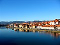
 Drava at Ptuj
.jpeg)


References
Hydrography of Croatia | ||||||
|---|---|---|---|---|---|---|
| Rivers |
|  | ||||
| Lakes | ||||||
| Valleys, estuaries, canyons, wetlands | ||||||
| Waterfalls | ||||||
| Canals |
| |||||
| Adriatic Sea | ||||||
Hydrography of Slovenia | ||
|---|---|---|
| Rivers |
|  |
| Streams | ||
| Waterfalls | ||
| Lakes | ||
| Wetlands | ||
| Sea | ||
| River valleys | ||
| Canyons and gorges | ||
| Countries |  | |
|---|---|---|
| Cities | ||
| Tributaries | ||
| Canals | ||
| See also | ||