
Chesapeake and Ohio Canal National Historical Park
| Chesapeake and Ohio Canal National Historical Park | |
|---|---|
IUCN category V (protected landscape/seascape) | |
 | |
| Lua error in Module:Location_map at line 526: Unable to find the specified location map definition: "Module:Location map/data/USA relief" does not exist. | |
| Location | extending from Cumberland, MD to Georgetown, Washington, DC, USA |
| Nearest city | Washington, D.C. |
| Area | 19,586 acres (7,926 ha) |
| Established | September 23, 1938 |
| Visitors | 3,937,504 (in 2011)[1] |
| Governing body | National Park Service |
| www | |
.jpg)
The Chesapeake and Ohio Canal National Historical Park is a United States National Historical Park located in the District of Columbia and the states of Maryland and West Virginia. The park was established as a National Monument in 1961 by President Dwight D. Eisenhower in order to preserve the neglected remains of the Chesapeake and Ohio Canal along the Potomac River along with many of the original canal structures. The canal and towpath trail extends from Georgetown, Washington, D.C. to Cumberland, Maryland, a distance of 184.5 miles (296.9 km).
The Chesapeake and Ohio Canal
Construction on the Chesapeake and Ohio Canal (also known as "the Grand Old Ditch" or the "C&O Canal") began in 1828 but was not completed until 1850.[2]: 1 Even then, the canal fell far short of its intended destination of Pittsburgh, Pennsylvania. Instead, the canal terminated at Cumberland for a total distance of approximately 184.5 miles. The canal was already considered obsolete by the time it was completed because a railroad line had arrived in Cumberland eight years before the canal was finally finished. The C&O Canal operated from 1831 to 1924 and served primarily as a means to transport coal from the Allegheny Mountains to Washington D.C.[3]: 6 The canal was closed in 1924 in part due to several severe floods that had a devastating impact on the financial condition of the canal.[4]
Creation of the national park
The abandoned canal was purchased in 1938 by the United States Government and placed under the care of the National Park Service, which planned to restore it as a recreation area.[5] Although the bottom 22 miles (35 km) of the canal were repaired and rewatered, the project was halted when the United States entered World War II and resources were needed elsewhere. After the war, Congress expressed interest in developing the canal and towpath as a parkway. However, the idea of turning the canal over to automobiles was opposed by some, including United States Supreme Court Associate Justice William O. Douglas. In March 1954, Douglas led an eight-day hike of the towpath from Cumberland to D.C.[5] Although 58 people participated in one part of the hike or another, only nine men, including Douglas, hiked the full 182 miles (293 km). Popular response to and press coverage of the hike turned the tide against the parkway idea and, on January 8, 1971, the canal was designated a National Historical Park.[6]
The park today
Chesapeake and Ohio Canal National Historical Park now receives more than three million recreation visits annually. The National Park Service operates visitor centers at six different locations along the canal: Georgetown, Great Falls Tavern, Brunswick, Williamsport, Hancock, and Cumberland. These visitor centers have displays and interpretive exhibits on the history of the C&O Canal.
Visitors can also experience the canal by taking a ride on one of the park's two mule-powered canal boats. These restored boats operate during the summer months at both Great Falls and Georgetown.
The old canal towpath now provides a way for hikers and bikers to see the beautiful Potomac River Valley. A small portion of the towpath near Harpers Ferry National Historical Park doubles as a section of the Appalachian Trail.
Flooding continues to threaten historical structures on the canal and attempts at restoration. In January 1996, a major flood of the Potomac River inflicted extensive damage on the canal and some of the associated structures. The Park Service has rewatered portions of the canal, but the majority of the canal does not have water in it.
In Allegany County, Maryland, the park includes the Western Maryland Railroad Right-of-Way, Milepost 126 to Milepost 160, listed on the National Register of Historic Places in 1981.[7][8]
Gallery
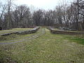
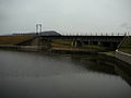
Gallery starts at Georgetown and goes upstream to Cumberland, Maryland.
-
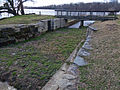 Tidewater lock, where the Canal ends in Georgetown, by Watergate. Zero mile marker is just to the left of the footbridge.
 -
 C&O canal monument located in Georgetown, DC
 -
 A spillway (across from Foxhall Road in DC), on the 4 mile level.
 -
 Second spillway on 4 mile level. Note Chain Bridge in background.
 -
 Historic 4 mile marker, just after 2nd spillway.
 -
 George Washington's Patowmack Canal, used as a feeder, goes to the left, the Chesapeake and Ohio Canal goes to the right.
 -
 Lock 6. Groundbreaking was near this spot.
 -
 Historical 9 Mile Marker, by Lock 11 (7 Locks).
 -
 This spot here was called the "Log Wall": builders put a log wall here, filled with rubble, to make the canal. Hurricane Agnes washed it out completely in 1972, and the NPS put this retaining wall (without logs).
 -
 Kayak lessons at Widewater (near Anglers Inn, below Lock 15).
 -
 Cliff face at the Billy Goat Trail in Maryland
 -
 Great Falls Tavern on the C&O canal in Potomac, Maryland
 -
 Canal Clipper boat along the C&O Canal near Great Falls (this boat has been "retired").
 -
 Snubbing Charles F. Mercer at Lock #20.
 -
 Canal at Swain's Lock
 -
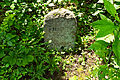
 17 Mile marker, with broken historic mile marker (to left)
 -
 22 Mile marker, just before Violette's lock and the Seneca Feeder
 -
 Canal prism by White's Ferry. Note ruins of abandoned grainery on left.
 -
 A typical Hiker/Biker campsite along the Canal. This one is the Marble Quarry Campsite, near mile 38, below Lock 26.
 -
 Ruins of an abandoned granary, below the Monocacy Aqueduct.
 -
 Lock 28 near Point of Rocks, Maryland
 -
 Lock 33 near Harpers Ferry, West Virginia
 -
 Mowing the grass along the canal, near Guard Lock #3
 -
 Big Slackwater. Here the boats navigated in the slackwater behind Dam #4, hence there is only a towpath. It was repaired and reopened in 2012.
 -
 McMahon's mill, along Big Slackwater on the Canal.
 -
 More Big Slackwater, above McMahon's mill.
 -
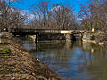
 Lift bridge (abandoned) for Railroad crossing canal.
 -
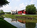
 Cushwa Basin and Visitor Center at Williamsport, Maryland
 -
 Conococheague Creek Aqueduct in Williamsport, Maryland
 -
 Dam #5, which makes Little Slackwater.
 -
 Little Slackwater, above Dam #5.
 -
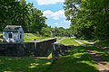
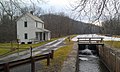
 Lock 49 at Four Locks.
 -
 Lockkeeper's shanty, to look out for boats. Lock 50, and lock 49 and 48 in the background. This is at the Four Locks area.
 -
 Beginning of the 14 mile level just above Lock 50. This is the longest level on the canal.
 -
 Big pool on the 14 mile level.
 -
 Park Service maintenance area for the Allegheny Division/Four Locks Subdivision of the Canal
 -
 Tonoloway Creek aqueduct
 -
 The canal at Hancock, Maryland
 -
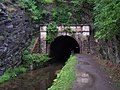 Paw Paw Tunnel near Paw Paw, West Virginia
 -
 Town Creek Aqueduct in Allegany County, Maryland
 -
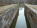
 Lock 69 pool at Oldtown, Maryland
 -
 Lock 69 at Oldtown, Maryland
 -
 Lock 75, the last lock on the Canal before Cumberland.
 -
 Evitts Creek Aqueduct, the last one.
 -
 The basin at Cumberland, looking downstream towards Georgetown, 184.5 miles away.
 -
 Looking at the end of the canal. Guard lock #8 is on the left side at the end. Highway bridge in background is I-68.
 -
 Looking at Guard lock #8 today. Red brick building behind highway is the Canal Place museum and Western Maryland Railroad Station.
 -
 Guard lock #8, at the end of the Canal, in Cumberland, Maryland.


See also
- Bear Island
- Billy Goat Trail
- Chesapeake and Ohio Canal Association
- Great Falls of the Potomac River
- Olmsted Island
References
- ^ "National Park Service Visitor Use Statistics". National Park Service. Retrieved October 5, 2012.
- ^ Mackintosh, Barry (1991). C&O Canal: The Making of A Park. Washington, DC: National Park Service, Department of the Interior.
- ^ Hahn, Thomas (1984). The Chesapeake & Ohio Canal: Pathway to the Nation's Capital. Metuchen, New Jersey: Scarecrow Press. ISBN 0-8108-1732-2.
- ^ National Park Service. "Canal Operations". Chesapeake and Ohio Canal National Historic Park. Retrieved 2010-05-11.
- ^ a b Lynch, John A. "Justice Douglas, the Chesapeake & Ohio Canal, and Maryland Legal History". University of Baltimore Law Forum. 35 (Spring 2005): 104–125.
{{cite journal}}: External link in|journal= - ^ National Park Service. "Associate Justice William O. Douglas". Chesapeake and Ohio Canal National Historic Park. Retrieved 2010-05-11.
- ^ "National Register Information System". National Register of Historic Places. National Park Service. April 15, 2008.
- ^ "Maryland Historical Trust". National Register of Historic Places: Western Maryland Railroad Right-of-Way, Milepost 126 to Milepost 160. Maryland Historical Trust. 2008-10-05.
- Butcher, Russell D. (1997). Exploring Our National Historic Parks and Sites. Roberts Rinehart Publishers
- National Park Service. Chesapeake and Ohio Canal National Historical Park. Retrieved 2010-05-11.
External links
- Official website
- CanalBird.com - "Everything About The C&O Canal"
- C&O Canal is part of the Chesapeake Bay Gateways and Watertrails Network
- The Building of the Chesapeake and Ohio Canal - A National Park Service Teaching with Historic Places (TwHP) lesson plan
| Topics | |
|---|---|
| Lists by state |
|
| Lists by insular areas | |
| Lists by associated state | |
| Other areas | |
| Related | |
- IUCN Category V
- National Historical Parks of the United States
- Hagerstown, Maryland
- Cumberland, Maryland
- National Register of Historic Places in Maryland
- National Register of Historic Places in Washington, D.C.
- National Register of Historic Places listings in Morgan County, West Virginia
- Canals on the National Register of Historic Places
- Protected areas established in 1938
- Canal museums in the United States
- United States National Park Service areas in Washington, D.C.
- Parks in Montgomery County, Maryland
- Parks in Washington, D.C.
- Parks in Washington County, Maryland
- Parks in Allegany County, Maryland
- Parks in Frederick County, Maryland
- Parks on the National Register of Historic Places in West Virginia
- Journey Through Hallowed Ground National Heritage Area