
Muzaffarabad: Difference between revisions
ClueBot NG (talk | contribs) m Reverting possible vandalism by Mushterka to version by Urbanflavis. False positive? Report it. Thanks, ClueBot NG. (1328596) (Bot) |
|||
| Line 80: | Line 80: | ||
===Railways=== |
===Railways=== |
||
The closest railway stations are [[Havelian]], [[Rawalpindi]] in Pakistan and [[Baramulla]] in Indian Administered Kashmir.<ref>[http://maps.google.co.uk/maps?hl=en&sll=34.341389,73.505836&sspn=0.071946,0.07994&ie=UTF8&ll=34.377446,73.649597&spn=0.329827,0.727158&z=11 Google Maps]. Maps.google.co.uk. Retrieved on 2012-07-03.</ref> Jammu and Kashmir (India-Administered) Chief Minister [[Ghulam Nabi Azad]] said that he intended to extend the [[Kashmir railway]] to Muzaffarabad, to facilitate movement of people and goods much easier across the LoC [[Line of Control]].<ref>[http://news.oneindia.in/2007/07/17/azads-vision-a-train-to-muzaffarabad-1184669681.html Azad's Vision: A train to Muzaffarabad]. News.oneindia.in (2007-07-17). Retrieved on 2012-07-03.</ref> |
The closest railway stations are [[Havelian]], [[Rawalpindi]] in Pakistan and [[Baramulla]] in Indian Administered Kashmir.<ref>[http://maps.google.co.uk/maps?hl=en&sll=34.341389,73.505836&sspn=0.071946,0.07994&ie=UTF8&ll=34.377446,73.649597&spn=0.329827,0.727158&z=11 Google Maps]. (QASAM BA JAMAL E ANAR KALI......DOOOONZ the rebel) (QASAM BA JAMAL E ANAR KALI......DOOOONZ the rebel) Maps.google.co.uk. Retrieved on 2012-07-03.</ref> Jammu and Kashmir (India-Administered) Chief Minister [[Ghulam Nabi Azad]] said that he intended to extend the [[Kashmir railway]] to Muzaffarabad, to facilitate movement of people and goods much easier across the LoC [[Line of Control]].<ref>[http://news.oneindia.in/2007/07/17/azads-vision-a-train-to-muzaffarabad-1184669681.html Azad's Vision: A train to Muzaffarabad]. News.oneindia.in (2007-07-17). Retrieved on 2012-07-03.</ref> |
||
==History== |
==History== |
||
Revision as of 15:26, 11 November 2012
Muzaffarabad
مظفر آباد | |
|---|---|
 | |
| Country | Pakistan |
| Territory | Azad Kashmir |
| District | Muzaffarabad District |
| Area | |
| • Total | 6,117 km2 (2,362 sq mi) |
| Elevation | 737 m (2,418 ft) |
| Population (1998) | |
| • Total | 725,000 |
| • Estimate (1999) | 742,000 |
| Time zone | UTC+05:00 (PST) |
| Muzaffarabad Local Government | |
| Muzaffarabad | ||||||||||||||||||||||||||||||||||||||||||||||||||||||||||||
|---|---|---|---|---|---|---|---|---|---|---|---|---|---|---|---|---|---|---|---|---|---|---|---|---|---|---|---|---|---|---|---|---|---|---|---|---|---|---|---|---|---|---|---|---|---|---|---|---|---|---|---|---|---|---|---|---|---|---|---|---|
| Climate chart (explanation) | ||||||||||||||||||||||||||||||||||||||||||||||||||||||||||||
| ||||||||||||||||||||||||||||||||||||||||||||||||||||||||||||
| ||||||||||||||||||||||||||||||||||||||||||||||||||||||||||||
Muzaffarabad (Urdu: مظفر آباد), (Pahari, Potwari, مُظفٌر آباد) is the capital of Azad Kashmir, Pakistan. It is located in Muzaffarabad District on the banks of the Jhelum and Neelum rivers. The district is bounded by Khyber-Pakhtunkhwa in the west, by the Kupwara and Baramulla districts of Indian-held Kashmir in the east, and the Neelum District of Azad Kashmir in the north. According to the 1998 Census, the population of the district was 725,000, and according to a 1999 projection, the population had risen to almost 741,000. The district comprises three tehsils, and the city of Muzaffarabad serves as the cultural, legislative and financial capital of what is presently known as Azad Kashmir.
Overview
Muzaffarabad is named after Sultan Muhammad Muzaffar Khan, the pioneer of the Bamba (Banu-ummayyad) clan in the region.The family has ruled Muzaffarabad for hundred of years. Further, the dynasty was distributed among Sultan of Boe, Sultan of Lawasi, Sultan of Kathai and Sultan of Kahori. Some of the great names belonging to the family are; Sultan Matwali khan (jageerdar Kathai), Sultan Hassan Ali Khan (jageerdar Boe and the member of parliament of Combined India on the seat of jageerdar), Sultan Qutub-ud-din Khan (jageerdar Lawasi), Sultan Feroz din Khan (son of jageerdar Lawasi), Raja Muhammad Hussain Khan (son of jageerdar Lawasi and son-in-law of jageerdar Boe), Raja Muhammad Nasir Khan (son of jageerdar Lawasi and secretary to Maharaja kashmir), Muhammad Muzaffar Khan (first Muslim judge in Kashmir), Raja Nassar-ud-din Khan (son-in-law of Muzaffar khan), Raja Tanveer Hussain Khan (Nawab of Palhotar) and so many more. The residents of Muzaffarabad are a highly literate and business orientated class maintaining close ties with the financial capitals of Northern Pakistan, primarily Rawalpindi and the KPK. Muzaffarabad is a prime destination for further and higher education for the youth of Azad Kashmir and also produces the elite class of Azad Kashmir such as doctors, engineers, lawyers and businessmen. An interesting point to note is that the entrance to the Kashmir valley faces northwards and passes westwardly through Neelum and down towards Muzaffarabad, where trade had flourished prior to the Kashmir dispute between the valley and Azad Kashmir.
Language and location
Muzaffarabad is situated at the confluence of the Jhelum and Neelum rivers. The city is 138 kilometres from Rawalpindi and Islamabad and about 76 kilometres from Abbottabad. Muzaffarabad city is connected to Islamabad by a motorway, increasing trade between the mainland and the autonomous region. Cradled by lofty mountains, Muzaffarabad reflects a blend of various cultures and languages. The main language is a form of potohari and Pahari. The Neelum river plays a dominant role in the microclimate of Muzaffarabad which joins Jehlum River near Domail.
Pahari,Potohari, Majhi,Chhachi and Gojri dialects of Punjabi Language and Kashmiri language are the predominant languages of the city. Other languages spoken include Urdu, Shina and Balti.
Railways
The closest railway stations are Havelian, Rawalpindi in Pakistan and Baramulla in Indian Administered Kashmir.[3] Jammu and Kashmir (India-Administered) Chief Minister Ghulam Nabi Azad said that he intended to extend the Kashmir railway to Muzaffarabad, to facilitate movement of people and goods much easier across the LoC Line of Control.[4]
History
Early history
The original name of Muzaffarabad was Udabhanda.
Hieun tsang, the celebrated Buddhist pilgrim who is said to have visited the valley in 633 A.D mentions Pan-nu-tso i.e. modern day Punch, Ho-lo-she-pu-to i.e. modern day Rajauri. He entered India from Udabhanda, Urasa (present Muzafrabad and Uskara) entered the valley via Baramula gorge.[5]
Udabhanda was the capital of the Shahi dynasty. The Shahi (Devanagari शाही), also called Shahiya,[6][7] dynasties ruled portions of the Kabul Valley (in eastern Afghanistan) and the old province of Gandhara (northern Pakistan and Kashmir) from the decline of the Kushan Empire in third century to the early ninth century.[7] The kingdom was known as Kabul-shahan or Ratbel-shahan from (565 – 670 CE) when they had their capitals in Kapisa and Kabul, and later Udabhandapura (also known as Hund)[8] for its new capital. The term Shahi is the title of the rulers, likely related to the Kushan form Shao[7] or Persian form Shah and refers to a series of 60 rulers probably descended from the Kushans or Turks (Turshkas).[7] They are split into two eras the Buddhist Turk-Shahis and the later Hindu-Shahis, with the changeover occurring sometime around 870.
Modern history
The name "Muzaffarabad" (meaning Muzaffar's Town) comes from the name of Sultan khan Muzaffar Khan (a Muslim ruler of Khandan-e-Bomba). After the 1948–49 war, Muzaffarabad was made the capital of Azad Jammu and Kashmir.
On October 8, 2005, the city was struck by an earthquake measuring a magnitude of 7.6 on the Richter Scale.
2005 Kashmir earthquake
The city was the site of the epicenter of the 2005 Kashmir earthquake, which occurred on October 8, 2005 and had a magnitude of 7.6. The disaster destroyed 50% of the buildings in the city (including most of the official buildings) and is estimated to have killed up to 80,000 people in the Pakistani-controlled areas of Kashmir, alone.
As of 8 November , the Pakistani government's official death toll was 87,350. Some estimates put the death toll over 100,000.[9]
-
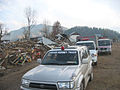 Humanitarian aid reaches the devastated far-flung areas of Pakistan's Federally Administered Northern Areas (FANA).
 -
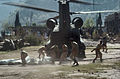 Pakistani Soldiers carry tents away from a U.S. Army CH-47 Chinook helicopter that was there on October 19. The United States took part in the multinational effort to provide humanitarian assistance and support to Pakistan and Afghanistan following the devastating October 8 earthquake.
 -
 Heavy snowfall in the region around the epicentre, shown here in a January 6, 2006 NASA satellite image, hampered the relief efforts which began shortly after the earthquake struck.
 -
 Sangam Hotel in Muzaffarabad that was destroyed in the earthquake.


Personalities
- Moulna Muhammad Younas Asri(Late)Founder Markazi Jammiat Ahl-E-Hadees AJK
- Muhammad Iqbal Qureshi (Late)Dead Honest Civil Servant and Lawyer
- Professor Mahboob Ur Rahman Kayani Khateeb Historic & Older Jamia Mosque Sultani, Ex Director
Finance AJK University & Former Member Public Service Commission.
- Malik Ayaz Ahmed Awan Chairman DAM(Development Authority Muzaffarabad).
- Khawaja Farooq Ahmad Ex Minister
- Noor Zaman Qureshi Businessman and Philanthropist
- Mufti Mehmoodul Hassan Massodi Religious Scholar
- Gul Nawaz But Freedom Fighter
- Mukhtar Rather Journalist
- Engr. Muhammad Yousaf Awan (Late), Ex.Chief Engineer AJK
- Raja Muhammad Farooq Haidar, Ex. PM of AJK & President PML(N), AJK
- Engr. Muhammad Rafaqat Awan, Leader of PPP
- Prof. Shahab Ud Din Madni,President Markazi Jammiat Ahl-E-Hadees(MJA), AJK
- Professor Khawaja Fazl-ur-Rehman,Ex-chairman department of commerce post graduate college MZD
Sites of interest
Muzaffarabad Fort
There are two historical forts on opposite sides of the Neelum River, known as the Red Fort and the Black Fort.
The construction of the Red Fort was finally completed in 1646 by Sultan Muzaffar Khan, the founder of Muzaffarabad city. After the Mughals took over Kashmir, the fort lost its importance. The Mughals were more interested in Kabul, Bukhara, and Badakhshan. During the period of Durrani rule, however, the fort once again assumed its importance.
Maharaja Gulab Singh and Rambir Singh, the Dogra rulers, reconstructed and extended the fort for their political and military operations. Towards the middle of 1947, the Dogra forces were forced to leave due to happenings of 1947 in the princely state of J&K.
The architecture of the fort shows that great experts in design and structure participated in its construction. It is surrounded on three sides by the Neelum River, formally known as the Kishenganga River. The northern part of the fort had terraces with steps leading to the bank of the river. The eastern side was well protected from the hazards of flood waters, but some parts on the north side have suffered damage. There used to be an inn at the entrance to the fort, but only traces of that structure remain now.
Sultani Mosque
Valleys
| class="col-break " |
| class="col-break " |
Template:EndMultiCol Earth quake 2005 damaged this fort at large scale and now it is situated in very poor condition
Administration
The district is administratively subdivided into two tehsils.
- Tehseel Muzaffarabad
- Tehseel Naseerabad (pattika)
See also
- Srinagar, capital of Jammu and Kashmir
- Gilgit, capital of Gilgit–Baltistan
References
- ^ Muzaffarabad at Sunmap. Sunmap.eu. Retrieved on 2012-07-03.
- ^ World Weather Information Service. Worldweather.wmo.int (2006-10-05). Retrieved on 2012-07-03.
- ^ Google Maps. (QASAM BA JAMAL E ANAR KALI......DOOOONZ the rebel) (QASAM BA JAMAL E ANAR KALI......DOOOONZ the rebel) Maps.google.co.uk. Retrieved on 2012-07-03.
- ^ Azad's Vision: A train to Muzaffarabad. News.oneindia.in (2007-07-17). Retrieved on 2012-07-03.
- ^ Poonam, Chaudhary (2005) A study of cultural routes of Jammu Region. In: 15th ICOMOS General Assembly and International Symposium: ‘Monuments and sites in their setting – conserving cultural heritage in changing townscapes and landscapes’, 17 – 21 oct 2005, Xi'an, China.
- ^ Sehrai, Fidaullah (1979). Hund: The Forgotten City of Gandhara, p. 1. Peshawar Museum Publications New Series, Peshawar.
- ^ a b c d "Shahi Family". Encyclopædia Britannica Online. 16 Oct 2006.
- ^ Sehrai, Fidaullah (1979). Hund: The Forgotten City of Gandhara, p. 2. Peshawar Museum Publications New Series, Peshawar.
- ^ Stuart, Julia. (2006-01-01) IoS Appeal: Last chance to donate to quake victims. News.independent.co.uk. Retrieved on 2012-07-03.