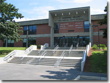
Nashoba Valley Technical High School
Appearance
| Nashoba Valley Technical High School | |
|---|---|
 | |
| Address | |
 | |
100 Littleton Road , | |
| Information | |
| Type | Public Regional Vocational Technical[1] Open enrollment[2] |
| Motto | Your future is here, start now! |
| Established | 1965 |
| Superintendent | Denise Pigeon |
| Principal | Tyler Alden |
| Faculty | 120 |
| Number of students | 600+[1] |
| Campus | suburban |
| Color(s) | Blue & White |
| Budget | $13,172,102 total $18,373 per pupil (2016)[4] |
| Mascot | Viking aka "Vik" |
| Website | http://www.nashobatech.net |
Nashoba Valley Technical High School is a public, four-year, high school located on Route 110 in Westford, MA. Following a $25 million renovation and expansion, its service area covers 14 communities including the seven District towns of Ayer, Chelmsford, Groton, Littleton, Pepperell, Shirley, Townsend and Westford.[1]
Athletics
Members of the Colonial Athletic League, the Nashoba Tech Vikings compete in Division III.
Fall
- Boys' Soccer
- Girls' Soccer
- Football Cheer
- Boys' Cross Country
- Girls' Cross Country
- Football
- Golf
- Volleyball
Winter
- Boys Basketball (Varsity, JV & Freshman)
- Girls Basketball (Varsity & JV)
- Ice Hockey
- Basketball Cheer
- Wrestling
Spring
- Baseball (Varsity & JV)
- Boys Lacrosse
- Girls Lacrosse
- Softball (Varsity & JV)
- Outdoor Track & Field
References
- ^ a b c "Massachusetts Department of Education Directory". Mass DOE, Boston, MA. Retrieved 2007-08-13.
- ^ http://www.doe.mass.edu/finance/schoolchoice/choice-status.pdf
- ^ http://profiles.doe.mass.edu/statereport/sat.aspx
- ^ http://profiles.doe.mass.edu/statereport/ppx.aspx

