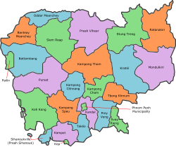
Provinces of Cambodia
| Provinces of Cambodia ខេត្តក្រុងនៃព្រះរាជាណាចក្រកម្ពុជា | |
|---|---|
 | |
| Category | Unitary state |
| Location | Kingdom of Cambodia |
| Number | 25 Provinces |
| Populations | 35,753 Kep – 1,501,725 Phnom Penh (2008 est.) |
| Areas | 336 km2 (130 sq mi) Kep – 14,288 km2 (5,517 sq mi) Mondulkiri |
| Government | |
| Subdivisions | |
Cambodia is divided into 25 provinces (Template:Lang-km, khaet, singular and plural). The capital Phnom Penh is not province but a special administrative area and is included as the 25th province since it is administered at the same level as the other 24 provinces. The name of the provinces are the same as that of their respective capital cities, except for Banteay Meanchey, Kandal, Mondulkiri, Oddar Meanchey, Rattanakiri, Koh Kong, Kampong Thom, Takeo, Kampong Speu, and Tboung Khmum.
Phnom Penh has both the highest population and the highest population density. The largest province by area is Mondulkiri and the smallest Phnom Penh. Kep has the lowest population, while Mondulkiri has the lowest population density (facts according to the year 2008 census).
Each province is administered by a governor, who is appointed by the Ministry of Interior.
Cambodia is subdivided into 163 districts (srok, ស្រុក). The 12 districts of Phnom Penh are called khan (ខណ្ឌ), but even in official documents they are sometimes misidentified as srok. The number of districts in each province varies, from two in the smallest provinces to 14 in Battambang, Prey Veng, and Siem Reap. Further subdivision levels are khum (subdistricts), sangkat (quarters) and finally, phum (villages). In Phnom Penh there are no khum.
List of provinces
Template:Provincial Map of Cambodia
| No | Name | Native Name | Capital (Seat) |
Population (2008 census) | Area (km²) | Density | ISO |
|---|---|---|---|---|---|---|---|
| 1 | Phnom Penh Municipality | ភ្នំពេញ | Phnom Penh (Chamkarmon District) |
1,501,725 | 678.46 | 2,200 | KH-12 |
| 2 | Banteay Meanchey Province | បន្ទាយមានជ័យ | Serei Saophoan | 677,872 | 6,679 | 102 | KH-1 |
| 3 | Battambang Province | បាត់ដំបង | Battambang | 1,058,174 | 11,702 | 89 | KH-2 |
| 4 | Kampong Cham Province | កំពង់ចាម | Kampong Cham | 928,694 | 4,549 | 204 | KH-3 |
| 5 | Kampong Chhnang Province | កំពង់ឆ្នាំង | Kampong Chhang | 472,341 | 5,521 | 86 | KH-4 |
| 6 | Kampong Speu Province | កំពង់ស្ពឺ | Kampong Speu | 716,944 | 7,017 | 102 | KH-5 |
| 7 | Kampong Thom Province | កំពង់ធំ | Kampong Thom | 631,409 | 13,814 | 51 | KH-6 |
| 8 | Kampot Province | កំពត | Kampot | 585,850 | 4,873 | 120 | KH-7 |
| 9 | Kandal Province | កណ្តាល | Ta Khmao | 1,265,280 | 3,568 | 355 | KH-8 |
| 10 | Koh Kong Province | កោះកុង | Koh Kong | 117,481 | 11,160 | 12 | KH-9 |
| 11 | Kep Province | កែប | Kep | 35,753 | 336 | 120 | KH-23 |
| 12 | Kratié Province | ក្រចេះ | Kratié | 319,217 | 11,094 | 29 | KH-10 |
| 13 | Mondulkiri Province | មណ្ឌលគីរី | Senmonorom | 61,107 | 14,288 | 4 | KH-11 |
| 14 | Oddar Meanchey Province | ឧត្តរមានជ័យ | Samraong | 185,819 | 6,158 | 30 | KH-22 |
| 15 | Pailin Province | បៃលិន | Pailin | 70,486 | 803 | 88 | KH-24 |
| 16 | Preah Sihanouk Province | ព្រះសីហនុ | Sihanoukville | 221,396 | 868 | 230 | KH-18 |
| 17 | Preah Vihear Province | ព្រះវិហារ | Phnom Tbeng Meanchey | 171,139 | 13,788 | 12 | KH-13 |
| 18 | Pursat Province | ពោធិ៍សាត់ | Pursat | 397,161 | 12,692 | 31 | KH-15 |
| 19 | Prey Veng Province | ព្រៃវែង | Prey Veng | 947,372 | 4,883 | 194 | KH-14 |
| 20 | Ratanakiri Province | រតនគីរី | Banlung | 150,466 | 10,782 | 14 | KH-16 |
| 21 | Siem Reap Province | សៀមរាប | Siem Reap | 896,443 | 10,299 | 87 | KH-17 |
| 22 | Stung Treng Province | ស្ទឹងត្រែង | Stung Treng | 111,671 | 11,092 | 10 | KH-19 |
| 23 | Svay Rieng Province | ស្វាយរៀង | Svay Rieng | 482,788 | 2,966 | 163 | KH-20 |
| 24 | Takéo Province | តាកែវ | Takéo | 844,906 | 3,563 | 237 | KH-21 |
| 25 | Tboung Khmum Province | ត្បូងឃ្មុំ | Suong | 754,000 | 4,928 | 153 | KH-25 |
History
Before 1975
Khmer Rouge
In 1975 the Khmer Rouge government did away with all former Cambodian traditional administrative divisions. Instead of provinces, "Democratic Kampuchea" was divided into seven geographic zones: The Northwest, the North, the Northeast, the East, the Southwest, the West and the Center.
These zones were derived from divisions established by the Khmer Rouge when they fought against the Khmer Republic led by general Lon Nol.[1]
2008
On 22 December 2008, King Norodom Sihamoni signed a Royal Decree that changed the municipalities of Kep, Pailin and Sihanoukville into provincial municipalities, as well as adjusting several provincial borders.[2]
2013
On 31 December 2013, King Norodom Sihamoni signed a Royal Decree that split Kampong Cham into two provinces: Kampong Cham (west of the Mekong river) and Tbong Khmum (east of the Mekong river).[3]
See also
- Subdivisions of Cambodia
- Seals of The Provinces of Cambodia
- Srok
- Khum
- List of Provinces of Cambodia (with census data)
- ISO 3166-2:KH
References
- ^ James A. Tyner, The Killing of Cambodia
- ^ "Decree Creates Three New Provinces".
- ^ "Kampong Cham's great divide".
