
Federative units of Brazil
| This article is part of a series on the |
 |
|---|
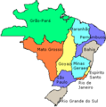
The Federative Republic of Brazil is a union of twenty-six estados ("states"; singular estado) and one district, the Distrito Federal ("Federal District") which contains the capital city, Brasília.
States are generally based on historical, conventional borders and have developed throughout the centuries; though some boundaries are arbitrary. The federal district is not a state on its right, but shares some characteristics of a state and some of a municipality.
The Federal District is encompassed by the state of Goiás and Minas Gerais. The codes given below are defined in ISO 3166-2:BR.
History
The first administrative divisions of Brazil were the hereditary captaincies (capitanias hereditárias), stretches of land leased to Portuguese noblemen or merchants with a charter to build improvements and colonize the land. They were so-called hereditary because the grant was to be passed from father to son, but the crown retained the power of revoking it, which the king indeed did on later 16th century. Then the vast Portuguese dominion on South America was divided between the State of Brazil, in the southern half, and the State of Maranhão, in the northern half (note that Maranhão by then referred not only to current Maranhão, but rather to the whole of the Amazon region; the name marã-nã in Old Tupi language means "wide river", i.e., the Amazon river).
After the Iberian Union (1580-1640), the territory of Portuguese colonial domains in South America were more than doubled, and the land was divided in captaincies, royal captaincies and provinces. Unlike Spanish America, the whole land was united under a single viceroy, with a seat in Salvador (and, after 1763, Rio de Janeiro). This fact would later contribute to avoid the fragmentation of Brazil and keep it as a unified nation-state.
With independence, in 1822, the colony became an empire and all captaincies were turned into provinces. Most internal borders were kept unchanged from the colonial period, most of them with a strong following of natural division lines (such as rivers, mountain ridges etc.). Minor changes were made to suit domestic politics (such as the Triângulo Mineiro from Goiás to Minas Gerais, the splitting of Paraná and the left bank of the São Francisco river from Pernambuco to Bahia), as well as additions resulting from diplomatic settlement of territorial disputes by the end of the 19th century (Amapá, Roraima, Palmas). When the regime changed to republic, in 1889, all provinces were immediately turned into states.
In 1943, with the entrance of Brazil into the Second World War, the Vargas regime detached seven strategic territories from the border of the country in order to administer them directly: Amapá, Rio Branco, Acre, Guaporé, Ponta Porã, Iguaçu and the archipelago of Fernando de Noronha. After the war, the first three territories were retained as states, with Rio Branco and Guaporé being renamed Roraima and Rondônia, respectively. Ponta Porã and Iguaçu resorted to territorial status. In 1988, Fernando de Noronha became part of Pernambuco.
In 1960, the square-shaped Distrito Federal was carved out of Goiás in preparation for the new capital, Brasília. The previous federal district became the state of Guanabara until in 1975 it was merged with the state of Rio de Janeiro, retaining its name and with the municipality of Rio de Janeiro as its capital.
In 1977, Mato Grosso was split into two states. The northern area retained the name Mato Grosso while the southern area became the state of Mato Grosso do Sul, with Campo Grande as its capital. The new Mato Grosso do Sul incorporated the territory of Ponta Porã and the northern part of Iguaçu. Central Iguaçu went to Paraná, and southern Iguaçu went to Santa Catarina.
In 1988, the northern portion of Goiás became the state of Tocantins, with Palmas as its capital.
-

-
 1573
1573
Two states -
 1709
1709
São Paulo at its greatest extent. -
-
 1823
1823
Imperial provinces -
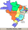 1889
1889
At the Start of Republic -
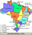 1943
1943
Border territories -
 1990
1990
Current


List of Brazilian states
| Flag | State | Abbreviation | Capital | Area (km²) | Population (2005) | Density (2005) | GDP (% total) (2007) | GDP per capita PPP (US$) (2007) | HDI (2005) | Literacy (2003) | Infant Mortality (2002) | Life Expectancy (2004) |
|---|---|---|---|---|---|---|---|---|---|---|---|---|
| Acre | AC | Rio Branco | 152,581.4 | 656,043 | 4.30 | 5,761,000 (0.2%) | 8,789 | 0.751 | 84% | 33.2‰ | 70.8 | |
| Alagoas | AL | Maceió | 27,767.7 | 3,015,912 | 108.61 | 17,793,000 (0.7%) | 5,858 | 0.677 | 70% | 57.7‰ | 66.0 | |
| Amapá | AP | Macapá | 142,814.6 | 594,587 | 4.16 | 6,022,000 (0.2%) | 10,254 | 0.780 | 91% | 24.9‰ | 69.8 | |
| Amazonas | AM | Manaus | 1,570,745.7 | 3,232,330 | 2.05 | 42,023,000 (1.6%) | 13,043 | 0.780 | 94% | 20.8‰ | 73.4 | |
| Bahia | BA | Salvador | 564,692.7 | 13,815,334 | 24.46 | 109,652,000 (4.1%) | 7,787 | 0.742 | 79% | 38.7‰ | 71.4 | |
| Ceará | CE | Fortaleza | 148,825.6 | 8,097,276 | 54.40 | 50,331,000 (1.9%) | 6,149 | 0.723 | 78% | 35.1‰ | 69.6 | |
| Distrito Federal | DF | Brasília | 5,822.1 | 2,333,108 | 400.73 | 99,946,000 (3.8%) | 40,696 | 0.874 | 96% | 17.5‰ | 74.9 | |
| Espírito Santo | ES | Vitória | 46,077.5 | 3,408,365 | 73.97 | 60,340,000 (2.3%) | 18,003 | 0.802 | 90% | 20.9‰ | 73.1 | |
| Goiás | GO | Goiânia | 340,086.7 | 5,619,917 | 16.52 | 65,210,000 (2.5%) | 11,548 | 0.800 | 90% | 20.7‰ | 72.8 | |
| Maranhão | MA | São Luís | 331,983.3 | 6,103,327 | 18.38 | 31,606,000 (1.2%) | 5,165 | 0.683 | 77% | 46.3‰ | 66.8 | |
| Mato Grosso | MT | Cuiabá | 903,357.9 | 2,803,274 | 3.10 | 42,687,000 (1.6%) | 14,954 | 0.796 | 90% | 21.5‰ | 72.6 | |
| Mato Grosso do Sul | MS | Campo Grande | 357,125.0 | 2,264,468 | 6.34 | 28,121,000 (1.1%) | 12,411 | 0.802 | 91% | 19.2‰ | 73.2 | |
| Minas Gerais | MG | Belo Horizonte | 586,528.3 | 19,237,450 | 32.79 | 241,293,000 (9.1%) | 12,519 | 0.800 | 89% | 20.8‰ | 74.1 | |
| Pará | PA | Belém | 1,247,689.5 | 6,970,586 | 5.58 | 49,507,000 (1.9%) | 7,007 | 0.755 | 90% | 27.3‰ | 71.4 | |
| Paraíba | PB | João Pessoa | 56,439.8 | 3,595,886 | 63.71 | 22,202,000 (0.8%) | 6,097 | 0.718 | 75% | 45.5‰ | 68.3 | |
| Paraná | PR | Curitiba | 199,314.9 | 10,261,856 | 51.48 | 161,582,000 (6.1%) | 15,711 | 0.820 | 93% | 20.7‰ | 73.5 | |
| Pernambuco | PE | Recife | 98,311.6 | 8,413,593 | 85.58 | 62,256,000 (2.3%) | 7,337 | 0.718 | 79% | 44.8‰ | 67.5 | |
| Piauí | PI | Teresina | 251,529.2 | 3,006,885 | 11.95 | 14,136,000 (0.5%) | 4,662 | 0.703 | 72% | 33.1‰ | 68.2 | |
| Rio de Janeiro | RJ | Rio de Janeiro | 43,696.1 | 15,383,407 | 352.05 | 296,768,000 (11.2%) | 19,245 | 0.832 | 96% | 19.5‰ | 72.4 | |
| Rio Grande do Norte | RN | Natal | 52,796.8 | 3,003,087 | 56.88 | 22,926,000 (0.9%) | 7,607 | 0.738 | 77% | 41.9‰ | 69.8 | |
| Rio Grande do Sul | RS | Porto Alegre | 281,748.5 | 10,845,087 | 38.49 | 176,615,000 (6.6%) | 16,689 | 0.832 | 95% | 15.4‰ | 74.5 | |
| Rondônia | RO | Porto Velho | 237,576.2 | 1,534,594 | 6.46 | 15,003,000 (0.6%) | 10,320 | 0.776 | 92% | 24.6‰ | 70.6 | |
| Roraima | RR | Boa Vista | 224,299.0 | 391,317 | 1.74 | 4,169,000 (0.2%) | 10,534 | 0.750 | 91% | 17.8‰ | 69.3 | |
| Santa Catarina | SC | Florianópolis | 95,346.2 | 5,866,568 | 61.53 | 104,623,000 (3.9%) | 17,834 | 0.840 | 95% | 18.2‰ | 74.8 | |
| São Paulo | SP | São Paulo | 248,209.4 | 40,442,795 | 162.93 | 902,784,000 (33.9%) | 22,667 | 0.833 | 95% | 17.4‰ | 73.7 | |
| Sergipe | SE | Aracaju | 21,910.3 | 1,967,761 | 89.81 | 16,896,000 (0.6%) | 8,712 | 0.742 | 90% | 40.6‰ | 70.3 | |
| Tocantins | TO | Palmas | 277,620.9 | 1,305,728 | 4.70 | 11,094,000 (0.4%) | 8,921 | 0.756 | 83% | 28.4‰ | 70.7 |
See also
- Brazil Socio-Geographic Division
- List of Brazil state name etymologies
- List of major cities in Brazil
External links
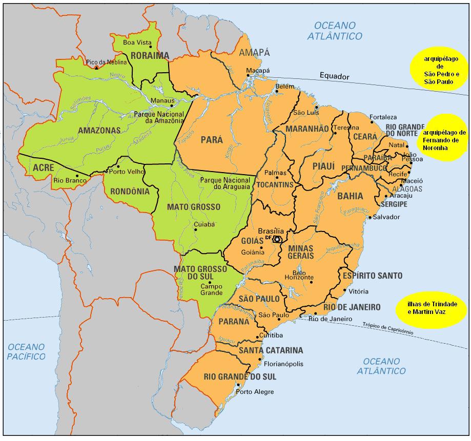
- Map of Brazil, showing states and their regular timezones - yellow for -02:00 GMT, orange for -03:00 GMT and green for -04:00 GMT
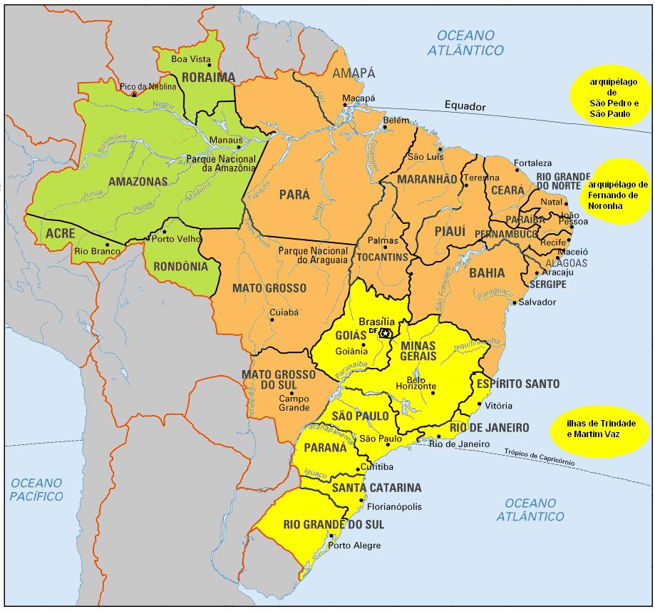
- Map of Brazil, showing states and their daylight saving times observed from the 3rd sunday of october to the 3rd sunday of february, yearly - yellow for -02:00 GMT, orange for -03:00 GMT and green for -04:00 GMT
- Template:Pt icon Portal of Brazilian municipalities
- Tourist Cities from Brazil